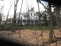
History
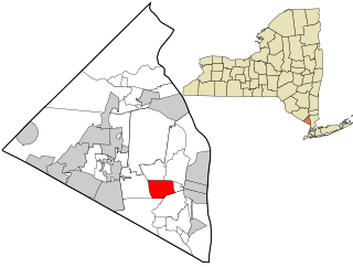
Upper Nyack was incorporated in 1872. Two hundred years prior, Claus Jansen Purarent of Bergen Township (now Jersey City) received a patent from Governor Phillip Carteret for 640 acres (260 ha) of land north of Tappan. Jansen sold 100 acres (40 ha) to Dowe Harmensen Tallman, and the rest was inherited by his son Cornelius Clausen, who assumed the surname of Kuyper (Cooper). Kuyper was an outstanding public servant in the County of Orange. The first Upper Nyacker also commanded the first company of militia in the county. He died in 1731 and is buried in the Upper Nyack Burial Grounds.
Following the extension of the Northern Railroad of New Jersey into the area in the mid-19th century, rapid growth ensued. Town government no longer being seen as an effective means of dealing with the needs of Nyack proper, village incorporation was discussed. Fearing higher taxes, those in what would have become the northern part of Nyack village formed their own municipal corporation first, named Upper Nyack. Nyack village still incorporated, too, although without this northern portion. [3]
In 1909, the village was known locally as "Goosetown", probably due to a Colonel Vose, who lived on Highmount Avenue and kept geese which he drove daily down to the river, thus giving the thought that Upper Nyack was full of/for the birds. The slogan "Goosetown against the world" was adopted in 1909 due to a local dispute. During the celebration of Upper Nyack's Centennial in 1972, Upper Nyackers proudly displayed bumper stickers again with the words "GOOSETOWN AGAINST THE WORLD".
Demographics
As of the census [6] of 2000, there were 1,863 people, 712 households, and 524 families residing in the village. The population density was 1,406.8 inhabitants per square mile (543.2/km2). There were 732 housing units at an average density of 552.7 per square mile (213.4/km2). The racial makeup of the village was 92.54% White, 3.33% African American, 0.05% Native American, 2.31% Asian, 0.43% from other races, and 1.34% from two or more races. Hispanic or Latino of any race were 4.13% of the population.
There were 712 households, out of which 31.5% had children under the age of 18 living with them, 64.3% were married couples living together, 6.5% had a female householder with no husband present, and 26.4% were non-families. 21.9% of all households were made up of individuals, and 9.8% had someone living alone who was 65 years of age or older. The average household size was 2.58 and the average family size was 3.01.
In the village, the population was spread out, with 22.1% under the age of 18, 4.1% from 18 to 24, 24.2% from 25 to 44, 33.9% from 45 to 64, and 15.6% who were 65 years of age or older. The median age was 45 years. For every 100 females, there were 92.1 males. For every 100 females age 18 and over, there were 86.3 males.
The median income for a household in the village was $91,156, and the median income for a family was $103,049. Males had a median income of $66,607 versus $41,406 for females. The per capita income for the village was $52,368. About 2.4% of families and 3.4% of the population were below the poverty line, including 0.8% of those under age 18 and 6.6% of those age 65 or over.

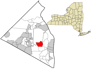
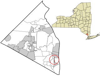
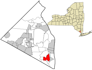
Rockland County is the second-southernmost county on the west side of the Hudson River in the U.S. state of New York, after Richmond County. It is part of the New York metropolitan area. As of the 2020 U.S. census, the county's population is 338,329, making it the state's third-most densely populated county outside New York City after Nassau and neighboring Westchester Counties. The county seat and largest hamlet is New City. Rockland County is accessible via the New York State Thruway, which crosses the Hudson to Westchester at the Tappan Zee Bridge ten exits up from the NYC border, as well as the Palisades Parkway five exits up from the George Washington Bridge. The county's name derives from "rocky land", as the area has been aptly described, largely due to the Hudson River Palisades. The county is part of the Hudson Valley region of the state.

Sloan is a village in Erie County, New York, United States. The population was 3,661 at the 2010 census. It is part of the Buffalo–Niagara Falls Metropolitan Statistical Area and is in the town of Cheektowaga.
Bardonia is a hamlet and census-designated place in the town of Clarkstown, Rockland County, New York, United States. It is located northeast of Nanuet, northwest of West Nyack, south of New City, and west of Valley Cottage. The population was 4,108 at the 2010 census.

Blauvelt is a hamlet, about 20 miles northwest of New York City. It was a census-designated place, formerly known as Greenbush and then Blauveltville, in the town of Orangetown, Rockland County, New York, United States. It is located north of Tappan, east of Nauraushaun and Pearl River, south of Central Nyack, and west of Orangeburg. As of the 2010 census, the CDP had a population of 5,689.

Clarkstown is a town in Rockland County, New York, United States. The town is on the eastern border of the county, located north of the town of Orangetown, east of the town of Ramapo, south of the town of Haverstraw, and west of the Hudson River. As of the 2020 census, the town had a total population of 86,855. The hamlet of New City, the county seat of Rockland County, is also the seat of town government and of the Clarkstown Police Department, the county sheriff's office, and the county correctional facility. New City makes up about 41.47% of the town's population.
Grand View-on-Hudson is a village incorporated in 1918 in the town of Orangetown in Rockland County, New York, United States. It is located north of Piermont, east of Orangeburg, south of South Nyack, and west of the Hudson River. The population was 285 at the 2010 census. The name is derived from the scenic view from its location.

Hillcrest is a hamlet incorporated in 1893 and census-designated place, in the town of Ramapo, Rockland County, New York, United States. It is located north of Spring Valley, east of Viola, south of New Square and New Hempstead, and west of New City. The population was 8,164 at the 2020 census.

New Hempstead is a village in the town of Ramapo, Rockland County, New York, United States. It is located north of New Square, east of Wesley Hills, south of Pomona, and west of New City. The population was 5,132 at the 2010 census. Residents utilize the Spring Valley and New City post offices.

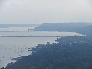
Nyack is a village located primarily in the town of Orangetown in Rockland County, New York, United States. Incorporated in 1872, it retains a very small western section in Clarkstown. The village had a population of 7,265 as of the 2020 census. It is a suburb of New York City lying approximately 15 miles (24 km) north of the Manhattan boundary near the west bank of the Hudson River, situated north of South Nyack, east of Central Nyack, south of Upper Nyack, and southeast of Valley Cottage.
Orangeburg is a hamlet and census-designated place, in the town of Orangetown, Rockland County, New York, United States. It is located north of Tappan, south of Blauvelt, east of Pearl River and west of Piermont. The population was 4,568 at the 2010 census.
Orangetown is a town in Rockland County, New York, United States, located in the southeastern part of the county. It is northwest of New York City, north of New Jersey, east of the town of Ramapo, south of the town of Clarkstown, and west of the Hudson River. The population was 48,655 at the 2020 census.

Piermont is a village incorporated in 1847 in Rockland County, New York, United States. Piermont is in the town of Orangetown, located north of the hamlet of Palisades, east of Sparkill, and south of Grand View-on-Hudson, on the west bank of the Hudson River. The population was 2,517 at the 2020 census. Woody Allen set The Purple Rose of Cairo (1984) in Piermont.

South Nyack is a hamlet and census-designated place in the town of Orangetown in Rockland County, New York, United States. It is located north of Grand View-on-Hudson, northeast of Orangeburg, east of Blauvelt State Park, south of Nyack and west of the Hudson River. The hamlet is the western terminus of the Tappan Zee Bridge. Its population was 3,510 at the 2010 census. The hamlet was formerly incorporated as a village from 1878 until 2022.

Valley Cottage is a hamlet and census-designated place in the town of Clarkstown, New York, United States. It is located northeast of West Nyack, northwest of Central Nyack east of Bardonia, south of Congers, northwest of Nyack, and west of Upper Nyack. The population was 9,107 at the 2010 census.

Wesley Hills is a village in the town of Ramapo, Rockland County, New York, United States. It is located north of Viola, east of Harriman State Park, south of Pomona, and west of New Hempstead. The population was 5,628 at the 2010 census.

West Haverstraw is a village incorporated in 1883 in the town of Haverstraw, Rockland County, New York, United States. It is located northwest of Haverstraw village, east of Thiells, south of the hamlet of Stony Point, and west of the Hudson River. The population was 10,165 at the 2010 census. The majority of the hamlet of Garnerville is contained in the village of West Haverstraw.
West Nyack is a hamlet and census-designated place in the town of Clarkstown, Rockland County, New York, United States. It is located north of Blauvelt, east of Nanuet, southwest of Valley Cottage, southeast of Bardonia, and west of Central Nyack. It is approximately 18 miles (29 km) north of New York City. The population was 3,439 at the 2010 census.

Greenburgh is a town in western Westchester County, New York. The population was 95,397 at the time of the 2020 census.

Alden is a village in Erie County, New York, United States. The population was 2,605 at the 2010 census. It is part of the Buffalo–Niagara Falls Metropolitan Statistical Area.
Fort Edward is a village in Washington County, New York, United States. It is part of the Glens Falls Metropolitan Statistical Area. The village population was 3,375 at the 2010 census. The name is derived from the younger brother of King George III, Edward Augustus, Duke of York and Albany.