This article needs additional citations for verification .(December 2015) |
Un Estates or Kankrej thana was a former collection of native states in what is now part of Banaskantha district of Gujarat, India.
This article needs additional citations for verification .(December 2015) |
Un Estates or Kankrej thana was a former collection of native states in what is now part of Banaskantha district of Gujarat, India.
The thana was divided between vaghela's rajput jagir of 21 Un,and 26 talukdar's petty estate holders belong to rajput clan..The most important of these were Thara, Kamboi and vada. Most of the estates were small, often covering not even a single village, but parts of several villages shared with others. There were numerous bhayad's (land alienated to junior branches) of these petty chiefs, but the lands were not actually surveyed and divided; they simply occupied as much as land as they could cultivate. Without Un estates Primogeniture was not observed in any of the estates of Kankrej Thana; rather, gira's were divided up in equal shares among all sons.
Kankrej chiefs agreed with British in 1819–20 to become protectorate and came under Mahi Kantha Agency. It continued part of the Mahi Kantha till, in 1844, on account of its nearness to Palanpur, it was transferred to the Palanpur Superintendency. [1]
Kankrej was under Palanpur Agency of Bombay Presidency, [2] which in 1925 became the Banas Kantha Agency. After Independence of India in 1947, Bombay Presidency was reorganized in Bombay State. When Gujarat state was formed in 1960 from Bombay State, it fell under Banaskantha district of Gujarat.
Radhanpur is a city and a municipality in Patan district in the Indian state of Gujarat.
Deesa is a city and a municipality in the Banaskantha district in the state of Gujarat, India.
Tharad is a Taluka of Banaskantha district in Gujarat in India. It is the administrative center of Tharad taluka. Here is 134 villages. Tharad is 45km near to international boarder with Pakistan and 40km to national boarder with Rajasthan. main industries are agriculture and private businesses. It is one of the first major towns in Gujarat on National Highway 68.
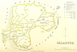
Palanpur Agency, also spelled Pahlunpore Agency, was a political agency or collection of princely states in British India, within the Gujarat Division of Bombay Presidency. In 1933, the native states of the Mahi Kantha Agency, except for Danta, were included in the Western India States Agency. The agency, headquartered at Palanpur, oversaw some 17 princely states and estates in the area, encompassing an area of 6393 square miles (16,558 km2) and a population, in 1901, of 467,271.

Vav is a town and the headquarters of Vav Taluka in banaskantha district in Gujarat state of India. Vav is the largest taluka of the district.

Radhanpur is a town and a municipality in Patan district in the Indian state of Gujarat. Radhanpur belonged to the Vaghelas in early years and later it was held as a fief under the Gujarat Sultanate by Fateh Khan Baloch. During Mughal period, the descendants of Babi dynasty were appointed as the governor of Radhanpur and other villages of North Gujarat. After decline of Mughal, they became free and established themselves as independent rulers. In 1743, Babi descendant Jawan Mard Khan II took over viceroyalty of Ahmedabad and controlled several villages in North Gujarat.He was defeated by vaghela Un Jagir in 1753. He was defeated by Maratha Gaekwads in 1753 at Ahmedabad and Gaekwads agreed to his demand of control of villages in North Gujarat headquartered at Radhanpur State. His descendants lost some of these villages to Gaekwads subsequently. In 1813, Sher Khan made a treaty with the Gaekwar and British and became British protectorate. His descendants ruled the state until independence of India in 1947.
Santalpur is a village in Santalpur Taluka of Patan district of Gujarat state, India.
Varahi is a village in Santalpur taluka of Patan district of Gujarat state of India.
Diyodar, also spelled Diodar or Deodar, is a town and former princely state in Diyodar Taluka of Banaskantha district in Gujarat, western India.
Suigam was a village in Vav Taluka of Maratha Riyasat in Gujarat, India, but it is now a Taluka of Banaskantha district in Gujarat.
Tervada is a village in Kankrej Taluka of Banaskantha district in Gujarat, India.
Morvada is a village in Vav Taluka of Banaskantha district in Gujarat, India.
Bhabhar is a town in the Banaskantha district of Gujarat, India.
Dhima is a village in Vav Taluka of Banaskantha district in Gujarat, India.
Kakar is a village in Kankrej Taluka of Banaskantha district in Gujarat, India.
Kasara is a village in Kankrej Taluka of Banaskantha district in Gujarat, India.
Panchasar is a village in Shankheshwar Taluka of Patan district of Gujarat, India.
Sami is a town in Sami Taluka of Patan district of Gujarat, India.
Vaghel is a village in Harij Taluka of Patan district in Gujarat, India.
Chadchat is a region surrounding Santalpur in Patan district of Gujarat, India.