This page provides a historical timeline of Ahmedabad, the sixth largest city in India.

Navsari is an administrative district in the state of Gujarat in India, with its headquarters at the city of Navsari. The district covers an area of 2,211 square kilometres and was formed in 1997 after Valsad district was split into Valsad and Navsari districts. It is the largest producer of chikoos in India.

Palanpur is a city and a headquarters of Banaskantha district in the Indian state of Gujarat. Palanpur is the ancestral home to an industry of Indian diamond merchants.
Danta is a city in the taluka of the same name in the Banaskantha district of the Indian state of Gujarat. It lies about 150 km north of Ahmedabad city, and on the border of Gujarat with Rajasthan.
Ambaji (Ambājī) is a census town in Banaskantha district in the state of Gujarat, India.

Adalaj is a census town in Gandhinagar district located in the western Indian state of Gujarat. With a population of roughly 12,000 residents within the town limits as of 2011, Adalaj is known for its semi-arid climate and its historic and religious establishments. The town sits in a generally flat area covering about 18 sq. km.
Mahemdavad is a town with municipality in the Kheda district in the Indian state of Gujarat. Mahemdavad is situated on the Vatrak River bank. The nearest city is Kheda. It is 30 km from largest city of Gujarat, Ahmedabad.
Mahuva is a town and taluka of Bhavnagar District, in the state of Gujarat, India. Located on the coast of the Arabian Sea, Mahuva is known for its mild weather and green, lush surroundings, including many coconut tree plantations. The town is a part of the Saurashtra region and is known as the Kashmir of Saurashtra. Mahuva is also known for wooden toys, raw onions, groundnuts, and a local variety of mango called the Jamadar. The region is home to a thriving agribusiness industry, particularly enterprises that dehydrate vegetables such as garlic and onions for use in processed foods.
Una is a town and a municipality in Gir Somnath district of the Saurashtra region in the state of Gujarat, India.
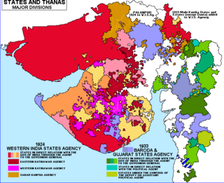
The Western India States Agency (WISA) was one of the agencies of British India. This agency was formed on 10 October 1924 as a part of the implementation of the Montague Chelmsford report on constitutional reforms. It was formed by merging the areas under the erstwhile Kathiawar, Cutch and Palanpur agencies.
Shirpur is a town and taluka in Dhule district of Nashik Division, Maharashtra, India. It is located on National Highway 3, which runs from Agra in Uttar Pradesh to Mumbai, Maharashtra. The Arunavati River and Tapi river flows through the city. Shirpur is 50 km from the city of Dhule. It houses Asia's largest and India's first gold refinery. Narsee Monjee Institute of Management Studies has a campus in Shirpur. Ahead of Shirpur there is a small private airport at Village Tande.

Rajkot State was one of the princely states of India during the period of British rule. It was a 9-gun salute state belonging to the Kathiawar Agency of the Bombay Presidency. Its capital was in Rajkot, located in the historical Halar region of Kathiawar on the banks of the Aji River. Nowadays, Rajkot is the fourth largest city of Gujarat state.

Kolhapur State or Kolhapur Kingdom (1710–1949) was a Maratha princely State of India, under the Deccan Division of the Bombay Presidency, and later the Deccan States Agency. It was considered the most important of the Maratha principalities with the others being Baroda State, Gwalior State and Indore State. Its rulers, of the Bhonsle dynasty, were entitled to a 19-gun salute – thus Kolhapur was also known as a 19-gun state. The state flag was a swallow-tailed saffron pennant.
Telnar or Telnal is a village in Kapadvanj Taluka in Kheda district of Gujarat state, India.

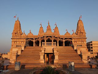
Palanpur State was a princely state of India during the British Raj. It was a Salute state with the Nawab of Palanpur having a hereditary salute of 13-guns. It was the main state of the Palanpur Agency. Palanpur State became a British protectorate in 1809/17; its capital was the city of Palanpur.

Kumbhariya is a village of historical, archaeological and religious importance with cultural heritage in Danta Taluka of Banaskantha district, Gujarat, India.
Chamardi is a large village located within the Vallabhipur Taluka township of the Bhavnagar district (Gujarat), in West India. It was formerly a part of Rajput princely state.


