Jafarabad State

Last updated

Jafarabad State
Jafrabad State
જાફરાબાદ રિયાસત
Princely State of British India
In union with Janjira (1759–1948)
c. 1650–1948
Jafarabad State Merchant Flag vector.svg
Flag
SaurashtraKart.svg
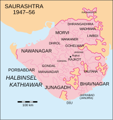
Location of Jafrabad State in Saurashtra
Area 
 1901
68 km2 (26 sq mi)
Population 
 1901
12,097
History
History 
 Established
c. 1650
1948
Succeeded by
India Flag of India.svg
Today part of Gujarat, India

Jafarabad, or Jafrabad State [1] , was a tributary princely state in India during the British Raj. It was located in the Kathiawar Peninsula on the Gujarat coast. The state had formerly been part of the Baroda Agency and later of the Kathiawar Agency of the Bombay Presidency.

Contents

Jafrabad State was a dependency of the Nawab of Janjira State, [2] located 320 km to the SSE on the Konkan coast.

Jafrabad town, the capital and only municipality, is located 275 km south of Ahmedabad and 240 southwest of Baroda. The state was formed by the city and 11 villages and initially consisted of two districts located on both sides of the estuary of the Ranai river. Jafrabad state had an area of 68 km2 and a population in 1881 of 4,746 and in 1901 of 6,038 inhabitants. The majority of the population were Muslims (80%) and the rest Hindus. The state and the town took their name from Sultan Muzaffar Jafar from Gujarat who built fortifications.[ citation needed ]

History

Jafarabad State was founded around 1650. On 6 December 1733 the ruler of Jafarabad State signed a defensive and offensive treaty with the British East India Company. In 1759, the Jafarabad and Janjira states entered into a personal union. Finally in 1834 Jafarabad State became a British protectorate.

Around 1731 when the Mughal Empire rule was relaxed in Gujarat, the local Thanedar (ruler) who was an ally in the Muslim Mughal garrison became independent. Thereafter the Thanedar and the local Kolis were devoted to piracy, repeatedly attacking ships and disturbing commercial traffic from Surat. Sidi Hilal, the prince of the dynasty of Janjira which was then ruling Surat, attacked the Kolis, destroyed their boats and captured them demanding a hefty fine. [3]

See also

Related Research Articles

<span class="mw-page-title-main">Bombay Presidency</span> Province in India (1668–1947)

The Bombay Presidency or Bombay Province, also called Bombay and Sind (1843–1936), was an administrative subdivision (province) of India, with its capital in the city that came up over the seven islands of Bombay. The first mainland territory was acquired in the Konkan region with the Treaty of Bassein (1802). Mahabaleswar was the summer capital.

<span class="mw-page-title-main">Amreli district</span> District of Gujarat in India

Amreli district is one of the 33 administrative districts of the state of Gujarat in western India. The district headquarters are located at Amreli. The district occupies an area of 6,760 km2 and has a population of 1,514,190 of which 22.45% were urban. Amreli is the land of Yogiji Maharaj(Dhari), Danbapu, Sage Muldas, Sage Bhojalrambapa, Sage Muktanand Swami, Magician K.Lal, Zaverchand Megahani's place (Bagasara), Dr. Jivaraj Mehata etc. Amreli covers Dhari Gir National forest sanctuary area. Now it is developing as a Hub of Education.

Murud-Janjira is the local name of a famous fort and tourist spot situated on an island just off the coastal town of Murud, in the Raigad district of Maharashtra, India.

The history of Gujarat began with Stone Age settlements followed by Chalcolithic and Bronze Age settlements like Indus Valley civilisation. Gujarat's coastal cities, chiefly Bharuch, served as ports and trading centers in the Nanda, Maurya, Satavahana and Gupta empires as well as during the Western Kshatrapas period. After the fall of the Gupta empire in the 6th century, Gujarat flourished as an independent Hindu-Buddhist state. The Maitraka dynasty, descended from a Gupta general, ruled from the 6th to the 8th centuries from their capital at Vallabhi, although they were ruled briefly by Harsha during the 7th century. The Arab rulers of Sindh sacked Vallabhi in 770, bringing the Maitraka dynasty to an end. The Gurjara-Pratihara Empire ruled Gujarat after from the 8th to 10th centuries. While the region also came under the control of the Rashtrakuta Empire. In 775 the first Parsi (Zoroastrian) refugees arrived in Gujarat from Greater Iran.

Jafrabad is a town and a nagarpalika in Amreli District in the Indian state of Gujarat.

Mercenaries in India were fighters, primarily peasants, who came from India and abroad, to fight for local rulers in India in the medieval period. This mercenary work became an important source of income for some communities.

<span class="mw-page-title-main">Bhavnagar State</span> Princely state of India

Bhavnagar State was a princely state with 13 Gun Salutes during the British Raj. It was part of Kathiawar Agency in Saurashtra. The hereditary Kotwals of the royal palace of Bhavnagar were Talpada Kolis of Radhavanaj village of Kheda district.

<span class="mw-page-title-main">Rajkot State</span> Princely state of India

Rajkot State was one of the princely states of India during the period of British rule. It was a 9-gun salute state belonging to the Kathiawar Agency of the Bombay Presidency. Its capital was in Rajkot, located in the historical Halar region of Kathiawar on the banks of the Aji River. Nowadays, Rajkot is the fourth largest city of Gujarat state.

<span class="mw-page-title-main">Pathans of Gujarat</span> Indian people of Pashtun origin

GujaratiPathans are a group of Pashtuns who are settled in the region of Gujarat in western India. They now form a distinct community of Gujarati and Urdu/Hindi speaking Muslims. They mainly speak Urdu/Hindi with many Pashto loanwords, but most of them have been Indianized so some may have Gujarati as their first language as well, few elders in the community still speak Pashto. Common tribes include Babi or Babai, Niazi, Khan, Bangash, Durrani, and Yousafzai.

<span class="mw-page-title-main">Baroda State</span> Princely state of India (1721–1949)

Baroda State was a princely state in present-day Gujarat, ruled by the Gaekwad dynasty of the Maratha Confederacy from its formation in 1721 until its accession to the newly formed Dominion of India in 1949. With the city of Baroda (Vadodara) as its capital, during the British Raj its relations with the British were managed by the Baroda Residency. The revenue of the state in 1901 was Rs. 13,661,000. Baroda formally acceded to the Dominion of India, on 1 May 1949, prior to which an interim government was formed in the state.

<span class="mw-page-title-main">Jawhar State</span> Princely state of India (1343–1947)

The Jawhar State was a princely state in India. As a princely state, it became a part of Bombay Presidency during the British Raj. It was the only state belonging to the Thana Agency.

<span class="mw-page-title-main">Koli people</span> Indian caste

The Koli is an Indian caste found in Rajasthan, Himachal Pradesh, Gujarat, Maharashtra, Uttar Pradesh, Haryana, Karnataka, Odisha and Jammu and Kashmir states in India. Koli is an agriculturist caste of Gujarat but in coastal areas they also work as fishermen along with agriculture. In the beginning of 20th century, the Koli caste was recognised as a Criminal Tribe under Criminal Tribes Act by the Indian Government because of their anti-social activities during World War I.

<span class="mw-page-title-main">Mewasi</span> Koli title

The Mewasi, or Mevasi, Mehwasi is a title of Koli caste found in Indian state of Gujarat. The Koli chieftains who ruled over villages populated by turbulent Kolis were titled as Mewasi because of their rebellious activities against Maratha and Mughal rulers.

<span class="mw-page-title-main">Baroda and Gujarat States Agency</span>

Baroda and Gujarat States Agency was a political agency of British India, managing the relations of the British government of the Bombay Presidency with a collection of princely states.

<span class="mw-page-title-main">Baroda, Western India and Gujarat States Agency</span> Agency of India from 1944 to 1947

The Baroda, Western India and Gujarat States Agency was an agency of the Indian Empire, managing the relations of the Provincial Government of the Bombay Presidency with a collection of princely states.

<span class="mw-page-title-main">Jambughoda State</span>

Jambughoda State, previously known as Narukot and Tokalpur state, was a small princely state in India during the time of the British Raj. Its last ruler acceded to the Union of India on 10 June 1948.

<span class="mw-page-title-main">Janjira State</span> Princely state of India

Janjira State was a princely state in India during the British Raj. Its rulers were a Siddi dynasty of Habesha descent and the state was under the suzerainty of the Bombay Presidency.

<span class="mw-page-title-main">Radhanpur State</span> Princely state of India

Radhanpur State was a princely state in India during the British Raj. Its rulers belonged to a family of Babi House, the state was once a polity within the Mughal Empire. The last ruling Nawab of Radhanpur, Nawab Murtaza Khan, signed the instrument of accession to the Indian Union on 10 June 1948.

Kamadhia is a town and former princely state in the western Indian state of Gujarat.

Gujarat is a state along the western coast of India. Its coastline of about 1,600 km is the longest in the country, most of which lies on the Kathiawar peninsula. Gujarat is the fifth-largest Indian state by area, covering some 196,024 km2 ; and the ninth-most populous state, with a population of 60.4 million. It is bordered by Rajasthan to the northeast, Dadra and Nagar Haveli and Daman and Diu to the south, Maharashtra to the southeast, Madhya Pradesh to the east, and the Arabian Sea and the Pakistani province of Sindh to the west. Gujarat's capital city is Gandhinagar, while its largest city is Ahmedabad.

References

  1. Vadivelu, A. (1915). The Ruling Chiefs, Nobles & Zamindars of India. Vol. One. Madras: G. C. Loganadham Bros. p. 325.
  2. Chisholm, Hugh, ed. (1911). "Jafarabad"  . Encyclopædia Britannica . Vol. 15 (11th ed.). Cambridge University Press. p. 125.
  3. Robbins, Kenneth X.; McLeod, John (2006). African elites in India: Habshi Amarat. Mapin. pp. 272 Pages. ISBN   1890206970.

20°52′00″N71°22′00″E / 20.8667°N 71.3667°E / 20.8667; 71.3667