Barwani State

Last updated

Barwani State
बड़वानी रियासत
Princely State of British India
836–1948
Drapeau Barwani.png
Flag
Barwani State coat of arms.png
Coat of arms
Barwani-Dhar map.jpg
Barwani State in the Imperial Gazetteer of India
Capital Barwani
Area 
 1941
3,051.02 km2 (1,178.01 sq mi)
Population 
 1941
176,666
History 
 Established
836
1948
Succeeded by
India Flag of India.svg
Today part of Madhya Pradesh, India
Barwani Princely State
Maharaja Ranjit Singh of Barwani (1888 - 1930) with ambulance cars in Merville, France, during World War I The Maharaja of Barwani with ambulance cars (Merville, France). Photographer- H. D. Girdwood. (13874885655).jpg
Maharaja Ranjit Singh of Barwani (1888 - 1930) with ambulance cars in Merville, France, during World War I

Barwani State [1] was a princely state in India. It is ruled by Sisodiya rajput. The seat was at Barwani.

Contents

History

Bhopawar Agency Information Bhopawar Agency States and estates.jpg
Bhopawar Agency Information

The state was founded in the 11th or 14th century, at which time it was known as Avasgarh. [1] the Rana's of Avasgarh were Sisodia's who claimed to be the descendants of Bappa Rawal. The records of the state claim that Awasgarh had 51 Rana's however there is little information about their names or the dates they reigned in. Parsan Singh, the 35th Rana was defeated by the Sultan of Delhi and taken as prisoner, the rana agreed to covert to Islam on the condition that he gets his ancestral lands back. 3 of Parsans descendants were Muslims although they followed their Hindu customs, the Rana's eventually converted back to Hinduism. The 41st Rana Chandra Singh moved his capital to the safer position of Barwani. The state lost most of its territory during the Maratha domination in the 17th century, however it never became tributary to any Major power. [2]

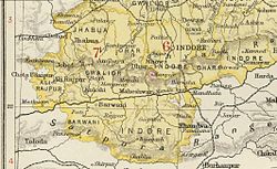
Under the British Raj, Barwani was a state of the Bhopawar Agency, a division of the Central India Agency. The state lay in the Satpura Range south of the Narmada River. It had an area of 3,051 km2 (1,178 sq mi) and a population, in 1901, of 76,136. The average revenue of the state was Rs.4,00,000. [3] The inhabitants were predominantly Bhil tribals. The forests were under a British official. [1]

After India's independence in 1947, the Rana of Barwani acceded to India, and Barwani became part of the Nimar District of Madhya Bharat state. Madhya Bharat was merged into Madhya Pradesh on 1 November 1956. [4]

Rulers

Barwani State was an 9 gun salute state. The rulers of the State, whose title was Rana, were Rajputs of the Sisodia clan, descended from the ruling dynasty of Udaipur. [5]

Ranas

  • 1675 - 1700 Jodh Singh (d. 1700)
  • 1700 - 1708 Parbat Singh (d. 1708)
  • 1708 - 1730 Mohan Singh I (d. 1731)
  • 1730 - 1760 Anup Singh (d. 1760)
  • 1760 - 1794 Umed Singh (d. 1794)
  • 1794 - 1839 Mohan Singh II (d. 1839)
  • 1839 - 1861 Jashwant Singh (1st time) (d. 1880)
  • 1861 - 1873 vacant
  • 1873 - 1880 Jashwant Singh (2nd time)
  • 15 Aug 1880 - 1894 Indrajit Singh (d. 1894)
  • 14 Dec 1894 – 21 Apr 1930 Ranjit Singh (b. 1888 – d. 1930)
  • 21 Apr 1930 – 15 Aug 1947 Devi Sahib Singhji (b. 1922 – d. 2007)

See also

Related Research Articles

<span class="mw-page-title-main">Central India Agency</span> Agency of princely states in India

The Central India Agency was created in 1854, by amalgamating the Western Malwa Agency with other smaller political offices which formerly reported to the Governor-General of India. The agency was overseen by a political agent who maintained relations of the Government of India with the princely states and influence over them on behalf of the Governor-General. The headquarters of the agent were at Indore.

<span class="mw-page-title-main">Jhabua</span> Town in Madhya Pradesh, India

Jhabua is a town and a municipality in Jhabua district in the Indian state of Madhya Pradesh. It is the administrative headquarters of Jhabua District.

<span class="mw-page-title-main">Sisodia dynasty</span> Royal Rajput dynasty of Rajasthan

The Sisodia is an Indian Rajput dynasty belonging to the clan that ruled over the Kingdom of Mewar, in the region of Mewar in Rajasthan. The name of the clan is also transliterated as Sesodia, Shishodia, Sishodia, Shishodya, Sisodya, Sisodiya, Sisodia.

<span class="mw-page-title-main">Bhopawar Agency</span>

Bhopawar Agency was a sub-agency of the Central India Agency in British India with the headquarters at the town of Bhopawar, so the name. Bhopawar Agency was created in 1882 from a number of princely states in the Western Nimar and Southern Malwa regions of Central India belonging to the former Bhil Agency and Bhil Sub-agency with the capitals at Bhopawar and Manpur. The agency was named after Bhopawar, a village in Sardarpur tehsil, Dhar District of present-day Madhya Pradesh state. Manpur remained a strictly British territory.

<span class="mw-page-title-main">History of Rajasthan</span> Brief history of the Indian state of Rajasthan

The history of human settlement in the western Indian state of Rajasthan dates back to about 100,000 years ago. Around 5000 to 2000 BCE many regions of Rajasthan belonged as the site of the Indus Valley Civilization. Kalibangan is the main Indus site of Rajasthan, here fire altars have been discovered, similar to those found at Lothal.

<span class="mw-page-title-main">Narsinghgarh State</span> Princely state of India

Narsinghgarh State is a former princely state of the British Raj in India. It formed an enclave within Rajgarh State and was placed administratively under the Bhopal Agency subdivision of the Central India Agency. The state covered an area of 1,920 square kilometres (740 sq mi) and had a population of 92,093 and an average revenue of Rs.5,00,000 in 1901.

<span class="mw-page-title-main">Alirajpur State</span> Princely state of India

Alirajpur State was formerly a princely state of India, administratively under the Bhopawar Agency subdivision of the Central India Agency. The state covered an area of 2165 square kilometres, with a population of 50,185 in 1901 and its capital at Alirajpur. The average revenue of the state was Rs.100,000 in 1901.

<span class="mw-page-title-main">Jobat State</span>

Jobat State was a princely state in India during the British Raj. It was placed administratively under the Bhopawar Agency subdivision of the Central India Agency. The state covered an area of 339 square kilometres and had a population of 9.443 which produced an average revenue of Rs.21,000 in 1901.

<span class="mw-page-title-main">Bundi State</span> Princely state of India

Bundi State was founded by Hada Rao Devda currently located in modern-day Rajasthan. It was ruled by Hada Chauhans Rajputs.

<span class="mw-page-title-main">Dungarpur State</span> Historical state

Dungarpur State was a princely state during the British Raj. Its capital was the city of Dungarpur in the southernmost area of present-day Rajasthan State in India. In 1901 the total population of Dungarpur State was 100,103, while that of the town was 6,094.

<span class="mw-page-title-main">Rajgarh State</span> Princely state of India

Rajgarh State was a princely state in India, named after its capital Rajgarh, Madhya Pradesh. It was part of the colonial Bhopal Agency of the Central India Agency during the British Raj. It lay in the region of Malwa known as Umatwara after the ruling Umat clan, a branch of the Parmar Rajputs. The neighbouring Narsinghgarh State was ruled by a cadet branch of this family, after being partitioned in 1681.

<span class="mw-page-title-main">Shahpura State</span> Former Indian princely state

The State of Shahpura or Princely State of Shahpura was a princely state in Shahpura, Bhilwara during the era of British India. Its relations with the British were managed by the Rajputana Agency. The last ruler of Shahpura signed the accession to join the Indian Union in 1949.

<span class="mw-page-title-main">Makrai State</span> Princely state in India (1663–1948)

Makrai State was a princely state in India during the time of the British Raj. The seat was in Makrai.

<span class="mw-page-title-main">Jhabua State</span> Princely state of India

Jhabua State was one of the princely states of India during the period of the British Raj. It had its capital in Jhabua town. Most of the territory of the princely state was inhabited by the Bhil people, who constituted a majority of the population. The revenue of the state in 1901 was Rs.1,10,000.

<span class="mw-page-title-main">Raghogarh State</span>

Raghogarh State, also known as Raghugarh and as Khichiwara, was a princely state of the Gwalior Residency, under the Central India Agency of the British Raj. It was a Thikana state of about 109 km2 with a population of 19,446 inhabitants in 1901. The Parbati River marked the western border of the state. The capital was at Raghogarh in present-day Guna district of Madhya Pradesh.

Multhan is a village in the Dhar district of Madhya Pradesh.

Kathiwara State or Kathiwada State was a princely state ruled by the Jadon dynasty that encompassed about 181 square kilometres (70 sq mi) of the territory immediately surrounding the city of Kathiwara. The princely state acceded to India in 1947. Upon accession to the Indian Union, it was absorbed into the province of Madhya Bharat.

References

  1. 1 2 3 Imperial Gazetteer of India
  2. Digital South Asia LibraryUniversity of Chicago Archived 18 January 2022 at the Wayback Machine
  3. "Imperial Gazetteer2 of India, Volume 8, page 147 -- Imperial Gazetteer of India -- Digital South Asia Library".
  4. Genealogy of the ruling chiefs of Barwani
  5. States before 1947 A-J

22°02′N74°54′E / 22.03°N 74.9°E / 22.03; 74.9