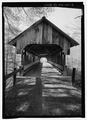
The Cornish–Windsor Covered Bridge is a 158-year-old, two-span, timber Town lattice-truss, interstate, covered bridge that crosses the Connecticut River between Cornish, New Hampshire, and Windsor, Vermont. Until 2008, when the Smolen–Gulf Bridge opened in Ohio, it had been the longest covered bridge in the United States.

The Columbia Bridge is a covered bridge, carrying Columbia Bridge Road over the Connecticut River between Columbia, New Hampshire and Lemington, Vermont. Built in 1911–12, it is one of only two New Hampshire bridges built with Howe trusses, and is one of the last covered bridges built in the historic era of covered bridge construction in both states. It was listed on the National Register of Historic Places in 1976.

The Mount Orne Bridge is a covered bridge over the Connecticut River between Lancaster, New Hampshire, and Lunenburg, Vermont. It joins Elm Street in South Lancaster with River Road in Lunenburg. Built in 1911, it is one of two Howe truss bridges across the Connecticut River. It was listed on the National Register of Historic Places in 1976.

The Bedell Bridge was a Burr truss covered bridge that spanned the Connecticut River between Newbury, Vermont and Haverhill, New Hampshire. Until its most recent destruction in 1979, it was, with a total length of 382 feet (116 m), the second-longest covered bridge in the United States. The bridge was divided into two spans of roughly equal length, and rested on a central pier and shore abutments constructed from mortared rough stone. The eastern abutment has been shored up by the addition of a concrete footing. The bridge was 23 feet (7.0 m) wide, with a roadway width of 18.5 feet (5.6 m). Because the state line is the western low-water mark of the Connecticut River, most of the bridge was in New Hampshire; only the western abutment is in Vermont.

The Sawyers Crossing Covered Bridge, also known as the Cresson Bridge, is a wooden covered bridge carrying Sawyers Crossing Road over the Ashuelot River in west Swanzey, New Hampshire. Built in 1859 to replace an older bridge, it continues to serve as a part of Swanzey's transportation network, and is one of the state's few surviving 19th-century covered bridges. It was listed on the National Register of Historic Places in 1978.

The Blow-Me-Down Covered Bridge is a historic wooden covered bridge carrying Lang Road over Blow-me-down Brook in the town of Cornish, near its northern border with Plainfield, New Hampshire. Built in 1877, the kingpost structure is one of the state's few surviving 19th-century covered bridges. The bridge was listed on the National Register of Historic Places in 1978.

The Whittier Bridge is a historic wooden covered bridge in Ossipee, New Hampshire. The bridge carried an old alignment of New Hampshire Route 25 over the Bearcamp River. Built in 1870, it is one of New Hampshire's few surviving 19th-century covered bridges, and a rare example of a Paddleford truss. The bridge was listed on the National Register of Historic Places in 1984. It was closed to vehicular traffic in 1989, and was removed from its footings for restoration in 2008. As of September 2019, the bridge is resting on Nudd Road adjacent to the crossing point. It was placed back on its abutments in the late fall of 2022.

The West Dummerston Covered Bridge is a historic covered bridge spanning the West River in Dummerston, Vermont, between Vermont Route 30 and Camp Arden Road. Built in 1872, it is at 280 feet (85 m) the longest covered bridge entirely within the state of Vermont. It was listed on the National Register of Historic Places in 1973.
The Bath Covered Bridge is a historic covered bridge over the Ammonoosuc River off US 302 and NH 10 in Bath, New Hampshire. Built in 1832, it is one of the state's oldest surviving covered bridges. It was listed on the National Register of Historic Places in 1976, and underwent a major rehabilitation in the 2010s.
The Haverhill–Bath Covered Bridge is a historic covered bridge over the Ammonoosuc River joining Bath and Woodsville, New Hampshire. Formerly used to carry New Hampshire Route 135, the bridge was idled in 1999. Restored in 2004, it is now open to foot traffic only. It is believed to be the oldest covered bridge in the state.

The Contoocook Railroad Bridge is a covered bridge on the former Contoocook Valley Railroad line spanning the Contoocook River in the center of the village of Contoocook, New Hampshire, United States. It is referred to in the National Register of Historic Places as the Hopkinton Railroad Covered Bridge, for the town of Hopkinton, New Hampshire, in which the village of Contoocook is located.

The Pine Brook Covered Bridge, also called the Wilder Covered Bridge, is a wooden covered bridge that crosses Pine Brook in Waitsfield, Vermont on North Road. Built in 1872, it is one two surviving 19th-century covered bridges in the town. It was listed on the National Register of Historic Places in 1974.

The Morgan Covered Bridge, also known as the Upper Covered Bridge is a wooden covered bridge that crosses the North Branch Lamoille River in Belvidere, Vermont on Morgan Bridge Road. Built about 1887, it is one of the two covered bridges in Belvidere, and one of five in a five-mile span that all cross the same river. It was listed on the National Register of Historic Places in 1974.

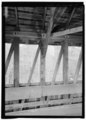
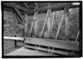
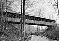
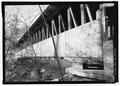
The Sulphite Railroad Bridge, also known locally as the Upside-Down Covered Bridge is a historic railroad bridge in Franklin, New Hampshire. The bridge was built circa 1896-7 to carry the tracks of the Boston and Maine Railroad across the Winnipesaukee River between Franklin and Tilton. The bridge is believed to be the only surviving "upside down" covered railroad bridge in the United States, in which the rail bed is laid on top of the bridge roof, whose purpose is to shelter the trusses below. The bridge was listed on the National Register of Historic Places in 1975. The bridge, unused since 1973, is not in good condition, having been subjected to graffiti, vandalism, and arson, as well as the elements.

The Corbin Covered Bridge is a wooden covered bridge over the North Branch of the Sugar River on Corbin Road, approximately 1 mile (1.6 km) west of NH 10 in Newport in Sullivan County, New Hampshire, United States. The bridge was listed on the National Register of Historic Places in 1976, but was removed following its destruction by fire in the early hours of May 25, 1993. It has since been reconstructed.
Wright's Bridge is a historic covered bridge in Newport, New Hampshire. Originally built in 1906 to carry the Boston and Maine Railroad across the Sugar River, it now carries the multi-use Sugar River Trail. The bridge was listed on the National Register of Historic Places in 1975.

The Dingleton Hill Covered Bridge, also known as the Cornish Mills Bridge, is a historic wooden covered bridge, carrying Root Hill Road over Mill Brook in Cornish Mills, New Hampshire. Built in 1882, it is one of the state's few surviving 19th-century covered bridges. It was listed on the National Register of Historic Places in 1978. It carries one lane of traffic, with a posted weight limit.

Best's Covered Bridge(akaSwallow's Bridge) is a historic covered bridge in West Windsor, Vermont, that carries Churchill Road over Mill Brook, just south of Vermont Route 44. Built in 1889, it is an architecturally distinctive laminated arch structure with a post-and-beam superstructure. It was listed on the National Register of Historic Places in 1973.

The East Shoreham Covered Railroad Bridge is a historic covered bridge spanning the Lemon Fair River near East Shoreham, Vermont. Built in 1897 by the Rutland Railroad Company, it is the state's only surviving example of a wooden Howe truss railroad bridge. It was listed on the National Register of Historic Places in 1974.

The Lyme–East Thetford Bridge is a historic bridge over the Connecticut River between Lyme, New Hampshire, and East Thetford, Vermont. From the New Hampshire side it carries East Thetford Road, which becomes Vermont Route 113 as it enters Vermont. A Parker truss bridge completed in 1937, it is 471 feet (144 m) long. The bridge was added to the National Register of Historic Places in 2020.