List of covered bridges in Vermont

Last updated

Below is a list of covered bridges in Vermont. There are just over 100 authentic covered bridges in the U.S. state of Vermont, giving the state the highest number of covered bridges per square mile in the United States. A covered bridge is considered authentic not due to its age, but by its construction. An authentic bridge is constructed using trusses rather than other methods such as stringers (a popular choice for non-authentic covered bridges).

Contents

List

NameCountyLocationBuiltLengthCrossesOwnershipTruss Type
Spade Farm Addison Ferrisburgh
44°14′15″N73°13′56″W / 44.237513°N 73.232095°W / 44.237513; -73.232095 (Spade Farm Covered Bridge)
185085'storm drainage ditchPrivate Town lattice
Pulp Mill [n 1] Addison Middlebury
44°01′29″N73°10′39″W / 44.024668°N 73.177485°W / 44.024668; -73.177485 (Pulp Mill Covered Bridge)
1820199' Otter Creek on Seymour StTowns Burr Arch
Halpin [n 2] Addison Middlebury
44°03′00″N73°08′27″W / 44.050136°N 73.140846°W / 44.050136; -73.140846 (Halpin Covered Bridge)
185066.2'Muddy Branch (of the New Haven River) on Halpin Covered Bridge RoadTown Town lattice
Rutland Railroad [n 3] Addison Shoreham
43°51′34″N73°15′21″W / 43.85933°N 73.255795°W / 43.85933; -73.255795 (Rutland Railroad Covered Bridge)
1897108' Richville Pond on an abandoned railroad bedVT State Division for Historic Preservation Howe truss
Paper Mill Bennington Bennington
42°54′46″N73°14′00″W / 42.912883°N 73.233393°W / 42.912883; -73.233393 (Paper Mill Covered Bridge)
1889131' Walloomsac River on Murphy RoadTown Town lattice
Silk Bennington Bennington
42°54′34″N73°13′31″W / 42.909512°N 73.225304°W / 42.909512; -73.225304 (Silk Covered Bridge)
184088' Walloomsac River on Silk RoadTown Town lattice
Henry Bennington Bennington
42°54′46″N73°15′17″W / 42.912643°N 73.254647°W / 42.912643; -73.254647 (Burt Henry Covered Bridge)
1840121' Walloomsac River on Murphy RoadTown Town lattice
Chiselville Bennington Sunderland
43°04′20″N73°07′59″W / 43.072215°N 73.133132°W / 43.072215; -73.133132 (Chiselville Covered Bridge)
1870117' Roaring Branch Brook on Sunderland Hill RoadTown Town lattice
West Arlington Bennington Arlington
43°06′16″N73°13′13″W / 43.104445°N 73.220315°W / 43.104445; -73.220315 (West Arlington Covered Bridge)
185280' Batten Kill on Covered Bridge RoadTown Town lattice
Greenbanks Hollow Caledonia Danville
44°22′39″N72°07′19″W / 44.377628°N 72.122004°W / 44.377628; -72.122004 (Greenbanks Hollow Covered Bridge)
188674' Joe's Brook on Greenbanks Hollow RoadTown Queen post
Schoolhouse [n 4] Caledonia Lyndon
44°30′58″N72°00′37″W / 44.516174°N 72.010145°W / 44.516174; -72.010145 (Schoolhouse Covered Bridge)
187942'South Wheelock Branch of Passumpsic River on Wheelock RoadTown(?) Queen post
Chamberlin Caledonia Lyndon
44°31′00″N72°00′59″W / 44.51659°N 72.01647°W / 44.51659; -72.01647 (Chamberlin Covered Bridge)
188166'South Wheelock Branch of Passumpsic River on Chamberlin Bridge RoadTown(?) Queen post
Sanborn [n 5] Caledonia Lyndon
44°32′39″N72°00′03″W / 44.544304°N 72.000875°W / 44.544304; -72.000875 (Sanborn Covered Bridge)
1867117' Passumpsic River Private Paddleford Truss
Millers Run Caledonia Lyndon
44°32′32″N72°00′36″W / 44.542201°N 72.009898°W / 44.542201; -72.009898 (Millers Run Covered Bridge)
187856'Millers Run on Center StreetTown(?) Queen post
Old Burrington [n 6] Caledonia Lyndon
44°33′13″N71°58′10″W / 44.553644°N 71.969515°W / 44.553644; -71.969515 (Old Burrington Covered Bridge)
186568'East Branch of Passumpsic River on Burrington Bridge RoadPrivate Queen post
Holmes Creek Chittenden Charlotte
44°19′59″N73°16′56″W / 44.333123°N 73.282301°W / 44.333123; -73.282301 (Holmes Creek Covered Bridge)
187041'Holmes Creek on Lake RoadTown King Post with tied arch
Seguin (or Sequin) Chittenden Charlotte
44°17′21″N73°09′01″W / 44.289068°N 73.15032°W / 44.289068; -73.15032 (Seguin Covered Bridge)
185070'Lewis Creek on Roscoe RoadTown Burr Arch
Quinlan's Chittenden Charlotte
44°16′35″N73°11′02″W / 44.27641°N 73.18388°W / 44.27641; -73.18388 (Quinlan's Covered Bridge)
184986'Lewis Creek on Monkton RoadTown Burr Arch
Browns River [n 7] Chittenden Westford
44°36′45″N73°00′29″W / 44.61259°N 73.008088°W / 44.61259; -73.008088 (Browns River Covered Bridge)
183797' Browns River on Cambridge RoadTown Burr arch
Browns River Closed to motor traffic. Chittenden Jericho
44°30′59″N72°56′48″W / 44.516404°N 72.946590°W / 44.516404; -72.946590 (Mills Riverside Covered Bridge)
1967 [1] Unknown Length Browns River at Mills Riverside ParkLand-Trust Burr arch
Shelburne Museum [n 8] Chittenden Shelburne
44°22′37″N73°13′46″W / 44.377002°N 73.229527°W / 44.377002; -73.229527 (Shelburne Museum Covered Bridge)
1845168'Burr Pond on grounds of Shelburne MuseumPrivate Burr arch
Columbia [n 9] Essex Lemington
44°51′12″N71°33′06″W / 44.853245°N 71.551691°W / 44.853245; -71.551691 (Columbia Covered Bridge)
1912146' Connecticut River on Columbia Bridge RoadTown Howe truss
Mount Orne [n 10] Essex Lunenburg
44°27′37″N71°39′10″W / 44.460243°N 71.652709°W / 44.460243; -71.652709 (Mount Orne Covered Bridge)
1911266' Connecticut River on Mount Orne Bridge RoadTown Howe truss
Island Pond Footbridge [n 11] Essex Island Pond
44°48′59″N71°52′52″W / 44.816295°N 71.88105°W / 44.816295; -71.88105 (Island Pond Covered Footbridge)
2003242'railroad tracksTown(?) Howe truss
Hopkins Franklin Enosburg
44°55′14″N72°40′23″W / 44.92062°N 72.673096°W / 44.92062; -72.673096 (Hopkins Covered Bridge)
187584' Trout River on Hopkins Bridge RoadTown Town lattice
Maple Street Franklin Fairfax
44°39′49″N73°00′38″W / 44.663697°N 73.010432°W / 44.663697; -73.010432 (Maple Street Covered Bridge)
186557'Mill Brook on Maple StreetTown Town lattice
East Fairfield Franklin Fairfield
44°47′10″N72°51′44″W / 44.78616°N 72.862294°W / 44.78616; -72.862294 (East Fairfield Covered Bridge)
186567'Black Creek on Covered Bridge RoadTown Queen post
Comstock Franklin Montgomery
44°53′59″N72°38′41″W / 44.899637°N 72.644842°W / 44.899637; -72.644842 (Comstock Covered Bridge)
188369' Trout River on Comstock Bridge RoadTown Town lattice
West Hill Franklin Montgomery
44°52′03″N72°38′54″W / 44.867626°N 72.648318°W / 44.867626; -72.648318 (West Hill Covered Bridge)
188359'West Hill Brook on Creamery Bridge RoadTown Town lattice
Fuller Franklin Montgomery
44°54′12″N72°38′24″W / 44.903349°N 72.640116°W / 44.903349; -72.640116 (Fuller Covered Bridge)
189050'Black Falls Brook on South Richford RoadTown Town lattice
Hectorville [n 12] Franklin Montgomery
44°51′14″N72°36′49″W / 44.853781°N 72.613599°W / 44.853781; -72.613599 (Hectorville Covered Bridge)
188354'South Branch of Trout River on Gibou RoadTown Town lattice and King post
Hutchins Franklin Montgomery
44°51′31″N72°36′45″W / 44.858628°N 72.612551°W / 44.858628; -72.612551 (Hutchins Covered Bridge)
188354'South Branch of Trout River on Hutchins Bridge RoadTown Town lattice
Longley Franklin Montgomery
44°54′26″N72°39′21″W / 44.90723°N 72.655946°W / 44.90723; -72.655946 (Longley Covered Bridge)
186385' Trout River on Longley Bridge RoadTown Town lattice
Grist Mill Lamoille Cambridge
44°38′12″N72°49′31″W / 44.636689°N 72.82537°W / 44.636689; -72.82537 (Grist Mill Covered Bridge)
187285' Brewster River on Canyon RoadTown Burr arch
Poland Lamoille Cambridge
44°39′05″N72°48′53″W / 44.651343°N 72.81465°W / 44.651343; -72.81465 (Poland Covered Bridge)
1887153' Lamoille River on Cambridge Junction RoadTown Burr arch
Gates Farm Lamoille Cambridge
44°38′45″N72°52′20″W / 44.645773°N 72.872314°W / 44.645773; -72.872314 (Gates Farm Covered Bridge)
189760' Seymour River on farm access roadPrivate Burr arch
Mill Lamoille Belvidere
44°44′37″N72°44′29″W / 44.743731°N 72.741433°W / 44.743731; -72.741433 (Mill Covered Bridge)
189571'North Branch of Lamoille River on Back RoadTown Queen post
Morgan Lamoille Belvidere
44°44′37″N72°43′41″W / 44.743575°N 72.728097°W / 44.743575; -72.728097 (Morgan Covered Bridge)
188762'North Branch of Lamoille River on Morgan Bridge RoadTown Queen post
Power House Lamoille Johnson
44°38′10″N72°40′13″W / 44.636118°N 72.670414°W / 44.636118; -72.670414 (Power House Covered Bridge)
187263' Gihon River on School StreetTown Queen post
Scribner Lamoille Johnson
44°38′18″N72°38′55″W / 44.638227°N 72.648559°W / 44.638227; -72.648559 (Scribner Covered Bridge)
 ?48' Gihon River on Rocky RoadTown Queen post
Red Lamoille Morristown
44°31′07″N72°40′40″W / 44.518698°N 72.67772°W / 44.518698; -72.67772 (Red Covered Bridge)
189664'Sterling Brook on Cole Hill RoadTown King post and Queen post
Emily's [n 13] Lamoille Stowe
44°26′26″N72°40′47″W / 44.440483°N 72.679831°W / 44.440483; -72.679831 (Emily's Covered Bridge)
184449'Gold Brook on Covered Bridge RoadTown Queen post
Village Lamoille Waterville
44°41′25″N72°46′16″W / 44.690151°N 72.770983°W / 44.690151; -72.770983 (Village Covered Bridge)
187761'North Branch of Lamoille River on Church StreetTown Queen post
Montgomery Lamoille Waterville
44°42′21″N72°45′37″W / 44.705735°N 72.760236°W / 44.705735; -72.760236 (Montgomery Covered Bridge)
187770'North Branch of Lamoille River on Montgomery RoadTown Queen post
Codding Hollow Lamoille Waterville
44°42′44″N72°45′22″W / 44.712167°N 72.756247°W / 44.712167; -72.756247 (Codding Hollow Covered Bridge)
187762'North Branch of Lamoille River on Codding Hollow RoadTown Queen post
Fisher Railroad Lamoille Wolcott
44°31′57″N72°25′40″W / 44.532487°N 72.427832°W / 44.532487; -72.427832 (Fisher Railroad Covered Bridge)
190898' Lamoille River on Railroad line State of Vermont Double Web Town lattice with steel deck supports
Moxley Orange Chelsea
43°57′25″N72°27′48″W / 43.957032°N 72.463401°W / 43.957032; -72.463401 (Moxley Covered Bridge)
188356'First Branch of White River on Moxley RoadTown Queen post
Kingsbury Orange Randolph
43°52′51″N72°34′55″W / 43.880859°N 72.582008°W / 43.880859; -72.582008 (Kingsbury Covered Bridge)
190446'Second Branch of White River on Kingsbury RoadTownmultiple King post
Gifford Orange Randolph
43°54′59″N72°33′18″W / 43.916258°N 72.555052°W / 43.916258; -72.555052 (Gifford Covered Bridge)
190446'Second Branch of White River on Hyde RoadTownmultiple King post
Braley Orange Randolph
43°55′43″N72°33′18″W / 43.928528°N 72.555098°W / 43.928528; -72.555098 (Braley Covered Bridge)
190438'Second Branch of White River on Braley Covered Bridge RoadTownmultiple King post
Union Village Orange Thetford
43°47′19″N72°15′15″W / 43.788728°N 72.254071°W / 43.788728; -72.254071 (Union Village Covered Bridge)
1867111' Ompompanoosuc River on Academy RoadTownmultiple King post variation
Sayres Orange Thetford
43°49′56″N72°15′10″W / 43.832139°N 72.25278°W / 43.832139; -72.25278 (Sayres Covered Bridge)
 ?127' Ompompanoosuc River on Tucker Hill RoadTown Haupt truss variant with arch
Howe Orange Tunbridge
43°51′54″N72°29′57″W / 43.864938°N 72.499031°W / 43.864938; -72.499031 (Howe Covered Bridge)
187975'First Branch of White River on Belnap Brook RoadTownmultiple King post
Cilley Orange Tunbridge
43°52′59″N72°30′14″W / 43.883036°N 72.5039°W / 43.883036; -72.5039 (Cilley Covered Bridge)
188368'First Branch of White River on Howe LaneTownmultiple King post
Mill Orange Tunbridge
43°53′31″N72°29′30″W / 43.891827°N 72.49158°W / 43.891827; -72.49158 (Mill Covered Bridge)
1883; replicated in 200076'First Branch of White River on Spring RoadTownmultiple King post
Larkin Orange Tunbridge
43°55′23″N72°27′56″W / 43.923065°N 72.465506°W / 43.923065; -72.465506 (Larkin Covered Bridge)
190268'First Branch of White River on Larkin RoadTownmultiple King post
Flint Orange Tunbridge
43°56′58″N72°27′31″W / 43.949368°N 72.458621°W / 43.949368; -72.458621 (Flint Covered Bridge)
184587'First Branch of White River on Bicknell Hill RoadTown Queen post
Lord's Creek Orleans Irasburg
44°49′00″N72°15′59″W / 44.816565°N 72.266487°W / 44.816565; -72.266487 (Lord's Creek Covered Bridge)
188150' Black River on Covered Bridge RoadPrivate Paddleford truss
Black River Orleans Irasburg
44°51′40″N72°16′24″W / 44.860981°N 72.273321°W / 44.860981; -72.273321 (Black River Covered Bridge)
188187' Black River on Hermanville RoadTown Paddleford truss
Depot Rutland Pittsford
43°42′34″N73°02′34″W / 43.709567°N 73.04268°W / 43.709567; -73.04268 (Depot Covered Bridge)
1853126' Otter Creek on Depot Hill RoadTown Town lattice
Cooley Rutland Pittsford
43°41′26″N73°01′43″W / 43.690459°N 73.028583°W / 43.690459; -73.028583 (Cooley Covered Bridge)
184951' Furnace Brook on Elm StreetTown Town lattice
Hammond [n 14] Rutland Pittsford
43°43′15″N73°03′13″W / 43.720703°N 73.053562°W / 43.720703; -73.053562 (Hammond Covered Bridge)
1843145' Otter Creek next to Kendall Hill RoadVT Division for Historic Preservation Town lattice
Gorham Rutland Pittsford
43°40′48″N73°02′15″W / 43.680041°N 73.037539°W / 43.680041; -73.037539 (Gorham Covered Bridge)
1842115' Otter Creek on Gorham Bridge RoadTown Town lattice
Sanderson Rutland Brandon
43°47′23″N73°06′42″W / 43.789661°N 73.111761°W / 43.789661; -73.111761 (Sanderson Covered Bridge)
1840132' Otter Creek on Pearl St ExtensionTown Town lattice
Kingsley Rutland Clarendon
43°31′26″N72°56′28″W / 43.523869°N 72.941065°W / 43.523869; -72.941065 (Kingsley Covered Bridge)
1870121' Mill River on East StreetTown Town lattice
Brown Rutland Shrewsbury
43°33′59″N72°55′08″W / 43.566326°N 72.918915°W / 43.566326; -72.918915 (Brown Covered Bridge)
1880112' Cold River on Upper Cold River RdTown Town lattice
Twin [n 15] Rutland Rutland
43°38′55″N72°58′22″W / 43.648645°N 72.972672°W / 43.648645; -72.972672 (Twin Covered Bridge)
185060'dry landTown Town lattice
Coburn Washington East Montpelier
44°16′51″N72°27′15″W / 44.280848°N 72.454198°W / 44.280848; -72.454198 (Coburn Covered Bridge)
1840s69' Winooski River on Coburn RoadTown Queen post
Orton Farm [n 16] Washington Marshfield
44°17′15″N72°24′29″W / 44.287567°N 72.40818°W / 44.287567; -72.40818 (Martin Covered Bridge)
189045' Winooski River on a farm access roadTown Queen post
Stony Brook Washington Northfield
44°07′13″N72°41′21″W / 44.120409°N 72.689189°W / 44.120409; -72.689189 (Stony Brook Covered Bridge)
189937' Stony Brook on Stony Brook RoadTown King post
Northfield Falls Washington Northfield
44°10′21″N72°39′05″W / 44.172491°N 72.651469°W / 44.172491; -72.651469 (Northfield Falls Covered Bridge)
1872137' Dog River on Cox Brook RoadTown Town lattice
Slaughter House Washington Northfield
44°10′07″N72°39′16″W / 44.168569°N 72.65457°W / 44.168569; -72.65457 (Slaughter House Covered Bridge)
187260' Dog River on Slaughterhouse RoadTown Queen post
Lower Cox Brook Washington Northfield
44°10′22″N72°39′11″W / 44.172788°N 72.653039°W / 44.172788; -72.653039 (Lower Cox Brook Covered Bridge)
187257'Cox Brook on Cox Brook RoadTown Queen post
Upper Cox Brook Washington Northfield
44°10′26″N72°39′20″W / 44.173809°N 72.655565°W / 44.173809; -72.655565 (Upper Cox Brook Covered Bridge)
187252'Cox Brook on Cox Brook RoadTown Queen post
Pine Brook Washington Waitsfield
44°12′20″N72°47′32″W / 44.205639°N 72.792132°W / 44.205639; -72.792132 (Pine Brook Covered Bridge)
187248'Pine Brook on North RoadTown King post
Great Eddy Washington Waitsfield
44°11′22″N72°49′25″W / 44.189497°N 72.823608°W / 44.189497; -72.823608 (Great Eddy Covered Bridge)
1833105' Mad River on Bridge StreetTown Burr arch
Warren Washington Warren
44°06′40″N72°51′25″W / 44.111185°N 72.857037°W / 44.111185; -72.857037 (Warren Covered Bridge)
188055' Mad River on Covered Bridge RoadTown Queen post
Robbins Nest [n 17] Washington Barre
44°10′43″N72°28′15″W / 44.178703°N 72.470833°W / 44.178703; -72.470833 (Robbins Nest Covered Bridge)
186457'Jail Branch of Winooski River on private drivePrivate Queen post
Kent's Corner Washington Calais
44°22′04″N72°29′03″W / 44.367867°N 72.484287°W / 44.367867; -72.484287 (Kent's Corner Covered Footbridge)
196322'Curtis Brook on homestead pathPrivate King post
AM Foster [n 18] Washington Cabot
44°25′25″N72°16′06″W / 44.423546°N 72.268453°W / 44.423546; -72.268453 (AM Foster Covered Bridge)
198840'pondPrivate Queen post
Creamery [n 19] Windham Brattleboro
42°51′00″N72°35′08″W / 42.849905°N 72.585664°W / 42.849905; -72.585664 (Creamery Covered Bridge)
187980' Whetstone Brook at Guilford StreetTown Town lattice
West Dummerston [n 20] Windham West Dummerston
42°56′12″N72°36′46″W / 42.936654°N 72.612757°W / 42.936654; -72.612757 (West Dummerston Covered Bridge)
1872280' West River on Covered Bridge RoadTown Town lattice
Kidder Hill Windham Grafton
43°10′09″N72°36′20″W / 43.169194°N 72.605459°W / 43.169194; -72.605459 (Kidder Hill Covered Bridge)
187067'South Branch of Saxtons River on Kidder Hill RoadTownModified King post
Green River Windham Guilford
42°46′32″N72°40′02″W / 42.775523°N 72.667238°W / 42.775523; -72.667238 (Green River Covered Bridge)
1870104' Green River at Jacksonville Stage RoadTown Town lattice
Williamsville Windham Newfane
42°56′35″N72°41′13″W / 42.943012°N 72.686848°W / 42.943012; -72.686848 (Williamsville Covered Bridge)
1870118' Rock River at Dover RoadTown Town lattice
Hall [n 21] Windham Rockingham
43°08′15″N72°29′14″W / 43.137494°N 72.487243°W / 43.137494; -72.487243 (Hall Covered Bridge)
1870121' Saxtons River Hall Bridge RoadTown Town lattice
Victorian Village [2] [n 22] Windham Rockingham
43°11′49″N72°30′15″W / 43.196894°N 72.50412°W / 43.196894; -72.50412 (Victorian Village Covered Bridge)
187244'Rock Brook at the Vermont Country Store PrivateModified King post
Worrall Bridge Windham Rockingham
43°12′43″N72°32′08″W / 43.211831°N 72.535558°W / 43.211831; -72.535558 (Worrall Covered Bridge)
187083' Williams River on Williams RoadTown Town lattice
Scott [n 23] Windham Townshend
43°02′55″N72°41′47″W / 43.048745°N 72.696388°W / 43.048745; -72.696388 (Scott Covered Bridge)
1870276' West River on Back Side RoadTown Town lattice with added arch with Howe truss metal rods for verticals
High Mowing Windham Wilmington
42°53′03″N72°50′55″W / 42.884085°N 72.848577°W / 42.884085; -72.848577 (High Mowing Farm Covered Bridge)
194921'Stowe BrookPrivate Town lattice
Johnny Esau [n 24] Windham Marlboro
42°52′09″N72°43′11″W / 42.869226°N 72.719675°W / 42.869226; -72.719675 (Johnny Esau Covered Footbridge)
200415'Unknown brookTown(?) Town lattice
Hitchcock-Cormier Windham Rockingham
43°09′41″N72°33′06″W / 43.161488°N 72.55163°W / 43.161488; -72.55163 (Hitchcock-Cormier Covered Footbridge)
200822'Unknown brook ? Town lattice
Bartonsville [2] [n 25] Windham Rockingham
43°13′27″N72°32′12″W / 43.224231°N 72.536792°W / 43.224231; -72.536792 (Bartonsville Covered Bridge)
2012168' Williams River  ? Town lattice
Baltimore [n 26] Windsor Springfield
43°16′13″N72°26′54″W / 43.270319°N 72.448252°W / 43.270319; -72.448252 (Baltimore Covered Bridge)
187047'dry landTown Town lattice
Stoughton [n 27] Windsor Weathersfield
43°22′07″N72°30′59″W / 43.36853°N 72.516466°W / 43.36853; -72.516466 (Stoughton Covered Footbridge)
188048' Schoolhouse Brook PrivateMultiple King post
Salmond Windsor Weathersfield
43°25′37″N72°29′18″W / 43.426849°N 72.488388°W / 43.426849; -72.488388 (Salmond Covered Bridge)
187553' Sherman Brook on Henry Gould RoadTownMultiple King post
Upper Falls Windsor Weathersfield
43°23′55″N72°31′19″W / 43.398687°N 72.522072°W / 43.398687; -72.522072 (Upper Falls Covered Bridge)
1840120' Black River on Upper Falls RoadTown Town lattice
Bests Windsor West Windsor
43°27′19″N72°30′59″W / 43.455201°N 72.516396°W / 43.455201; -72.516396 (Bests Covered Bridge)
188937' Mill Brook on Churchill RoadTown Tied arch
Bowers Windsor West Windsor
43°27′41″N72°29′27″W / 43.461416°N 72.490727°W / 43.461416; -72.490727 (Bowers Covered Bridge)
191945' Mill Brook on Bowers RoadTown Tied arch
Taftsville Windsor Taftsville
43°37′52″N72°28′04″W / 43.631102°N 72.467725°W / 43.631102; -72.467725 (Taftsville Covered Bridge)
1836189' Ottauquechee River on River RoadTownMultiple King post and arch
Lincoln Windsor Woodstock
43°36′03″N72°34′08″W / 43.600768°N 72.568868°W / 43.600768; -72.568868 (Lincoln Covered Bridge)
1877136' Ottauquechee River on Fletcher Hill RoadTown Pratt truss with arch
Union Street Windsor Woodstock
43°37′29″N72°31′14″W / 43.624745°N 72.520452°W / 43.624745; -72.520452 (Middle Covered Bridge)
1969139' Ottauquechee River on Mountain AveTown Town lattice
South Pomfret Windsor Pomfret
43°39′41″N72°32′16″W / 43.661255°N 72.537677°W / 43.661255; -72.537677 (South Pomfret Covered Bridge)
187039'Barnard Brook on private lanePrivate Town lattice
Martins Mill Windsor Hartland
43°31′57″N72°23′45″W / 43.5325°N 72.395949°W / 43.5325; -72.395949 (Martin's Mill Covered Bridge)
1881135' Lulls Brook on Martinsville RoadTown Town lattice
Willard Windsor Hartland
43°35′38″N72°20′58″W / 43.59387°N 72.349455°W / 43.59387; -72.349455 (Willard Covered Bridge)
1870125' Ottauquechee River on Mill StreetTown Town lattice
(Willard) Twin [n 28] Windsor Hartland
43°35′37″N72°21′01″W / 43.593687°N 72.350158°W / 43.593687; -72.350158 (Willard Twin Covered Bridge)
200181' Ottauquechee River on Mill StreetTown Town lattice
Windsor-Cornish [n 29] Windsor Windsor
43°28′26″N72°23′02″W / 43.47382°N 72.383981°W / 43.47382; -72.383981 (Cornish-Windsor Covered Bridge)
1866449' Connecticut River on Bridge Street New Hampshire Department of Transportation Town lattice
Ledoux Hometown [n 30] Windsor Reading
43°27′10″N72°32′07″W / 43.452783°N 72.535354°W / 43.452783; -72.535354 (Ledoux Hometown Covered Footbridge)
200815'seasonal brookPrivate Town lattice

Destroyed

See also

Map all coordinates using: OpenStreetMap  
Download coordinates as: KML

Notes

  1. A rare two lane covered bridge.
  2. Highest covered bridge from its waterway in Vermont.
  3. This bridge is one of two remaining rail road covered bridges in the state of Vermont.
  4. Closed to motor traffic.
  5. Closed to motor traffic.
  6. Closed to motor traffic.
  7. Closed to motor traffic.
  8. Closed to motor traffic.
  9. This bridge is mostly in New Hampshire, due to the state line being the western edge of the river.
  10. This bridge is mostly in New Hampshire as the state line is the western edge of the river. Closed to traffic as of May 26, 2010. (see Article: "Mt. Orne Bridge Repairs Completed")
  11. The length of the truss section is 112'. Overall length includes post and beam staircases on both ends.
  12. This bridge was dismantled and stored in 2002. It is included on the list because there are reportedly plans to rebuild it (see Article: "Montgomery's Hectorville Bridge Project")
  13. Reportedly haunted!
  14. Closed to vehicle traffic (bypassed).
  15. This bridge is now on dry land, and boarded up. It is being used as a storage shed by the Town of Rutland Highway Department.
  16. Last authentic covered bridge left in Vermont that was built for agricultural use.
  17. Replica of Old Bridge which was located just downstream.
  18. Replica of Orton Farm Bridge
  19. Bypassed in 2010. (see: Article: "Brattleboro's Creamery Bridge By-pass Project Status")
  20. This is the longest covered bridge completely within Vermont borders.
  21. Replaced in 1982 with a bridge of similar design, after a truck broke the old bridge in 1980. See "Around Bellows Falls: Rockingham, Westminster, and Saxtons River" By Anne L. Collins, Virginia Lisai, and Louise Luring. Arcadia Publishing, 2002. ISBN   978-0-7385-1033-0, page 127. Parts of the old bridge are on display outside the Saxtons River Cemetery on Westminster St.
  22. Also called Depot Covered Bridge.
  23. This bridge has the longest single span in the state of Vermont, at 166'.
  24. At Marlboro Elementary School. Built by school students and modeled after the Silk Covered Bridge
  25. Replaced a bridge built in 1870 and destroyed by flooding in 2011.
  26. At Eureka Schoolhouse Park... closed to motor traffic.
  27. In a field across from Weathersfield Elementary School. Owners welcome visitors. No motor traffic.
  28. Located a few yards south of Willard Bridge. Replaces a Covered Bridge previously at this location prior to 1938.
  29. This bridge is mostly in New Hampshire, due to the state line being the western edge of the river. Longest wooden bridge in the United States. Longest two span covered bridge in the world
  30. At the entrance to a Nature and Fitness trail, near the Elementary School.

Related Research Articles

Covered bridge Wooden bridge with protective cover

A covered bridge is a timber-truss bridge with a roof, decking, and siding, which in most covered bridges create an almost complete enclosure. The purpose of the covering is to protect the wooden structural members from the weather. Uncovered wooden bridges typically have a lifespan of only 20 years because of the effects of rain and sun, but a covered bridge could last over 100 years. In the United States, only about 1 in 10 survived the 20th century. The relatively small number of surviving bridges is due to deliberate replacement, neglect, and the high cost of restoration.

Bartonsville Covered Bridge United States historic place

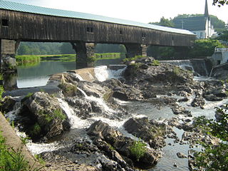
The Bartonsville Covered Bridge is a wooden covered bridge in the village of Bartonsville, in Rockingham, Vermont, United States. The bridge is a lattice truss style with a 151-foot span, carrying Lower Bartonsville Road over the Williams River. It was built in 2012, replacing a similar bridge built in 1870 by Sanford Granger. The 1870 bridge, which was listed on the National Register of Historic Places, was destroyed in 2011 in flooding caused by Hurricane Irene.

Whites Bridge Bridge in Smyrna, Michigan

Whites Bridge is a 120-foot-long (37 m) Brown truss covered bridge, originally erected in 1869 in Keene Township, Michigan, United States, near Smyrna on the Flat River. Carrying Whites Bridge Road across the Flat River, it is located north of the Fallasburg Bridge and south of Smyrna. The original bridge was among the area's best-known 19th century structures. The bridge was completely destroyed by fire, on the morning of July 7, 2013. In July 2016, approval was granted for rebuilding a replica bridge, which was completed in April 2020.

Cornish–Windsor Covered Bridge Bridge in New Hampshire to Windsor, Vermont

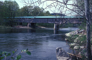
The Cornish–Windsor Covered Bridge is a 156-year-old, two-span, timber Town lattice-truss, interstate, covered bridge that crosses the Connecticut River between Cornish, New Hampshire, and Windsor, Vermont. Until 2008, when the Smolen–Gulf Bridge opened in Ohio, it had been the longest covered bridge in the United States.

Columbia Bridge (Connecticut River) Bridge in New Hampshire and Lemington, Vermont

The Columbia Bridge is a covered bridge, carrying Columbia Bridge Road over the Connecticut River between Columbia, New Hampshire and Lemington, Vermont. Built in 1911–12, it is one of only two New Hampshire bridges built with Howe trusses, and is one of the last covered bridges built in the historic era of covered bridge construction in both states. It was listed on the National Register of Historic Places in 1976.

Bedell Covered Bridge Bridge in Vermont and Haverhill, New Hampshire

The Bedell Bridge was a Burr truss covered bridge that spanned the Connecticut River between Newbury, Vermont and Haverhill, New Hampshire. Until its most recent destruction in 1979, it was, with a total length of 382 feet (116 m), the second-longest covered bridge in the United States. The bridge was divided into two spans of roughly equal length, and rested on a central pier and shore abutments constructed from mortared rough stone. The eastern abutment has been shored up by the addition of a concrete footing. The bridge was 23 feet (7.0 m) wide, with a roadway width of 18.5 feet (5.6 m). Because the state line is the western low-water mark of the Connecticut River, most of the bridge was in New Hampshire; only the western abutment is in Vermont.

Old Blenheim Bridge Wooden covered bridge that spanned Schoharie Creek in North Blenheim, New York, United States

Old Blenheim Bridge was a wooden covered bridge that spanned Schoharie Creek in North Blenheim, New York, United States. With an open span of 210 feet (64 m), it had the second longest span of any surviving single-span covered bridge in the world. The 1862 Bridgeport Covered Bridge in Nevada County, California, currently undergoing repairs due to 1986 flooding is longer overall at 233 feet (71 m) but is argued to have a 208 feet (63 m) clear span. The bridge, opened in 1855, was also one of the oldest of its type in the United States. It was destroyed by flooding resulting from Tropical Storm Irene in 2011. Rebuilding of the bridge commenced in 2017 and was completed in 2018.

Arch Bridge (Bellows Falls) Bridge in Vermont to North Walpole, New Hampshire

The Bellows Falls Arch Bridge was a three-hinged steel through arch bridge over the Connecticut River between Bellows Falls, Vermont and North Walpole, New Hampshire. It was structurally significant as the longest arch bridge in the United States when it was completed in 1905.

Bath Covered Bridge United States historic place

The Bath Covered Bridge is a historic covered bridge over the Ammonoosuc River off US 302 and NH 10 in Bath, New Hampshire. Built in 1832, it is one of the state's oldest surviving covered bridges. It was listed on the National Register of Historic Places in 1976, and underwent a major rehabilitation in the 2010s.

Contoocook Railroad Bridge United States historic place

The Contoocook Railroad Bridge is a covered bridge on the former Contoocook Valley Railroad line spanning the Contoocook River in the center of the village of Contoocook, New Hampshire, United States. It is referred to in the National Register of Historic Places as the Hopkinton Railroad Covered Bridge, for the town of Hopkinton, New Hampshire, in which the village of Contoocook is located.

Great Eddy Covered Bridge Bridge in Waitsfield, Vermont

The Great Eddy Covered Bridge, also called the Big Eddy Covered Bridge or Waitsfield Covered Bridge, is a wooden covered bridge that crosses the Mad River in Waitsfield, Vermont on Bridge Street. Built in 1833, it is one of Vermont's oldest covered bridges. It was listed on the National Register of Historic Places in 1974.

Longley Covered Bridge Bridge in Montgomery, Vermont

The Longley Covered Bridge, also known as the Harnois Covered Bridge, is a wooden covered bridge that crosses the Trout River in Montgomery, Vermont on Longley Bridge Road. Built in 1863, this Town lattice truss bridge is the oldest of a group of area bridges built by brothers Sheldon & Savannah Jewett. It was listed on the National Register of Historic Places in 1974. The bridge is closed to traffic, and has been bypassed by an adjacent temporary bridge.

Hammond Covered Bridge United States historic place

The Hammond Covered Bridge is a Town lattice covered bridge spanning Otter Creek in Pittsford, Vermont. The bridge was built in 1842 by Asa Norse, and originally carried Kendall Hill Road, which now passes just to its south. The bridge was added to the National Register of Historic Places on January 21, 1974.

Hall Covered Bridge United States historic place

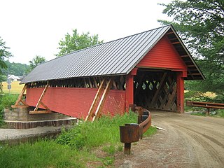
The Hall Covered Bridge, located in southern Rockingham, Vermont, carries Hall Bridge Road across the Saxtons River, just north of its junction with Vermont Route 121. It is a Town lattice truss bridge, built in 1982 as a replica of a circa-1867 bridge that was destroyed by an overweight truck in 1980. The bridge was listed on the National Register of Historic Places in 1973.

Scott Covered Bridge (Townshend, Vermont) United States historic place

Scott Covered Bridge is a covered bridge spanning the West River in Townshend, Vermont. Built in 1870, it is at 277 feet (84 m) one of the longest covered bridges in the state, exhibiting three different forms of support: a Town lattice truss, kingpost trusses, and laminated arches. The bridge was listed on the National Register of Historic Places in 1973. It is closed to all traffic.

Centre Covered Bridge United States historic place

The Centre Covered Bridge, also known as the Sanborn Covered Bridge, is a historic covered bridge, spanning the Passumpsic River next to U.S. Route 5 (US 5) north of the village of Lyndonville, Vermont. Built in 1872, it was moved to its present location and taken out of service in 1960. It is one of three surviving Paddle-Ford truss bridges in Vermont. It was listed on the National Register of Historic Places in 1974.

West Milton Bridge United States historic place

The West Milton Bridge is a steel girder bridge carrying Bear Trap Road across the Lamoille River in Milton, Vermont, United States. It was built as a replacement for a 1902 Pennsylvania truss bridge, which was relocated to the site of the Swanton Covered Railroad Bridge, and is listed on the National Register of Historic Places.

River Road Covered Bridge United States historic place

The River Road Covered Bridge was a historic covered bridge, carrying Veilleux Road across the Missisquoi River in Troy, Vermont. Built in 1910, the Town lattice truss was the only surviving covered bridge in Troy from the historic period of covered bridge construction when it burned on February 6, 2021. It also exhibited some distinctive variations in construction from more typical Town lattices. It was listed on the National Register of Historic Places in 1974.

Lyme–East Thetford Bridge United States historic place

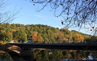
The Lyme–East Thetford Bridge is a historic bridge over the Connecticut River between Lyme, New Hampshire, and East Thetford, Vermont. From the New Hampshire side it carries East Thetford Road, which becomes Vermont Route 113 as it enters Vermont. A Parker truss bridge completed in 1937, it is 471 feet (144 m) long. The bridge was added to the National Register of Historic Places in 2020.

References

  1. "History of the Covered Bridge". Mills Riverside Park. Jericho Underhill Park District. Retrieved 31 August 2022.
  2. 1 2 Caswell, William S. World Guide to Covered Bridges (2021 ed.). Concord, New Hampshire: National Society for the Preservation of Covered Bridges. pp. 137–154. ISBN   978-0-578-30263-8.
  3. WCAX News Team (6 February 2021). "Landmark covered bridge in Troy collapses from fire damage". WCAX. Gray Television, Inc. Retrieved 6 February 2021.