List of covered bridges in New Hampshire

Last updated

This is a list of New Hampshire covered bridges, old, new, and restored. There are 58 historic wooden covered bridges currently standing and assigned official numbers by the U.S. state of New Hampshire. [1] There are additional covered bridges extant in the state, some of which are on private property and not accessible to the public. The newest covered bridge known to have been constructed in the state is Chester's Wason Bridge, built in 2011 by the Timber Framers Guild. [2]

Contents

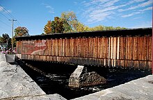
Standing covered bridges

A map of numbered covered bridges in New Hampshire, 1967 Nh covered bridge map display 1967.jpg
A map of numbered covered bridges in New Hampshire, 1967
Stark Covered Bridge, built in 1857, over the Upper Ammonoosuc River UpperAmmonoosuc.jpg
Stark Covered Bridge, built in 1857, over the Upper Ammonoosuc River
Contoocook Railroad Bridge is the oldest covered railroad bridge of its kind in the United States Contoocook Covered Railroad Bridge.JPG
Contoocook Railroad Bridge is the oldest covered railroad bridge of its kind in the United States
Conway is home to the Saco River Bridge, built in 1890 Saco River Bridge (Conway, New Hampshire).jpg
Conway is home to the Saco River Bridge, built in 1890
Sign for NH Covered Bridge No. 2 (Coombs Covered Bridge) along NH Route 10 New Hampshire Covered Bridge No. 2 sign.jpg
Sign for NH Covered Bridge No. 2 (Coombs Covered Bridge) along NH Route 10

Some bridges go by two or more names; this list uses the name posted on the bridge. The list is sortable—click on any column title to sort by Location, Waterbody, Year built, etc.

NameLocationWaterbodyYear builtNH # [lower-alpha 1] Notes
Allen Hollis Bridge [3] Woodstock Lost River 1981Foot traffic only.
Ashuelot Bridge Ashuelot Ashuelot River 18641Also called Village Bridge or Village Station Bridge.
Bacon Bridge [4] Pittsburg Connecticut River 187634State calls it the Pittsburg–Clarksville Covered Bridge. Beside a rushing rapids. Leads to a meadow. Sign: "Bypass / Historic." Foot traffic only.
Bartlett Bridge [5] Bartlett Saco River 185150Contains the Covered Bridge Gift Shoppe. Foot traffic only.
Bath Bridge Bath Ammonoosuc River 183228Car and foot traffic.
Bement Bridge Bradford West Branch Warner River 185414Car traffic only.
Blacksmith Shop Bridge [6] Cornish Mill Brook188121Foot traffic only.
Blair Bridge Campton Pemigewasset River 186941Overhead sign: "Five dollars fine for riding or driving on this bridge faster than a walk." Car traffic only.
Blow-Me-Down Bridge Cornish Blow-me-down Brook 187723Car traffic only.
Bog Bridge Andover Pleasant Brook188716Also called Cilleyville Bridge. Car traffic only.
Brundage Bridge [7] Grafton Mill Brook1957Rural. Foot traffic only.
Bump Bridge [8] Campton Beebe River 197243Car traffic only.
Carlton Bridge Swanzey South Branch Ashuelot River 18697Car traffic only.
Chester Bridge [9] Chester Wason Brook2011Also called Wason Pond Covered Bridge. Built by the Timber Framers Guild and volunteers. Foot traffic only.
Chocorua Ski and Beach Bridge [10] Tamworth Chocorua River 1992Car traffic only.
Clark's Bridge [11] North Woodstock Pemigewasset River 190464Part of the Clark's Bears compound. Railroad traffic only. Moved from Vermont, where it originally spanned the Winooski River, to its current location circa 1965.

Clark's Bridge is the only known covered railroad bridge still in active use. [12]

Cold River Bridge Langdon Cold River 186918Also called McDermott Bridge. Foot traffic only.
Columbia Bridge Columbia Connecticut River 191133 [lower-alpha 2] Car traffic only.
Contoocook Railroad Bridge Contoocook Contoocook River 1849–5010Also called Hopkinton Railroad Covered Bridge. The state lists it simply as "Railroad Bridge". Oldest covered railroad bridge in the U.S.
Coombs Bridge Winchester Ashuelot River 18432Car traffic only.
Corbin Bridge Newport North Branch Sugar River 199417Car traffic only.
Cornish–Windsor Bridge Cornish, New Hampshire and Windsor, Vermont Connecticut River 186620Longest wooden covered bridge in the U.S., 449 feet (137 m), until surpassed in 2008. Car traffic only.
Dalton Bridge Warner Warner River 185312Car traffic only.
Dingleton Hill Bridge Cornish Mill Brook188222Car traffic only.
Durgin Bridge Sandwich Cold River 186945Sign is on Route 113. Car traffic only.
Edgell Bridge [13] Lyme Clay Brook188525Car traffic only.
Flume Bridge [14] Lincoln Pemigewasset River 188639Car traffic only.
Friendship Bridge Wentworth Baker River 1962; 201671Constructed 1962 as Goffe's Mill Covered Bridge in Bedford. [15] Reconstructed in Wentworth in 2016. Named the Friendship Bridge by the Friends of Wentworth Parks and Recreation non-profit, owners of the bridge. Foot traffic only.
Groveton Bridge [16] Groveton Upper Ammonoosuc River 185232No name plate. Has picnic tables inside. Sign: "Welcome to North Country ATV Trail System." Foot and ATV traffic only.
Hancock–Greenfield Bridge Hancock and Greenfield Contoocook River 19378Also called County Bridge. Car traffic only.
Happy Corner Bridge [17] Pittsburg Perry Stream 1850s?35Decorated with Christmas lights. Posted "Fishermen: Fly Fishing Only" with rules. Car and foot traffic.
Haverhill–Bath Bridge Bath Ammonoosuc River 182927The state lists it as the Bath–Haverhill Bridge. Spans a rushing spillway. Foot traffic only.
Henniker / New England College Henniker Contoocook River 197263At New England College. Foot traffic only.
Jackson Bridge Jackson Ellis River 187651Car and foot traffic.
HoodKroft Bridge [18] Derry Beaver Brook 1980sPart of the HoodKroft Country Club. Golf cart and foot traffic only.
Jack O Lantern Bridge [19] Woodstock Pond1987Part of the Jack O Lantern Resort and Golf Course.
Keniston Bridge Andover Blackwater River 188215Car traffic only.
Little Red Bridge [20] Candia 1961Part of Candia Woods Golf Links. Golf cart and foot traffic only.
Mechanic Street Bridge [21] Lancaster Israel River 186231No name plate. Also called Israels River Bridge. Sign: "Built Lancaster, N.H. 1862". Rebuilt 2006. Car traffic only.
Melendy Pond Bridge [22] Hudson First Brook1982Foot traffic only.
Meriden Bridge Plainfield Bloods Brook188024Also called Mill Bridge. Car traffic only.
Mount Orne Bridge Lancaster Connecticut River 191130No name plate; sign "1911 1983". Connects Lancaster, New Hampshire, and Lunenberg, Vermont. Car traffic only.
Nepalese Bridge [23] Randolph Mossy Glen Waterfalls1968Foot traffic only.
Nissitissit Foot Bridge [24] Brookline Nissitissit River 1978Foot traffic only.
Packard Hill Bridge [25] Lebanon Mascoma River 199167Car and foot traffic.
Pier Bridge Newport Sugar River 190757Also called Chandler Station Bridge. Foot traffic only.
Prentiss Bridge Langdon Great Brook 187419Shortest covered bridge in New Hampshire, 36 feet (11 m). Foot traffic only.
River Road Bridge [26] Pittsburg Perry Stream 185836Shifted off its roadbed to one side. Needs repair. Foot traffic only.
Riverwalk Bridge [27] Littleton Ammonoosuc River 2004Long footbridge connecting downtown and a park with weekly Farmer's Market. Plaque: "Built by the town of Littleton, N.H." Foot traffic only.
Rowell Bridge West Hopkinton Contoocook River 18539Car traffic only.
Royal Crest Bridge [28] Nashua Spit Brook1970Part of Royal Crest Estates Apartments. Foot traffic only.
Saco River Bridge [29] Conway Saco River 189048Car and foot traffic.
Sawyers Crossing Bridge Swanzey Ashuelot River 18596Replaced an earlier bridge built in 1771. Car traffic only.
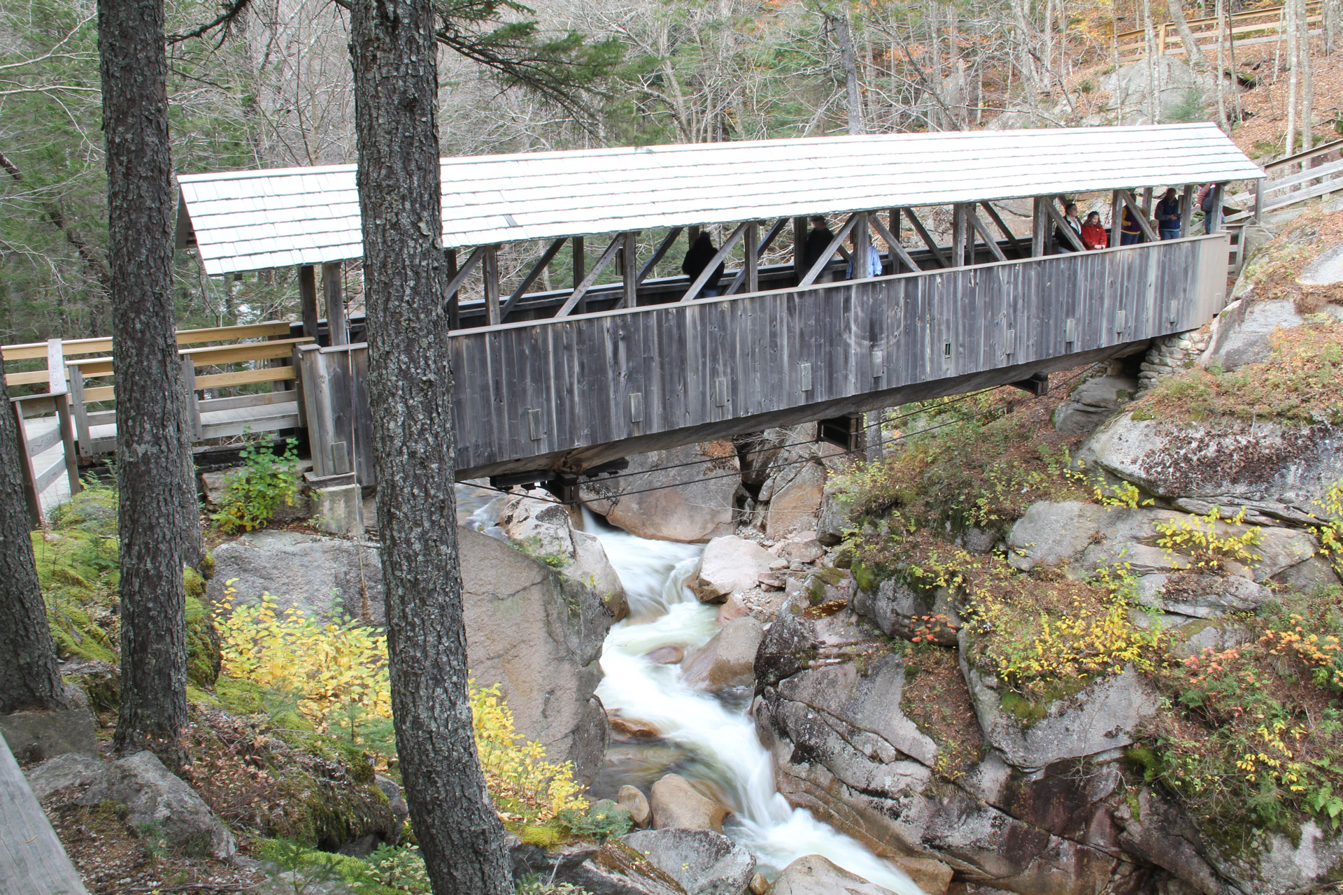
Sentinel Pine Bridge [30] Lincoln Pemigewasset River 193938In Franconia Notch State Park at Flume Gorge. Foot traffic only.
Slate Bridge Swanzey Ashuelot River 20014Destroyed by fire in 1993, rebuilt in 2001.
Smith Millennium Bridge [31] Plymouth Baker River 200144Third bridge built on the site. "The strongest covered bridge in the world." Car and foot traffic.
Squam River Bridge [32] Ashland Squam River 199065Car and foot traffic.
Stowell Road Bridge [33] Merrimack Baboosic Brook 199066Car traffic only.
Stark Bridge Stark Upper Ammonoosuc River 1857 or 186237Beautiful bridge decorated with pendant acorn finials and painted bright white. No name plate. In the center of town. Car and foot traffic.
Sulphite Railroad Bridge Franklin Winnipesaukee River 189662Only remaining deck-covered railroad bridge in the U.S. Also called the "Upside Down Bridge" because the railroad ran over the top, now discontinued. Damaged by arson in 1980. No access.
Swift River Bridge Conway Swift River 186947Foot traffic only.
Swiftwater Bridge Bath Wild Ammonoosuc River 184929Car traffic only.
Tannery Hill Bridge [34] Gilford Gunstock River 199568Plaque: "Constructed by the Gilford Rotary Club. Tim Andrews - Bridgebuilder." Foot traffic only.
Teixeira Park Bridge Peterborough Nubanusit Brook 1965In Teixeira Park.
Turkey Jim's Bridge [35] Campton West Branch Brook195842Restored in 1958, washed out in 1964, restored in 2013. Inside the Branch Brook Campground. Foot traffic only.
Waterloo Bridge Warner Warner River 184013Car traffic only.
Wentworth Golf Club [36] Jackson Ellis River 1991Part of the Wentworth Golf Club course. Golf cart and foot traffic only.
West Swanzey Bridge Swanzey Ashuelot River 18325Also called Thompson Bridge. Car and foot traffic.
Albany Bridge [37] Albany Swift River 185849Also called Albany Bridge. Built in 1857, destroyed by windstorm in 1858, rebuilt in 1858. Car and foot traffic.
Whittier Bridge Ossipee Bearcamp River 1870s46Closed since 2008, currently located on dry land off of Nudd Road, restoration timeline unclear as of September 2019. [38] Bridge reinstalled over the river in 2022.
Wright's Bridge Newport Sugar River 190658Foot traffic only.
Yankee Barn Bridge [39] Grantham Eastman Pond 1982Part of the Eastman Community Association, not accessible to general public. Foot traffic only.
Stoney Morrell BridgeConwayDitch199970On Kennett High School Campus.

Lost covered bridges

This is a partial list of other covered bridges that once stood in New Hampshire.

Notes

  1. Covered bridge number, as issued by the state; extant bridges are not numbered sequentially. [1]
  2. Columbia Bridge is listed on the state's website as No. 28, which appears to be a typo.

Related Research Articles

<span class="mw-page-title-main">New Hampshire</span> U.S. state

New Hampshire is a state in the New England region of the Northeastern United States. It borders Massachusetts to the south, Vermont to the west, Maine and the Gulf of Maine to the east, and the Canadian province of Quebec to the north. Of the 50 U.S. states, New Hampshire is the fifth smallest by area and the tenth least populous, with a population of 1,377,529 residents as of the 2020 census. Concord is the state capital and Manchester is the most populous city. New Hampshire's motto, "Live Free or Die", reflects its role in the American Revolutionary War; its nickname, "The Granite State", refers to its extensive granite formations and quarries. It is well known nationwide for holding the first primary in the U.S. presidential election cycle, and for its resulting influence on American electoral politics.

<span class="mw-page-title-main">Hillsborough County, New Hampshire</span> County in New Hampshire, United States

Hillsborough County is the most populous county in the U.S. state of New Hampshire. As of the 2020 census, the population was 422,937, almost one-third the population of the entire state. Its county seats are Manchester and Nashua, the state's two biggest cities. Hillsborough is northern New England's most populous county as well as its most densely populated.

<span class="mw-page-title-main">Bedford, New Hampshire</span> Town in New Hampshire, United States

Bedford is a town in Hillsborough County, New Hampshire, United States. At the 2020 census, the population was 23,322, reflecting a growth of 10% from 2010. Bedford is a suburb of Manchester, New Hampshire's largest city.

<span class="mw-page-title-main">Litchfield, New Hampshire</span> Town in New Hampshire, United States

Litchfield is a town in Hillsborough County, New Hampshire, United States. The population was 8,478 at the 2020 census.

<span class="mw-page-title-main">Manchester, New Hampshire</span> Largest city in New Hampshire, United States

Manchester is the most populous city in the U.S. state of New Hampshire and the tenth most populous in New England. As of the 2020 census, it had a population of 115,644.

<span class="mw-page-title-main">Nashua, New Hampshire</span> City in New Hampshire, United States

Nashua is a city in southern New Hampshire, United States. As of the 2020 census, it had a population of 91,322, the second-largest in northern New England after nearby Manchester. Along with Manchester, it is a seat of New Hampshire's most populous county, Hillsborough.

<span class="mw-page-title-main">Hooksett, New Hampshire</span> Town in New Hampshire, United States

Hooksett is a town in Merrimack County, New Hampshire, United States. The population was 14,871 at the 2020 census, up from 13,451 at the 2010 census. The town is located between Manchester, the state's largest city, and Concord, the state capital. A prominent landmark is Robie's Country Store, a National Historic Landmark and a frequent stop for presidential candidates during the New Hampshire primary.

<span class="mw-page-title-main">Hudson, New Hampshire</span> Town in New Hampshire, United States

Hudson is a town in Hillsborough County, New Hampshire, United States. It is located along the Massachusetts state line. The population was 25,394 at the 2020 census. It is the tenth-largest municipality in the state, by population.

<span class="mw-page-title-main">U.S. Route 3</span> Highway in the United States

U.S. Route 3 (US 3) is a United States Numbered Highway running 277.90 miles (447.24 km) from Cambridge, Massachusetts, through New Hampshire, to the Canada–United States border near Third Connecticut Lake, where it connects to Quebec Route 257.

<span class="mw-page-title-main">Interstate 293</span> Highway in New Hampshire

Interstate 293 (I-293) is an 11-mile-long (18 km) auxiliary Interstate Highway surrounding Manchester, New Hampshire, roughly shaped like two sides of a triangle. Completing the loop in the northeast is I-93. The southern portion of the loop shares the road with New Hampshire Route 101 (NH 101) and passes near Manchester–Boston Regional Airport and The Mall of New Hampshire. The western portion of the loop shares the road with the Everett Turnpike, but there are no tolls on this portion of the turnpike.

<span class="mw-page-title-main">Lowell Line</span> MBTA Commuter Rail line

The Lowell Line is a railroad line of the MBTA Commuter Rail system, running north from Boston to Lowell, Massachusetts. Originally built as the New Hampshire Main Line of the Boston & Lowell Railroad and later operated as part of the Boston & Maine Railroad's Southern Division, the line was one of the first railroads in North America and the first major one in Massachusetts.

The Frederick E. Everett Turnpike, also called the Central New Hampshire Turnpike, is a controlled-access toll road in the U.S. state of New Hampshire, running 44 miles (71 km) from the Massachusetts border at Nashua north to Concord. The Everett Turnpike is named for Frederick Elwin Everett, the first commissioner of the New Hampshire Department of Transportation.

<span class="mw-page-title-main">New Hampshire Route 101</span> East-west highway in southern New Hampshire, U.S.

New Hampshire Route 101 is a state-maintained highway in southern New Hampshire extending from Keene to Hampton Beach. It is the major east–west highway in the southern portion of the state. Most of its eastern portion is a major freeway linking the greater Manchester area to the Seacoast Region. At 95.189 miles (153.192 km) in length, NH 101 nearly spans the entire width of southern New Hampshire.

<span class="mw-page-title-main">Circumferential Highway (Nashua)</span>

The Circumferential Highway is the common name for a freeway bypass around the city of Nashua in southern New Hampshire, most of which has not yet been built. The purpose of the highway is to provide easier access to the F.E. Everett Turnpike and U.S. Route 3 in Nashua. Most of the highway is planned to be built in Hudson, with small sections also built through the towns of Litchfield and Merrimack as well as the city of Nashua.

<span class="mw-page-title-main">Merrimack Valley</span> Region in the U.S. states of New Hampshire and Massachusetts

The Merrimack Valley is a bi-state region along the Merrimack River in the U.S. states of New Hampshire and Massachusetts. The Merrimack is one of the larger waterways in New England and has helped to define the livelihood and culture of those living along it for millennia.

The New Hampshire Rail Transit Authority (NHRTA) was a short lived administrative agency attached to the New Hampshire Department of Transportation (NHDOT) which was created in 2007 to oversee the development of commuter rail and other passenger rail service in New Hampshire. The agency would prove to be extraneous; constant political opposition and funding issues would hamper all NHRTA rail projects. By 2019 the group had ceased to meet, and their website URL had lapsed. Since then, the NHDOT has overseen all rail projects within the state.

<span class="mw-page-title-main">The Church of Jesus Christ of Latter-day Saints in New Hampshire</span>

The Church of Jesus Christ of Latter-day Saints in New Hampshire refers to the Church of Jesus Christ of Latter-day Saints and its members in New Hampshire.

<span class="mw-page-title-main">Goffstown Covered Railroad Bridge</span> United States historic place

The Goffstown Covered Railroad Bridge was a rare railroad covered bridge in Goffstown, New Hampshire. It was built in 1901 by the Boston and Maine Railroad, on the site of an earlier bridge built in 1850 by the New Hampshire Central Railroad, and carried its tracks across the Piscataquog River in the center of Goffstown. The bridge was listed on the National Register of Historic Places in 1975. It was destroyed by arson in 1976, as would later be the case with the Hillsborough Railroad Bridge in 1985.

<span class="mw-page-title-main">2018 United States House of Representatives elections in New Hampshire</span>

The 2018 United States House of Representatives elections in New Hampshire were held on November 6, 2018, to elect the two U.S. representatives from the state of New Hampshire, one from each of the state's two congressional districts. The elections coincided with other elections to the House of Representatives, elections to the United States Senate and various state and local elections.

References

  1. 1 2 "Bridge Name List". New Hampshire Division of Historical Resources . Retrieved July 1, 2020 via NH.gov.
  2. Taormina, Barbara (August 4, 2011). "Volunteers team up to build NH's 55th covered bridge". New Hampshire Union Leader . Archived from the original on November 10, 2017. Retrieved September 28, 2020 via Wayback Machine.
  3. Photo at Bridgehunter web site.
  4. Photos at NH Tour Guide web site.
  5. Photo at Manchester Union Leader's New Hampshire web page.
  6. Photo at Manchester Union Leader's New Hampshire web page.
  7. Photo at Bridgehunter web page.
  8. Photo at NH Tour Guide web site.
  9. Photo at Bridgehunter.
  10. Photos at Dale Travis' "Round Barns & Covered Bridges" web page.
  11. Photo at New Hampshire Official Government page.
  12. Chandler, Kim Varney (2023). Covered bridges of New Hampshire. Portsmouth: Peter E. Randall Publisher. ISBN   978-1-942155-52-2.
  13. Photo at New Hampshire's Official Government page.
  14. Photo at James Walsh's Photography page.
  15. "How the Goffe's Mill Bridge was saved from destruction: Dubois & King, Stan Graton team up to move structure from Bedford to Wentworth". NH Business Review. April 17, 2015. Retrieved November 6, 2017.
  16. Photo at New Hampshire's Official Government web site.
  17. Photos at Dale Travis' "Round Barns & Covered Bridges" web page.
  18. Photo at HoodKroft Country Club web site.
  19. Photo on the Jack O Lantern History web page.
  20. Photo at NH Golfer web site.
  21. Photo and description at Official NH Covered Bridges page.
  22. Photo at "New Hampshire Covered Bridges List" web page.
  23. Photo of Mossy Glen at New England Waterfalls web page.
  24. Photo and article at Manchester Union Leader's New Hampshire web page.
  25. Photo and description at Official NH Covered Bridges page.
  26. Photo at "New Hampshire Covered Bridges List" web page.
  27. Photo at Upstate NH web site
  28. Photo at Royal Crest Estates Apartments web page.
  29. Photo at New Hampshire State Government web page.
  30. Photo at NH State Parks web page.
  31. Photo at the Manchester Union Leader's New Hampshire web page.
  32. Photo at NH.Life web page.
  33. Photo at Only in Your State web page.
  34. Photo at Bridgehunter web site.
  35. Photo at NH Tour Guide.
  36. Photo on Wentworth Golf Club web page.
  37. Photos at NH Tour Guide web site.
  38. Steer, Daymond (September 18, 2019). "NHDOT returns Whittier Covered Bridge funding". The Conway Daily Sun . Retrieved July 1, 2020.
  39. Photo at Doug Hill Photo
  40. 1 2 "Androscoggin River Bridge". Berlin, New Hampshire History. November 8, 2018. Archived from the original on 2022-02-26. Retrieved July 1, 2020 via Facebook. The old covered bridge crossing the Androscoggin River at Errol, 1939. It was built in 1860, and went out of service in 1941. This was one of two covered bridges in Errol, the other crossing Clear Stream. Both were replaced with steel bridges during a period of modernization.
  41. "Monument now marks site of covered bridge". Nashua Telegraph . September 9, 2013. Retrieved July 1, 2020.
  42. "Merrimack Covered Bridge Is Burned". Nashua Telegraph . June 7, 1967. p. 1. Retrieved July 1, 2020 via newspapers.com.
  43. "Old Runnells Bridge Coming Down; No Effort to Save It". Nashua Telegraph . January 9, 1950. p. 1. Retrieved July 1, 2020 via newspapers.com.
  44. "Turkey Hill Covered Bridge Site". merrimacknh.gov. Town of Merrimack. Retrieved July 1, 2020.

Further reading