The New River Gorge Bridge is a steel arch bridge 3,030 feet (924 m) long over the New River Gorge near Fayetteville, West Virginia, in the Appalachian Mountains of the eastern United States. With an arch 1,700 feet (518 m) long, the New River Gorge Bridge was the world's longest single-span arch bridge for 26 years; it is now the fifth longest; the longest outside of China. Part of U.S. Route 19, its construction marked the completion of Corridor L of the Appalachian Development Highway System. An average of 16,200 motor vehicles cross the bridge each day.

The George P. Coleman Memorial Bridge is a double swing bridge that spans the York River between Yorktown and Gloucester Point, in the United States state of Virginia. It connects the Peninsula and Middle Peninsula regions of Tidewater, Virginia. The bridge is the only public crossing of the York River, though State Route 33 crosses both of its tributaries just upriver of their confluence at West Point.

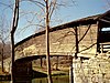
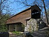
The Humpback Covered Bridge located in the U.S. state of Virginia, is one of the few remaining covered bridges in the United States that was built higher in the middle than on either end; hence the name of "humpback". The bridge was built in 1857 and is also the oldest remaining covered bridge in the state of Virginia. Its WGCB number is 46-03-01. The bridge spans a tributary of the Jackson River known as Dunlap Creek, for a distance of 109 feet (33 m). The humpback feature is 4 feet (1.2 m) higher in the center than at either end. The bridge is located near the city of Covington, Virginia.

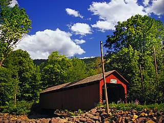
Woolwine is an unincorporated community in northern Patrick County, Virginia, United States. The western terminus of State Route 40 is here, at State Route 8. The community lies in the Rocky Knob American Viticultural Area. Two covered bridges are located in Woolwine: the Jack's Creek Covered Bridge and the more recent Clifford Wood Covered Bridge which is privately owned. They span the Smith River. The Bob White Covered Bridge, which also spanned the Smith River, was destroyed during flooding on September 29, 2015.

The Swann Covered Bridge, also called the Joy Covered Bridge or Swann-Joy Covered Bridge, is a county-owned, wood-and-metal combination style covered bridge that spans the Locust Fork of the Black Warrior River in Blount County, Alabama, United States. It is located on Swann Bridge Road off State Route 79, just west of the town of Cleveland, about 10 miles (16 km) northwest of Oneonta.
The Coldwater Covered Bridge, also known as the Hughes Mill Covered Bridge, is a locally owned wooden covered bridge that spans the outflow from Oxford Lake in Calhoun County, Alabama, United States. It is located at Oxford Lake Park off State Route 21 in the city of Oxford, about 4 miles south of Anniston.

The Horton Mill Covered Bridge is a state-owned wooden covered bridge that spans the Calvert Prong of the Little Warrior River in Blount County, Alabama, United States. It is located on a river crossing to Ebell Road and Covered Bridge Circle, off State Route 75 about 5 miles (8.0 km) north of the city of Oneonta.
The Easley Covered Bridge, also known as the Old Easley Covered Bridge or Rosa Covered Bridge, is a county-owned wood and metal combination style covered bridge that spans Dub Branch of the Calvert Prong of the Little Warrior River in Blount County, Alabama, United States. It is located on Easley Bridge Road off U.S. Route 231, just south of the town of Rosa, about 5 miles northwest of Oneonta. Coordinates are 33°58′16″N86°31′07″W.
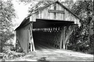
The Nectar Covered Bridge was a wood and metal combination style covered bridge which spanned the Locust Fork of the Black Warrior River in Blount County, Alabama, United States. It was located on Nectar Bridge Road off State Route 160, just east of the town of Nectar, about 14 miles northwest of Oneonta. Nectar Covered Bridge was at one time the seventh-longest covered bridge in the country. The bridge remained open to single lane motor traffic from its construction until it was burned by vandals on June 13, 1993.
The Oakachoy Covered Bridge, also known as the Thomas Covered Bridge, was a county-owned wooden covered bridge which spanned Oakachoy Creek in Coosa County, Alabama, United States. It was located in a remote area on the dirt portion of Newman Road off State Route 259 northeast of the community of Nixburg, about 6 miles southwest of Alexander City.

The Bob White Covered Bridge, also known as the Lower Covered Bridge or Woolwine Covered Bridge, was a county-owned wooden covered bridge that spanned the Smith River in Patrick County, Virginia, United States. It was located on the old portion of Bob White Road off State Route 8 southeast of the community of Woolwine, about 13 miles north of Stuart. Coordinates were 36°46′44.82″N80°14′51.26″W.

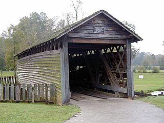
The Jack's Creek Covered Bridge, also known as the Upper Covered Bridge, is a county-owned wooden covered bridge that spans the Smith River in Patrick County, Virginia, United States. It is located on Jack's Creek Road (SR 615) off State Route 8 just south of the community of Woolwine, about 11 miles (18 km) north of Stuart.
The Sonestown Covered Bridge is a covered bridge over Muncy Creek in Davidson Township, Sullivan County, Pennsylvania built around 1850. It is 110 ft (34 m) long and was placed on the National Register of Historic Places (NRHP) in 1980. It is named for the nearby unincorporated village of Sonestown in Davidson Township, and is also known as the Davidson Covered Bridge. It was built to provide access to a grist mill which operated until the early 20th century.

The Medora Covered Bridge was the longest covered bridge in the United states with the entire original historic truss still in place with some repairs but no structural changes. Measuring the clear span of 431 feet 10 inches (131.62 m), the Medora Covered Bridge is the longest historic covered bridge in the United States. The roof length of 461 feet (141 m) and the siding at the floor length of 459 feet (140 m) are also the longest historic covered bridge measurements in the U.S.

The Catoctin Creek Bridge crosses over Catoctin Creek in Loudoun County, Virginia.
The Lidy Walker Covered Bridge, formerly known as the Big Branch Covered Bridge, was a privately owned wood-&-metal combination style covered bridge which spanned the outlet to Lidy's Lake in Cullman County, Alabama, United States. It was located in the Berlin community at a pasture near the lake off Cullman County Road 1616 near U.S. Route 278, 6 miles east of the city of Cullman.

Valley Railroad Stone Bridge is a historic stone arch bridge spanning Folly Mills Creek near Jolivue, Augusta County, Virginia. It was built in 1874 by the Valley Railroad, and is a four-span structure with an overall length of 130 feet (40 m) and a width of 15 feet (4.6 m). It is constructed of granite and faced in ashlar and features semi-circular arches set on gently splayed piers. It was acquired by the Virginia Department of Transportation in 1965. It is considered a scenic landmark along Interstate 81.