Kodigehalli

Last updated

Kodigehalli
Neighbourhood
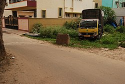
Kodigehalli wide angle.jpg
Kodigehalli wide angle
Country India
State or Union Territory Karnataka
City Bangalore

Kodigehalli is a suburb of Bangalore(B.B.M.P. Ward 8). Historic temples and modern constructions are cheek by jowl. Kodigehalli is to the south of Sahakarnagar . The new airport road to Kodigehalli main road via Kodigehalli circle connects the Kodigehalli area.

Contents

To the west of the Kodigehalli railway station is a road that leads to Thindlu. The Kodigehalli bus stop is marked by the Dodda Ganapa Devasthana (a Ganapathi temple). There are frequent buses to the city centre. To the east of Kodigehalli is a new residential layout called Tatanagar, which is also called the I.I.Sc layout. This is because the layout was made by current and former employees of I.I.Sc. In this place Aadhar headquarter is located. To the east of Tatanagar is the area Bhadrappa Layout, on the outer ring road. On the road from Kodigehalli to Tatanagar, there is an Omkareswara temple and a Ganga temple.

History

Bengaluru was first mentioned in records from the Ganga era as a small hamlet, the location of which coincides with modern Halebengaluru near Kodigehalli (not far from Hebbal). It is said that when Kempe Gowda built his new capital town in about 1537, he called it Bengaluru as his mother and wife belonged to the hamlet of Halé Bengaluru (Old Bangalore). [1] Stone Age weapons from 2000 to 1000 B.C. have been found near Jalahalli, Siddapur, and Gavipura. [2] Jalahalli is very near the Kodigehalli area. The Directorate of Census Operations completed its decadal Census recently.[ when? ] During the Census, the department discovered that Bangalore had human habitation as early as 4,000 B.C (Middle Stone Age), and stone implements were found at Jalahalli, Sudasandra, Siddhapura, and Jadigenahalli belonging to this period. Around 1,000 B.C (Iron Age), burial grounds were established at Koramangala and Chikkajala on the outskirts of Bangalore. In 27 B.C., coins of the Roman emperors Augustus, Tyberious, and Cladius were found at Yeshwantpur and HAL, which indicated the signs of civilisation and Bangalore's trans-oceanic contacts. [3] Kodigehalli is so called because it was a gift from the king, Veera Ballala to a resident of that area, an old lady who fed him.

See also

Related Research Articles

<span class="mw-page-title-main">Kempe Gowda I</span> Founder of Bangalore (1510–1569)

Kempe Gowda I, locally venerated as Nadaprabhu Kempe Gowda, or commonly known as Kempe Gowda, was a governer under the Vijayanagara Empire in early-modern India. He is famous for the development of Bangalore Town in the 16th century. Kempegowda erected many Kannada inscriptions across the region. He also authored Ganga-gauri-vilasa, a yakshagana (verse-play) in Telugu. He is commemorated with various statues and memorials and many places are named after him in Bangalore.

<span class="mw-page-title-main">Basaveshwaranagara</span> Neighborhood in Bengaluru Urban, Karnataka, India

Basaveshwaranagara, also known as Basaveshwaranagar, Basaveshnagara or Basaveshnagar is a largely residential neighbourhood in the west of Bengaluru, Karnataka, India. It is located to the west of Rajajinagara and is sandwiched between the localities of Mahalakshmi Layout to the north and Vijayanagara to the south, spread across multiple sub-localities, three assembly constituencies and seven Bruhat Bengaluru Mahanagara Palike (BBMP) wards. The area of Basaveshwaranagara is often considered West of Chord Road as it lies to the west of Chord Road, an arterial road in the western part of Bengaluru.

<span class="mw-page-title-main">Hebbal, Bangalore</span> Neighbourhood in Bengaluru, Karnataka, India

Hebbal, is a neighbourhood in Bengaluru, Karnataka, India, which was once indicative of the north endpoint of the city. Though originally famous for Hebbal Lake, it is now better known for the serpentine maze of flyovers that network the Outer Ring Road and Airport Road on NH 44. The flyover spans a length of 5.23 kilometres (3.2 mi) over all the loops combined. The flyover was built by Gammon India. The lake area in Hebbala is well-known for its picnic spots, a well-maintained park, boating facilities and for the bird watching opportunities.

<span class="mw-page-title-main">History of Bangalore</span> Account of past events in Bengaluru, India

Bangalore is the capital city of the state of Karnataka. Bangalore, as a city, was founded by Kempe Gowda I, who built a mud fort at the site in 1537. But the earliest evidence for the existence of a place called Bangalore dates back to c. 890.

Begur is a town in the Indian state of Karnataka. It is located off Bengaluru-Hosur highway. It is said to have been a prominent place during the rule of the Western Ganga Dynasty and later the Chola Kingdom.

<span class="mw-page-title-main">Kengeri</span> Suburb in Bengaluru Urban, Karnataka, India

Kengeri is a western suburb of Bangalore city,located along Mysore Road.It is bordered by Nagarbhavi and Ullal to the north, Rajarajeshwari Nagar to the east,Kumbalgodu to the west and Uttarahalli to the south.

Kunigal is a town in Tumakuru district in the Indian state of Karnataka. It is the headquarters of Kunigal taluk. As of 2011 census, the town has a population of 34155.

<span class="mw-page-title-main">Thirumakudalu Narasipura</span> Town in Karnataka, India

Tirumakudalu Narasipura the temple city of Karnataka, commonly known as T. Narasipura or T.N. Pura, is a town in Mysore district in the Indian state of Karnataka. The first name refers to the land at the confluence, (trimakuta in Sanskrit at the confluence of the Kaveri, Kabini and Spatika Sarovara.

Vidyaranyapura is situated in the northern part of Bangalore city in the state of Karnataka, India. Vidyaranyapura, along with several other extensions of the city, comes under a constituency called Byatarayanapura. It comes under the Greater Bangalore jurisdiction of the Bruhat Bengaluru Mahanagara Palike (BBMP).

<span class="mw-page-title-main">Jalahalli</span> Suburb in Jalahalli metro, Karnataka, India

Jalahalli is a suburb in northern part of Bengaluru is one of the greenest areas of Bengaluru. It is mainly divided into Jalahalli East and Jalahalli West. Gangamma Circle is the junction between the roads connecting Jalahalli East, Jalahalli West, Jalahalli Village, and Jalahalli Cross. The National Academy of Customs and Narcotics in Bengaluru is located here.

Located in South Bangalore, Karnataka, India, Kumaraswamy Layout is a sub locality in Banashankari.

Sahakara Nagar is a residential suburb near Bangalore, India. Sahakanagar is formed by the Ministry of Communication Employees housing society and has developed to this extent under the efforts of the Sahakaranagar Residents welfare association. Ever since the inclusion of 45 new wards to Bangalore city in 2008, Sahakara Nagar comes under the BBMP limits. The locality is accessible via NH 7 on the East. Sahakara Nagar was formed in the early 1980s as a co-operative society for Telecom and Post & Telegraph employees of the Government of India. It has over 8 well maintained parks and two Playgrounds maintained by BBMP. Owing to its proximity to Hebbal lake, Amrutahalli lake and GKVK forest land, it is often called the Prague of Bengaluru city.

<span class="mw-page-title-main">Bellandur</span> Suburb in Bangalore Urban, Karnataka, India

Bellandur is a suburb in south-east Bangalore, Karnataka, India. It is bounded by HSR Layout to the west, Devarabisanahalli to the east, Sarjapur Road to the south, and the Bellandur Lake to the north. The Bellandur Lake is the largest lake in Bangalore, and separates Bellandur from the HAL Airport. The Outer Ring Road passes through Bellandur, making the area an important transit point between east and south Bangalore.

<span class="mw-page-title-main">Kannada inscriptions</span>

About 25,000 inscriptions found in Karnataka and nearby states belong to historic Kannada rulers, including the Kadambas, the Western Ganga Dynasty, the Rashtrakuta, the Chalukya, the Hoysala and the Vijayanagara Empire. Many inscriptions related to Jainism have been unearthed. The inscriptions found are generally on stone (Shilashasana) or copper plates (Tamarashasana). These Kannada inscriptions are found on historical hero stones, coins, temple walls, pillars, tablets and rock edicts. They have contributed towards Kannada literature and helped to classify the eras of Proto Kannada, Pre Old Kannada, Old Kannada, Middle Kannada and New Kannada. Inscriptionsdepict the culture, tradition and prosperity of their era. The literatureof Ramayana and Mahabharata are transferred through the generations by these inscriptions. Hazara Rama Temple and Aranmula Parthasarathy Temple are the best examples of temples associated with Kannada inscriptions.

<span class="mw-page-title-main">Ramamurthy Nagar</span> Neighbourhood in Bangalore Urban, Karnataka, India

Ramamurthy Nagar ( ) is an area in Bangalore in the Indian state of Karnataka. It is located in the north-eastern part of Bangalore and comes under the E3 subdivision of BBMP. It is a rapidly growing suburb, adjacent to other areas such as Banaswadi, CV Raman Nagar and Krishnarajapuram, also officially called Krishnarajapura.

<span class="mw-page-title-main">Bangalore</span> Capital of Karnataka, India

Bangalore, officially Bengaluru, is the capital and largest city of the southern Indian state of Karnataka. It has a population of more than 8 million and a metropolitan population of around 15 million, making it India's third most populous city and fourth most populous urban agglomeration. It is the most populous city and largest urban agglomeration in South India, and is the 27th largest city in the world. Located on the Deccan Plateau, at a height of over 900 m (3,000 ft) above sea level, Bangalore has a pleasant climate throughout the year, with its parks and green spaces earning it the reputation of India's "Garden City". Its elevation is the highest of India's major cities.

Dollars Colony is an upmarket residential locality in Bangalore, India. It is situated towards the north of Bangalore Central Business District. It is located 874 meters above mean sea level.

<span class="mw-page-title-main">Hebbal-Kittayya inscription</span>

The Hebbal-Kittayya 750CE Inscription is one of the oldest known inscriptions in Kannada script and is Bangalore's oldest inscription. The inscription was re-discovered on 1 May 2018 in Hebbal. The inscription is on a Ooralivu Veeragallu in honour of Hebbal native Kittayya. Ooralivu veeragallu’s are memorial stones erected in honour of a person martyred defending an attack on his or her town.

<span class="mw-page-title-main">Allalasandra (Bengaluru) Inscriptions and Herostones</span> Temple inscriptions in Karnataka, India

Allalasandra is a historic locality in North Bengaluru adjoining the Gandhi Krishi Vigyan Kendra (GKVK) campus on Bellary road. Allalasandra is a part BBMP Ward Number 4, Byatarayanapura assembly (AC150) and Chikkaballapur parliamentary (PC27) constituencies with about 20,000 voters.

References

13°03′22″N77°34′24″E / 13.0560°N 77.5733°E / 13.0560; 77.5733