Related Research Articles

The Mumbai Metro is a rapid transit (MRT) system serving the city of Mumbai and the wider Mumbai Metropolitan Region in Maharashtra, India.

Basaveshwaranagara, also known as Basaveshwaranagar, Basaveshnagara or Basaveshnagar is a largely residential neighbourhood in the west of Bengaluru, Karnataka, India. It is located to the west of Rajajinagara and is sandwiched between the localities of Mahalakshmi Layout to the north and Vijayanagara to the south, spread across multiple sub-localities, three assembly constituencies and seven Bruhat Bengaluru Mahanagara Palike (BBMP) wards. The area of Basaveshwaranagara is often considered West of Chord Road as it lies to the west of Chord Road, an arterial road in the western part of Bengaluru.
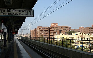
Mayur Vihar is an upmarket residential area in East Delhi close to the Noida-Delhi border, situated just across the Yamuna River, and is divided into three distinct phases. As the name suggests, it has been the dwelling (vihar) of peacocks (mayur). Even today, the area has a closed sanctuary dedicated to the conservation of peacocks.
The Outer Ring Road (ORR), officially renamed as Dr. Puneeth Rajkumar Vartula Raste, is a ring road that runs around most of the perimeter of the city of Bangalore, Karnataka, India. This 60-kilometre-long (37 mi) road was developed by the Bangalore Development Authority and different sections were opened progressively between 1996 and 2002. IT firms on the Outer Ring Road generate revenue of US$ 22 billion every year, accounting for 32% of Bengaluru’s total IT revenue.
The Bangalore Development Authority (BDA) of Bangalore, India, is a governmental organization and the principal planning authority for Bangalore. Its function, under the Karnataka Town and Country Planning Act of 1961, is as a regulatory body required "to prepare in the prescribed manner a Comprehensive Development Plan" for the Bangalore Metropolitan Region. It also oversees planning and development of infrastructure, provision of development-related sites and services, the housing needs of underprivileged citizens in Bangalore and is currently the city's largest land developer. No other authority or person may undertake development within the Bangalore Metropolitan Region without the permission of the BDA.
Vijayanagara, is a residential neighborhood in west Bangalore, India. It derives its name from the Vijayanagara empire that flourished in South India during the 15th and 16th centuries. It is bound by Mysore Road and Magadi Road, with Chord Road cutting through. It is the northernmost area in South Bangalore.
Located in South Bangalore, Karnataka, India, Kumaraswamy Layout is a sub locality in Banashankari.
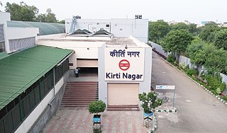
The Kirti Nagar metro station is an interchange station between the Blue Line and Green Line of Delhi Metro. It is one of the eastward terminal stations of the Green Line, the other being Inderlok, and was opened as a part of a small 3.41 km (2.12 mi) branch from this station to Ashok Park Main station on 27 August 2011. This allowed passengers to easily transfer between the Red Line and Blue Line of the network.
Banaswadi is a locality situated in the eastern part of Bangalore, about 6 km from the city centre on the outskirts of Bangalore Cantonment, adjoining Thanisandra, Lingarajapuram, Kalyan Nagar, Kammanahalli,Cooke Town,Cox Town,Krishnarajapuram and Baiyyappanahalli. It is Ward no 27 of the BBMP and is further divided into two regions; Chikka Banaswadi and Dodda Banaswadi. Historically the area was known as primarily residential; little more than a village on the city outskirts; however the ongoing expansion of the city limits, the proximity of the locality to the international airport and the arrival of the outer ring road connecting Banaswadi to the City's IT hubs has seen the rapid improvement of the area and the emergence of a number of commercial and business activities.

Ramamurthy Nagar ( ) is an area in Bangalore in the Indian state of Karnataka. It is located in the north-eastern part of Bangalore and comes under the E3 subdivision of BBMP. It is a rapidly growing suburb, adjacent to other areas such as Banaswadi, CV Raman Nagar and Krishnarajapuram, also officially called Krishnarajapura.

Bengaluru Cantonment railway station, also known as Bangalore Cantonment railway station is one of the three important railway stations serving the city of Bangalore and it is located in the locality of Vasanth Nagar and adjoins Fraser Town,Benson Town and Shivajinagar. The Station started operations in 1864, with the launch of the Bangalore Cantonment – Jolarpettai train services by the Madras Railway. The train line was broad-gauge and 149 km long, connecting the Bangalore Cantonment with Vellore district. A total of 119 passenger trains start/end/pass through Bangalore Cantonment railway station. Total 499 stations are directly connected to Bangalore Cantonment railway station via these 269 passenger trains.
CMR University is a private university located in Bangalore, Karnataka, India. CMR University (CMRU) has been established and is governed by the CMR University Act of 2013. CMRU aims to promote and undertake the advancement of university education in law, technical, health, management, life sciences and other allied sectors of higher and professional education. CMR University is also recognized by AIU.

Bengaluru East railway station, also known as Bangalore East railway station, is an old British-era railway station surrounded by Pottery Road, Kumaraswamy Naidu Road, Murgesha Mudaliar Road and Kenchappa Road. It is a small quaint station located in Fraser Town, Bangalore Cantonment. This station is very convenient for residents traveling towards or returning from Kolar Gold Fields or Madras. Express and Mail trains did not stop here until the 1920s. The station is now renovated with a larger platform. Adjacent to the railway station is the Bangalore East Football Grounds, which nowadays is more used for playing cricket. Well-known cartoonist Paul Fernandes remembers as a young boy befriending train drivers at this station and getting grease for his bicycle.
The Pink Line of Namma Metro is under construction and will form part of the metro rail network for the city of Bangalore, Karnataka, India. The 21.25 km (13.20 mi) line connects Kalena Agrahara station on Bannerghatta Road in the south with Nagawara station on Outer Ring Road in the north. The Pink Line is mostly underground but also has a 6.98 km (4.34 mi) elevated section and a 0.48 km (0.30 mi) at-grade (surface) section. There are 18 stations on the line, including 12 underground and 6 elevated ones. Pink Line will have an interchange with the Purple Line at MG Road station. It will also have interchanges with the Yellow line at Jayadeva Hospital station and with the Blue Line at Nagawara. Both these lines are under construction. The entire line is planned to open at the end of March 2025.
Baiyyappanahalli or New Baiyyappanahalli Extension is one of the neighbourhoods in Bengaluru. It is part of C. V. Raman Nagar in East Bengaluru. The area is a transport hub and popular for Baiyappanahalli metro station and Baiyyappanahalli railway station.
Cantonment Railway Station is an upcoming important underground metro station on the North-South corridor of the Pink Line of Namma Metro in Bangalore, India. This metro station will comprise of the main Bengaluru Cantonment railway station for passengers heading towards the city, Kengeri, Krishnarajapuram, Hosur or Bangarapet Junction. It will also comprise of many prime locations like the main Coles Park, Karnataka Badminton Association, St. Mary's Basilica and residential suburban areas like Fraser Town, Shivajinagar and Richards Town. This metro station is stated to become operational around March 2025.
Pottery Town is an upcoming underground metro station on the North-South corridor of the Pink Line of Namma Metro in Bangalore, India. This metro station will comprise of the main Bangalore East and Banaswadi railway stations along with many prime locations like St. Anthony's Chapel, BBMP Regional Office and surrounding suburban areas like Williams Town, Fraser Town, Cox Town and Richards Town. This metro station is stated to become operational around March 2025.
Horamavu is an upcoming elevated metro station on the North-South corridor of the Blue Line of Namma Metro in Bangalore, India. Around this metro stations holds the main Horamavu suburban area which is adjacent to Banaswadi, Kalkere and Ramamurthy Nagar, followed by some prime furniture locations like Royaloak Furnitures, Cauvery Furnitures, Damro Furnitures and the famous Horamavu Bridge leading towards Kalkere and Dodda Banaswadi areas. This metro station is slated to become operational around June 2026.

Kalyan Nagar is an upcoming elevated metro station on the North-South corridor of the Blue Line of Namma Metro in Bangalore, India. Around this metro station holds the main Kalyan Nagar BMTC Bus Depot cum Bus Stop followed by many prime Jewellery retail stores like Lalitha Jewellery, Tanishq, Kalyan Jewellers, Jos Alukkas and neighbouring Kammanahalli, Hennur and Chelekkere suburban areas. This metro station is slated to become operational around June 2026.
HBR Layout is an upcoming elevated metro station on the north–south corridor of the Blue Line of Namma Metro in Bangalore, India. Around this metro station comprises the main Hennur Bio-Diversity Park followed by prime locations like VBR PU College, Sun Technology Integrators Pvt. Ltd., Bhima Jewellers, a couple of car company showrooms like Nissan, Mahindra, Hyundai and prime neighbouring areas like Hennur, Lingarajapuram and Outer Ring Road leading towards Hebbal in the north and Kalyan Nagar, Krishnarajapuram and Silk Board in the south. This metro station is stated to become operational around June 2026.
References
- ↑ Muyiwa, Joshua (23 March 2019). "Bengaluru's Kamanahattan". mint. Retrieved 7 August 2021.
- ↑ Menezes, Tapan (17 May 2017). "Keeping pace with change". Deccan Herald. Retrieved 6 July 2017.
- ↑ Dhamija, Anshul (10 March 2013). "Kammanahalli booms into travel hub". The Times of India. Retrieved 6 July 2017.