Varthur

Last updated

Varthur
Neighbourhood
Sunset vtr lake.jpg
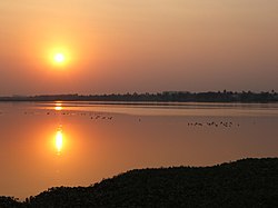
Sunset over Varthur lake.
India Karnataka location map.svg
Red pog.svg
Varthur
Coordinates: 12°56′27″N77°44′48″E / 12.940699°N 77.746596°E / 12.940699; 77.746596
CountryIndia
State Karnataka
District Bangalore
MetroBangalore
Government
  Body BBMP
Population
 (January 2015)
  Total46,000
Languages
  Official Kannada
Time zone UTC+5:30 (IST)
PIN
560 087
Telephone code91-(0)80-2853XXXX
Vehicle registration KA 53
Lok Sabha constituencyBangalore Central
Vidhan Sabha constituencyMahadevapura

Varthur is a suburb situated in the Eastern periphery of Bangalore City and part of the internationally famous Whitefield township. Varthur is a Hobli and part of the Bruhat Bangalore Mahanagara Palike. Varthur was a Legislative Assembly in the state of Karnataka but was split into three legislative assemblies C.V.Raman Nagar, Mahadevapura and Krishnarajapura in the year 2008. It is also one of the wards of BBMP. It is located in South-Eastern Bangalore between old Airport road and Sarjapur road. Varthur is very close to ITPB.

Contents

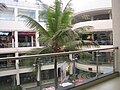
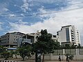
There are many IT companies in Varthur Hobli. The head office of one of the largest IT companies, Wipro Technologies is situated here. Some other companies such as Cisco Systems, ARM, and Aricent Group, are situated in Varthur Hobli.

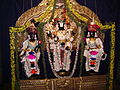
At Varthur, people celebrate Brahmarathotsava of Sri Chennaraya Swamy, which happens on the day of Ratha Saptami. It is one of the famous events that takes place in this area. Two days later is Karaga of Sri Draupathamma (Draupadi) at Sri Dharmaraya Swamy (Yudhishthira) temple, which happens at night and is visited by thousands of people from Varthur, Gunjur, Madhuranagara, Whitefield, Ramagondannahalli, Balagere, Sorahunase, Immadihalli, Harohalli, Muthsandra, and Kotur.

Geography

Varthur is located at 12°56′27″N77°44′48″E / 12.940699°N 77.746596°E / 12.940699; 77.746596 . The Ponnaiyar flows through Varthur.

Administration

Educational institutions

Varthur Main Road

The stretch starting from HAL old Airport road till Varthur via Marathahalli, Kundalahalli, Thubarahalli, Siddhapura, Ramagondanahalli, and Varthur Kodi is officially known as Varthur Main Road.

Varthur road, Bangalore (13945201583).jpg

Varthur lake

The lake ecosystem is an integral part of Bangalore, although unplanned urbanisation and industrialisation have led to the contamination of these water bodies. Varthur Lake, which has an area of 180.40 ha (445.8 acres) is the second largest lake [1] in Bangalore city and also one of the most polluted [2] lakes in Bangalore. Its ecosystem is under continuous degradation because of sewage water from Bangalore entering the lake from Bellandur Lake, further upstream.

This is a man-made lake, built by the Ganga kings thousands of years ago [1] for agriculture and domestic uses but now the lake is receiving 40% of the sewage water from Bangalore for over 50 years resulting in eutrophication.

Related Research Articles

<span class="mw-page-title-main">Whitefield, Bangalore</span> Neighbourhood in Bangalore, Karnataka, India

Whitefield is a neighbourhood of Bangalore in the state of Karnataka, India. Established in 1882 as a settlement for the Eurasians and Anglo Indians of Bangalore, Whitefield remained a quaint little settlement at the eastern periphery of Bangalore city till the late 1990s when the local IT boom turned it into a major suburb. It is now a major part of Greater Bangalore. Whitefield is Bengaluru's first tech corridor to be connected by Namma Metro.

<span class="mw-page-title-main">Domlur</span> Neighbourhood in Bangalore, Karnataka, India

Domlur is a small township located in the eastern part of Bangalore city in India. Domlur was included in the erstwhile Bangalore Civil and Military Station under the British Madras Presidency till it was transferred to the Mysore State in 1949.

<span class="mw-page-title-main">Basaveshwaranagara</span> Neighborhood in Bengaluru Urban, Karnataka, India

Basaveshwaranagara, also known as Basaveshwaranagar, Basaveshnagara or Basaveshnagar is a largely residential neighbourhood in the west of Bengaluru, Karnataka, India. It is located to the west of Rajajinagara and is sandwiched between the localities of Mahalakshmi Layout to the north and Vijayanagara to the south, spread across multiple sub-localities, three assembly constituencies and seven Bruhat Bengaluru Mahanagara Palike (BBMP) wards. The area of Basaveshwaranagara is often considered West of Chord Road as it lies to the west of Chord Road, an arterial road in the western part of Bengaluru.

<span class="mw-page-title-main">HSR Layout</span> Neighbourhood in Bangalore, Karnataka, India

HSR Layout, an abbreviation of Hosur Sarjapura Road Layout is a prominent suburb of South-Eastern Bangalore, India. The locality, initially developed by the Bangalore Development Authority in 1985 has now emerged into a coveted residential area due to its proximity to Electronic City, Sarjapur Road and the Outer Ring road on which I.T. Parks and other Special Economic Zones are located. It lies in the Bommanahalli constituency of the Karnataka State Assembly.

<span class="mw-page-title-main">Yelahanka</span> Suburb / satellite town in Bengaluru Urban, Karnataka, India

Yalahanka is a suburb and Taluk of Bangalore Urban district in the Indian state of Karnataka. One of the zones of BBMP. It is the oldest part of present Municipal Bengaluru (Bangalore) city and the northern end of the city. It is Nadaprabhu Kempegowda I, of the Yelahanka Prabhu clans, who laid the foundation of present-day Bengaluru through the creation of a "mud fort town" in 1537 CE

<span class="mw-page-title-main">Mahadevapura, Bangalore</span> Neighbourhood in Bengaluru Urban, Karnataka, India

Mahadevapura is a suburb and one of the zones of BBMP in Bangalore Urban district in the Indian state of Karnataka. It was a city municipal council. It is well connected with Outer Ring Road, Whitefield Road and Krishnarajapuram Railway Station is the nearest station to board trains. It is a developing area, which has a high growth potential in terms of residential development. Leading schools, shopping malls, showrooms have come up in the area.JBR Legal.

<span class="mw-page-title-main">Old Airport Road, Bangalore</span> Road in Bangalore, India

Old Airport Road is a major road in Bangalore, India. It was renamed from Airport Road after the new Bengaluru International Airport was opened at Devanahalli. Madivala Machideva Road is a 17 km stretch road which begins from the junction of Trinity Church Road and Victoria Road and goes to HAL Bangalore International Airport, Marathahalli, Varthur. Beyond that, the road officially becomes Varthur Road, but since the real estate boom started around 2003, builders have started calling the stretch between the Airport and the Marathahalli Outer Ring Road as Old Airport Road. Even so, due to the high significance of this road it has achieved due to its high accessibility for reaching Whitefield.

<span class="mw-page-title-main">Madiwala Lake</span> Lake in Bengaluru

Madiwala lake is one of the biggest lakes in Bangalore, India spread over an area of 114.3 hectare. The water in the lake was fit for drinking till the early 1990s. Since then it has become unfit for drinking due to industrial waste and sewage entering the waterbody. It has gradually become polluted.

Located in South Bangalore, Karnataka, India, Kumaraswamy Layout is a sub locality in Banashankari.

Mullur is a village near Sarjapur road in Karnataka, India. It is in Bengaluru East Taluk, Bengaluru District in Karnataka. An adjacent village is Gunjur via Kachamaranahalli. The distance from Vidhana Soudha is 22 km.out of the village there is one school called Sri Sri Ravishankar vidhya mandir and there is a railway station 3.5 km from the village.

Immadihalli is a suburb situated in the Eastern periphery of Bangalore City and part of Whitefield township. Immadihalli was a part of the Varthur Legislative Assembly, but now belongs to the Bruhat Bengaluru Mahanagara Palike BBMP[1]. Immadihalli belongs to Mahadevapura Legislative Assembly in the state of Karnataka with effect from the year 2008. Immadihalli is very close to ITPL, which is heart of IT in Bangalore. Immadihalli belongs to a green belt area so there are no industries located in and around. Immadihalli was one of the largest milk producing villages in Bangalore.

Carmelaram is a suburb of Bangalore situated at Varthur Hobli, Sarjapur road. Carmelaram was a village but is now a part of Bruhat Bengaluru Mahanagara Palike.

Bellandur Lake is located in the suburb of Bellandur in the southeast of the city of Bengaluru. It is the largest lake in the city. It is a part of Bellandur drainage system that drains the southern and the south-eastern parts of the city. The lake is a receptor from three chains of lakes upstream, and has a catchment area of about 148 square kilometres. Water from this lake flows further east to the Varthur Lake, from where it flows down the plateau and eventually into the Pinakani river basin.

<span class="mw-page-title-main">Bellandur</span> Suburb in Bangalore Urban, Karnataka, India

Bellandur is a suburb in south-east Bangalore, Karnataka, India. It is bounded by HSR Layout to the west, Devarabisanahalli to the east, Sarjapur Road to the south, and the Bellandur Lake to the north. The Bellandur Lake is the largest lake in Bangalore, and separates Bellandur from the HAL Airport. The Outer Ring Road passes through Bellandur, making the area an important transit point between east and south Bangalore.

State Highway 35, commonly referred to as Sidlaghatta-Anekal Highway, is a state highway running from Sidlaghatta (North) to Anekal (South) passing through Hoskote, Kadugodi, Whitefield, Varthur, Gunjur, Sarjapur, Attibele. Part of it is maintained by the Karnataka Public Works Department and a part by Bruhat Bengaluru Mahanagara Palike. Majority of the highway is 2-laned, except for the section between Kadugodi and Varthur-Kodi which is 4 laned.

Brookefield is a neighbourhood of Bangalore. Established in the late 19th century as a settlement for the Eurasians of Bangalore. It is a wealthy area, with high real estate prices and relatively new commercial roads such as ITPL road.

Sulikunte is a village located southeast of Bangalore, Karnataka, India. This village is near Kodathi Grama Panchayathand Bengaluru East Taluk.

<span class="mw-page-title-main">Chrysalis High</span> International and cbse school

The Chrysalis High is a chain of co-educational schools in Bangalore. The schools are located at:

<span class="mw-page-title-main">K. R. Pura Assembly constituency</span> Constituency of the Karnataka legislative assembly in India

K. R. Puram or Krishnarajapuram is an Assembly constituency in the Greater Bangalore region and has the largest number of voters among the 21 constituencies. It comes under Bangalore North Lok Sabha. Carved out from the erstwhile Varthur constituency, and a few parts of Hosakote constituency, it has predominantly urban characteristics.

References

  1. 1 2 Mahapatra, Durga Madhab; Chanakya, H. N.; Ramachandra, T. V. (2011). "Assessment of treatment capabilities of Varthur Lake, Bangalore, India". International Journal of Environmental Technology and Management. 14 (1/2/3/4): 84–102. Retrieved 17 April 2018 via academia.edu.
  2. Ramachandra, T. V. (Winter 2008). "Spatial Analysis and Characterisation of Lentic Ecosystems: A Case Study of Varthur Lake, Bangalore". International Journal of Ecology & Development. 9 (W08): 39–56. Archived from the original on 20 January 2021 via Centre for Ecological Sciences, Indian Institute of Science. Bangalore.