The Iron Age is the final epoch of the three historical Metal Ages, after the Copper and Bronze Ages. It has also been considered as the final Age of the three-age division starting with prehistory and progressing to protohistory. In this usage, it is preceded by the Stone Age and Bronze Age. These concepts originated in describing Iron Age Europe and the Ancient Near East, but they now include other parts of the Old World.
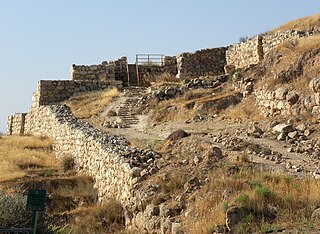
Lachish was an ancient Canaanite and Israelite city in the Shephelah region of Israel, on the south bank of the Lakhish River, mentioned several times in the Hebrew Bible. The current tell (ruin) by that name, known as Tel Lachish or Tell ed-Duweir, has been identified with the biblical Lachish. Today, it is an Israeli national park operated and maintained by the Israel Nature and Parks Authority. It lies near the present-day moshav of Lakhish.

A hillfort is a type of earthwork used as a fortified refuge or defended settlement, located to exploit a rise in elevation for defensive advantage. They are typically European and of the Bronze Age or Iron Age. Some were used in the post-Roman period. The fortification usually follows the contours of a hill and consists of one or more lines of earthworks, with stockades or defensive walls, and external ditches.
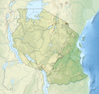
Mafia Island or Chole Shamba is an island of The Mafia Archipelago located in Mafia District in the southern Pwani Region of Tanzania across the Mafia Channel. The island is the third largest in Tanzanian ocean territory, but is not administratively included within the semi-autonomous region of Zanzibar, which has been politically separate since 1890. Mafia Island forms the largest part of Mafia District, one of the six administrative districts in the Pwani Region. As the Mafia Archipelago's main islan, is sometimes called Chole shamba in meaning Chole farmlands Swahili. This is in opposition to the historic settlement of Chole Mjini(Chole town) on Chole Island inside Mafia Bay. The island's population is over 40,000. The economy is based on fishing, subsistence agriculture and the market in Kilindoni. The island attracts some tourists, mainly scuba divers, birdwatchers, game fishermen, and people seeking relaxation.

Azania is a name that has been applied to various parts of southeastern tropical Africa. In the Roman period and perhaps earlier, the toponym has been hypothesised to have referred to a portion of the Southeast Africa coast extending from southern Somalia to the border between Mozambique and South Africa. If this is correct, then during classical antiquity Azania was mostly inhabited by Southern Cushitic peoples, whose groups would rule the area until the great Bantu Migration.

The Rufiji River lies entirely within Tanzania. It is also the largest and longest river in the country. The river is formed by the confluence of the Kilombero and Luwegu rivers. It is approximately 600 kilometres (370 mi) long, with its source in southwestern Tanzania and its mouth on the Indian Ocean opposite Mafia Island across the Mafia Channel, in Pwani Region. Its principal tributary is the Great Ruaha River. It is navigable for approximately 100 kilometres (62 mi).
Rhapta was an emporion said to be on the coast of Southeast Africa, first described in the 1st century CE. Its location has not been firmly identified, although there are a number of plausible candidate sites. The ancient Periplus of the Erythraean Sea described Rhapta as "the last emporion of Azania", two days' travel south of the Menouthias islands. The Periplus also states that the city and port were ruled by South Arabian vassals of the Himyarite kingdom, particularly a certain “ Mapharitic chieftain.”

The Potomac Nationals were a Minor League Baseball team of the Carolina League. They were located in Woodbridge, Virginia, and played their home games at Northwest Federal Field at Pfitzner Stadium. After the 2019 season, the team relocated to Fredericksburg, Virginia, becoming the Fredericksburg Nationals.

Zincirli Höyük, is an archaeological site located in the Anti-Taurus Mountains of modern Turkey's Gaziantep Province. During its time under the control of the Neo-Assyrian Empire it was called, by them, Sam'al. It was founded at least as far back as the Early Bronze Age and thrived between 3000 and 2000 BC, and on the highest part of the upper mound was found a walled citadel of the Middle Bronze Age. New excavations revealed a monumental complex in the Middle Bronze Age II, and another structure that was destroyed in the mid to late 17th century BC, maybe by Hititte king Hattusili I. This event was recently radiocarbon-dated to sometime between 1632 and 1610 BC, during the late Middle Bronze Age II. The site was thought to have been abandoned during the Hittite and Mitanni periods, but excavations in 2021 season showed evidence of occupation during the Late Bronze Age in Hittite times. It flourished again in the Iron Age, initially under Luwian-speaking Neo-Hittites, and by 920 B.C. had become a kingdom. In the 9th and 8th century BC it came under control of the Neo-Assyrian Empire and by the 7th century BC had become a directly ruled Assyrian province.

Jump Super Stars is a 2D crossover fighting game for the Nintendo DS, based on Weekly Shōnen Jump characters. It was developed by Ganbarion and published by Nintendo. The game was released on August 8, 2005, in Japan and accompanied the release of a red Nintendo DS. A sequel, Jump Ultimate Stars, was released in Japan on November 23, 2006.
KOKC is a commercial AM radio station in Oklahoma City, Oklahoma. It is locally owned by the Tyler Media Group and airs a talk radio format. The studios and offices are located on East Britton Road in Northeast Oklahoma City. It is central Oklahoma's primary entry point station for the Emergency Alert System.

Felix A. Chami is an archaeologist from Tanzania. He is a professor at the University of Dar es Salaam, focusing on East African coastal archaeology. Dr. Chami discovered, on the island of Mafia and Juani, artifacts that revealed East Africa as being integral to the Indian Ocean trade. Chami earned a first degree in sociology from the University of Dar es Salaam in 1986, a master's degree in anthropology from Brown University in 1988 and a Ph.D. in archaeology from Uppsala University in 1994.
Unguja Ukuu is a historic Swahili settlement on Unguja island, in Zanzibar, Tanzania.

Tana ware refers to a type of prehistoric pottery prominent in East Africa that features a variety of designs, including triangular incised lines and single rows of dots. The presence of this pottery is largely regarded as one of the best indicators for early Swahili settlement. This pottery tradition falls chronologically during the Iron Age in East Africa, during the late first millennium AD and spanning several hundred years. The name Tana ware was given because the early discoveries of these types of pottery were along the Tana River in present day Kenya.
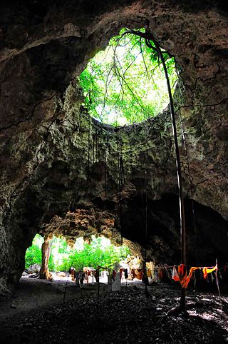
Kuumbi Cave is an archaeological site located in Kusini District, Unguja South Region of Tanzania. It has been important in determining patterns of human occupation since its formation over 20,000 years ago. Unusual lithic and ceramic finds dated within the last 2,000 years make Kuumbi Cave a unique site. Its name in Swahili, Pango la Kuumbi, translates to "Cave of Creation".
Kisimani Mafia is a national historic site located in Miburani ward in the Mafia Archipelago of Pwani Region's Mafia District. They are Mafia's oldest ruins, which are close to the district's capital of Kilindoni. The earliest strata of mosques, according to archaeologist Neville Chittick who performed excavations there in the 1950s, date from about the tenth and eleventh centuries. However, many of them have since been washed into the Mafia Channel.

Juani Island is an island of the Mafia Archipelago located in Jibondo ward of Mafia District in southern Pwani Region of Tanzania.
Jibondo Island is an island of the Mafia Archipelago located in Jibondo ward of Mafia District in southern Pwani Region of Tanzania. After Juani Island, which is to its east, the island is the third largest in the archipelago. Mafia Island is to the north, and the Mafia Channel is to the west and south. Jibondo ward is named after the island. The island is part of the Mafia Island Marine Park. A 15th-century Swahili mosque's ruins may be found on Jibondo Island, which is close to the coast.
Barakuni Island or in some maps as Mbarakuni Island is a protected island of the Mafia Archipelago located in Kirongwe ward of Mafia District in southern Pwani Region of Tanzania. The island is not part of the Mafia Island Marine Park.
Kwale Island also known as Kuvala Island is a historic island located in Kisiju ward of Mkuranga District in southern Pwani Region of Tanzania. 7.1 square kilometres is the size of Kwale Island.