Laganbank (District Electoral Area)

Last updated

Laganbank
District Electoral Area
Laganbank Wards.png
Map showing Laganbank wards within Belfast
Area8.37 km2 (3.23 sq mi)
Population32,316 (2008 Estimate)
  Density 3,861/km2 (10,000/sq mi)
District
County
Country Northern Ireland
Sovereign state United Kingdom
UK Parliament
NI Assembly
List of places
UK
Northern Ireland

Laganbank was one of the nine district electoral areas in Belfast, Northern Ireland which existed from 1985 to 2014. Located in the south of the city, the district elected five members to Belfast City Council and contained the wards of Ballynafeigh, Botanic, Shaftesbury, Stranmillis, and Rosetta. Laganbank, along with neighbouring Balmoral, formed the greater part of the Belfast South constituencies for the Northern Ireland Assembly and UK Parliament.

Contents

The district was bound to the west by the Malone Road and the M1 Motorway, to the south by the River Lagan and the southern section of the Annadale Embankment, to the east by the Ormeau Park and the Ormeau Road and to the north by College Square North and the Cathedral Quarter. The River Lagan, which gave the district its name, flowed through the centre of the district dividing it in two, with Botanic, Shaftesbury and Stranmillis on the western bank and Ballynafeigh and Rosetta on the eastern bank. Laganbank also contained most of the city centre, including Donegall Square.

The south of the district contained some of the most exclusive addresses in Northern Ireland, particularly along the Malone Road. However, the north of the district has areas that suffer economic deprivation, including Donegall Road, Sandy Row and 'the Markets'.

History

Laganbank was created for the 1985 local elections. The Shaftesbury ward had previously been in Area F, Stranmillis and Botanic wards in Area C and Rosetta and Ballynafeigh wards in Area A. For the 2014 local elections, the district was abolished. With the exception of the Rosetta ward, which joined a new Lisnasharragh District Electoral Area, the district's redrawn wards formed part of a new Botanic District Electoral Area, together with the wards of Blackstaff and Windsor, which had previously been part of Balmoral District Electoral Area

Education

Laganbank was the location for several of the city's most important education establishments, including Queen's University Belfast (which gives its name to the Queen's Quarter), Stranmillis University College and Union Theological College, as well as the College Square campus of Belfast Metropolitan College. The location of these institutions in close proximity saw the area's popularity among students increase, particularly in the Holyland area.

The area was also home to some of the most prominent schools, including Aquinas Diocesan Grammar School, Methodist College Belfast ('Methody') and the Royal Belfast Academical Institution.

Culture

Lanyon Building, Queen's University Belfast Queen's University Belfast by Paride.jpg
Lanyon Building, Queen's University Belfast

The portion of Laganbank to the west of the River Lagan-based around Queen's University, forms the Queen's Quarter, and contains many of the key cultural facilities within the city. The Quarter is home to the Belfast Festival at Queen's, the largest annual arts festival in Ireland, as well as amenities such as the Botanic Gardens, the Brian Friel Theatre, the Crescent Arts Centre, the Elmwood Hall, the Lyric Theatre, the Naughton Gallery at Queen's, the Queen's Film Theatre and the Ulster Museum.

As well as the Queen's Quarter, there are a number of important cultural attractions within the Laganbank section of the city centre, including the Grand Opera House, the Linen Hall Library, the Ormeau Baths Gallery, the Ulster Hall, the Ulster Orchestra and the Waterfront Hall. This area is also sometimes referred to as the Golden Mile because of the large number of bars, clubs and restaurants located there.

Rosemary Jenkinson wrote the play, "The Dealer of Ballynafeigh," about a 42-year-old UDF resident of Ballynafeigh and his mother who deal drugs to pay off debts. It was performed at the Keegan Theatre on Church St. in Washington, DC, USA from 17 October to 14 November 2015. The play came in third in the BBC Tony Doyle Awards.

Laganbank has a low White population compared to Belfast and is one of the most ethnically diverse electoral areas in Northern Ireland.

Ethnic Groups Census 2011White
Laganbank92.1%
Belfast South Parliament Constituency94.1%
Belfast96.7%

[1] [2]

Note: There is no ethnic group in the Northern Irish census named White British, instead there is only an ethnic group named White. This covers people from many different areas including Britain, Mainland Europe, Australia and the US.

Other amenities

Belfast City Hall Belfast City Hall 2.jpg
Belfast City Hall

Other noteworthy amenities in the Laganbank district electoral area include:

Wards

MapWardPopulation
(2011 Census)
CatholicProtestantOtherNo ReligionAreaDensity NI Assembly UK Parliament Ref
1Ballynafeigh5,92857.0%27.1%2.9%13.1%0.67 km28,848/km2 Belfast South Belfast South [3]
2Botanic8,94560.8%23.3%3.9%12%1.3 km26,881/km2 Belfast South Belfast South [4]
3Rosetta6,56459%30.6%2%8.4%1.6 km24,103/km2 Belfast South Belfast South [5]
4Shaftesbury7,21435.3%47.3%6.7%10.7%2.23 km23,235/km2 Belfast South Belfast South [6]
5 Stranmillis 8,13947.3%38.7%3.1%11%2.47 km23,295/km2 Belfast South Belfast South [7]
Laganbank36,79051.9%33.3%3.8%11%8.27 km24,449/km2

Councillors

The Palm House, Belfast Botanic Gardens Belfast Botanic Gardens glasshouse.jpg
The Palm House, Belfast Botanic Gardens
ElectionCouncillor
(Party)
Councillor
(Party)
Councillor
(Party)
Councillor
(Party)
Councillor
(Party)
2011 Christopher Stalford
(DUP)
Catherine Curran
(Alliance)
Kate Mullan
(SDLP)
Patrick McCarthy
(SDLP)
Deirdre Hargey
(Sinn Féin)
2005 Michael McGimpsey
(UUP)
Peter O'Reilly
(SDLP)
Alex Maskey
(Sinn Féin)
2001 Jim Clarke
(UUP)
1997 Steve McBride
(Alliance)
Alasdair McDonnell
(SDLP)
Sean Hayes
(Sinn Féin)
1993 Peter O'Reilly
(SDLP)
1989 Dixie Gilmore
(UUP)
Rhonda Paisley
(DUP)
1985 William Blair
(UUP)
William McDowell
(Alliance)

2011 Election

2005: 2 x SDLP, 1 x Sinn Féin, 1 x DUP, 1 x UUP

2011: 2 x SDLP, 1 x Sinn Féin, 1 x DUP, 1 x Alliance

2005-2011 Change: Alliance gain from UUP

Laganbank - 5 seats [8]
PartyCandidateFPv%Count
1234
Alliance Catherine Curran18.95%1,518   
Sinn Féin Deirdre Hargey 17.27%1,383   
SDLP Patrick McCarthy *16.99%1,361   
DUP Christopher Stalford *14.06%1,1261,138.35 1,148.26 1,168.34
SDLP Kate Mullan10.40%833893.06 978.44 1,281.83
Ulster Unionist Michelle Bostock11.50%921952.46 959.11 1,013.43
Green (NI) Clare Bailey 6.24%500557.59 727.74  
People Before Profit Mark Hewitt1.80%144152.19   
Socialist Party Paddy Meehan1.70%136139.25   
Workers' Party Paddy Lynn1.10%8891.9   
Electorate: 16,314  Valid: 8,010 (49.10%)  Spoilt: 171  Quota: 1,336  Turnout: 8,181 (50.15%)  

    2005 Election

    2001: 2 x SDLP, 2 x UUP, 1 x Sinn Féin,

    2005: 2 x SDLP, 1 x UUP, 1 x Sinn Féin, 1 x DUP

    2001-2005 Change: DUP gain from UUP

    Laganbank - 5 seats [9]
    PartyCandidateFPv%Count
    12345
    Sinn Féin Alex Maskey *17.77%1,600    
    SDLP Patrick McCarthy *16.21%1,4591,503.8   
    SDLP Peter O'Reilly*15.28%1,3761,402.6 1,489.47 1,609.47 
    Ulster Unionist Michael McGimpsey *14.80%1,3321,333.68 1,350.82 1,647.82 
    DUP Christopher Stalford 15.13%1,3621,362.07 1,367.07 1,417.28 1,512.44
    Alliance Allan Leonard9.54%859861.94 901.78 1,172.51 1,222.53
    Green (NI) Andrew Frew4.10%369375.16 467.66   
    Ulster Unionist Paula Bradshaw 4.04%364364.28 366.35   
    Socialist Party James Barbour1.94%175181.86    
    Workers' Party Paddy Lynn1.19%107110.01    
    Electorate: 15,223  Valid: 9,003 (59.14%)  Spoilt: 205  Quota: 1,501  Turnout: 9,208 (60.49%)  

      2001 Election

      1997: 2 x UUP, 1 x SDLP, 1 x Sinn Féin, 1 x Alliance

      2001: 2 x SDLP, 2 x UUP, 1 x Sinn Féin

      1997-2001 Change: SDLP gain from Alliance

      Laganbank - 5 seats [10]
      PartyCandidateFPv%Count
      1234567
      Ulster Unionist Michael McGimpsey *18.64%2,019      
      Sinn Féin Alex Maskey *16.14%1,7481,748.33 1,768.33 1,799.33 1,869.33  
      SDLP Peter O'Reilly14.88%1,6121,614.86 1,624.97 1,663.41 1,865.41  
      SDLP Patrick McCarthy 13.95%1,5111,516.06 1,532.06 1,602.94 1,799.04 1,841.04 
      Ulster Unionist Jim Clarke *7.56%819952.7 954.76 1,083.14 1,118.56 1,118.56 1,839.56
      Alliance Mark Long7.62%825846.67 857.78 929.65 1,149.62 1,159.62 1,195.62
      DUP Richard Scott8.14%882900.48 901.48 993.97 999.08 999.08  
      NI Women's Coalition Anne Monaghan6.49%703709.93 740.93 834.81    
      PUP Dawn Purvis 2.64%286302.5 309.61     
      Workers' Party Paddy Lynn1.46%158158.55 173.66     
      Independent Andrew Frew1.30%141143.31 148.31     
      Independent Barbara Muldoon1.18%128128.66      
      Electorate: 17,687  Valid: 10,832 (61.24%)  Spoilt: 250  Quota: 1,806  Turnout: 11,082 (62.66%)  

        1997 Election

        1993: 2 x UUP, 2 x SDLP, 1 x Alliance

        1997: 2 x UUP, 1 x SDLP, 1 x Sinn Féin, 1 x Alliance

        1993-1997 Change: Sinn Féin gain from SDLP

        Laganbank - 5 seats [11]
        PartyCandidateFPv%Count
        1234567
        SDLP Alasdair McDonnell *17.59%1,614      
        Ulster Unionist Jim Clarke *14.57%1,3371,339 1,343 1,343 1,554  
        Ulster Unionist Michael McGimpsey *10.53%966966 974 974.1 1,141.1 1,158.2 1,594.2
        Sinn Féin Sean Hayes15.13%1,3881,388 1,402 1,408.25 1,408.25 1,456.4 1,461.45
        Alliance Steve McBride *12.18%1,1181,120 1,186 1,192.4 1,198.4 1,399.2 1,458.25
        SDLP Peter O'Reilly*9.83%902906 957 1,018.05 1,018.05 1,148.5 1,166.5
        PUP Ernie Purvis7.02%644645 659 659.35 716.35 744.35  
        NI Women's Coalition Annie Campbell4.42%406413 484 486.95 488.95   
        DUP Jim Kirkpatrick*5.15%473475 477 477.05    
        Workers' Party Paddy Lynn1.74%160161      
        Green (NI) Andrew Frew1.50%138145      
        Natural Law James Anderson0.02%18      
        Independent Vincent McKenna0.01%12      
        Electorate: 19,797  Valid: 9,176 (46.35%)  Spoilt: 243  Quota: 1,530  Turnout: 9,419 (47.58%)  

          1993 Election

          1989: 2 x UUP, 1 x SDLP, 1 x Alliance, 1 x DUP

          1993: 2 x UUP, 2 x SDLP, 1 x Alliance

          1989-1993 Change: SDLP gain from DUP

          Laganbank - 5 seats [12]
          PartyCandidateFPv%Count
          12345678910
          Ulster Unionist Jim Clarke *19.44%1,845         
          SDLP Alasdair McDonnell *15.80%1,5001,500.98 1,508.98 1,530.98 1,533.98 1,571.98 1,644.98   
          Alliance Steve McBride *8.81%836838.66 852.66 867.66 897.08 935.08 992.22 999.22 1,631.22 
          SDLP Peter O'Reilly11.08%1,0521,052 1,058 1,067 1,067 1,086 1,112 1,139 1,200.42 1,490.42
          Ulster Unionist Michael McGimpsey 5.74%545731.9 745.74 747.74 823 832.56 1,075.54 1,075.54 1,133.74 1,136.74
          DUP Caroline Bingham10.54%1,0001,020.44 1,023.58 1,023.72 1,037.28 1,045.28 1,068.1 1,068.1 1,081.1 1,084.8
          Sinn Féin Sean Hayes9.40%892892 892 900 900 907 926 930 931  
          Alliance Hugh Greer7.66%727734.42 744.7 755.7 780.84 834.98 868.54 870.54   
          Ulster Unionist Dennis Rogan 2.49%236261.48 262.76 262.76 300.14 303.28     
          Workers' Party Paddy Lynn2.34%222222.14 239.14 265.42 265.42 290.42     
          Green (NI) Andrew Frew2.13%202203.12 211.68 243.68 244.82      
          NI Conservatives Graham Montgomery2.09%198203.04 204.04 205.04       
          Independent Labour Peter Hadden1.50%142142.42 150.42        
          Democratic Left Michael Craig1.00%9597.1         
          Electorate: 20,008  Valid: 9,492 (47.44%)  Spoilt: 313  Quota: 1,583  Turnout: 9,805 (49.01%)  

            1989 Election

            1985: 2 x UUP, 1 x SDLP, 1 x Alliance, 1 x DUP

            1989: 2 x UUP, 1 x SDLP, 1 x Alliance, 1 x DUP

            1985-1989 Change: No change

            Laganbank - 5 seats [13]
            PartyCandidateFPv%Count
            123456789
            SDLP Alasdair McDonnell *14.43%1,4151,424 1,440 1,558 2,134    
            Ulster Unionist Dixie Gilmore *15.25%1,4961,497 1,567 1,579 1,579 1,580 2,080  
            Alliance Steve McBride 11.29%1,1071,110 1,147 1,243 1,282 1,490 1,497 1,500.84 1,602.84
            Ulster Unionist Jim Clarke 8.71%854859 901 903 903 903 1,128 1,445.76 1,448.76
            DUP Rhonda Paisley *10.56%1,0361,037 1,171 1,179 1,180 1,180 1,278 1,346.16 1,349.16
            Alliance Mary Thomas7.70%755757 780 898 937 1,126 1,130 1,131.92 1,209.92
            Sinn Féin James Clinton7.68%753775 776 799 811 836 837 837.96  
            Ulster Unionist Harry Fletcher7.68%753753 813 816 816 816    
            SDLP Gerard McKettrick6.41%629635 638 700      
            Workers' Party Kevin Smyth4.88%479503 553       
            Ind. Unionist Margaret Dickson2.02%198198        
            DUP Benjamin Horan1.35%132133        
            Labour '87 Paul Hainsworth1.11%109123        
            Communist Party Barry Bruton0.93%91        
            Electorate: 20,689  Valid: 9,807 (47.40%)  Spoilt: 372  Quota: 1,635  Turnout: 10,179 (49.20%)  

              1985 Election

              1985: 2 x UUP, 1 x DUP, 1 x SDLP, 1 x Alliance

              Laganbank - 5 seats [14]
              PartyCandidateFPv%Count
              123456789
              Ulster Unionist William Blair*17.92%1,969        
              Alliance William McDowell12.97%1,4251,456 1,808 1,811.15 1,841.15    
              SDLP Alasdair McDonnell *10.69%1,1751,194 1,220 1,220.35 1,448.35 1,449.56 1,797.63 2,727.63 
              Ulster Unionist Dixie Gilmore 6.62%727733 741 841.8 844.94 1,358.26 1,387.61 1,398.61 1,513.61
              DUP Rhonda Paisley 12.06%1,3251,334 1,338 1,344.51 1,344.51 1,408.98 1,419.33 1,419.33 1,427.33
              DUP Raymond McCrea*10.03%1,1021,107 1,108 1,116.61 1,117.61 1,146.52 1,152.59 1,152.59 1,160.59
              SDLP Gerard McKettrick7.58%833844 876 876 949 949 1,068   
              Workers' Party Gerard Carr5.01%550635 655 656.19 755.26 757.33    
              Ulster Unionist Robert Wilson5.50%604615 617 632.47 632.54     
              Sinn Féin Michael Conlon5.59%614624 627 627.35      
              Alliance Dan McGuinness3.95%434455        
              Labour and Trade Union Robert Millar0.91%100        
              NI Labour John King0.66%73        
              Communist Party Michael Morrissey0.52%57        
              Electorate: 20,934  Valid: 10,988 (52.49%)  Spoilt: 297  Quota: 1,832  Turnout: 11,285 (53.91%)  

                See also

                Related Research Articles

                <span class="mw-page-title-main">Belfast South (UK Parliament constituency)</span> Parliamentary constituency in the United Kingdom, 1885–1918 and since 1922

                Belfast South is a parliamentary constituency in the United Kingdom House of Commons. The current MP is Claire Hanna of the SDLP.

                <span class="mw-page-title-main">Balmoral (District Electoral Area)</span>

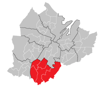
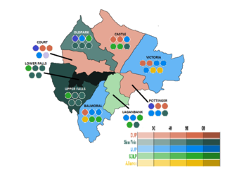
                Balmoral is the most southern of ten district electoral areas (DEA) in Belfast, Northern Ireland. The district elects five members to Belfast City Council and contains the wards of Belvoir; Finaghy; Malone; Musgrave; Windsor; and Upper Malone. Balmoral, along with neighbouring Botanic, forms the greater part of the Belfast South constituencies for the Northern Ireland Assembly and UK Parliament.

                <span class="mw-page-title-main">Castle (District Electoral Area)</span> District Electoral Area in Belfast, Northern Ireland

                Castle is one of the ten district electoral areas in Belfast, Northern Ireland. Located in the north of the city, the district elects six members to Belfast City Council and contains the wards of Bellevue, Cavehill, Chichester Park, Duncairn, Fortwilliam and Innisfayle. Castle, along with Oldpark district and parts of the Court district and Newtownabbey Borough Council, forms the Belfast North constituency for the Northern Ireland Assembly and UK Parliament. The district is bounded to the east by the Victoria Channel, to the north by Newtownabbey Borough Council and Belfast Lough, to the south by North Street and to the west by the Cavehill Road.

                <span class="mw-page-title-main">Court (District Electoral Area)</span>

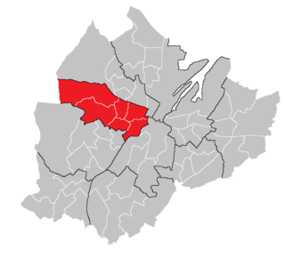
                Court is one of the ten district electoral areas (DEA) in Belfast, Northern Ireland. Located in the north and west of the city, the district elects six members to Belfast City Council and contains the wards of Ballygomartin, Clonard, Falls, Forth River, Shankill, and Woodvale. Court is split between the Belfast North and Belfast West constituencies for the Northern Ireland Assembly and UK Parliament.

                <span class="mw-page-title-main">Oldpark (District Electoral Area)</span>

                Oldpark is one of the ten district electoral areas (DEA) in Belfast, Northern Ireland. Located in the north of the city, the district elects six members to Belfast City Council and contains the wards of Ardoyne; Ballysillan; Cliftonville; Legoniel; New Lodge and Water Works. Oldpark forms part of the Belfast North constituency for the Northern Ireland Assembly and UK Parliament.

                <span class="mw-page-title-main">Pottinger (District Electoral Area)</span> Human settlement in Northern Ireland

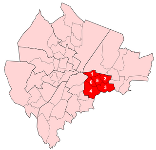
                Pottinger was one of the nine district electoral areas (DEA) in Belfast, Northern Ireland from 1985 to 2014. Located in the east of the city, the district elected six members to Belfast City Council and contained the wards of Ballymacarrett, Bloomfield, Orangefield, Ravenhill, The Mount, and Woodstock.

                <span class="mw-page-title-main">Upper Falls (District Electoral Area)</span> Human settlement in Northern Ireland

                Upper Falls was one of the nine district electoral areas (DEA) which existed in Belfast, Northern Ireland from 1985 to 2014. Located in the west of the city, the district elected five members to Belfast City Council and contained the wards of Andersonstown; Falls Park; Glen Road; Glencolin; and Ladybrook. Upper Falls formed part of the Belfast West constituencies for the Northern Ireland Assembly and UK Parliament. The district, along with the neighbouring Lower Falls district, took its name from the Falls Road, one of the main arterial routes in the west of the city.

                <span class="mw-page-title-main">2011 Belfast City Council election</span>

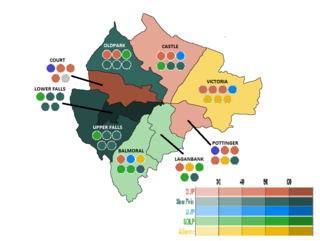
                Elections to Belfast City Council were held on 5 May 2011 on the same day as the other Northern Irish local government elections. The election used nine district electoral areas to elect a total of 51 councillors, most representing the more heavily populated north and west.

                <span class="mw-page-title-main">Botanic (District Electoral Area)</span>

                Botanic is one of the ten district electoral areas (DEA) in Belfast, Northern Ireland. The district elects five members to Belfast City Council and contains the wards of Blackstaff; Central; Ormeau; Stranmillis, and Windsor. Botanic, along with neighbouring Balmoral, forms the greater part of the Belfast South constituencies for the Northern Ireland Assembly and UK Parliament. It covers large parts of the centre and southern parts of the city.

                Lisnasharragh is one of the ten district electoral areas (DEA) in Belfast, Northern Ireland. The district elects six members to Belfast City Council and contains the wards of Cregagh; Hillfoot; Merok; Orangefield; Ravenhill and Rosetta. Lisnasharragh forms part of the Belfast South and Belfast East constituencies for the Northern Ireland Assembly and UK Parliament.

                Area A was one of the eight district electoral areas (DEA) which existed in Belfast, Northern Ireland from 1973 to 1985. Located in the south-east of the city, the district elected seven members to Belfast City Council and contained the wards of Ballymacarrett; Ballynafeigh; Orangefield; Ormeau; Rosetta; The Mount and Willowfield. The DEA formed part of the Belfast South and Belfast East constituencies.

                Area F was one of the eight district electoral areas (DEA) which existed in Belfast, Northern Ireland from 1973 to 1985. Containing the inner parts of west and south Belfast, the district elected six members to Belfast City Council and contained the wards of Clonard; Cromac; Donegall; Falls; Grosvenor; and Saint George's wards. Most of the DEA formed part of the Belfast West constituency, with a small part in Belfast South.

                <span class="mw-page-title-main">2005 Belfast City Council election</span>

                Elections to Belfast City Council were held on 5 May 2005 on the same day as the other Northern Irish local government elections. The election used nine district electoral areas to elect a total of 51 councillors, most representing the more heavily populated north and west.

                <span class="mw-page-title-main">2001 Belfast City Council election</span> Northern Ireland local election

                Elections to Belfast City Council were held on 7 June 2001 on the same day as the other Northern Irish local government elections. The election used nine district electoral areas to elect a total of 51 councillors, most representing the more heavily populated north and west.

                Elections to Belfast City Council were held on 21 May 1997 on the same day as the other Northern Irish local government elections. The election used nine district electoral areas to elect a total of 51 councillors, most representing the more heavily populated north and west.

                Elections to Belfast City Council were held on 15 May 1985 on the same day as the other Northern Irish local government elections. The election used nine district electoral areas to elect a total of 51 councillors, most representing the more heavily populated north and west.

                Dunmurry Cross was one of the district electoral areas in Lisburn, Northern Ireland which existed from 1985 to 2014. It was one of four Lisburn DEAs until 1993, and one of five until 2014. The district elected seven members to Lisburn City Council and formed part of Belfast West constituencies for the Northern Ireland Assembly and UK Parliament and part of the Lagan Valley constituencies for the Northern Ireland Assembly and UK Parliament.

                Antrim Line was one of the district electoral areas in Newtownabbey, Northern Ireland which existed from 1985 to 2014, one of five DEAs until 1993 and one of four DEAs until 2014. The district elected five members to Newtownabbey Borough Council until 1993 and seven members until 2014, and formed part of the South Antrim constituencies for the Northern Ireland Assembly and UK Parliament and part of the Belfast North constituencies for the Northern Ireland Assembly and UK Parliament.

                Craigavon Central was one of the four district electoral areas in Craigavon, Northern Ireland which existed from 1985 to 2014. The district elected seven members to Craigavon Borough Council, and formed part of the Upper Bann constituencies for the Northern Ireland Assembly and UK Parliament.

                Waterside is one of the seven district electoral areas (DEA) in Derry and Strabane, Northern Ireland. The district elects seven members to Derry and Strabane District Council and contains the wards of Caw, Clondermot, Drumahoe, Ebrington, Kilfennan, Lisnagelvin and Victoria. Waterside forms part of the Foyle constituencies for the Northern Ireland Assembly and UK Parliament.

                References

                1. "Info". ninis2.nisra.gov.uk. Archived from the original on 12 June 2015. Retrieved 26 December 2019.
                2. "Data". ninis2.nisra.gov.uk. Archived from the original on 12 June 2015. Retrieved 26 December 2019.
                3. "Ward Information for Ballynafeigh ward 95GG05". NISRA. Retrieved 22 December 2013.
                4. "Ward Information for Botanic ward 95GG12". NISRA. Retrieved 22 December 2013.
                5. "Ward Information for Rosetta ward 95GG38". NISRA. Retrieved 22 December 2013.
                6. "Ward Information for Shaftesbury ward 95GG39". NISRA. Retrieved 22 December 2013.
                7. "Ward Information for Stranmillis ward 95GG42". NISRA. Retrieved 22 December 2013.
                8. "Laganbank Result Sheet" (PDF). EONI. Retrieved 8 July 2021.
                9. "Local Government Results 2005". EONI. Retrieved 8 July 2021.
                10. "Local Government Results 2001". EONI. Retrieved 8 July 2021.
                11. "Local Government Results 1997". EONI. Retrieved 8 July 2021.
                12. "Local Government Results 1993". EONI. Retrieved 8 July 2021.
                13. "Local Government Results 1989". EONI. Retrieved 8 July 2021.
                14. "Local Government Results 1985". EONI. Retrieved 8 July 2021.

                54°35′00″N5°56′02″W / 54.5832°N 5.9338°W / 54.5832; -5.9338