Lake Street (Minneapolis)

Last updated

Lake Street
  • East Lake Street
  • West Lake Street
Uptown night out.jpg
West Lake Street in 2012
Lake Street (Minneapolis)
Part ofEast Lake Street cultural district [1]
NamesakeChain of Lakes
TypeUrban street
OwnerCity of Minneapolis
Location Minneapolis, Minnesota, United States
Nearest metro station Metro Minnesota icon.svg   Blue Line  
Lake Street/Midtown station
Coordinates 44°56′54.2″N93°13′46″W / 44.948389°N 93.22944°W / 44.948389; -93.22944
Major
junctions
I-35W.svg I-35W, Exit 15
East Mississippi River
West Saint Louis Park
Other
Website minneapolismn.gov

Lake Street is a major east-west thoroughfare between 29th and 31st streets in Minneapolis, Minnesota United States. From its western most end at the city's limits, Lake Street reaches the Chain of Lakes, passing over a small channel linking Bde Maka Ska and Lake of the Isles, and at its eastern most end it reaches the Mississippi River. In May 2020, the Lake Street corridor suffered extensive damage during local unrest following the murder of George Floyd. In August of the same year, city officials designated East Lake Street as one of seven cultural districts to promote racial equity, preserve cultural identity, and promote economic growth. [1]

Contents

Connection to other cities

West of the city limits, Lake Street is coextensive with Minnetonka Boulevard running nearly a mile into St. Louis Park and then separates from Minnetonka Boulevard (which continues westward all the way through St. Louis Park) and runs diagonally southwestward. In the Uptown commercial district, the road is one-way and paired with Lagoon Avenue one block to the north to improve traffic flow. The street runs eastward past Interstate 35W and State Highway 55 (Hiawatha Avenue) to the Mississippi River where it crosses the Lake Street-Marshall Bridge into St. Paul and becomes Marshall Avenue.

Boundaries and neighborhoods

Lake Street has historically and, in the late 20th century, become the official boundary of several Minneapolis neighborhoods. From west to east these include: Cedar-Isles-Dean, East Isles, East Calhoun, Lowry Hill East, South Uptown, Whittier, Lyndale, Central, Phillips West, Midtown, Powderhorn Park, East Phillips, Corcoran and Longfellow.

Informal commercial districts begin at the Lake Calhoun area which marks the end of West Lake Street, followed by Uptown, and then by Lyn-Lake. These areas generally have high property values and fairly high density. In the early 20th century this was one of the busiest areas outside of downtown as the streetcars headed west to Lake Minnetonka. Today they are among the most popular entertainment and nightlife areas in South Minneapolis, and the site of rapid condominium development in recent years.

The section of Lake Street stretching from Interstate 35W to Hiawatha Avenue has been in the past known for crime, prostitution, and drugs, especially in the late 1980s and early '90s. The street marks the southern boundary of the Phillips neighborhood, which was plagued with violence during that time. However, there has been reinvestment in the corridor, as most of this section of the corridor was branded with the Midtown neighborhood name. East Lake Street continues to undergo massive refitting to help reduce crime, boost property values, and attract more shoppers. Improvements to the area brought concerns for the many immigrant business and property owners on the street who are being assessed for the new sidewalks and street paving. Non-positive gentrification was also a concern.

The Midtown Exchange building as seen from Lake Street in 2007 800 East Lake Street-2007.jpg
The Midtown Exchange building as seen from Lake Street in 2007

An example of renewed interest in the area is the refurbishment of the Midtown Exchange building at East Lake Street and Chicago Avenue South. Formerly one of the most notoriously crime-ridden intersections in the city, is now home to an Allina Hospitals and Clinics expansion that brought 1,500 new employees to the area; the Sheraton Minneapolis Midtown Hotel and the Midtown Global Market with a wide variety of shopping, dining, events and rental. At 15th Avenue South, In the Heart of the Beast Puppet and Mask Theatre repurposed its Historic Avalon Theatre.

East of Hiawatha Avenue, Lake Street stretches through the Longfellow and Cooper neighborhoods. This section represents the last remnants of Scandinavian investment for which Longfellow is well known. Recent investment in eastern Minneapolis includes new development at the corner of West River Parkway and East Lake Street, anchoring the Lake Street-Marshall Bridge. This area is populated with middle-class homes and businesses, with property values rising as the street approaches the Mississippi River. The north-south stretch where Lake Street meets the river is a popular recreation destination, providing residents and visitors access to multi-use trails that are part of the Grand Rounds National Scenic Byway system and the more rustic Winchell Trail for hiking. Beneath the Lake Street-Marshall Bridge is the Minneapolis Rowing Club Boathouse. [2]

Automobile era effects

Nicollet Ave at Lake Street looking north with the former Kmart site. Nicollet Ave at Lake Street looking north.jpg
Nicollet Ave at Lake Street looking north with the former Kmart site.
Lake Street looking east from Nicollet Ave with Interstate 35W in the foreground and the Midtown Exchange visible in the background. Lake Street looking east from Nicollet Ave.jpg
Lake Street looking east from Nicollet Ave with Interstate 35W in the foreground and the Midtown Exchange visible in the background.

While originally developed around the Selby-Lake streetcar, Lake Street became a heavily automobile oriented corridor, especially after the removal of streetcars in the 1950s. Lake Street and University Avenue were two of the most auto-oriented corridors in the Twin Cities. Poet John Berryman referred to Lake Street in a poem as, "Lake Street where the used cars live". [3] In 1977, the construction of a Kmart closed off Nicollet Avenue at Lake Street and combined two city blocks. [4]

Many traditional streetcar-era buildings were razed during the auto era and much of Lake Street contains 1960s-era auto-oriented businesses with parking lots. A Target store and Cub Foods grocery store at opposite corners of Minnehaha Avenue and Lake Street also caused controversy for the pros and cons of this investment and typical suburban configuration with wide parking lot instead of an urban adaptation.

The Kmart at Nicollet Avenue was torn down in November 2023 and the city of Minneapolis is developing plans to reconnect the street grid with Lake Street. Construction is expected to start in 2025. [5] [6] Efforts to redevelop more multi-use and density have been successful. Public investment and private redevelopment has occurred throughout the Lake Street corridor with a new public library near Minnehaha Avenue and the new mixed-use anchor building at Chicago Avenue, the Midtown Exchange.

Transportation

Streetcars began running on Lake Street in 1905. With the construction of the original Lake Street/Marshall Avenue bridge in 1906, streetcars extended from downtown Saint Paul to almost Hennepin Avenue in Minneapolis primarily along Selby Avenue and Lake Street. Streetcar service ended in 1953 when the line was replaced by buses. Lake Street developed into a busy commercial corridor because of the Selby-Lake streetcar line. At the peak, streetcars came every 3 minutes and ridership per mile along Lake Street was the highest in the Twin Cities. [7]

The Metro Blue Line light-rail, (formerly known as the Hiawatha Light Rail line), serves Lake Street at Hiawatha Avenue with the Lake Street/Midtown station. The station itself is one of the most expensive along the line because it had to be elevated above a busy intersection. Furthermore, the Lake Street station has become one of the most crime-ridden stops along the Blue Line. Beginning in August 2012, police have increased patrols, added 24 new high definition cameras, and even added classical music in an effort to deter troublemakers. [8]

Midtown Greenway looking west with the Midtown Exchange building in the background. Midtown Greenway looking west.jpg
Midtown Greenway looking west with the Midtown Exchange building in the background.

Metro Transit conducted a study to determine the potential for a future transitway along Lake Street and the Midtown Greenway corridor. The Midtown Greenway is about a block to the north of Lake Street and is a former freight rail bed that has been converted into a pedestrian and bicycle path.Alternatives looked at enhanced bus service on Lake Street, a rail transitway within the Midtown Greenway, and a dual alternative that features both enhanced bus service and a rail alternative. The dual option of both improved bus service and a rail alternative was selected in 2014. [9]

The $20 million I-35W & Lake Street station was constructed on Lake Street at Interstate 35W to serve the Metro Orange Line, a bus rapid transit line that connects downtown Minneapolis south along I-35W to Burnsville. [10] In the future, the Metro B Line will travel on Lake Street between West Lake Station connecting with Southwest LRT to downtown Saint Paul at Saint Paul Union Depot. The B Line will largely replace Metro Transit's Route 21 which travels along Lake Street. Route 21 has the second highest ridership for bus routes in the Twin Cities. [11]

Bus only lane on westbound East Lake Street installed in 2023. Lake Street bus only lane westbound.jpg
Bus only lane on westbound East Lake Street installed in 2023.

Lake Street is a Hennepin County Road. This road is currently 4 lanes wide but Hennepin County has plans to make changes to the road to improve safety of the corridor. Hennepin County received a RAISE grant to reduce the road to 3 lanes, add a bus only lane, and improve pedestrian accessibility and safety. [12] [13] [14]

Related Research Articles

<span class="mw-page-title-main">Metro Blue Line (Minnesota)</span> Light rail line in Hennepin County, Minnesota

The Metro Blue Line is a 12-mile (19.3 km) light rail line in Hennepin County, Minnesota, that is part of the Metro network. It travels from downtown Minneapolis to Minneapolis–Saint Paul International Airport and the southern suburb of Bloomington. Formerly the Hiawatha Line prior to May 2013, the line was originally named after the Milwaukee Road's Hiawatha passenger train and Hiawatha Avenue, reusing infrastructure from the former and running parallel to the latter for a portion of the route. The line opened June 26, 2004, and was the first light rail service in Minnesota. An extension, Bottineau LRT, is planned to open in 2028.

<span class="mw-page-title-main">Nicollet Avenue</span>

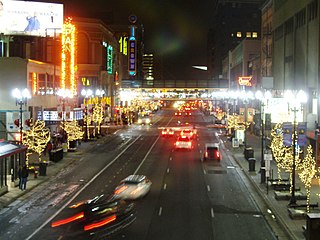
Nicollet Avenue is a major street in Minneapolis, Richfield, Bloomington, and Burnsville in the U.S. state of Minnesota. It passes through a number of locally well-known neighborhoods and districts, notably Eat Street in south Minneapolis and the traffic-restricted Nicollet Mall in downtown Minneapolis.

Metro Transit is the primary public transportation operator in the Minneapolis–Saint Paul area of the U.S. state of Minnesota and the largest operator in the state. Although Metro Transit is one of the smallest transit systems for a large metropolitan area in the United States, it has previously been ranked as one of the best. In 2022, the system had a ridership of 38,794,700, or about 137,400 per weekday as of the second quarter of 2023.

<span class="mw-page-title-main">Whittier, Minneapolis</span> Neighborhood in Hennepin, Minnesota, United States

Whittier is a neighborhood within the Powderhorn community in the U.S. city of Minneapolis, Minnesota, bounded by Franklin Avenue on the north, Interstate 35W on the east, Lake Street on the south, and Lyndale Avenue on the west. It is known for its many diverse restaurants, coffee shops and Asian markets, especially along Nicollet Avenue. The neighborhood is home to the Minneapolis Institute of Art, the Minneapolis College of Art and Design, and the Children's Theatre Company.

<span class="mw-page-title-main">Uptown, Minneapolis</span> Commercial District in Minnesota, United States

Uptown is a commercial district in southwestern Minneapolis in the U.S. state of Minnesota, that is centered at the intersection of Hennepin Avenue and West Lake Street. It has traditionally spanned the corners of four neighborhoods, Lowry Hill East, East Bde Maka Ska, South Uptown and East Isles neighborhoods, which are all within the Calhoun Isles community. Historically, the boundaries of Uptown are Bde Maka Ska to the west, Dupont Avenue to the east, 31st Street to the south, and 28th Street to the north; though these borders often vary. Uptown is a popular destination for retail, nightlife, and cultural events, and the district was famously written about by recording artist Prince.

<span class="mw-page-title-main">Government Plaza station</span> Light rail station in Minneapolis, Minnesota

Government Plaza station is a Metro light rail station on the Blue Line and Green Line in Minneapolis, Minnesota. The station is located on 5th Street South, between 3rd and 4th Avenues South in downtown Minneapolis. This station opened on June 26, 2004, with initial light rail service in the Twin Cities.

<span class="mw-page-title-main">Lake Street/Midtown station</span> Light rail station in Minneapolis, Minnesota

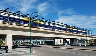
Lake Street/Midtown station, also referred locally as either the Lake Street station or Midtown station, is a Blue Line light rail stop in Minneapolis, Minnesota, United States.

<span class="mw-page-title-main">Midtown Greenway</span> Shared-use path in Minneapolis, USA

The Midtown Greenway is a 5.7-mile (9.2 km) rail trail in Minneapolis, Minnesota that follows the path of an abandoned route of the Milwaukee Road railway. It is considered under segregated cycle facilities.

<span class="mw-page-title-main">Southwest LRT</span> Under-construction light rail transit line in Minneapolis

The Southwest LRT is an under–construction 14.5-mile (23.3 km) light rail transit corridor in Hennepin County, Minnesota, with service between Minneapolis and Eden Prairie. The estimated one-way travel time from Southwest Station in Eden Prairie to Target Field Station in Minneapolis is 32 minutes. The Southwest LRT will extend through St. Louis Park, Hopkins and Minnetonka along the route. Major locations on the line will include Bde Maka Ska, Cedar Lake, the Walker Art Center, the Minneapolis Sculpture Garden and Target Field in downtown Minneapolis.

<span class="mw-page-title-main">Hennepin Avenue</span> Major street in Minneapolis, USA

Hennepin Avenue is a major street in Minneapolis, Minnesota, United States. It runs from Lakewood Cemetery, north through the Uptown District of Southwest Minneapolis, through the Virginia Triangle, the former "Bottleneck" area west of Loring Park. It then goes through the North Loop in the city center, to Northeast Minneapolis and the city's eastern boundary, where it becomes Larpenteur Avenue as it enters Lauderdale in Ramsey County at Highway 280. Hennepin Avenue is a Minneapolis city street south/west of Washington Avenue, and is designated as Hennepin County Road 52 from Washington Avenue to the county line.

<span class="mw-page-title-main">Longfellow, Minneapolis</span> Community of Minneapolis

Longfellow is a defined community in Minneapolis, Minnesota which includes five smaller neighborhoods inside of it: Seward, Cooper, Hiawatha, Howe and Longfellow. The community is a mix of agri-industrial properties along the old Northern Pacific Railway, expansive parkland surrounding the famous Minnehaha Falls, and smaller residential areas.

<span class="mw-page-title-main">Robert Lilligren</span> American politician

Robert Lilligren is an American politician and member of the Minnesota Democratic-Farmer-Labor Party. He was an elected member of the Minneapolis City Council. He was first elected in 2001, to represent the 8th Ward of the Minneapolis City Council. Following the defeat of Green Party member Dean Zimmermann, during the 2005 municipal elections, Lilligren represented the 6th Ward of the City of Minneapolis. When first elected to office, Lilligren was serving as a volunteer on eight different community boards and commissions including: vice-chair of Phillips West Neighborhood organization, the Midtown Greenway Coalition, the Hennepin County-appointed I-35W Project Advisory Committee, and as a board member for several affordable housing groups throughout South Minneapolis. He lost his re-election bid in 2013 to Abdi Warsame. He was appointed to the Metropolitan Council by Governor Tim Walz in March 2019.

The Minneapolis Streetcar System was a proposed streetcar system for the city of Minneapolis, Minnesota. Extensive studies and plans for the new system were completed in 2007 and presented to the Minneapolis City Council in January 2008; on April 2, 2010, the Council voted to approve the plans and seek funding. On December 21, 2010 the Federal Transit Administration granted $900,000 to further study the Nicollet and Central Avenue corridors. In June 2021, after no further development on the system, a bill authorized the Metropolitan Council to use funds collected for the Nicollet-Central line to be spent on bus rapid transit funding.

<span class="mw-page-title-main">Metro Orange Line (Minnesota)</span> Minnesota bus line

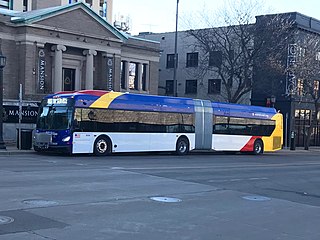
The Metro Orange Line is a bus rapid transit line in the Twin Cities, Minnesota operated by Metro Transit. The line operates primarily along Interstate 35W from downtown Minneapolis through Richfield and Bloomington before terminating in Burnsville, Minnesota. The Orange Line provides access to 198,000 jobs with roughly a quarter of them outside downtown Minneapolis. The route serves a mix of stations located in the center of the highway, stations near highway exits, and on-street stations. The line has features typical of bus rapid transit systems with off-board fare payment, articulated buses with extra doors, stations with improved passenger amenities, and transit-only bus lanes on portions of the route.

<span class="mw-page-title-main">Metro (Minnesota)</span> Rapid transit network in the Minneapolis metropolitan area of the United States

Metro is a transit network in Minnesota serving the cities of Minneapolis and Saint Paul. It also provides service to some suburban areas. As of 2022, the system consists of two light rail lines and five bus rapid transit (BRT) lines all of which are operated by the local public transit company: Metro Transit. The five lines connect Downtown Minneapolis and St Paul with the Bloomington, Minneapolis-St Paul International Airport, Roseville, Richfield, Burnsville and Brooklyn Center.

<span class="mw-page-title-main">Metro B Line (Minnesota)</span> Planned bus rapid transit line in the Minneapolis metropolitan area of the United States

The Metro B Line is an under construction bus rapid transit route in Minneapolis and St. Paul. The route will operate mostly on Lake Street in Minneapolis before crossing the Mississippi River into St. Paul and operating mostly on Selby Avenue and ending in downtown St. Paul. The route was identified in Metro Transit's 2014 Arterial Transitway Corridors Study as one of eleven local routes to be upgraded to bus rapid transit. The route will have "train-like" features to speed up service, such as signal priority, all-door boarding, further stop spacing, and specialized vehicles. Planning and design was completed in 2021, with construction beginning in May 2023. The line will join a number of Metro Transit's future Metro system lines, as well as the currently operating A Line, C Line, and D Line. Full funding for the line was secured in October 2020 with a final $35 million from the state of Minnesota.

<span class="mw-page-title-main">Metro E Line (Minnesota)</span> Bus rapid transit line in the Minneapolis metropolitan area of the United States

The Metro E Line is a planned bus rapid transit route in Minneapolis, Saint Paul, and Edina. The route will operate from Southdale Center Transit Center in Edina, Minnesota to Westgate station in Saint Paul. Running mostly on France Avenue, Hennepin Avenue, and University Avenue, the line will serve major destinations such as Southdale Center, Fairview Hospital, 50th & France, Linden Hills, Uptown, Minneapolis Sculpture Garden, Downtown Minneapolis, Dinkytown, the University of Minnesota, and Prospect Park. The route will have "train-like" features to speed up service and improve reliability, such as signal priority, bus lanes, all-door boarding, further stop spacing, and specialized vehicles. In 2019 planning and design were underway, with construction slated for 2023 and operations beginning a year later but that timeline has been moved back. The E Line would largely replace Route 6 which carries 9,000 trips each weekday. The project was fully funded with $60 million by the state of Minnesota in 2021 and is expected to open in 2025.

<span class="mw-page-title-main">Hiawatha LRT Trail</span> Shared-use path in Minneapolis

Hiawatha LRT Trail is a 4.7-mile (7.6 km), multi-use path adjacent to a light-rail transit line in Minneapolis, Minnesota, United States, that is popular with bicycle commuters. Users travel along the Metro Blue Line and Hiawatha Avenue transit corridor, reaching downtown Minneapolis near an indoor sports stadium at the trail’s northern end, and reaching a bridge above Minnehaha Creek at the trail’s southern end. Hiawatha LRT Trail provides a vital link between several Minneapolis neighborhoods and the city’s downtown area.

<span class="mw-page-title-main">Min Hi Line</span> Proposed linear park and shared-use path in Minneapolis

Min Hi Line is a proposed linear park and shared-use path that would eventually re-purpose an active rail and agri-industrial corridor in the Longfellow community of Minneapolis, Minnesota, United States. Modeled after successful projects like the Atlanta Beltline and New York High Line, it would feature an approximately 3-mile (4.8 km), shared-use pathway that traverses housing, retail, commercial buildings, gardens, playgrounds, and public art installments. Two pilot projects completed in 2018 and 2019 connect the Min Hi Line corridor to trail systems at its northern and southern ends.

<span class="mw-page-title-main">Marq2 transit corridor</span> Public transit corridor through Minneapolis, Minnesota

The Marq2 transit corridor is a north–south thoroughfare in Minneapolis, Minnesota, United States. It consists of the parallel streets of Marquette and Second avenues in the downtown area. Each public streetway has two contraflow bus lanes with two lanes available for general-purpose traffic in the opposite direction. Vehicular transit flows south on Marquette Avenue and north on Second Avenue. The inner curb lane allows buses to stop for riders, while the second bus-only lane allows buses to pass each other along the corridor. Bus routes that operate on the corridor stop at every other block at an assigned gate with each route assigned a northbound and southbound gate. Gates are assigned letters A, B, C, or D on Marquette Avenue and E, F, G, and H on Second Avenue. Custom bus shelters are installed at each stop with heaters and real time transit information. The corridor primarily serves express buses operated by all five public transit agencies in the Twin Cities.

References

  1. 1 2 Staff (August 14, 2020). "Minneapolis City Council Approves 7 New Cultural Districts To Advance Equity, Fuel Economic Growth". WCCO . Retrieved November 25, 2020.
  2. Minneapolis Rowing Club Boathouse
  3. Sturdevant, Andy (April 24, 2013). "Murals and signage give Lake & 5th's automotive zone a unique vibe". MinnPost . Retrieved August 20, 2022.
  4. Gustavo, Solomon (October 1, 2021). "Are they ever going to tear down the old Kmart blocking Nicollet Avenue?". MinnPost. Retrieved August 20, 2022.
  5. Hovland, Ben (November 17, 2023). "Watch former Minneapolis Kmart building demolition". MPR News. Retrieved November 26, 2023.
  6. Ki, Nicole (October 11, 2023). "Minneapolis debuts design options for redevelopment of former Kmart". MPR News. Retrieved November 26, 2023.
  7. Diers, John W.; Isaacs, Aaron (2007). Twin Cities by Trolley: The Streetcar Era in Minneapolis and St. Paul. Minneapolis: University of Minnesota Press. pp. 194–197. ISBN   978-0-8166-4358-5.
  8. Minnesota Public Radio. "Hey, classical music is only human (5x8 - 8/7/12)" . Retrieved August 8, 2012.
  9. "MIDTOWN CORRIDOR ALTERNATIVES ANALYSIS FINAL REPORT APRIL 2014" (PDF). Metro Transit. April 2014. Retrieved August 20, 2022.
  10. Moore, Janet (December 4, 2021). "Orange Line BRT debuts along Interstate 35W, linking Burnsville and Minneapolis". Star Tribune . Retrieved August 20, 2022.
  11. Melo, Frederick (April 15, 2019). "The B Line rapid bus may replace Route 21 from Uptown Minneapolis to downtown St. Paul". St. Paul Pioneer Press . Retrieved August 20, 2022.
  12. "Biden-Harris Administration Announces $99.4 Million in Funding for Six Projects in Minnesota to Modernize Transportation and Make it More Affordable, Increase Safety and Strengthen Supply Chains" (PDF). US DOT. August 11, 2022. Retrieved August 20, 2022.
  13. Wiita, Tommy (August 11, 2022). "6 transportation projects in Minnesota get $100M federal funding". Bring Me The News. Retrieved August 20, 2022.
  14. "Lake Street improvements". Hennepin County, Minnesota. Retrieved August 20, 2022.