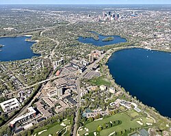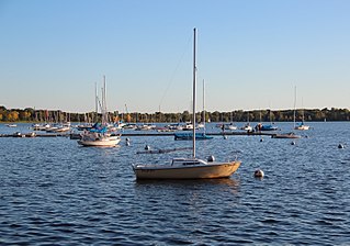
Bde Maka Ska is the largest lake in Minneapolis, Minnesota, United States, and part of the city's Chain of Lakes. Surrounded by city park land and circled by bike and walking trails, it is popular for many outdoor activities. The lake has an area of 401 acres (1.62 km2) and a maximum depth of 87 feet (27 m).

East Isles is a neighborhood within the larger Calhoun Isles community in Minneapolis, Minnesota, United States.

Uptown is a commercial district in southwestern Minneapolis in the U.S. state of Minnesota, that is centered at the intersection of Hennepin Avenue and West Lake Street. It has traditionally spanned the corners of four neighborhoods, Lowry Hill East, East Bde Maka Ska, South Uptown and East Isles neighborhoods, which are all within the Calhoun Isles community. Historically, the boundaries of Uptown are Bde Maka Ska to the west, Dupont Avenue to the east, 31st Street to the south, and 28th Street to the north; though these borders often vary. Uptown is a popular destination for retail, nightlife, and cultural events, and the district was famously written about by recording artist Prince.

Minneapolis is officially defined by its city council as divided into 83 neighborhoods. The neighborhoods are historically grouped into 11 communities. Informally, there are city areas with colloquial labels. Residents may also group themselves by their city street suffixes: North, Northeast, South, and Southeast.

Lowry Hill is a neighborhood within the Calhoun-Isles community in Minneapolis, Minnesota. The neighborhood is regarded as being one of the city’s most upscale and wealthy neighborhoods. It was historically the home of Minneapolis’s most prominent milling and lumber families.

The Grand Rounds National Scenic Byway is a linked series of park areas in Minneapolis, Minnesota, United States, that takes a roughly circular path through the city. The Minneapolis Park and Recreation Board developed the system over many years. The corridors include roads for automobile traffic plus separate paths for pedestrians and bicycles, and extend slightly into neighboring cities. About 50 miles (80 km) of roadway and paths are in the system, and much of it was built in the 1930s as part of Civilian Conservation Corps projects.

Lowry Hill East, also known as the Wedge because of its wedge-like shape, is a neighborhood in southwest Minneapolis, Minnesota, United States, part of the Calhoun Isles community. It is bounded on the east by Lyndale Avenue, on the west by Hennepin Avenue and on the south by Lake Street. Lyndale and Hennepin intersect on the northern side at Interstate 94. This creates a neighborhood roughly triangular in shape.

Cedar Lake is a lake in Minneapolis, Minnesota, United States, and part of the city's Chain of Lakes. It is located on the west side of the city, north of Bde Maka Ska and west of Lake of the Isles. The lake is surrounded by parkland, with some easements having been made to private homeowners on the southeast side; it is the only lake in the city with private shoreline. The south and west sides border the Cedar-Isles-Dean neighborhood, while the east shore flanks the Kenwood residential area. On the north is the Cedar Lake Trail and the BNSF Railway, and the south Bryn Mawr neighborhood. Cedar Lake has an area of 169 acres (0.68 km2) and a maximum depth of 51 feet (16 m). The Minneapolis Park and Recreation Board manages the lake and parkland around the lake.

Calhoun-Isles is one of the official communities in the U.S. city of Minneapolis. It is split between Ward 7 and Ward 10 of the Minneapolis City Council, represented by councilmembers Katie Cashman and Aisha Chughtai, respectively.
East Bde Maka Ska is a neighborhood within the Calhoun-Isles community in the U.S. city of Minneapolis. It was known as East Calhoun prior to August 2021.

South Uptown is a residential neighborhood in the Calhoun Isles community of Minneapolis, Minnesota.
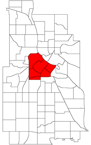
Central is a defined community in Minneapolis that consists of six smaller official neighborhoods around the downtown and central business core. It also includes the many old flour mills, the Mill District, and other historical and industrial areas of downtown Minneapolis. It also includes some high-density residential areas surrounding it, excluding areas east of the Mississippi River. Businesses and government buildings are based in the Central area include the corporate headquarters of the Star Tribune, Target, US Bancorp, the Hennepin County Government Center, Minneapolis Central Library, Minneapolis City Hall, and the broadcast facilities of the Minnesota CBS station WCCO-TV.
Kenwood is a neighborhood within the Calhoun-Isles community in Minneapolis along Lake of the Isles and Cedar Lake. The neighborhood is one of the most affluent in the city along with the nearby Lowry Hill neighborhood. The Kenwood neighborhood's most notable feature is the many historic mansions along the parkways overlooking the lake and the downtown skyline.

Bryn Mawr is a neighborhood within the Calhoun-Isles community in Minneapolis located directly west of downtown Minneapolis. It is in Ward 7, represented by council member Katie Cashman.

Cedar-Isles-Dean is a neighborhood in the Calhoun-Isles community in Minneapolis. Its boundaries are the Kenilworth Lagoon and Lake of the Isles to the north and east, West Lake Street to the south, and France Avenue South to the west. It is in Ward 7, represented by council member Katie Cashman.

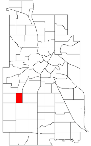
Linden Hills is a neighborhood in the Southwest community of Minneapolis on a hill overlooking Lake Harriet. It was one of the last areas to be developed in the City of Minneapolis. It is bordered to the north by Bde Maka Ska and West 36th Street, to the east by Lake Harriet and William Berry Parkway, to the south by West 47th Street, and to the west by France Avenue. Southwest High School is located at the southern edge of the neighborhood on West 47th Street between Abbott and Chowen Avenues.

King Field is a neighborhood in the Southwest community in Minneapolis, Minnesota. Its boundaries are 36th Street to the north, Interstate 35W to the east, 46th Street to the south, and Lyndale Avenue to the west. King Field, within the King Field neighborhood is a park named after Martin Luther King Jr.
The Bde Maka Ska Public Art Project is part of the Minneapolis Park and Recreation Board's Bde Maka Ska–Harriet Master Plan. In parallel with the restoring the name of Lake Calhoun to its Dakota name, Bde Maka Ska, a public art project was initiated to commemorate Ḣeyata Oṭuŋwe, a 19th-century Dakota agricultural community on the southeast bank of Bde Maka Ska, and its founder, Dakota leader Maḣpiya Wic̣aṡṭa.