Related Research Articles

Whittier is a neighborhood within the Powderhorn community in the U.S. city of Minneapolis, Minnesota, bounded by Franklin Avenue on the north, Interstate 35W on the east, Lake Street on the south, and Lyndale Avenue on the west. It is known for its many diverse restaurants, coffee shops and Asian markets, especially along Nicollet Avenue. The neighborhood is home to the Minneapolis Institute of Art, the Minneapolis College of Art and Design, and the Children's Theatre Company.

Uptown is a commercial district in southwestern Minneapolis in the U.S. state of Minnesota, that is centered at the intersection of Hennepin Avenue and West Lake Street. It has traditionally spanned the corners of four neighborhoods, Lowry Hill East, East Bde Maka Ska, South Uptown and East Isles neighborhoods, which are all within the Calhoun Isles community. Historically, the boundaries of Uptown are Bde Maka Ska to the west, Dupont Avenue to the east, 31st Street to the south, and 28th Street to the north; though these borders often vary. Uptown is a popular destination for retail, nightlife, and cultural events, and the district was famously written about by recording artist Prince.

Minneapolis is officially defined by its city council as divided into 83 neighborhoods. The neighborhoods are historically grouped into 11 communities. Informally, there are city areas with colloquial labels. Residents may also group themselves by their city street suffixes: North, Northeast, South, and Southeast.

Lowry Hill East, also known as the Wedge because of its wedge-like shape, is a neighborhood in southwest Minneapolis, Minnesota, United States, part of the Calhoun Isles community. It is bounded on the east by Lyndale Avenue, on the west by Hennepin Avenue and on the south by Lake Street. Lyndale and Hennepin intersect on the northern side at Interstate 94. This creates a neighborhood roughly triangular in shape.
The Southwest Journal was an American, English language free community paper covering 21 neighborhoods in Southwest Minneapolis. It was family owned and was founded in 1990. It covered the following neighborhoods:

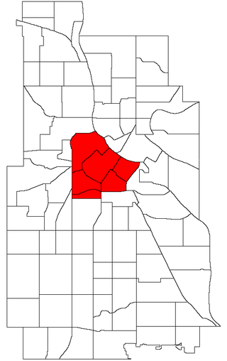
Calhoun-Isles is one of the official communities in the U.S. city of Minneapolis. It is split between Ward 7 and Ward 10 of the Minneapolis City Council, represented by councilmembers Katie Cashman and Aisha Chughtai, respectively.
East Bde Maka Ska is a neighborhood within the Calhoun-Isles community in the U.S. city of Minneapolis. It was known as East Calhoun prior to August 2021.

South Uptown is a residential neighborhood in the Calhoun Isles community of Minneapolis, Minnesota.

Lake Street is a major east-west thoroughfare between 29th and 31st streets in Minneapolis, Minnesota United States. From its western most end at the city's limits, Lake Street reaches the Chain of Lakes, passing over a small channel linking Bde Maka Ska and Lake of the Isles, and at its eastern most end it reaches the Mississippi River. In May 2020, the Lake Street corridor suffered extensive damage during local unrest following the murder of George Floyd. In August of the same year, city officials designated East Lake Street as one of seven cultural districts to promote racial equity, preserve cultural identity, and promote economic growth.

Loring Park is a neighborhood in the Central Community of Minneapolis, Minnesota. Located on the southwest corner of downtown Minneapolis, it also lends its name to Loring Park, the largest park in the neighborhood. The official boundaries of the neighborhood are Lyndale Avenue to the west, Interstate 394 to the north, 12th Street to the northeast, Highway 65 to the east, and Interstate 94 to the south. It is located in Minneapolis City Council Ward 7, represented by Katie Cashman.
Central is a defined community in Minneapolis that consists of six smaller official neighborhoods around the downtown and central business core. It also includes the many old flour mills, the Mill District, and other historical and industrial areas of downtown Minneapolis. It also includes some high-density residential areas surrounding it, excluding areas east of the Mississippi River. Businesses and government buildings are based in the Central area include the corporate headquarters of the Star Tribune, Target, US Bancorp, the Hennepin County Government Center, Minneapolis Central Library, Minneapolis City Hall, and the broadcast facilities of the Minnesota CBS station WCCO-TV.

Longfellow, also referred to as Greater Longfellow is a defined community in Minneapolis, Minnesota which includes five smaller neighborhoods inside of it: Seward, Cooper, Hiawatha, Howe and Longfellow. The community is a mix of agri-industrial properties along the old Northern Pacific Railway, expansive parkland surrounding the famous Minnehaha Falls, and smaller residential areas.

Cedar-Isles-Dean is a neighborhood in the Calhoun-Isles community in Minneapolis. Its boundaries are the Kenilworth Lagoon and Lake of the Isles to the north and east, West Lake Street to the south, and France Avenue South to the west. It is in Ward 7, represented by council member Katie Cashman.

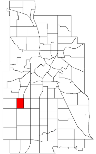
King Field is a neighborhood in the Southwest community in Minneapolis, Minnesota. Its boundaries are 36th Street to the north, Interstate 35W to the east, 46th Street to the south, and Lyndale Avenue to the west. King Field, within the King Field neighborhood is a park named after Martin Luther King Jr.

Corcoran is a neighborhood within the Powderhorn community in Minneapolis, Minnesota, United States. The neighborhood is bordered by Longfellow and Howe neighborhoods to the east, Phillips to the north, Powderhorn Park to the west and Standish to the south. Its official boundaries are East Lake Street to the north, Hiawatha Avenue to the east, East 36th Street to the south, and Cedar Avenue to the west. It is entirely located within Minneapolis City Council Ward 9, represented by Jason Chavez.
The Minneapolis Park and Recreation Board (MPRB) is an independent park district that owns, maintains, and programs activities in public parks in Minneapolis, Minnesota, United States. It has 500 full-time and 1,300 part-time employees and an $111 million operating and capital budget.

Minneapolis is often considered one of the top biking and walking cities in the United States due to its vast network of trails and dedicated pedestrian areas. In 2020, Walk Score rated Minneapolis as 13th highest among cities over 200,000 people. Some bicycling ratings list Minneapolis at the top of all United States cities, while others list Minneapolis in the top ten. There are over 80 miles (130 km) of paved, protected pathways in Minneapolis for use as transportation and recreation. The city's Grand Rounds National Scenic Byway parkway system accounts for the vast majority of the city's shared-use paths at approximately 50 miles (80 km) of dedicated biking and walking areas. By 2008, other city, county, and park board areas accounted for approximately 30 miles (48 km) of additional trails, for a city-wide total of approximately 80 miles (130 km) of protected pathways. The network of shared biking and walking paths continued to grow into the late 2010s with the additions of the Hiawatha LRT Trail gap remediation, Min Hi Line pilot projects, and Samatar Crossing. The city also features several natural-surface hiking trails, mountain-biking paths, groomed cross-country ski trails in winter, and other pedestrian walkways.
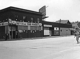
38th Street is a major east-west roadway in the U.S. city of Minneapolis and an officially designated cultural district in the Powderhorn community. The area developed into a residential zone when the Chicago Avenue street car line was extended to East 38th Street in 1880. Since the 1930s, the area has featured many Black-owned businesses, and the surrounding neighborhoods have had distinct histories from other neighborhoods in Minneapolis due to racial settlement patterns that concentrated Black residents there.

The 2023 Minneapolis City Council election took place in the city of Minneapolis, Minnesota, United States on November 7, 2023. The Minneapolis City Council is made up of 13 members serving four-year terms, with one council member representing each of the city's 13 wards. The 2023 election was the first election since the city's form of government moved to an Executive Mayor-Legislative Council structure. The change was prompted after voters narrowly approved a ballot measure in 2021 to shift certain powers from the city council to the mayor. Topics surrounding public safety, affordable housing, rent control, and racial justice were at the forefront of the campaign.
References
- ↑ "Map of Minneapolis neighborhoods". MNopedia. 1975. Retrieved May 2, 2024.
- ↑ "Minneapolis-Saint Paul Neighborhoods". MN Compass. 2024. Retrieved May 2, 2024.
- ↑ "City of Minneapolis Neighborhoods & Communities". Minneapolis 411. July 3, 2008.
- ↑ "Community and neighborhoods". Minneapolismn.gov. December 12, 2023. Retrieved May 2, 2024.
- ↑ Benishek, Mark (June 7, 2019). "Neighborhoods". Opendata.minneapolismn.gov. Retrieved May 2, 2024.