The Diamond Lake neighborhood is in the Nokomis community in Minneapolis. It is bounded by Diamond Lake Road and 55th Street on the north, Cedar Avenue on the east, 62nd Street on the south, and Interstate 35W on the west. It is a part of Ward 11, currently represented by city council member Emily Koski.

South Uptown is a residential neighborhood in the Calhoun Isles community of Minneapolis, Minnesota.

Hiawatha is a neighborhood within the larger Longfellow community in Minneapolis. It is bordered by 40th Street to the north, the Mississippi River to the east, 54th Street East to the south, and Hiawatha Avenue to the west. Its neighbors are Howe to the north, the Mississippi River to the east, Minnehaha Park and the Minnehaha neighborhood to the south, and Ericsson and Standish to the west.

Hale is a neighborhood near the southern edge of Minneapolis. It lies south of Minnehaha Creek, north of 55th Street, east of Chicago Avenue, and west of Cedar Avenue. It is a part of Ward 11, currently represented by city council member Emily Koski.

Field is a neighborhood in the Nokomis community in south Minneapolis, Minnesota. The neighborhood is bordered by East 46th Street on the north, Chicago Avenue on the east, Minnehaha Parkway on the south, and Interstate 35W on the west. Field shares a neighborhood organization with the Regina and Northrop neighborhoods, called the Field Regina Northrop Neighborhood Group (FRNNG).

Bancroft is a neighborhood within the Powderhorn community in Minneapolis, Minnesota, United States. Its boundaries are East 38th Street to the north, Chicago Avenue to the west, East 42nd Street to the south and Cedar Avenue to the east. It is entirely located within Minneapolis City Council Ward 8, represented by Andrea Jenkins.

Nokomis is a defined community in Minneapolis, Minnesota. It takes its name from Lake Nokomis. It comprises eleven smaller neighborhoods. Nokomis neighborhoods fall in Minneapolis City Council wards 8, 11, and 12, currently represented by council members Andrea Jenkins, Emily Koski, and Aurin Chowdhury, respectively.

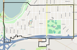
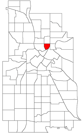
Downtown West is an official neighborhood in Minneapolis, part of the larger Central community. It is the heart of downtown Minneapolis, containing the bulk of high-rise office buildings in the city, and is what comes to mind when most Minneapolitans think of "downtown". The neighborhood is split between Wards 3 and 7 of the Minneapolis City Council, represented by Michael Rainville and Katie Cashman, respectively.
Standish is a neighborhood within the Powderhorn community in Minneapolis, Minnesota, United States named after Captain Miles Standish. Its boundaries are East 36th Street to the north, Hiawatha Avenue to the east, East 42nd and 43rd Streets to the south, and Cedar Avenue to the west.

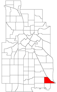
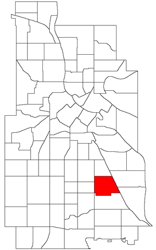
Ericsson is a neighborhood within the Nokomis community in Minneapolis. Its boundaries are East 42nd and 43rd Streets to the north, Hiawatha Avenue to the east, Minnehaha Parkway to the south, and Cedar Avenue to the west.
East Harriet is a neighborhood in the Southwest community in Minneapolis. Its boundaries are West 36th Street to the north, Lyndale Avenue South to the east, West 46th Street to the south, and Lake Harriet, Lakewood Cemetery, and William Berry Parkway to the west.

Page is a neighborhood in the Nokomis community in Minneapolis. Its boundaries are the Minnehaha Creek to the north, Chicago Avenue to the east, Diamond Lake Road and East 55th Street to the south, and Interstate 35W to the west. It is located within Ward 11, currently represented by city council member Emily Koski.

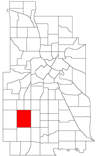
Regina is a neighborhood within the Nokomis community in Minneapolis, Minnesota. Its boundaries are 42nd Street to the north, Chicago Avenue to the east, 46th Street to the south, and Interstate 35W to the west.
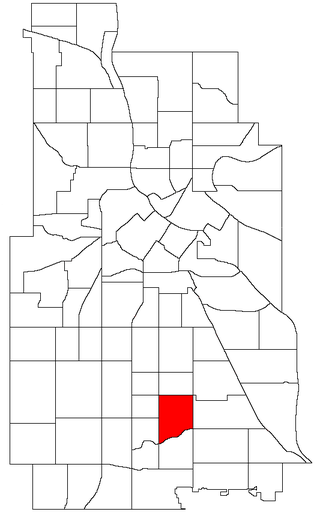
Northrop is a neighborhood located in the Nokomis community in Minneapolis, Minnesota, United States. The neighborhood is bordered by 42nd Street to the north, Cedar Avenue to the east, Minnehaha Parkway to the south, and Chicago Avenue to the west.

Keewaydin is a neighborhood in the Nokomis community in Minneapolis, Minnesota. Its boundaries are Minnehaha Parkway to the north, 34th Avenue to the east, 54th Street to the south, and Cedar Avenue to the west.

Morris Park is a neighborhood in the Nokomis community in Minneapolis, Minnesota. Its boundaries are 54th Street to the north, 46th Avenue to the east, the Twin Cities Air Force Base to the south, and 34th Avenue to the west. It is located in Ward 12 of the Minneapolis City Council, currently represented by council member Aurin Chowdhury.
Wenonah is a neighborhood on the southeast side of Minneapolis, Minnesota. Its boundaries are 54th Street to the north, 34th Avenue to the east, the Minneapolis-Saint Paul International Airport to the south, and Cedar Avenue to the west. The neighborhood contains a portion of Lake Nokomis.

Lynnhurst is a neighborhood in the Southwest community in Minneapolis, Minnesota. Its boundaries are 46th Street to the north, Lyndale Avenue to the east, 54th Street to the south, and Penn Avenue to the west. It is located along the southeastern shore of Lake Harriet. Outflows from the lake run through a parkway for several city blocks to reach Minnehaha Creek.
St. Anthony East is a neighborhood of the Northeast community in Minneapolis. It is located in Ward 3, currently represented by council member Michael Rainville.

Nokomis East is a group of neighborhoods in the southeastern corner of Minneapolis, Minnesota, United States. It consists of four neighborhoods: Keewaydin, Minnehaha, Morris Park and Wenonah. Nokomis East contains two schools, the Nokomis Community Library, and a post office. On its western edge is Lake Nokomis, for which it is named. Two regional parks, and three neighborhood parks, provide recreation and educational programming for all age groups. Seven churches serve residents of various denominations. Nokomis East is served by the Nokomis East Neighborhood Association (NENA). The main transportation corridors are the neighborhood boundaries: Cedar Avenue, 34th and 28th Avenues, 50th and 54th Streets, Hwy 55, and Crosstown highway 62.