Lauter, Bavaria

Last updated
Lauter
Lauter church P2RM0003.jpg
Church of Saint Lawrence
DEU Lauter COA.svg
Coat of arms
Location of Lauter within Bamberg district
Lauter in BA.svg
Germany adm location map.svg
Red pog.svg
Lauter
Bavaria location map.svg
Red pog.svg
Lauter
Coordinates: 49°58′N10°47′E / 49.967°N 10.783°E / 49.967; 10.783 Coordinates: 49°58′N10°47′E / 49.967°N 10.783°E / 49.967; 10.783
Country Germany
State Bavaria
Admin. region Oberfranken
District Bamberg
Municipal assoc. Baunach
Government
   Mayor Armin Postler (CSU)
Area
  Total12.76 km2 (4.93 sq mi)
Elevation
269 m (883 ft)
Population
 (2018-12-31) [1]
  Total1,148
  Density90/km2 (230/sq mi)
Time zone CET/CEST (UTC+1/+2)
Postal codes
96169
Dialling codes 09544
Vehicle registration BA
Website Official website

Lauter is a community in the Upper Franconian district of Bamberg and a member of the administrative community (Verwaltungsgemeinschaft) of Baunach.

Upper Franconia Regierungsbezirk in Bavaria, Germany

Upper Franconia is a Regierungsbezirk of the state of Bavaria, southern Germany. It forms part of the historically significant region of Franconia, all now part of the German Federal State of Bayern (Bavaria).

Bamberg is a Landkreis (district) in Bavaria, Germany. It surrounds but does not include the town of Bamberg. The district is bounded by the districts of Lichtenfels, Bayreuth, Forchheim, Erlangen-Höchstadt, Neustadt (Aisch)-Bad Windsheim, Kitzingen, Schweinfurt and Haßberge.

Contents

Geography

The community lies in the Upper Franconia-West region on the Bach Lauter (brook), which runs into the river Baunach.

Constituent communities

The community is made up of the centres of Lauter with 601 inhabitants, Deusdorf with 277, Appendorf with 213, Leppelsdorf with 85, Krappenhof with 8 and Deusdorfer Mühle with 7. (as of 2004/2005)

The community also has 4 traditional rural land units, known in German as Gemarkungen, named Deusdorf, Lauter, Leppelsdorf and Appendorf, the same names as 4 of the constituent communities (it is traditional for a Gemarkung to be named after a town or village lying nearby).

German language West Germanic language

German is a West Germanic language that is mainly spoken in Central Europe. It is the most widely spoken and official or co-official language in Germany, Austria, Switzerland, South Tyrol in Italy, the German-speaking Community of Belgium, and Liechtenstein. It is also one of the three official languages of Luxembourg and a co-official language in the Opole Voivodeship in Poland. The languages which are most similar to German are the other members of the West Germanic language branch: Afrikaans, Dutch, English, the Frisian languages, Low German/Low Saxon, Luxembourgish, and Yiddish. There are also strong similarities in vocabulary with Danish, Norwegian and Swedish, although those belong to the North Germanic group. German is the second most widely spoken Germanic language, after English.

History

Pope Innocent IV stated in 1251 in a document the goods and privileges of the Michelsberg Monastery in Lauter. Lauter belonged to the High Monastery at Bamberg. The Counts of Truhendingen had their seat at the Stiefenburg (castle) near Lauter. Since the Reichsdeputationshauptschluss of 1803, the community has belonged to Bavaria. In the course of administrative reform in Bavaria, today’s community came into being under the Gemeindeedikt (“Community Edict”) of 1818.

Monastery complex of buildings comprising the domestic quarters and workplace(s) of monks or nuns

A monastery is a building or complex of buildings comprising the domestic quarters and workplaces of monastics, monks or nuns, whether living in communities or alone (hermits). A monastery generally includes a place reserved for prayer which may be a chapel, church, or temple, and may also serve as an oratory, or in the case of communities anything from a single building housing only one senior and two or three junior monks or nuns, to vast complexes and estates housing tens or hundreds. A monastery complex typically comprises a number of buildings which include a church, dormitory, cloister, refectory, library, balneary and infirmary. Depending on the location, the monastic order and the occupation of its inhabitants, the complex may also include a wide range of buildings that facilitate self-sufficiency and service to the community. These may include a hospice, a school, and a range of agricultural and manufacturing buildings such as a barn, a forge, or a brewery.

<i lang="de" title="German language text">Reichsdeputationshauptschluss</i>

The Reichsdeputationshauptschluss, sometimes referred to in English as the Final Recess or the Imperial Recess of 1803, was a resolution passed by the Reichstag of the Holy Roman Empire on 24 March 1803. It was ratified by the Emperor Francis II and became law on 27 April. It proved to be the last significant law enacted by the Empire before its dissolution in 1806.

Bavaria State in Germany

Bavaria, officially the Free State of Bavaria, is a landlocked federal state of Germany, occupying its southeastern corner. With an area of 70,550.19 square kilometres, Bavaria is the largest German state by land area comprising roughly a fifth of the total land area of Germany. With 13 million inhabitants, it is Germany's second-most-populous state after North Rhine-Westphalia. Bavaria's main cities are Munich, Nuremberg and Augsburg.

Population development

Within municipal limits, 1,000 inhabitants were counted in 1970, 1,024 in 1987 and 1,124 in 2000, In 2004 and 2005 it was 1,191.

Politics

The mayor is Armin Postler (CSU). He succeeded Manfred Beierlieb (Freie Wähler) in 2002.

The community council is made up of 12 members, listed here by party or voter community affiliation, and also with the number of seats that each holds:

In 1999, municipal tax revenue, converted to euros, amounted to €497,000 of which business taxes (net) amounted to €126,000.

Euro European currency

The euro is the official currency of 19 of the 28 member states of the European Union. This group of states is known as the eurozone or euro area, and counts about 343 million citizens as of 2019. The euro is the second-largest and second-most traded currency in the foreign exchange market after the United States dollar, and is divided into 100 cents.

Coat of arms

Lauter’s arms might heraldically be described thus: Gules two wings argent emerging from each inwards a clothed arm argent, each of which holds the handle of a grill reversed Or.

Economy and infrastructure

According to official statistics, there were no workers on the social welfare contribution rolls working in producing businesses in 1998, and in trade and transport also none, but 391 such workers worked from home. In processing businesses there were two businesses, and in construction 3. Furthermore, in 1999, there were 32 agricultural operations with a working area of 315 ha, of which 247 ha was cropland and 67 ha was meadowland.

Transport Human-directed movement of things or people between locations

Transport or transportation is the movement of humans, animals and goods from one location to another. In other words, the action of transport is defined as a particular movement of an organism or thing from a point A to a Point B. Modes of transport include air, land, water, cable, pipeline and space. The field can be divided into infrastructure, vehicles and operations. Transport enables trade between people, which is essential for the development of civilizations.

Education

In 1999, the following institutions existed in Lauter:

Other meaning

Lauter is also a German word that means “louder” or “more loudly”.

Related Research Articles

Stegaurach Place in Bavaria, Germany

Stegaurach is a community in the Upper Franconian district of Bamberg and the seat of the administrative community (Verwaltungsgemeinschaft) of Stegaurach.

Wattendorf Place in Bavaria, Germany

Wattendorf is the smallest community in the Upper Franconian district of Bamberg and a member of the administrative community (Verwaltungsgemeinschaft) of Steinfeld.

Kleinwallstadt Place in Bavaria, Germany

Kleinwallstadt is a market community in the Miltenberg district in the Regierungsbezirk of Lower Franconia (Unterfranken) in Bavaria, Germany and the seat of the like-named Verwaltungsgemeinschaft.

Altendorf, Upper Franconia Place in Bavaria, Germany

Altendorf is a community in the Upper Franconian district of Bamberg, Bavaria, Germany.

Burgwindheim Place in Bavaria, Germany

Burgwindheim is a municipality with market rights in the west of the Upper Franconian district of Bamberg and a member of the administrative community (Verwaltungsgemeinschaft) of Ebrach.

Ebrach Place in Bavaria, Germany

Ebrach is a community with market rights in the Upper Franconian district of Bamberg and the seat of the Verwaltungsgemeinschaft of Ebrach.

Frensdorf Place in Bavaria, Germany

Frensdorf is a community in the Upper Franconian district of Bamberg.

Gerach Place in Bavaria, Germany

Gerach is a community in the Upper Franconian district of Bamberg and a member of the administrative community (Verwaltungsgemeinschaft) of Baunach. It lies in the Naturpark Haßberge roughly 20 km north of Bamberg and roughly 10 km south of Ebern.

Gundelsheim, Bavaria Place in Bavaria, Germany

Gundelsheim is a community in the Upper Franconian district of Bamberg.

Oberhaid Place in Bavaria, Germany

Oberhaid is a community in the Upper Franconian district of Bamberg.

Priesendorf Place in Bavaria, Germany

Priesendorf is a community in the Upper Franconian district of Bamberg and a member of the administrative community (Verwaltungsgemeinschaft) of Lisberg.

Rattelsdorf Place in Bavaria, Germany

Rattelsdorf is a community with market rights in the Upper Franconian district of Bamberg.

Schönbrunn im Steigerwald Place in Bavaria, Germany

Schönbrunn im Steigerwald is a community in the Upper Franconian district of Bamberg and a member of the administrative community (Verwaltungsgemeinschaft) of Burgebrach.

Stadelhofen Place in Bavaria, Germany

Stadelhofen is a municipality in the Upper Franconian district of Bamberg and a member of the administrative community (Verwaltungsgemeinschaft) of Steinfeld.

Strullendorf Place in Bavaria, Germany

Strullendorf is a community in the Upper Franconian district of Bamberg.

Hafenlohr Place in Bavaria, Germany

Hafenlohr is a community in the Main-Spessart district in the Regierungsbezirk of Lower Franconia (Unterfranken) in Bavaria, Germany and a member of the Verwaltungsgemeinschaft of Marktheidenfeld.

Karbach, Bavaria Place in Bavaria, Germany

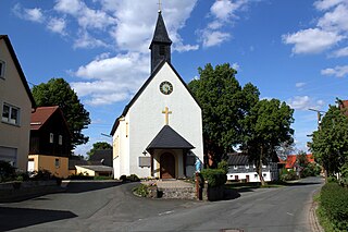
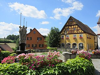
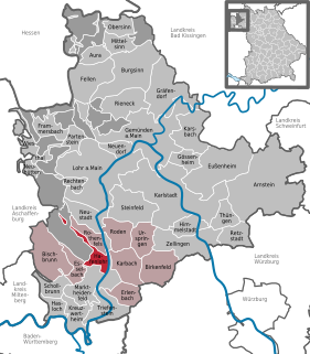
Karbach is a market community in the Main-Spessart district in the Regierungsbezirk of Lower Franconia (Unterfranken) in Bavaria, Germany and a member of the Verwaltungsgemeinschaft of Marktheidenfeld.

Rechtenbach Place in Bavaria, Germany

Rechtenbach is a community in the Main-Spessart district in the Regierungsbezirk of Lower Franconia (Unterfranken) in Bavaria, Germany and a member of the Verwaltungsgemeinschaft of Lohr am Main. It has a population of around 1,000.

Retzstadt Place in Bavaria, Germany

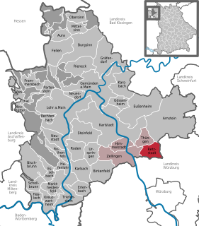
Retzstadt is a community in the Main-Spessart district in the Regierungsbezirk of Lower Franconia (Unterfranken) in Bavaria, Germany and a member of the Verwaltungsgemeinschaft of Zellingen.

Schneeberg, Bavaria Place in Bavaria, Germany

Schneeberg is a market municipality in the Miltenberg district in the Regierungsbezirk of Lower Franconia (Unterfranken) in Bavaria, Germany.

References

  1. "Fortschreibung des Bevölkerungsstandes". Bayerisches Landesamt für Statistik und Datenverarbeitung (in German). July 2019.