Lisberg | |
|---|---|
 | |
 Coat of arms | |
Location of Lisberg within Bamberg district  | |
 Location of Lisberg | |
 Lisberg  Lisberg | |
| Coordinates: 49°52′03″N10°47′22″E / 49.86750°N 10.78944°E | |
| Country | Germany |
| State | Bavaria |
| Admin. region | Oberfranken |
| District | Bamberg |
| Municipal assoc. | Lisberg |
| Subdivisions | 4 Ortsteile |
| Government | |
| • Mayor (2020–26) | Michael Bergrab [1] |
| Area | |
• Total | 8.36 km2 (3.23 sq mi) |
| Highest elevation | 384 m (1,260 ft) |
| Lowest elevation | 288 m (945 ft) |
| Population (2023-12-31) [2] | |
• Total | 1,708 |
| • Density | 204/km2 (529/sq mi) |
| Time zone | UTC+01:00 (CET) |
| • Summer (DST) | UTC+02:00 (CEST) |
| Postal codes | 96170 |
| Dialling codes | 09549 |
| Vehicle registration | BA |
| Website | www.lisberg.de |
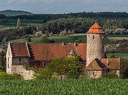
Lisberg is a municipality in Bavaria, Germany. It is in the Upper Franconian district of Bamberg and a member of the administrative community (Verwaltungsgemeinschaft) of Lisberg, lying in the Steigerwald (forest).
