Stegaurach

Last updated
Stegaurach
Stegaurach-07.JPG
Böttinger Manor
DEU Stegaurach COA.svg
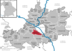
Location of Stegaurach within Bamberg district
Stegaurach in BA.svgZückshuter ForstWinkelhofer ForstSteinachsrangenSembergLindach (unincorporated area)Koppenwinder ForstHauptsmoorwaldGeisberger ForstEichwald (unincorporated area)Ebracher ForstEbracher ForstWalsdorfLauterGundelsheimKönigsfeldAltendorf
Germany adm location map.svg
Red pog.svg
Stegaurach
Bavaria location map.svg
Red pog.svg
Stegaurach
Coordinates: 49°52′12″N10°46′56″E / 49.87000°N 10.78222°E / 49.87000; 10.78222 Coordinates: 49°52′12″N10°46′56″E / 49.87000°N 10.78222°E / 49.87000; 10.78222
Country Germany
State Bavaria
Admin. region Oberfranken
District Bamberg
Municipal assoc. Stegaurach
Subdivisions11 Ortsteile
Government
   Mayor (202026) Thilo Wagner [1] (FW)
Area
  Total23.89 km2 (9.22 sq mi)
Elevation
268 m (879 ft)
Population
 (2021-12-31) [2]
  Total7,075
  Density300/km2 (770/sq mi)
Time zone UTC+01:00 (CET)
  Summer (DST) UTC+02:00 (CEST)
Postal codes
96135
Dialling codes 0951
Vehicle registration BA
Website www.stegaurach.de

Stegaurach is a community and a village in the Upper Franconian district of Bamberg and the seat of the administrative community (Verwaltungsgemeinschaft) of Stegaurach.

Contents

Geography

The community lies in the valley of the Aurach, about 4 km west of Bamberg. Stegaurach lies in the Upper Franconia-West region.

Constituent communities

Stegaurach’s main and namesake centre is by far the biggest of its Ortsteile with a population of 4,033. The community furthermore has these outlying centres, each given here with its own population figure and dialectal name where there is one:

The village Stegaurach is known in the local speech as “Aurich”.

The community also has 5 traditional rural land units, known in German as Gemarkungen, named Hartlanden, Höfen, Mühlendorf, Stegaurach and Birkacher Wald, four of which (all but the last, which is a woodland) have the same names as four of the constituent communities (it is traditional for a Gemarkung to be named after a town or village lying nearby).

History

Stegaurach belonged to the High Monastery at Bamberg. Stegaurach was actually part of the hereditary estate administration, a great deal of which was nevertheless made up of the High Monastery’s property or its Mediaten. Since the Reichsdeputationshauptschluss of 1803, the community has belonged to Bavaria.

Population development

Within municipal limits, 3,935 inhabitants were counted in 1970, 4,958 in 1987 and 6,382 in 2000. In 2005 it was 6,747. In the next year the population figure climbed sharply, giving Stegaurach a population of 6,841 on 31 December 2006.

Politics

The mayor is Thilo Wagner (Free Voters), first elected in 2014 and re-elected in 2020.

The community council is made up of 20 members, listed here by party or voter community affiliation, and also with the number of seats that each holds:

In 1999, municipal tax revenue, converted to euros, amounted to €2,573,000 of which business taxes (net) amounted to €263,000.

Economy and infrastructure

According to official statistics, there were no workers on the social welfare contribution rolls working in producing businesses or trade and transport. In other areas, 313 workers on the social welfare contribution rolls were employed, and 2,120 such workers worked from home. In processing businesses there were three businesses, and in construction 7. Furthermore, in 1999, there were 46 agricultural operations with a working area of 795 ha, of which 571 ha was cropland and 223 ha was meadowland.

Education

In 1999, the following institutions existed in Stegaurach:

Town twinning

Related Research Articles

<span class="mw-page-title-main">Wattendorf</span> Municipality in Bavaria, Germany

Wattendorf is the smallest community in the Upper Franconian district of Bamberg and a member of the administrative community (Verwaltungsgemeinschaft) of Steinfeld.

<span class="mw-page-title-main">Hallstadt</span> Town in Bavaria, Germany

Hallstadt is a town in the Upper Franconian district of Bamberg on the left bank of the Main, 4 km north of Bamberg.

<span class="mw-page-title-main">Heinrichsthal</span> Municipality in Bavaria, Germany

Heinrichsthal is a community in the Aschaffenburg district in the Regierungsbezirk of Lower Franconia (Unterfranken) in Bavaria, Germany. It is part of the Verwaltungsgemeinschaft of Heigenbrücken.

<span class="mw-page-title-main">Altendorf, Upper Franconia</span> Municipality in Bavaria, Germany

Altendorf is a community in the Upper Franconian district of Bamberg, Bavaria, Germany.

<span class="mw-page-title-main">Burgwindheim</span> Municipality in Bavaria, Germany

Burgwindheim is a municipality with market rights in the west of the Upper Franconian district of Bamberg and a member of the administrative community (Verwaltungsgemeinschaft) of Ebrach.

<span class="mw-page-title-main">Ebrach</span> Municipality in Bavaria, Germany

Ebrach is a municipality with market rights in the Upper Franconian district of Bamberg and the seat of the Verwaltungsgemeinschaft of Ebrach.

<span class="mw-page-title-main">Frensdorf</span> Municipality in Bavaria, Germany

Frensdorf is a community in the Upper Franconian district of Bamberg.

<span class="mw-page-title-main">Gundelsheim, Bavaria</span> Municipality in Bavaria, Germany

Gundelsheim is a community in the Upper Franconian district of Bamberg.

<span class="mw-page-title-main">Kemmern</span> Municipality in Bavaria, Germany

Kemmern is a community in the Upper Franconian district of Bamberg in Bavaria, southern Germany.

<span class="mw-page-title-main">Lauter, Bavaria</span> Municipality in Bavaria, Germany

Lauter is a community in the Upper Franconian district of Bamberg and a member of the administrative community (Verwaltungsgemeinschaft) of Baunach.

<span class="mw-page-title-main">Priesendorf</span> Municipality in Bavaria, Germany

Priesendorf is a community in the Upper Franconian district of Bamberg and a member of the administrative community (Verwaltungsgemeinschaft) of Lisberg.

<span class="mw-page-title-main">Rattelsdorf</span> Municipality in Bavaria, Germany

Rattelsdorf is a municipality with market rights in the Upper Franconian district of Bamberg.

<span class="mw-page-title-main">Schönbrunn im Steigerwald</span> Municipality in Bavaria, Germany

Schönbrunn im Steigerwald is a community in the Upper Franconian district of Bamberg and a member of the administrative community (Verwaltungsgemeinschaft) of Burgebrach.

<span class="mw-page-title-main">Stadelhofen</span> Municipality in Bavaria, Germany

Stadelhofen is a municipality in the Upper Franconian district of Bamberg and a member of the administrative community (Verwaltungsgemeinschaft) of Steinfeld.

<span class="mw-page-title-main">Strullendorf</span> Municipality in Bavaria, Germany

Strullendorf is a community in the Upper Franconian district of Bamberg.

<span class="mw-page-title-main">Viereth-Trunstadt</span> Municipality in Bavaria, Germany

Viereth-Trunstadt is a community in the Upper Franconian district of Bamberg lying on the Main.

<span class="mw-page-title-main">Walsdorf, Bavaria</span> Municipality in Bavaria, Germany

Walsdorf is a community in the Upper Franconian district of Bamberg and a member of the administrative community (Verwaltungsgemeinschaft) of Stegaurach. It lies in the valley of the Aurach roughly ten kilometres west of Bamberg.

<span class="mw-page-title-main">Eußenheim</span> Municipality in Bavaria, Germany

Eußenheim is a community in the Main-Spessart district in the Regierungsbezirk of Lower Franconia (Unterfranken) in Bavaria, Germany.

<span class="mw-page-title-main">Schollbrunn</span> Municipality in Bavaria, Germany

Schollbrunn is a community in the Main-Spessart district in the Regierungsbezirk of Lower Franconia (Unterfranken) in Bavaria, Germany and a member of the Verwaltungsgemeinschaft of Kreuzwertheim. It has a population of over 900.

<span class="mw-page-title-main">Faulbach</span> Municipality in Bavaria, Germany

Faulbach is a municipality in the Miltenberg district in the Regierungsbezirk of Lower Franconia (Unterfranken) in Bavaria, Germany. It has a population of around 2,600.

References

  1. Liste der ersten Bürgermeister/Oberbürgermeister in kreisangehörigen Gemeinden, Bayerisches Landesamt für Statistik, 15 July 2021.
  2. "Tabelle 12411-003r Fortschreibung des Bevölkerungsstandes: Gemeinden, Stichtag" (in German). Bayerisches Landesamt für Statistik. June 2022.