Priesendorf

Last updated
Priesendorf
Hauptstrasse 20 Priesendorf 20180328 001.jpg
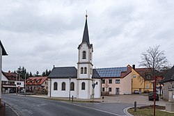
Chapel of Virgin Mary on the main street
DEU Priesendorf COA.svg
Location of Priesendorf within Bamberg district
Priesendorf in BA.svgZückshuter ForstWinkelhofer ForstSteinachsrangenSembergLindach (unincorporated area)Koppenwinder ForstHauptsmoorwaldGeisberger ForstEichwald (unincorporated area)Ebracher ForstEbracher ForstWalsdorfLauterGundelsheimKönigsfeldAltendorf
Germany adm location map.svg
Red pog.svg
Priesendorf
Bavaria location map.svg
Red pog.svg
Priesendorf
Coordinates: 49°54′N10°42′E / 49.900°N 10.700°E / 49.900; 10.700 Coordinates: 49°54′N10°42′E / 49.900°N 10.700°E / 49.900; 10.700
Country Germany
State Bavaria
Admin. region Oberfranken
District Bamberg
Municipal assoc. Lisberg
Subdivisions2 Ortsteile
Government
   Mayor (202026) Matthias Krapp [1] (CSU)
Area
  Total8.35 km2 (3.22 sq mi)
Elevation
297 m (974 ft)
Population
 (2021-12-31) [2]
  Total1,517
  Density180/km2 (470/sq mi)
Time zone UTC+01:00 (CET)
  Summer (DST) UTC+02:00 (CEST)
Postal codes
96170
Dialling codes 09549
Vehicle registration BA
Website Official website

Priesendorf is a community in the Upper Franconian district of Bamberg and a member of the administrative community (Verwaltungsgemeinschaft) of Lisberg.

Contents

Geography

The community lies in the Steigerwald (forest) on the small river Aurach on the boundary between Upper and Lower Franconia.

Constituent communities

Priesendorf's main and namesake centre is by far the bigger of its Gemeindeteile with a population of 1,237. The community furthermore has the outlying centre of Neuhausen with a population of 264.

The community also has two traditional rural land units, known in German as Gemarkungen, also named Priesendorf and Neuhausen (it is traditional for a Gemarkung to be named after a town or village lying nearby).

History

Priesendorf belonged to the Barons Münster at Lisberg and was part of the knightly estate of Lisberg. With the Act of the Confederation of the Rhine in 1806, the community passed to Bavaria.

Population development

Within municipal limits, 1,056 inhabitants were counted in 1970, 1,240 in 1987 and 1,456 in 2000. On 30 June 2007 it was 1,532.

Politics

The mayor is Matthias Krapp (CSU), elected in 2020.

The community council is made up of 12 members, listed here by party or voter community affiliation, and also with the number of seats that each holds:

In 1999, municipal tax revenue, converted to euros, amounted to €508,000 of which business taxes (net) amounted to €29,000.

Economy and infrastructure

According to official statistics, there were 26 workers on the social welfare contribution rolls working in agriculture or forestry in 1998, 184 in producing businesses, and in trade and transport 5. In other areas, 28 workers on the social welfare contribution rolls were employed, and 546 such workers worked from home. In processing businesses there were three businesses, and in construction two. Furthermore, in 1999, there were 29 agricultural operations with a working area of 406 ha, of which 282 ha was cropland and 99 ha was meadowland.

Education

In 1999, the following institutions existed in Priesendorf:

Related Research Articles

<span class="mw-page-title-main">Stegaurach</span> Municipality in Bavaria, Germany

Stegaurach is a community and a village in the Upper Franconian district of Bamberg and the seat of the administrative community (Verwaltungsgemeinschaft) of Stegaurach.

<span class="mw-page-title-main">Wattendorf</span> Municipality in Bavaria, Germany

Wattendorf is the smallest community in the Upper Franconian district of Bamberg and a member of the administrative community (Verwaltungsgemeinschaft) of Steinfeld.

<span class="mw-page-title-main">Heinrichsthal</span> Municipality in Bavaria, Germany

Heinrichsthal is a community in the Aschaffenburg district in the Regierungsbezirk of Lower Franconia (Unterfranken) in Bavaria, Germany. It is part of the Verwaltungsgemeinschaft of Heigenbrücken.

<span class="mw-page-title-main">Burgwindheim</span> Municipality in Bavaria, Germany

Burgwindheim is a municipality with market rights in the west of the Upper Franconian district of Bamberg and a member of the administrative community (Verwaltungsgemeinschaft) of Ebrach.

<span class="mw-page-title-main">Ebrach</span> Municipality in Bavaria, Germany

Ebrach is a municipality with market rights in the Upper Franconian district of Bamberg and the seat of the Verwaltungsgemeinschaft of Ebrach.

<span class="mw-page-title-main">Frensdorf</span> Municipality in Bavaria, Germany

Frensdorf is a community in the Upper Franconian district of Bamberg.

<span class="mw-page-title-main">Gundelsheim, Bavaria</span> Municipality in Bavaria, Germany

Gundelsheim is a community in the Upper Franconian district of Bamberg.

<span class="mw-page-title-main">Lauter, Bavaria</span> Municipality in Bavaria, Germany

Lauter is a community in the Upper Franconian district of Bamberg and a member of the administrative community (Verwaltungsgemeinschaft) of Baunach.

<span class="mw-page-title-main">Rattelsdorf</span> Municipality in Bavaria, Germany

Rattelsdorf is a municipality with market rights in the Upper Franconian district of Bamberg.

<span class="mw-page-title-main">Schönbrunn im Steigerwald</span> Municipality in Bavaria, Germany

Schönbrunn im Steigerwald is a community in the Upper Franconian district of Bamberg and a member of the administrative community (Verwaltungsgemeinschaft) of Burgebrach.

<span class="mw-page-title-main">Strullendorf</span> Municipality in Bavaria, Germany

Strullendorf is a community in the Upper Franconian district of Bamberg.

<span class="mw-page-title-main">Viereth-Trunstadt</span> Municipality in Bavaria, Germany

Viereth-Trunstadt is a community in the Upper Franconian district of Bamberg lying on the Main.

<span class="mw-page-title-main">Walsdorf, Bavaria</span> Municipality in Bavaria, Germany

Walsdorf is a community in the Upper Franconian district of Bamberg and a member of the administrative community (Verwaltungsgemeinschaft) of Stegaurach. It lies in the valley of the Aurach roughly ten kilometres west of Bamberg.

<span class="mw-page-title-main">Bruck, Upper Bavaria</span> Municipality in Bavaria, Germany

Bruck is a community in the Upper Bavarian district of Ebersberg. It is a member of the municipal association (Verwaltungsgemeinschaft) of Glonn.

<span class="mw-page-title-main">Birkenfeld, Bavaria</span> Municipality in Bavaria, Germany

Birkenfeld is a community in the Main-Spessart district in the Regierungsbezirk of Lower Franconia (Unterfranken) in Bavaria, Germany and a member of the Verwaltungsgemeinschaft of Marktheidenfeld.

<span class="mw-page-title-main">Hafenlohr</span> Municipality in Bavaria, Germany

Hafenlohr is a community in the Main-Spessart district in the Regierungsbezirk of Lower Franconia (Unterfranken) in Bavaria, Germany and a member of the Verwaltungsgemeinschaft of Marktheidenfeld.

<span class="mw-page-title-main">Karsbach</span> Municipality in Bavaria, Germany

Karsbach is a municipality in the Main-Spessart district in the Regierungsbezirk of Lower Franconia (Unterfranken) in Bavaria, Germany and a member of the Verwaltungsgemeinschaft of Gemünden am Main.

<span class="mw-page-title-main">Retzstadt</span> Municipality in Bavaria, Germany

Retzstadt is a community in the Main-Spessart district in the Regierungsbezirk of Lower Franconia (Unterfranken) in Bavaria, Germany and a member of the Verwaltungsgemeinschaft of Zellingen.

<span class="mw-page-title-main">Eschau</span> Municipality in Bavaria, Germany

Eschau is a market community in the Miltenberg district in the Regierungsbezirk of Lower Franconia (Unterfranken) in Bavaria, Germany. It has a population of around 3,800.

<span class="mw-page-title-main">Hausen, Miltenberg</span> Municipality in Bavaria, Germany

Hausen is a community in the Miltenberg district in the Regierungsbezirk of Lower Franconia (Unterfranken) in Bavaria, Germany and a member of the Verwaltungsgemeinschaft of Kleinwallstadt.

References

  1. Liste der ersten Bürgermeister/Oberbürgermeister in kreisangehörigen Gemeinden, Bayerisches Landesamt für Statistik, 15 July 2021.
  2. "Tabelle 12411-003r Fortschreibung des Bevölkerungsstandes: Gemeinden, Stichtag" (in German). Bayerisches Landesamt für Statistik. June 2022.