Levittown is 40 feet (12m) above sea level. Though not a municipality, it is sometimes recognized as the largest suburb of Philadelphia[5] while Upper Darby, Lower Merion, Bensalem, Abington, and Bristol townships are municipalities larger in size within the three surrounding Pennsylvania counties. Starting with land purchased in 1951, it was planned and built by Levitt & Sons. The brothers William Levitt and architect Alfred Levitt designed its six typical houses.
Levittown is located 72.5 miles (116.7km) southeast of Allentown and 26.6 miles (42.8km) northeast of Philadelphia.
History
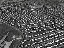
Aerial view of Levittown c.1959
Most of the land on which Levittown is built was purchased in 1951.[6] Levitt and Sons only built six models of houses in Levittown, all single-family dwellings with lawns: the Levittowner, the Rancher, the Jubilee, the Pennsylvanian, the Colonial and the Country Clubber, with only modest exterior variations within each model. The homes were moderately priced and required only a low down payment.
To speed up construction, Levitt & Sons perfected a 26-step rationalized building method that was essentially an assembly line type of home building.[10] The house remained stationary while construction workers moved from site to site, each repeatedly performing a task such as pouring foundations, putting up pre-fabricated walls, installing plumbing, or doing electrical work.[11] At peak production, this highly regimented process enabled Levitt's workers to produce a finished house every sixteen minutes.[12] Construction of the homes commenced in 1952 and when completed in 1958, 17,477 homes had been built.[12]
What set Levittown apart from other developments at the time was that it was built as a complete community. Levitt & Sons designed neighborhoods with traffic-calming curvilinear roads, in which there were no four-way intersections. Each neighborhood had within its boundaries a site donated by Levitt & Sons for a public elementary school. Locations for churches and other public facilities were set aside on main thoroughfares such as the Levittown Parkway, likewise donated by the builder to religious groups and other organizations.
Other amenities included Olympic-sized public pools, parks, greenbelts, baseball fields and playgrounds, and a shopping center located in neighboring Tullytown borough that was considered large and modern at the time of its construction (and in fact was the largest east of the Mississippi). The first set of four sample homes were put on display in a swatch of land near the future Levittown Shop-a-Rama, and an estimated 30,000 people viewed them in that first weekend.[13]
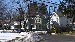
Residents, who are sometimes called Levittowners, were first expected to comply with a lengthy list of rules and regulations regarding the upkeep of their homes and use of their property. Two of these "rules" included a prohibition on hanging laundry out to dry on Sunday and not allowing homeowners to fence off their yards. These proved unenforceable over time, particularly when backyard pools became financially accessible to the working class and privacy concerns drove many to fence off their yards.[14] In the years since Levitt & Sons ended construction, three- and four-story "garden apartments" and a number of non-Levitt owner-occupied houses have been built in Levittown.
William Levitt had a career-long commitment to a whites-only policy in their developments.[dubious–discuss] Levitt & Sons would not sell homes to African Americans. Levitt did not consider himself to be a racist, considering housing and racial relations entirely separate matters. Initially, the Federal Housing Administration (FHA) conditioned essential financing for this and similar projects on the restriction of home sales to those of "the Caucasian race", as stipulated in housing rent and sales agreements and deed covenants.[15] This did not prevent Bea and Lew Wechsler, a Jewish couple from the Bronx, from connecting an African-American family to a neighbor who desired to sell his home. Levittown's first Black couple, William and Daisy Myers, bought a home in the Dogwood Hollow section in 1957.[16] Their move to Levittown was marked with racist harassment and mob violence, which required intervention by state authorities.[17] This led to an injunction and criminal charges against the harassers while the Myerses and their supporters refused to surrender and received national acclaim for their efforts. For instance, Daisy Myers has been hailed as "The Rosa Parks of the North",[18] who helped expose the northern states' problems with racial inequality of that time. Daisy Myers later wrote a book about her family's experiences.[19] She died Dec. 5, 2011, in York, Pa.[20] The NAACP and the ACLU opposed Levitt’s racist policies, and the Federal Housing Administration threatened to refuse mortgages on his next Levittown. Levitt still refused to sell to blacks, and developed plans for yet another whites-only Levittown—this one to be in Willingboro Township, N.J.—while fighting legal challenges in New Jersey courts. Ultimately the U.S. Supreme Court refused to hear his case.[21]
The community's otherwise placid exterior was again disturbed during the so-called suburban gas riots of June 1979 in the wake of the Camp David Peace Accords, which resulted in a second embargo by Arab oil-producing nations. The unrest occurred June 24–25, 1979, as lines swelled and tempers flared in the heart of Levittown at an intersection known as Five Points, a location surrounded by six service stations, two of which were severely damaged by vandalism in the riots. The two days of riots made national headlines and were mentioned (although not directly by name) in the draft of an address to the nation that was to have been delivered by President Jimmy Carter on July 5, 1979.[22]
Of the five public pools built by Levitt & Sons and operated by the Levittown Public Recreation Association (LPRA), four were closed[why?] in 2002, with the exception being one located in the Pinewood section. LPRA Headquarters (and other landmarks) of this prototypical post-war suburb of sometimes mythic importance have been the focus of historic preservation efforts. Since 2002, studies have been underway to establish the Levittown Historic District.
Since its inception in 1988, the Bucks County St. Patrick's Day Parade has been held in Levittown. Every year, the parade steps off from St Joseph the Worker Church[needs update], and proceeds two miles (3km) on New Falls Road to Conwell-Egan Catholic High School. St Joseph the Worker Church has since been torn down.
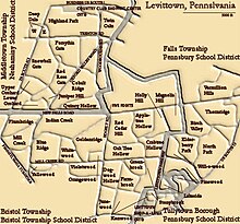
Map of the municipalities, school districts and original sections of Levittown; the thick gray lines are municipal borders.
Levittown is not an incorporated place, though efforts in the early 1950s were made to incorporate. Some Levittown residents feared that incorporation would lead to higher taxes, by robbing the prospective municipality of a commercial tax base.
Levittown Shop-a-Rama, the 1955 Levittown Shopping Center in Tullytown was a 60-acre L-shaped pedestrian mall at the edge rather than the center of Levittown,[23] with two strips of stores faced the 6,000-car parking lot with a courtyard that had green spaces, benches, and entrances to the stores.[23] The center's largest, anchor department store (Pomeroys, which was acquired by Boscov's) and other chain retailers such as Food Fair, Woolworth's, JC Penney, Kresges, Yards, Lobel's, W.T. Grant, Pep Boys, and Sears were Levitt-favored tenants.[23][24][25]
The shopping center began a slow decline in the mid-1970s from which it never recovered with the building of the Oxford Valley Mall. The mall, located just north of Levittown, in Langhorne in Middletown Township, drew shoppers away from the older Levittown facility, given Oxford Valley's much larger size and enclosed shopping environment. In 2002, the redeveloped site of the Shop-a-rama was reopened as the Levittown Town Center. The completed facility contains 468,675 square feet (43,541.3m2) of retail space.[26][27]
Levittown's 41 neighborhoods[28] (locally called "sections") are found in parts of four separate municipalities:
Bristol Township (including the sections of Plumbridge, Mill Creek Falls, Indian Creek, Goldenridge, Blue Ridge, Whitewood, Orangewood, Yellowood, Violetwood, Red Cedar Hill, Apple Tree Hill, Holly Hill, Crabtree Hollow, Oaktree Hollow, Greenbrook, Farmbrook, Dogwood Hollow, Junewood, Magnolia Hill, and most of Kenwood and Stonybrook, and a small part of Birch Valley)
Falls Township (including the sections of Vermilion Hill, Thornridge, Elderberry Pond, Willowood, North Park, as well as portions of Pinewood, Lakeside, most of Birch Valley and 1 house in Magnolia Hill)
Middletown Township (including the sections of Deep Dale East, Deep Dale West, Highland Park, Twin Oaks, Forsythia Gate, Snowball Gate, Red Rose Gate, Upper Orchard, Lower Orchard, Juniper Hill, Cobalt Ridge and Quincy Hollow)
Borough of Tullytown (including small portions of Stonybrook, Kenwood, Pinewood and Lakeside). These neighborhoods' populations are counted by the U.S. Census Bureau as residing within Tullytown only, not the Levittown CDP.
The names of the streets within each section uniformly begin with the same letter that begins the name of the section in question except for the section of Green Lynne, which was not constructed by Bill Levitt. This plan offers a good clue as to where any particular street might be located. "X" and "Z" are not used for section or street names. As there are more than 24 section names, "road" is used for street names in sections to the west of Edgely Road, "lane" is used in those section to the east. Sections are surrounded by a "drive" with the same name as the section. For example, the Pinewood section is circled by Pinewood Drive, while Snowball Gate is surrounded by Snowball Drive. Some sections have their drive broken into multiple parts, with similar names. Forsythia Gate has Forsythia Drive North and Forsythia Drive South.
Almost all other roads or lanes in the sections connect on one or both ends to the drive of that section. In some sections, such as Goldenridge, the shape of the section prevents the drive from surrounding the section, or allowing all roads in the section from connecting to the drive. The drives of adjacent sections, are frequently connected with small connector streets. In addition, small connector streets are used to connect the section drive with a nearby main thoroughfare. The names of these small connectors typically start with one of the letters from the adjacent sections, and tend to have a name reminiscent of their purpose or their location. Some examples: Learning Lane connects Lakeside and Pinewood, and borders Walt Disney Elementary School. Short Lane connects Stoneybrook and Farmbrook. Not all small connector streets are named.
Red Rose Gate, Forsythia Gate, and Snowball Gate are collectively known as "The Gates." (These were the only sections without sidewalks so as to lend a more "executive" appearance to the neighborhoods.) Lakeside sits next to Levittown Lake. Thornridge has its upper half that sits on a ridge, that was found to have Thorn Bushes. Vermilion Hill is named after the color that the trees on its prominent hill turned in the Fall. Magnolia Hill is on a prominent hill. Mill Creek Falls is found next to a creek by the same name.
Levittown is located at 40°9′15″N74°50′59″W / 40.15417°N 74.84972°W / 40.15417; -74.84972.[29] Levittown lies in the southern end of Bucks County ("Lower Bucks"), between Philadelphia and Trenton, New Jersey; Downtown Philadelphia ("Center City") is approximately 22 miles (35km) away. It is part of the Philadelphia metropolitan area (an area also known generally as the Delaware Valley). It is adjacent to and nearly surrounds Fairless Hills, a suburban community more modest in scale, but that shares many of Levittown's characteristics.
Though a steel mill once operated by U.S. Steel provided employment in Falls Township, many Levittown Residents have historically commuted by automobile or train to Philadelphia, Trenton, Princeton and still others to more distant locales in as many as four states. Just over ten percent of employed Levittown Residents both live and work in the community.
As of the 2010 census, Levittown was 87.7% White, 5.1% Hispanic or Latino ancestry of any race, 3.6% Black or African American, 1.7% Asian, 1.6% were two or more races, 0.3% were some other race and 0.2% Native American.[16][34]
As of the census[35] of 2000, there were 53,966 people, 18,603 households, and 14,510 families residing in the CDP. The population density was 5,309.5 inhabitants per square mile (2,050.0/km2). There were 19,044 housing units at an average density of 1,873.7/mi2 (723.7/km2). The racial makeup of the CDP was 94.4% White, 2.4% African American, 2.2% Hispanic or Latino of any race, 1.2% from two or more races, 0.95% Asian, 0.9% from other races, 0.2% Native American and 0.04% Pacific Islander.
There were 18,603 households, out of which 35.8% had children under the age of 18 living with them, 60.7% were married couples living together, 12.3% had a female householder with no husband present, and 22.0% were non-families. 17.8% of all households were made up of individuals, and 8.5% had someone living alone who was 65 years of age or older. The average household size was 2.89 and the average family size was 3.28.
In the CDP, the population was spread out, with 26.4% under the age of 18, 7.8% from 18 to 24, 30.4% from 25 to 44, 20.9% from 45 to 64, and 14.5% who were 65 years of age or older. The median age was 37 years. For every 100 females, there were 96.3 males. For every 100 females age 18 and over, there were 92.6 males.
The median income for a household in the CDP was $52,514, and the median income for a family was $57,220. Males had a median income of $40,411 versus $29,685 for females. The per capita income for the CDP was $20,047. About 3.1% of families and 4.6% of the population were below the poverty line, including 5.6% of those under the age of 18 and 3.5% of those 65 and older.
85.4% of Levittown residents ages 25 or older had at least a high school diploma, while 13.4% had at least a bachelor's degree.
Duncan, Susan Kirsch, Levittown: The Way We Were, Maple Hill Press (1999), ISBN0-930545-18-4
Dubya, Jay (Wiessner), Black Leather and Blue Denim: A '50s Novel, CyberRead Publishing (2001), ISBN1-931921-76-8 (a fictionalized account of "greasers" in Levittown's Dogwood Hollow and Kenwood sections during the 1950s)
Goetz, Sam. Bruno, 16mm black and white film (2006) (Sam Goetz grew up in Lower Orchard section of Levittown; the production was filmed at locations in the "urban wasteland" of Trenton, New Jersey, and at locations in and around Levittown, including Core Creek Park, the former Best Department Store, Neshaminy High School and a Jubilee-style Levittown home)
Harris, Dianne, ed. Second Suburb: Levittown, Pennsylvania (University of Pittsburgh Press; 2010) 429 pages. Scholarly essays, oral histories, and other writings on the town
Hurst, Richard, "My Bay", Christopher Street (New York: February 1994, issue 210), ISSN0146-7921 (written by a former Levittowner about Little League baseball, "the only tradition in our otherwise ahistoric lives of glass-ceiling experimental schools and clean theme-park summers," recounting summers marching as the season began from Carl Sandburg Middle School to the ball fields south of Twin Oaks)
Kimmel, Chad, Levittown, Pennsylvania: A Sociological History, University of Western Michigan Dissertation (2004) (examines the arrival of Levittown's first African-American family, the 1979 gas riots and the decline of the steel industry on local residents)
Krass, Alfred C., "Growing Together in Spirituality: Pastor and Parish Have a Check-Up," Christian Century, (April 1987) (Krass was pastor of the United Christian Church in Levittown, and still a resident of the community; he asks how mainstream Protestants might move beyond the "autonomy of the individual member" that is so often part and parcel of a liberal world view)
Popenoe, David, The Suburban Environment: Sweden and the United States, University of Chicago Press, (1977), ISBN0-226-67542-4 (a comparison of Levittown and Vällingby, Sweden, a Stockholm suburb of similar size, construction date and demographics; see also Hässelby-Vällingby Borough, Vällingby)
Wechshler, Lewis, The First Stone: A Memoir of the Racial Integration of Levittown, Pennsylvania, Grounds for Growth Press (2004), ISBN0-615-12565-4
Bucks County is a county in the Commonwealth of Pennsylvania. As of the 2020 census, the population was 646,538, making it the fourth-most populous county in Pennsylvania. Its county seat is Doylestown. The county is named after the English county of Buckinghamshire.
Levittown is a hamlet and census-designated place (CDP) in the Town of Hempstead in Nassau County, on Long Island, in New York. It is located halfway between the villages of Hempstead and Farmingdale. As of the 2010 census, the CDP had a total population of 51,881, making it the most populous unincorporated CDP in Nassau County and the second most populous CDP on Long Island, behind Brentwood.
Bristol is a borough in Bucks County, Pennsylvania, United States. It is located 23 miles (37 km) northeast of Center City Philadelphia, opposite Burlington, New Jersey on the Delaware River.
Bristol Township is a township in Bucks County, Pennsylvania, United States. The population was 54,582 at the 2010 census, making it the 13th largest municipality in the state. Bristol Township, along with Bristol Borough, is a cultural hub for Lower Bucks County, hosting celebrations of African and Latino heritage. Parts of the township consist of the neighborhoods of Fairless Hills and Levittown. It is located within the Delaware Valley.
Falls Township is a suburban Philadelphia township in Bucks County, Pennsylvania, United States. The population was 34,300 at the 2010 census. Portions of Fairless Hills and Levittown, Pennsylvania, are located in the township. Portions of Falls Township are called Morrisville and Yardley, due to the location of the Morrisville Post Office outside the Borough of Morrisville in Falls Township. As originally chartered in 1692, the villages of Morrisville and Tullytown were part of Falls Township. Morrisville was granted borough status in 1804. Tullytown was established as a borough in 1891.
Langhorne Borough is a borough in Bucks County, Pennsylvania, United States. The population was 1,622 at the time of the 2010 census.
Langhorne Manor is a borough in Bucks County, Pennsylvania, United States. The population was 1,422 at the 2010 census, a 55.6% increase from the 2000 census. The mayor of Langhorne Manor is Bob Byrne.
Middletown Township is a township in Bucks County, Pennsylvania, United States. The population was 46,040 at the 2020 census. Many sections of Levittown are located in the southern end of the township. The municipality surrounds the boroughs of Langhorne, Langhorne Manor, Penndel and Hulmeville; much of the township beyond Levittown uses Langhorne as its mailing address. The township is located within the Delaware Valley, also known as the Philadelphia metropolitan area.
Tullytown is a borough in Bucks County, Pennsylvania, United States. Originally a village in Falls Township, Tullytown was partitioned as a borough in 1891. The population was 1,872 at the 2010 census. Part of Levittown is located in Tullytown.
Warminster Heights is a census-designated place and part of Warminster Township in Bucks County, Pennsylvania, United States. It is located near the eastern border of Hatboro in Montgomery County. The population was 4,124 at the 2010 census.
Paoli is a census-designated place (CDP) in Chester County near Philadelphia, Pennsylvania, United States. It is situated in portions of two townships: Tredyffrin and Willistown. At the 2020 census, it had a total population of 6,002.
Upper Moreland Township is a township in Montgomery County, Pennsylvania. The population was 24,015 at the 2010 census. Upper Moreland Township is a primarily residential community located about 13 miles outside Center City Philadelphia. It is made up of distinctive neighborhoods that are complemented by several thriving business, industrial, and commercial districts.
Wyncote is a census-designated place (CDP) in Cheltenham Township, Montgomery County, Pennsylvania, United States. It borders the northwestern and northeastern section of Philadelphia. Wyncote is located 11 miles from Center City Philadelphia at the southeasternmost tip of Montgomery County. The Jenkintown-Wyncote SEPTA station is the fifth busiest regional rail station in the SEPTA system.
The Delaware Valley, sometimes referred to as Greater Philadelphia or the Philadelphia metropolitan area, is a metropolitan region in the Northeast United States that centers around Philadelphia, the nation's sixth-most populous city, and spans parts of four U.S. states: southeastern Pennsylvania, southern New Jersey, northern Delaware, and the northern Eastern Shore of Maryland. With a core metropolitan statistical area population of 6.288 million residents and a combined statistical area population of 7.366 million as of the 2020 census, the Delaware Valley is the eighth-largest metropolitan region in the nation and North America, and the 68th-largest metropolitan region in the world.
Interstate 295 (I-295) in Delaware, New Jersey, and Pennsylvania is an auxiliary Interstate Highway, designated as a bypass around Philadelphia, Pennsylvania, and a partial beltway of Trenton, New Jersey.
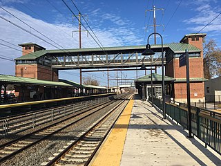
Levittown station is a SEPTA Regional Rail station in Tullytown, Pennsylvania served by the Trenton Line. It opened in 1953 and was rebuilt in 2015–2019. The station has two side platforms serving the outer tracks of the four-track Northeast Corridor.
U.S. Route 1 (US 1) is a major north–south U.S. Route, extending from Key West, Florida, in the south to Fort Kent, Maine, at the Canada–United States border in the north. In the U.S. state of Pennsylvania, US 1 runs for 81 miles (130 km) from the Maryland state line near Nottingham northeast to the New Jersey state line at the Delaware River in Morrisville, through the southeastern portion of the state. The route runs southwest to northeast and serves as a major arterial road through the city of Philadelphia and for many of the suburbs in the Delaware Valley metropolitan area. South of Philadelphia, the road mostly follows the alignment of the Baltimore Pike. Within Philadelphia, it mostly follows Roosevelt Boulevard. North of Philadelphia, US 1 parallels the route of the Lincoln Highway. Several portions of US 1 in Pennsylvania are freeways, including from near the Maryland state line to Kennett Square, the bypass of Media, the concurrency with Interstate 76 and the Roosevelt Expressway in Philadelphia, and between Bensalem Township and the New Jersey state line.
U.S. Route 13 (US 13) is a United States Numbered Highway running from Fayetteville, North Carolina, north to Morrisville, Pennsylvania. The route runs for 49.359 miles (79.436 km) through the Delaware Valley in the U.S. state of Pennsylvania. The route enters the state from Delaware in Marcus Hook, Delaware County. It continues northeast through Delaware County, passing through the city of Chester before heading through suburban areas along Chester Pike to Darby. US 13 enters the city of Philadelphia on Baltimore Avenue and runs through West Philadelphia to University City, where it turns north along several city streets before heading east across the Schuylkill River along Girard Avenue. The route turns north and heads to North Philadelphia, where it runs northeast along Hunting Park Avenue. US 13 becomes concurrent with US 1 on Roosevelt Boulevard, continuing into Northeast Philadelphia. US 13 splits southeast on a one-way pair of streets before heading northeast out of the city on Frankford Avenue. The route continues into Bucks County as Bristol Pike, heading northeast to Bristol, where it turns into a divided highway. US 13 becomes a freeway in Tullytown and continues north to its terminus at US 1 in Falls Township, near Morrisville. US 13 roughly parallels Interstate 95 (I-95) through its course in Pennsylvania.
The Burlington County Times is a daily newspaper located in Westampton, New Jersey, U.S. The paper, which is part of the Gannett chain of newspapers, covers municipal and county issues in Burlington County, New Jersey as well as local and professional sporting events.
Reverend Willie R. James, Sr. served as an important early civil rights activist in New Jersey starting in late 1950s and helped to end housing discrimination in that state. James later became head of the Burlington County Chapter of the National Association for the Advancement of Colored People and remained active in social issues including fighting poverty, job discrimination and ending the death penalty.
↑ "PHMC Historical Markers Search". Pennsylvania Historical and Museum Commission. Commonwealth of Pennsylvania. Archived from the original(Searchable database) on March 21, 2016. Retrieved January 25, 2014.
↑ (DVRPC), Delaware Valley Regional Planning Commission. "DVRPC > Site Search". www.dvrpc.org. Archived from the original on April 9, 2019. Retrieved February 1, 2017.
↑ Frazer, Bear (May 15, 2011). "MMA Valedictorian". fightmagazine.com. Fight! Magazine. Archived from the original on January 18, 2017. Retrieved November 10, 2016.
This page is based on this Wikipedia article Text is available under the CC BY-SA 4.0 license; additional terms may apply. Images, videos and audio are available under their respective licenses.