
Bristol Township is a township in Bucks County, Pennsylvania, United States. The population was 54,582 at the 2010 census, making it the 13th largest municipality in the state. Bristol Township, along with Bristol Borough, is a cultural hub for Lower Bucks County, hosting celebrations of African and Latino heritage. Parts of the township consist of the neighborhoods of Fairless Hills and Levittown. It is located within the Delaware Valley.

Buckingham Township is a township in Bucks County, Pennsylvania, United States. The population was 20,075 at the 2010 census. Buckingham takes its name from Buckingham in Buckinghamshire, England. Buckingham Township was once known as Greenville and was once the historic county seat of the English Bucks County.
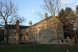
Doylestown Township is a township in Bucks County, Pennsylvania, United States. The population was 17,565 at the 2010 census. Adjacent to the county seat, the township hosts many county offices and the county correctional facility. Doylestown Central Park is a park in the township.

Plumstead Township is a township in Bucks County, Pennsylvania, United States. The population was 12,442 at the 2010 census.

Upper Southampton Township is a township in Bucks County, Pennsylvania, United States. The population was 15,152 at the 2010 census.

Warminster Township, also referred to as Warminster, is located in Bucks County, Pennsylvania, United States. It was formally established in 1711. The township is 13.7 miles north of Philadelphia and had a population of 33,603 according to the 2020 U.S. census.

Warminster Heights is a census-designated place and part of Warminster Township in Bucks County, Pennsylvania, United States. It is located near the eastern border of Hatboro in Montgomery County. The population was 4,124 at the 2010 census.

Warrington Township is a township in Bucks County, Pennsylvania, United States. Warrington Township is a northern suburb of Philadelphia. The population was 25,639 at the 2020 census.

Horsham is a census-designated place in Horsham Township, Montgomery County, Pennsylvania, United States. The population was 15,193 at the 2020 census. It is home to the Biddle Air National Guard Base at the former site of Naval Air Station Joint Reserve Base Willow Grove.

Horsham Township is a home rule municipality in Montgomery County, Pennsylvania. It is located ten miles north of Center City Philadelphia. The township, incorporated in 1717, is one of the oldest original municipalities in Montgomery County. Although it retains the word "Township" in its official name, it has been governed by a Home Rule Charter since 1975 and is therefore not subject to the Pennsylvania Township Code. The population was 26,564 at the time of the 2020 census.

Upper Moreland Township is a township in Montgomery County, Pennsylvania. The population was 24,015 at the 2010 census. Upper Moreland Township is a primarily residential community located about 13 miles outside Center City Philadelphia. It is made up of distinctive neighborhoods that are complemented by several thriving business, industrial, and commercial districts.

Pennsylvania Route 611 is a state highway in eastern Pennsylvania running 109.7 mi (176.5 km) from Interstate 95 (I-95) in the southern part of Philadelphia north to I-380 in Coolbaugh Township in the Pocono Mountains.

William Penn State Forest is a Pennsylvania State Forest in Pennsylvania Bureau of Forestry District #17. The main offices are located in Elverson in Chester County, Pennsylvania in the United States.

Pennsylvania Route 263 (PA 263) is a north–south state highway located in southeast Pennsylvania. The southern terminus of the route is at PA 611 in Willow Grove, Montgomery County. The northern terminus is at the Centre Bridge–Stockton Bridge over the Delaware River in Centre Bridge, Bucks County, where the road continues into Stockton, New Jersey, as Bridge Street to an intersection with Route 29. PA 263 follows the routing of Old York Road, a historic road that connected Philadelphia to New York City, and carries the name York Road from the southern terminus to Lahaska and Upper York Road north of there. From Willow Grove to Buckingham, PA 263 runs mostly through suburban areas as a four-lane road, passing through Hatboro, Warminster, and Jamison. The route forms a concurrency with U.S. Route 202 (US 202) in Buckingham and narrows to a two-lane road, splitting with that route in Lahaska. From here, the route continues through rural areas to Centre Bridge.
Solebury is an unincorporated community in Solebury Township in Bucks County, Pennsylvania, United States. Solebury is located at the intersection of Pennsylvania Route 263, Sugan Road, and Phillips Mill Road.
Furlong is an unincorporated community in Bucks County, Pennsylvania, United States. Furlong is located at the intersection of Pennsylvania Route 263 and Edison-Furlong Road/Forest Grove Road on the border of Buckingham and Doylestown townships.
Danboro is an unincorporated community in Plumstead Township in Bucks County, Pennsylvania, United States. Danboro is located at the intersection of Ferry Road/Danboro Point Pleasant Pike and Old Easton Road, north of Doylestown.
Ottsville is an unincorporated community in Tinicum Township in Bucks County, Pennsylvania, United States, with parts of the community located in neighboring Nockamixon Township. Ottsville is located at the intersection of Creamery Road/Geigel Hill Road and Durham Road, north a short distance east of Pennsylvania Route 611.

Ferndale is an unincorporated community in Nockamixon Township in Bucks County, Pennsylvania, United States. Ferndale is located at the intersection of Pennsylvania Route 611 and Church Hill Road/Center Hill Road.
Durham is an unincorporated community in Durham Township in Bucks County, Pennsylvania, United States. Durham is located at the intersection of Pennsylvania Route 212 and Durham Road.


