Highton, Pennsylvania

Last updated

Highton, Pennsylvania
Populated place
Highton, PA.jpg
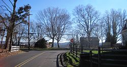
At the intersection of Street Road and Ridge Road
USA Pennsylvania location map.svg
Red pog.svg
Highton, Pennsylvania
Location of Highton in Pennsylvania
Coordinates: 40°19′20″N74°59′19″W / 40.32222°N 74.98861°W / 40.32222; -74.98861
Country United States
State Pennsylvania
County Bucks
Township Buckingham, Solebury
Elevation
[1]
220 ft (67 m)
Time zone UTC-5 (Eastern (EST))
  Summer (DST) UTC-4 (EDT)
Area code 215
FIPS code 42-34668
GNIS feature ID 1203806

Highton is a populated place situated along the border of Buckingham and Solebury townships in Bucks County, Pennsylvania, United States. [2]

Geography

The small settlement is located along Street Road (which runs along the township line) at its intersection with Ridge Road. As the latter road's name implies, it is located along a ridge (at an estimated elevation of 220 feet (67 m) above sea level [1] ) between Pidcock Creek and Curls Run, approximately three and a half miles (5.6 km) southeast of New Hope.

There are a few houses located around the settlement; the remainder consists of farms and properties containing large houses over rolling terrain. [3]

Related Research Articles

<span class="mw-page-title-main">Perry County, Pennsylvania</span> County in Pennsylvania, United States

Perry County is a county in the Commonwealth of Pennsylvania. As of the 2020 census, the population was 45,842. The county seat is New Bloomfield. The county was created on March 22, 1820, and was named for Oliver Hazard Perry, a hero of the War of 1812, who had recently died. It was originally part of Cumberland County and was created in part because residents did not want to travel over the mountain to Carlisle, the county seat of Cumberland County. Landisburg became the temporary county seat before New Bloomfield was ultimately chosen.

<span class="mw-page-title-main">Fulton County, Pennsylvania</span> County in Pennsylvania, United States

Fulton County is a county in the Commonwealth of Pennsylvania. As of the 2020 census, the population was 14,556, making it the fourth-least populous county in Pennsylvania. Its county seat is McConnellsburg. The county was created on April 19, 1850, from a part of Bedford County and named after inventor Robert Fulton.

<span class="mw-page-title-main">Columbia County, Pennsylvania</span> County in Pennsylvania, United States

Columbia County is a county in the Commonwealth of Pennsylvania. It is located in Northeastern Pennsylvania. As of the 2020 census, the population was 64,727. Its county seat is Bloomsburg. The county was created on March 22, 1813, from part of Northumberland County. It was named Columbia, alluding to the United States and Christopher Columbus.

<span class="mw-page-title-main">Bucks County, Pennsylvania</span> County in Pennsylvania, United States

Bucks County is a county in the Commonwealth of Pennsylvania. As of the 2020 census, the population was 646,538, making it the fourth-most populous county in Pennsylvania. Its county seat is Doylestown. The county is named after the English county of Buckinghamshire.

<span class="mw-page-title-main">Bensalem Township, Pennsylvania</span> Township in Pennsylvania, United States

Bensalem Township is a township in Bucks County, Pennsylvania, United States. The township borders the northeastern section of Philadelphia and includes the communities of Andalusia, Bensalem, Bridgewater, Cornwells Heights, Eddington, Flushing, Oakford, Siles, Trappe, and Trevose. Bensalem Township has no other incorporated municipalities within its boundaries. It is located within the Delaware Valley, also known as the Philadelphia metropolitan area.

<span class="mw-page-title-main">Bristol Township, Pennsylvania</span> Township in Pennsylvania, United States

Bristol Township is a township in Bucks County, Pennsylvania, United States. The population was 54,582 at the 2010 census, making it the 13th largest municipality in the state. Bristol Township, along with Bristol Borough, is a cultural hub for Lower Bucks County, hosting celebrations of African and Latino heritage. Parts of the township consist of the neighborhoods of Fairless Hills and Levittown. It is located within the Delaware Valley.

<span class="mw-page-title-main">Buckingham Township, Bucks County, Pennsylvania</span> Township in Pennsylvania, United States

Buckingham Township is a township in Bucks County, Pennsylvania, United States. The population was 20,075 at the 2010 census. Buckingham takes its name from Buckingham in Buckinghamshire, England. Buckingham Township was once known as Greenville and was once the historic county seat of the English Bucks County.

<span class="mw-page-title-main">Northampton Township, Bucks County, Pennsylvania</span> Township in Pennsylvania, United States

Northampton Township is a township in Bucks County, Pennsylvania, United States. The township is located approximately 12 miles northeast of Philadelphia. The population was 39,915 at the 2020 census.

<span class="mw-page-title-main">Tinicum Township, Bucks County, Pennsylvania</span> Township in Pennsylvania, United States

Tinicum Township is a township in Bucks County, Pennsylvania, United States. The population was 3,995 at the 2010 census.

<span class="mw-page-title-main">Montgomery Township, Montgomery County, Pennsylvania</span> Township in Pennsylvania, United States

Montgomery Township is a township in Montgomery County, Pennsylvania. It is the location of the Montgomery Mall, a regional shopping mall serving the Route 309 corridor of the Philadelphia suburbs. Much of Montgomery Township's development is suburban in character, with newer tract houses and strip shopping centers. Homes in Montgomery Township have North Wales and Lansdale addresses, but businesses that are located within the township boundaries are given the Montgomeryville ZIP Code. The township is in the North Penn School District and is part of the North Penn Valley region that is centered around the borough of Lansdale.

<span class="mw-page-title-main">Pennsylvania Route 313</span> State highway in Bucks County, Pennsylvania, US

Pennsylvania Route 313 is a mostly 2-lane, 18-mile-long (29 km) state highway entirely within Bucks County, Pennsylvania. The western end of PA 313 is at an intersection with PA 309 and PA 663 in Quakertown. The eastern end is at an intersection with PA 263 in the Doylestown Township community of Furlong. PA 313 is signed an east–west road, although it runs almost purely northwest–southeast through most of its course. It is a major arterial road in central and northern Bucks County as it connects several communities including Quakertown, Dublin, and Doylestown.

<span class="mw-page-title-main">Pennsylvania Route 663</span> State highway in Pennsylvania, US

Pennsylvania Route 663 (PA 663) is a 22.13-mile-long (35.61 km) state highway in Montgomery and Bucks counties in southeast Pennsylvania. Its southern terminus is at PA 100 in the borough of Pottstown and its northern terminus is at PA 309 and PA 313 in the borough of Quakertown, where the road continues eastward as PA 313. Along the way, PA 663 also passes through the borough of Pennsburg. It is called John Fries Highway between Pennsburg and Quakertown. It has an interchange with Interstate 476 at exit 44 west of Quakertown. The route was assigned in 1930, and it has had several realignments since its commissioning, including two major ones.

<span class="mw-page-title-main">Pennsylvania Route 152</span> State highway in Pennsylvania, US

Pennsylvania Route 152 (PA 152) is a 25.3-mile-long (40.7 km) state highway located in the U.S. state of Pennsylvania. The route travels north–south from an interchange with PA 309 located in the Cedarbrook neighborhood of Cheltenham Township in Montgomery County north to another interchange with PA 309 located northeast of Telford in Bucks County. PA 152 is known as Limekiln Pike for most of its length. From the southern terminus, the route passes through suburban areas to the north of Philadelphia, serving Dresher, Maple Glen, and Chalfont. North of Chalfont, PA 152 runs through rural suburbs of Philadelphia before reaching Silverdale. Past here, the road continues northwest through Perkasie, where it turns southwest and passes through Sellersville before reaching its northern terminus.

<span class="mw-page-title-main">Pennsylvania Route 413</span> State highway in Bucks County, Pennsylvania, United States

Pennsylvania Route 413 is a 31-mile-long (50 km), north–south state highway in Bucks County, Pennsylvania. The route runs from the New Jersey state line on the Burlington–Bristol Bridge over the Delaware River outside Bristol, where the road continues as Route 413 into New Jersey, north to PA 611 in Bedminster Township. The route passes through the lower and central portions of Bucks County, serving Bristol, Levittown, Langhorne, Newtown, and Buckingham. The route intersects U.S. Route 13 and Interstate 95 (I-95) near Bristol, I-295 near Penndel, US 1 in Langhorne Manor, and US 202 in Buckingham.

<span class="mw-page-title-main">Pennsylvania Route 563</span> State highway in the U.S. state of Pennsylvania

Pennsylvania Route 563 (PA 563) is a state highway in the U.S. state of Pennsylvania. The route runs 21.15 mi (34.04 km) from PA 63 in Upper Salford Township northeast to PA 412 in Nockamixon Township. The road runs through mostly rural areas in the northern parts of Montgomery and Bucks counties. Along the way, the route passes through the northern part of Perkasie and forms a concurrency with PA 313 in East Rockhill Township. North of here, PA 563 runs through Nockamixon State Park, heading to the northwest of Lake Nockamixon.

<span class="mw-page-title-main">U.S. Route 202 Business (Montgomeryville–Doylestown, Pennsylvania)</span>

U.S. Route 202 Business is a 10-mile (16 km) business route of US 202 in Montgomery and Bucks counties in the U.S. state of Pennsylvania, running between Montgomeryville and Doylestown. The route heads northeast from US 202 in Upper Gwynedd Township along five-lane Dekalb Pike through residential and commercial areas. In Montgomeryville, the route turns north to run concurrent with Pennsylvania Route 309 on five-lane Bethlehem Pike past several businesses. US 202 Bus. splits from PA 309 by turning northeast onto two-lane Doylestown Road. The route crosses into Bucks County and becomes Butler Avenue, passing through Chalfont and New Britain and curving east. West of Doylestown, the business route ends at an interchange with PA 611 in Doylestown Township.

Hiestand is a populated place situated in East Vincent Township in Chester County, Pennsylvania, United States. It has an estimated elevation of 361 feet (110 m) above sea level. Hiestand is located at the intersection of Ellis Woods, Sheeder, and Ridge Roads.

<span class="mw-page-title-main">Hood, Pennsylvania</span> Populated place in Pennsylvania, United States

Hood is a populated place that is located in New Hope, a borough in Bucks County, Pennsylvania, United States.

Applebachsville is a populated place in Haycock Township, Bucks County, Pennsylvania, United States, located 2.6 miles (4.2 km) northeast of Richlandtown.

Aquetong is populated place in Solebury Township, Bucks County, Pennsylvania, United States, situated along U.S. Route 202, approximately 2.9 miles (4.7 km) west of New Hope.

References

  1. 1 2 "Feature Detail Report for: Highton". Geographic Names Information System . United States Geological Survey, United States Department of the Interior.
  2. "Highton (in Bucks County, PA) Populated Place Profile". PA Hometown Locator. Retrieved December 18, 2015.
  3. Google (December 26, 2015). "Aerial view of Highton" (Map). Google Maps . Google. Retrieved December 26, 2015.