List of bridges in the Netherlands

Last updated

This list of bridges in the Netherlands lists bridges of particular historical, scenic, architectural or engineering interest in the Netherlands. Road and railway bridges, viaducts, aqueducts and footbridges are included.

Contents

Historical and architectural interest bridges

NameDistinctionLengthTypeCarries
Crosses
OpenedLocationProvinceRef.
Magere Brug.jpg 1 Magere Brug Rijksmonument80 m (260 ft) Beam bridge
Drawbridge
Footbridge
Amstel
1670 Amsterdam
52°21′48.9″N4°54′8.5″E / 52.363583°N 4.902361°E / 52.363583; 4.902361 (Magere Brug)
North Holland [B 1]
[S 1]
[1]
Amsterdam Python Bridge 08.jpg 2 Python Bridge Truss
Steel
Footbridge
IJ
2000 Amsterdam
52°22′22.8″N4°56′56″E / 52.373000°N 4.94889°E / 52.373000; 4.94889 (Passerelle cycliste entre les îles Borneo et Sporenburg)
North Holland [B 2]
[S 2]
[2]
Slauerhoffbrug 'Flying' Drawbridge by Hindrik 1.jpg 3 Slauerhoffbrug 15 m (49 ft) Beam bridge
Steel
Tilt bridge
Road bridge
Harlingervaart
2000 Leeuwarden
53°11′55.1″N5°45′57.1″E / 53.198639°N 5.765861°E / 53.198639; 5.765861 (Slauerhoffbrug)
Friesland [B 3]
[S 3]
Enneusheermabrug.jpg 4 Enneüs Heerma Bridge 205 m (673 ft) Arch
Steel tied arch
Bow-string bridge
S114
IJtram
IJ
2001 Amsterdam
52°21′54.2″N4°58′36.2″E / 52.365056°N 4.976722°E / 52.365056; 4.976722 (Pont Enneüs Heerma)
North Holland [S 4]
Calatrava luit.jpg 5 De Luit Bridge Designed by Santiago Calatrava Cable-stayed
Steel deck, steel inclined pylon
Road bridge
Hoofdvaart
2004 Haarlemmermeer
52°17′25.9″N4°40′17.1″E / 52.290528°N 4.671417°E / 52.290528; 4.671417 (Pont le Luth)
North Holland [S 5]
Calatrava harp.jpg 6 De Harp Bridge Designed by Santiago Calatrava 143 m (469 ft) Cable-stayed
Steel deck, steel inclined pylon
Road bridge
Hoofdvaart
2004 Haarlemmermeer
52°16′22″N4°38′44.5″E / 52.27278°N 4.645694°E / 52.27278; 4.645694 (Pont la Harpe)
North Holland [S 6]
Calatrava citer.jpg 7 De Citer Bridge Designed by Santiago Calatrava 149 m (489 ft) Cable-stayed
Steel deck, steel inclined pylon
Road bridge
Hoofdvaart
2004 Haarlemmermeer
52°17′2.7″N4°39′41.3″E / 52.284083°N 4.661472°E / 52.284083; 4.661472 (Pont la Cithare)
North Holland [S 7]
Nesciobrug 3.jpg 8 Nesciobrug Span : 170 m (560 ft) Suspension
Steel box girder deck, steel pylons
2006 Diemen
52°21′23.4″N4°58′10.1″E / 52.356500°N 4.969472°E / 52.356500; 4.969472 (Pont Nescio)
North Holland [B 4]
Bridge in Utrecht.jpg 9 Rode brug  [ nl ]10 m (33 ft) Beam bridge
Steel
Drawbridge
Road bridge
Vecht
2009 Utrecht
52°6′23.1″N5°6′26.2″E / 52.106417°N 5.107278°E / 52.106417; 5.107278 (Rode brug)
Utrecht [B 5]
[S 8]

Major road and railway bridges

NameSpanLengthTypeCarries
Crosses
OpenedLocationProvinceRef.
Van Brienenoordbrug.jpg 1 Van Brienenoord Bridge 287 m (942 ft)1,306 m (4,285 ft) Arch
Steel tied arch
Bow-string bridge
1965 Rotterdam
51°54′12″N4°32′35.7″E / 51.90333°N 4.543250°E / 51.90333; 4.543250 (Van Brienenoord Bridge)
South Holland [B 6]
[S 9]
Nijmegen - Waal - De Oversteek (26223244138).jpg 2 De Oversteek  [ nl ]285 m (935 ft)1,400 m (4,600 ft) Arch
Steel tied arch
Bow-string bridge
Stadsroute 100
Waal
2013 Nijmegen
51°51′29.8″N5°50′28.8″E / 51.858278°N 5.841333°E / 51.858278; 5.841333 (De Oversteek)
Gelderland [S 10]
Rotterdam erasmusbrug.jpg 3 Erasmusbrug 278 m (912 ft)802 m (2,631 ft) Cable-stayed
Steel deck, steel pylon
Stadsroute 106
Stadsroute 122
Rotterdam Tramway
(lines 12, 20, 23, 25)
Nieuwe Maas
1996 Rotterdam
51°54′32.2″N4°29′14.1″E / 51.908944°N 4.487250°E / 51.908944; 4.487250 (Erasmusbrug)
South Holland [B 7]
[S 11]
Tacitusbrug-1edit.jpg 4 Tacitusbrug  [ nl ]270 m (890 ft)1,055 m (3,461 ft) Cable-stayed
East: steel deck and pylons, axial cable-stays
West: concrete deck and pylons
105+270+105
1975
2013
Beuningen
51°53′7.5″N5°44′16.6″E / 51.885417°N 5.737944°E / 51.885417; 5.737944 (Tacitusbrug)
Gelderland [B 8]
[S 12]
Rotterdam 'Willemsbrug'.jpg 5 Willemsbrug 270 m (890 ft)318 m (1,043 ft) Cable-stayed
Steel deck, steel pylons
Stadsroute 123
Nieuwe Maas
1981 Rotterdam
51°55′1.4″N4°29′45.2″E / 51.917056°N 4.495889°E / 51.917056; 4.495889 (Willemsbrug)
South Holland [B 9]
[S 13]
Bij Beneden Leeuwen, de Prins Willem Alexanderbrug IMG 2693 2019-10-26 13.07.jpg 6 Prince Willem-Alexander Bridge  [ nl ]267 m (876 ft)1,419 m (4,656 ft) Cable-stayed
Concrete deck, pylons and cable-stays
95+267+95
Provincial road 323
Waal
1972 Echteld
51°53′20.3″N5°29′51″E / 51.888972°N 5.49750°E / 51.888972; 5.49750 (Prince Willem-Alexander Bridge)
Gelderland [B 10]
[S 14]
Martinus Nijhoff brug R-700 0158 ACR-7-2.jpg 7 Martinus Nijhoff Bridge  [ nl ]256 m (840 ft)990 m (3,250 ft) Cable-stayed
Concrete deck and pylons
1996 Zaltbommel
51°49′5.3″N5°15′36.3″E / 51.818139°N 5.260083°E / 51.818139; 5.260083 (Martinus Nijhoff Bridge)
Gelderland [B 11]
[S 15]
Spoorbrug Muiderberg op zijn definitieve plek.jpg 8 Zandhazen Bridge  [ nl ]255 m (837 ft)255 m (837 ft) Arch
Steel tied arch
Bow-string bridge
2016 Muiderberg
52°19′00.6″N5°05′56.8″E / 52.316833°N 5.099111°E / 52.316833; 5.099111 (Zandhazen Bridge)
North Holland [S 16]
Overzicht van de Waalbrug over de Waal - Nijmegen - 20425651 - RCE2.jpg 9 Waalbrug 244 m (801 ft)604 m (1,982 ft) Arch
Steel through arch
Provincial road 325
Waal
1936 Nijmegen
51°51′4.6″N5°52′16.5″E / 51.851278°N 5.871250°E / 51.851278; 5.871250 (Waalbrug)
Gelderland [B 12]
[S 17]
Werkspoorbrug.jpg 10 Werkspoor Bridge (Amsterdam–Rhine Canal)  [ nl ]237 m (778 ft)255 m (837 ft) Arch
Steel tied arch
Bow-string bridge
2002 Utrecht
52°6′36.9″N5°4′36.7″E / 52.110250°N 5.076861°E / 52.110250; 5.076861 (Werkspoor Bridge)
Utrecht [B 13]
[S 18]
Nijmegen - Brug.jpg 11 Nijmegen railway bridge 235 m (771 ft)375 m (1,230 ft) Truss
Steel
1983 Nijmegen
51°51′7.2″N5°51′23.8″E / 51.852000°N 5.856611°E / 51.852000; 5.856611 (Nijmegen railway bridge)
Gelderland [B 14]
[S 19]
Papendrecht, brug tussen Papendrecht en Dordrecht foto5 2010-06-27 17.06.JPG 12 Merwede Bridge (Beneden Merwede)  [ nl ]202 m (663 ft)1,032 m (3,386 ft) Arch
Steel tied arch
Bow-string bridge
1967 Papendrecht
51°51′22.7″N4°39′14.9″E / 51.856306°N 4.654139°E / 51.856306; 4.654139 (Merwede Bridge (Beneden Merwede))
South Holland [S 20]
Kampen cable stayed bridge over the IJsselriver at a sunny 30 Januari 2014 - panoramio.jpg 13 Molenbrug (Kampen)  [ nl ]193 m (633 ft)627 m (2,057 ft) Cable-stayed
Steel deck, steel pylons
Twin bridges
91+193+91
1983 Kampen
52°32′31.2″N5°55′55.8″E / 52.542000°N 5.932167°E / 52.542000; 5.932167 (Molenbrug (Kampen))
Overijssel [B 15]
[S 21]
Dintelhavenbrug in N15 en Dintelhavenspoorbrug - RWS 437165.jpg 14 Dintelhaven Bridge  [ nl ]192 m (630 ft) Box girder
Prestressed concrete
Twin bridges
80+151+80
NL-A15.svg
A15 motorway
Dintelhaven
2001 Rotterdam
51°56′9.5″N4°8′30.5″E / 51.935972°N 4.141806°E / 51.935972; 4.141806 (Dintelhaven Bridge)
South Holland [B 16]
[S 22]
Railwaybridge over the Amsterdam-Rhine canal at Houten Schalkwijk - panoramio.jpg 15 Schalkwijkse Railway Bridge  [ nl ]188 m (617 ft) Arch
Steel tied arch
1976 Schalkwijk
52°0′21.8″N5°11′6.5″E / 52.006056°N 5.185139°E / 52.006056; 5.185139 (Schalkwijkse Railway Bridge)
Utrecht [B 17]
Tussen Driemond en Weesp, brug over Amsterdam Rijnkanaal foto4 2011-10-23 13.42-2.JPG 16 Muider Railway Bridge  [ nl ]188 m (617 ft)251 m (823 ft) Arch
Steel tied arch
Bow-string bridge
1995 Diemen Weesp
52°19′28.9″N5°1′3″E / 52.324694°N 5.01750°E / 52.324694; 5.01750 (Muider Railway Bridge)
North Holland [B 18]
[S 23]
De van Galecopperbrug over het Amsterdam Rijnkanaal bij Utrecht ID167171.jpg 17 Galecopperbrug  [ nl ]180 m (590 ft)320 m (1,050 ft) Cable-stayed
Steel deck, steel pylons
Twin bridges
70+180+70
1974 Utrecht
52°3′38.4″N5°5′51.6″E / 52.060667°N 5.097667°E / 52.060667; 5.097667 (Galecopperbrug)
Utrecht [B 19]
[S 24]
Demka spoorbrug 1.jpg 18 Demka Railway Bridge  [ nl ]173 m (568 ft)255 m (837 ft) Arch
Steel tied arch
1970 Utrecht
52°06′37.7″N5°04′37.4″E / 52.110472°N 5.077056°E / 52.110472; 5.077056 (Demka Railway Bridge)
Utrecht [3]
19 Vleutense Railway Bridge  [ nl ]172 m (564 ft)172 m (564 ft) Arch
Steel tied arch
Bow-string bridge
2018 Utrecht
52°05′52.8″N5°04′37.5″E / 52.098000°N 5.077083°E / 52.098000; 5.077083 (Vleutense Railway Bridge)
Utrecht [S 25]
Merwedebrug - RWS 364426.jpg 20 Merwede Bridge (Boven Merwede)  [ nl ]170 m (560 ft)(x2)340 m (1,120 ft) Arch
Steel tied arch
Bow-string bridge
1961 Gorinchem Sleeuwijk
51°49′38.1″N4°56′32.8″E / 51.827250°N 4.942444°E / 51.827250; 4.942444 (Merwede Bridge (Boven Merwede))
South Holland
North Brabant
[B 20]
[S 26]
Europoort, railwaybridge in steel with constructive interessant details between the arch and the girder - panoramio.jpg 21 Dintelhaven Railway Bridge  [ nl ]170 m (560 ft)270 m (890 ft) Arch
Steel tied arch
Bow-string bridge
Betuweroute
Dintelhaven
1999 Rotterdam
51°56′10.5″N4°8′26.6″E / 51.936250°N 4.140722°E / 51.936250; 4.140722 (Dintelhaven Railway Bridge)
South Holland [B 21]
[S 27]
Hogeweidebrug mei 2017.jpg 22 Hogeweide Bridge  [ nl ]170 m (560 ft)170 m (560 ft) Arch
Steel tied arch
Bow-string bridge
2007 Utrecht
52°5′51.7″N5°4′37.4″E / 52.097694°N 5.077056°E / 52.097694; 5.077056 (Hogeweide Bridge)
Utrecht [S 28]
Jan Blankenbrug in A2 naast oude Lekbrug.jpg 23 Jan Blanken Bridge (Vianen)  [ nl ]165 m (541 ft)532 m (1,745 ft) Box girder
Prestressed concrete
Twin bridges
1999
2003
Nieuwegein Vianen
51°59′51.2″N5°4′40.2″E / 51.997556°N 5.077833°E / 51.997556; 5.077833 (Jan Blanken Bridge (Vianen))
Utrecht [B 22]
[B 23]
[S 29]
1398 Muiden, Netherlands - panoramio (6).jpg 24 Muider Bridge  [ nl ]162 m (531 ft)300 m (980 ft) Box girder
Steel
Twin bridges
1972 Muiden
52°19′56.7″N5°00′53.4″E / 52.332417°N 5.014833°E / 52.332417; 5.014833 (Muider Bridge)
North Holland [S 30]
[4]
20140918 Stichtse Brug.jpg 25 Stichtse Bridge  [ nl ]160 m (520 ft)325 m (1,066 ft) Box girder
Prestressed concrete
Twin bridges
1997 Almere Huizen
52°18′13.1″N5°18′52.3″E / 52.303639°N 5.314528°E / 52.303639; 5.314528 (Stichtse Bridge)
Flevoland
North Holland
Linden (Cuijk, N-Br) - Heumen (Gld) bridge of A73 over Meuse river.JPG 26 Heumen Highway Bridge 157 m (515 ft)658 m (2,159 ft) Box girder
Prestressed concrete
Twin bridges
1981 Heumen Linden
52°22′41.5″N4°57′59.6″E / 52.378194°N 4.966556°E / 52.378194; 4.966556 (Heumen Highway Bridge)
Gelderland
North Brabant
[B 24]
[S 31]
Overzicht spoorbrug gezien vanuit het noorden - Culemborg - 20375605 - RCE.jpg 27 Old Kuilenburg Railway Bridge  [ nl ]154 m (505 ft)667 m (2,188 ft) Truss
Steel
1867 Culemborg
51°57′38″N5°12′48.3″E / 51.96056°N 5.213417°E / 51.96056; 5.213417 (Old Kuilenburg Railway Bridge)
Gelderland [B 25]
[S 32]
ENI 03010572 JONGE JAN IV (07).JPG 28 Kuilenburg Railway Bridge  [ nl ]154 m (505 ft)667 m (2,188 ft) Arch
Steel tied arch
Bow-string bridge
1982 Culemborg
51°57′38.1″N5°12′48.7″E / 51.960583°N 5.213528°E / 51.960583; 5.213528 (Kuilenburg Railway Bridge)
Gelderland [S 33]
A2 - Jan Blankenbrug, Lekbrug - RWS 421290.jpg 29 Vianen Bridge (1936)  [ nl ]
closed in 2004
153 m (502 ft)532 m (1,745 ft) Arch
Steel tied arch
Bow-string bridge

Lek
1936 Nieuwegein Vianen
51°57′38.1″N5°12′48.7″E / 51.960583°N 5.213528°E / 51.960583; 5.213528 (Vianen Bridge (1936))
Utrecht [S 34]
The new Uyllander bridge at Amsterdam IJburg-Diemen with lots of water for nature development - panoramio.jpg 30 Uyllander Bridge  [ nl ]152 m (499 ft)362 m (1,188 ft) Arch
Steel tied arch
Bow-string bridge
Stadsroute 114
Amsterdam–Rhine Canal
2014 Diemen
52°20′12.0″N5°00′32.7″E / 52.336667°N 5.009083°E / 52.336667; 5.009083 (Uyllander Bridge)
North Holland [S 35]
Nieuwe IJsselbrug.jpg 31 New Bridge over the IJssel (Zwolle)  [ nl ]150 m (490 ft)644 m (2,113 ft) Box girder
Prestressed concrete
1970 Zwolle Hattem
52°29′59.3″N6°3′15.3″E / 52.499806°N 6.054250°E / 52.499806; 6.054250 (New Bridge over the IJssel (Zwolle))
Overijssel
Gelderland
[S 36]
32 Rooyensteinsebrug 150 m (490 ft)308 m (1,010 ft) Box girder
Prestressed concrete
Provincial road 835
Amsterdam–Rhine Canal
1977 Tiel
51°55′24.2″N5°25′34.3″E / 51.923389°N 5.426194°E / 51.923389; 5.426194 (Rooyensteinsebrug)
Gelderland [B 26]
Eilandbrug Kampen Panorama2.jpg 33 Eiland Bridge (Overijssel)  [ nl ]150 m (490 ft)412 m (1,352 ft) Cable-stayed
Composite steel/concrete deck, concrete pylon
2003 Kampen
52°34′59″N5°51′32.7″E / 52.58306°N 5.859083°E / 52.58306; 5.859083 (Eiland Bridge (Overijssel))
Overijssel [B 27]
[S 37]
The Ben van Berkel cable stayed bridge across the Amsterdam-Rhine canal Utrecht more in detail - panoramio.jpg 34 Prince Claus Bridge (Utrecht)  [ nl ]150 m (490 ft)230 m (750 ft) Cable-stayed
Composite steel/concrete deck, steel pylon
2003 Utrecht
52°4′15.6″N5°5′17.2″E / 52.071000°N 5.088111°E / 52.071000; 5.088111 (Prince Claus Bridge (Utrecht))
Utrecht [B 28]
[S 38]
The opened new railwaybridge near Hattem, see also photo-http-www.panoramio.com-photo-46770863 at last year - panoramio.jpg 35 Hanzeboog  [ nl ]150 m (490 ft)926 m (3,038 ft) Arch
Steel tied arch
Bow-string bridge
75+150+75
2011 Zwolle Hattem
52°29′23.6″N6°3′43.4″E / 52.489889°N 6.062056°E / 52.489889; 6.062056 (Hanzeboog)
Overijssel
Gelderland
[S 39]
Nederland Bleiswijk september 2005 ID297539.jpg 36 Bleiswijk Railway Bridge  [ nl ]5,500 m (18,000 ft) Box girder
Prestressed concrete
2004 Bleiswijk
52°2′20.2″N4°31′43.5″E / 52.038944°N 4.528750°E / 52.038944; 4.528750 (Bleiswijk Railway Bridge)
South Holland [S 40]
Around zeelandbrug (23).jpg 37 Zeeland Bridge 95 m (312 ft)5,022 m (16,476 ft) Box girder
Prestressed concrete
Provincial road 256
Eastern Scheldt
1965 Schouwen-Duiveland Noord-Beveland
51°36′47.6″N3°53′33.4″E / 51.613222°N 3.892611°E / 51.613222; 3.892611 (Zeeland Bridge)
Zeeland [B 29]
[S 41]

Notes and references

  1. "Brug nr. 242, Magere Brug". Archived from the original on 13 May 2016.
  2. "Brug nr. 1997, Borneo Sporenbrug". Archived from the original on 13 May 2016.
  3. "Slauerhoffbrug, Leeuwarden". Archived from the original on 13 May 2016.
  4. "Brug nr. 2013, Nesciobrug, Amsterdam". Archived from the original on 13 May 2016.
  5. "Rode brug Utrecht 2009". Archived from the original on 13 May 2016.
  6. "Boogbrug Van Brienenoord 1e, Rotterdam)". Archived from the original on 13 May 2016.
  7. "Erasmusbrug(tuibrug+ basculebrug)". Archived from the original on 13 May 2016.
  8. "Ewijk (tuibrug)". Archived from the original on 13 May 2016.
  9. "Willemsbrug". Archived from the original on 13 May 2016.
  10. "Prins Willem Alexander brug". Archived from the original on 13 May 2016.
  11. "Martinus Nijhoffbrug". Archived from the original on 13 May 2016.
  12. "Waalbrug VB(boogbrug)". Archived from the original on 16 July 2018.
  13. "Werkspoorbrug(2002)". Archived from the original on 13 May 2016.
  14. "Spoorbrug Nijmegen". Archived from the original on 13 May 2016.
  15. "Molenbrug Kampen". Archived from the original on 24 July 2018.
  16. "Dintelhaven VB". Archived from the original on 20 August 2018.
  17. "Schalkwijkse spoorbrug". Archived from the original on 13 May 2016.
  18. "Muiderspoorbrug o/h A'dam-Rijnkanaal". Archived from the original on 24 July 2018.
  19. "Galecopperbrug". Archived from the original on 13 May 2016.
  20. "Merwedebrug". Archived from the original on 13 May 2016.
  21. "Dintelhavenbrug SB". Archived from the original on 24 July 2018.
  22. "Jan Blanckenbrug (1999)". Archived from the original on 24 July 2018.
  23. "Jan Blanckenbrug (2003)". Archived from the original on 24 July 2018.
  24. "Maasbrug bij Heumen". Archived from the original on 24 July 2018.
  25. "Spoorbrug Culemborg". Archived from the original on 13 May 2016.
  26. "Rooyensteinsebrug". Archived from the original on 24 July 2018.
  27. "Eilandbrug". Archived from the original on 18 July 2018.
  28. "Prins Claus brug Utrecht". Archived from the original on 13 May 2016.
  29. "Zeelandbrug". Archived from the original on 13 May 2016.
  1. "Monumentnummer: 518383 Magere brug te Amsterdam". monumentenregister.cultureelerfgoed.nl - Cultural Heritage Agency (in Dutch).
  2. "Bridges Borneo-Sporenburg, Amsterdam, NL". west8.com.
  3. "De DEMKA-spoorbrug over het Amsterdam-Rijnkanaal" [The DEMKA railway bridge over the Amsterdam-Rhine Canal]. usine-utrecht.nl (in Dutch).
  4. "Muiderbrug". benthemcrouwel.com.

See also

Map all coordinates using: OpenStreetMap

Further reading

Related Research Articles

<span class="mw-page-title-main">Nijmegen</span> City and municipality in Gelderland, Netherlands

Nijmegen is the largest city in the Dutch province of Gelderland and the tenth largest of the Netherlands as a whole. Located on the Waal River close to the German border, Nijmegen is the oldest city in the Netherlands and the first to be recognized as such in Roman times. In 2005, it celebrated 2,000 years of existence.

<span class="mw-page-title-main">Rhine</span> Major river in Western Europe

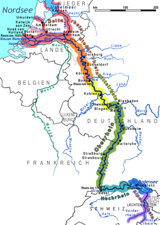
The Rhine is one of the major European rivers. The river begins in the Swiss canton of Graubünden in the southeastern Swiss Alps. It forms part of the Swiss-Liechtenstein, Swiss-Austrian, and Swiss-German borders. After that the Rhine defines much of the Franco-German border, after which it flows in a mostly northerly direction through the German Rhineland. Finally in Germany, the Rhine turns into a predominantly westerly direction and flows into the Netherlands where it eventually empties into the North Sea. It drains an area of 9,973 sq km and its name derives from the Celtic Rēnos. There are also two German states named after the river, North Rhine-Westphalia and Rhineland-Palatinate.

<span class="mw-page-title-main">Overijssel</span> Province of the Netherlands

Overijssel is a province of the Netherlands located in the eastern part of the country. The province's name translates to "across the IJssel", from the perspective of the Episcopal principality of Utrecht by which it was held until 1528. The capital city of Overijssel is Zwolle and the largest city is Enschede. The province had a population of 1,162,215 as of November 2019. The land mostly consists of grasslands and some forests ; it also borders a small part of the IJsselmeer to the west.

<span class="mw-page-title-main">Gelderland</span> Province of the Netherlands

Gelderland, also known as Guelders in English, is a province of the Netherlands, occupying the centre-east of the country. With a total area of 5,136 km2 (1,983 sq mi) of which 173 km2 (67 sq mi) is water, it is the largest province of the Netherlands by land area, and second by total area. Gelderland shares borders with six other provinces and the German state of North Rhine-Westphalia.

<span class="mw-page-title-main">Zwolle</span> City and municipality in Overijssel, Netherlands

Zwolle is a city and municipality in the Northeastern Netherlands. It is the capital of the province of Overijssel and the province's second-largest municipality after Enschede with a population of 130,592 as of 1 December 2021. Zwolle borders on the province of Gelderland and is east of the river IJssel.

<span class="mw-page-title-main">IJssel</span> River in the Netherlands

The IJssel is a Dutch distributary of the river Rhine that flows northward and ultimately discharges into the IJsselmeer, a North Sea natural harbour. It more immediately flows into the east-south channel around the Flevopolder, Flevoland which is kept at 3 metres below sea level. This body of water is then pumped up into the IJsselmeer.

<span class="mw-page-title-main">Brummen</span> Municipality in Gelderland, Netherlands

Brummen is a municipality and a village in the eastern Netherlands.

<span class="mw-page-title-main">Culemborg</span> City and municipality in Gelderland, Netherlands

Culemborg is a municipality and a city in the centre of the Netherlands. The city had a population of 29,386 on 1 January 2022 and is situated just south of the Lek river. Direct train lines run from the railway station towards the cities of Utrecht and Den Bosch.

<i>Van der Valk</i> British TV crime drama set in Amsterdam

Van der Valk is a British television crime drama series produced for the ITV network. It ran from 1972 to 1992, with the first three series produced between 1972 and 1977, and two more being commissioned in 1991 and 1992.

<span class="mw-page-title-main">Lower Rhine</span> Lower portion of the Rhine river

The Lower Rhine flows from Bonn, Germany, to the North Sea at Hook of Holland, Netherlands ; alternatively, Lower Rhine may refer to the part upstream of Pannerdens Kop, excluding the Nederrijn.

<span class="mw-page-title-main">Magere Brug</span> Bridge in Amsterdam

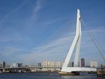
The Magere Brug is a bridge over the river Amstel in Amsterdam, Netherlands. It connects the banks of the river at Kerkstraat, between the Keizersgracht and Prinsengracht.

<span class="mw-page-title-main">Rhine–Meuse–Scheldt delta</span> Delta formed by 3 rivers in the Netherlands

The Rhine–Meuse–Scheldt delta is a river delta in the Netherlands formed by the confluence of the Rhine, the Meuse and the Scheldt rivers. In some cases, the Scheldt delta is considered a separate delta to the Rhine–Meuse delta. The result is a multitude of islands, branches and branch names that may at first sight look bewildering, especially as a waterway that appears to be one continuous stream may change names as many as seven times, e.g. Rhine → Bijlands Kanaal → Pannerdens Kanaal → Nederrijn → Lek → Nieuwe Maas → Het Scheur → Nieuwe Waterweg. Since the Rhine contributes most of the water, the shorter term Rhine Delta is commonly used. However, this name is also used for the delta where the Alpine Rhine flows into Lake Constance, so it is clearer to call the larger one Rhine–Meuse delta, or even Rhine–Meuse–Scheldt delta, as the Scheldt ends in the same delta. By some calculations, the delta covers 25,347 km2 (9,787 sq mi), making it the largest in Europe.

<span class="mw-page-title-main">Waalbrug</span> Bridge in Nijmegen, Netherlands

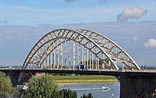
The Waalbrug is an arch bridge over the Waal River in Nijmegen, Gelderland, the Netherlands. The full length of the Waalbrug is 604 metres (1,982 ft), the middle of the arch being about 65 metres (213 ft) high. The arch itself is 244.1 metres (801 ft) long and was the longest arch in Europe at the time of construction.

Van Bruggen is a Dutch toponymic surname translating to "from/of [the] bridge[s]". Variant names with the same origin are Ter Brugge(n), Ter Brugghen, Van de(r) Brug, Van der Brugge(n), Van der Brugghen, and Verbrugge(n). Different settlements and houses with the name (de) Brug(ge) could also be at the source of each family name. People with these surnames include:

<span class="mw-page-title-main">Maas–Waal Canal</span>

The Maas–Waal Canal is a canal in the Netherlands that connects the river Meuse to the river Waal. The channel is about 13.5 kilometres (8.4 mi) long and runs from Weurt to the south and ends at Heumen. The connection of the Meuse and the Maas–Waal Canal is the tripoint between the provinces of Gelderland, Limburg and North Brabant.

<span class="mw-page-title-main">Battle of Nijmegen</span> 1944 battle in the Netherlands during WWII

The Battle of Nijmegen, also known as the Liberation of Nijmegen, occurred from 17 to 20 September 1944, as part of Operation Market Garden during World War II.

<span class="mw-page-title-main">Vlotbrug</span> Special type of bridges at the Great North Holland Canal

Vlotbrug translates from Dutch into English as "raft bridge". It is a special kind of floating Retractable bridges at the Great North Holland Canal which pivot either centrally or from one or both banks of a body of water to allow vessels to pass through.

<span class="mw-page-title-main">Hedel Bridge</span> Bridge in Hedel, Netherlands

Hedel Bridge is a tied-arch bridge over the Meuse dating from 1937 near Hedel, Gelderland. The bridge was built for the Oude Rijksweg, a former part of the A2 motorway that connected 's-Hertogenbosch to Utrecht.