List of bridges in Zambia

Last updated

Contents

Historical or architectural interest bridges

NameDistinctionLengthTypeCarries
Crosses
OpenedLocationProvinceRef.
1 Kariba Dam Suspension Bridge
dismantled
Temporary bridge used for the construction of the Kariba Dam
Span : 424 m (1,391 ft)
219 m (719 ft) Suspension
Towerless, steel truss deck
Road bridge
Zambezi
1958 Siavonga Kariba
16°31′17.5″S28°45′45.6″E / 16.521528°S 28.762667°E / -16.521528; 28.762667 (Kariba Dam Suspension Bridge)
Southern Province
Flag of Zimbabwe.svg  Zimbabwe
[1]
Chinyingi Bridge, northern Zambia.jpg 2 Chinyingi Suspension Bridge 300 m (980 ft) Suspension
Steel
Footbridge
Zambezi
1977 Chinyingi
13°21′10.5″S23°00′44.8″E / 13.352917°S 23.012444°E / -13.352917; 23.012444 (Chinyingi Suspension Bridge)
North-Western Province [2]

Major bridges

NameSpanLengthTypeCarries
Crosses
OpenedLocationProvinceRef.
Olto Beit Bridge over the Zambesi at Chirundu. North Rhodesia (37788904851).jpg 1 Otto Beit Bridge 328 m (1,076 ft)369 m (1,211 ft) Suspension
Steel truss deck, steel pylons
1939 Chirundu, Zambia Chirundu, Zimbabwe
16°02′16.6″S28°51′08.2″E / 16.037944°S 28.852278°E / -16.037944; 28.852278 (Otto Beit Bridge)
Southern Province
Flag of Zimbabwe.svg  Zimbabwe
[S 1]
Luangwa bridge (8546780863)2.jpg 2 Luangwa Bridge 222 m (728 ft)302 m (991 ft) Cable-stayed
Composite steel/concrete deck, steel pylons
40+222+40
1968 Chongwe District Petauke District
14°58′33.1″S30°12′43.6″E / 14.975861°S 30.212111°E / -14.975861; 30.212111 (Luangwa Bridge)
Lusaka Province
Eastern Province
[S 2]
[3]
The bridges at Chirundu border post.jpg 3 Second Chirundu Bridge 160 m (520 ft)400 m (1,300 ft) Box girder
Prestressed concrete
119+160+119
2002 Chirundu, Zambia Chirundu, Zimbabwe
16°02′18.8″S28°51′05.8″E / 16.038556°S 28.851611°E / -16.038556; 28.851611 (Second Chirundu Bridge)
Southern Province
Flag of Zimbabwe.svg  Zimbabwe
[S 3]
[4]
Victoria Falls Bridge, Zambia.jpg 4 Victoria Falls Bridge 156 m (512 ft)198 m (650 ft) Arch
Steel deck arch
1905 Victoria Falls Livingstone
17°55′42.2″S25°51′25.3″E / 17.928389°S 25.857028°E / -17.928389; 25.857028 (Victoria Falls Bridge)
Southern Province
Flag of Zimbabwe.svg  Zimbabwe
[S 4]
[5]
[6]
Zambezi Bridge construction at Kazungula.jpg 5 Kazungula Bridge 129 m (423 ft)(x5)923 m (3,028 ft) Extradosed
Concrete box girder deck, 6 concrete pylons
54+85+5x129+85+54
2020 Kazungula Kasane
17°47′28.4″S25°15′45.0″E / 17.791222°S 25.262500°E / -17.791222; 25.262500 (Kazungula Bridge)
Southern Province
Flag of Botswana.svg  Botswana
[S 5]
[7]
[8]
Katima Mulilo Bridge.jpg 6 Katima Mulilo Bridge 900 m (3,000 ft) Box girder
Prestressed concrete
2004 Sesheke Katima Mulilo
17°28′18.9″S24°14′58.5″E / 17.471917°S 24.249583°E / -17.471917; 24.249583 (Katima Mulilo Bridge)
Western Province
Flag of Namibia.svg  Namibia
[S 6]

See also

Map all coordinates using: OpenStreetMap  
Download coordinates as: KML
GPX (primary)
GPX (secondary)
GPX (all)

Related Research Articles

This article is about the transport in Zambia.

<span class="mw-page-title-main">Zambezi</span> Major river in southern Africa

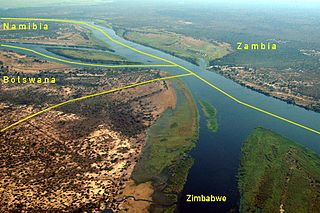
The Zambezi River is the fourth-longest river in Africa, the longest east-flowing river in Africa and the largest flowing into the Indian Ocean from Africa. Its drainage basin covers 1,390,000 km2 (540,000 sq mi), slightly less than half of the Nile's. The 2,574-kilometre-long (1,599 mi) river rises in Zambia and flows through eastern Angola, along the north-eastern border of Namibia and the northern border of Botswana, then along the border between Zambia and Zimbabwe to Mozambique, where it crosses the country to empty into the Indian Ocean.

<span class="mw-page-title-main">Victoria Falls Bridge</span> Transnational bridge connecting Zambia and Zimbabwe

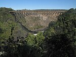
The Victoria Falls Bridge crosses the Zambezi River just below the Victoria Falls and is built over the Second Gorge of the falls. As the river forms the border between Zimbabwe and Zambia, the bridge links the two countries and has border posts on the approaches to both ends, at the towns of Victoria Falls, Zimbabwe, and Livingstone, Zambia.

<span class="mw-page-title-main">Livingstone, Zambia</span> Place in Southern Province, Zambia

Livingstone is a city in Zambia. Until 1935, it served as the capital city of Zambia. Lying 10 km (6.2 mi) to the north of the Zambezi River, it is a tourism attraction center for the Victoria Falls and a border town with road and rail connections to Zimbabwe on the other side of the Victoria Falls. A historic British colonial city, its present population was enumerated at 134,349 inhabitants at the 2010 census. It is named after David Livingstone, the Scottish explorer and missionary who was the first European to explore the area.

<span class="mw-page-title-main">Kazungula</span> Human settlement in Zambia

Kazungula is a small border town in Zambia, lying on the north bank of the Zambezi River about 70 kilometres (45 mi) west of Livingstone on the M10 Road.

<span class="mw-page-title-main">Kasane</span> Place in Chobe District, Botswana

Kasane is a town in Botswana, close to Africa's 'Four Corners', where four countries almost meet: Botswana, Namibia, Zambia and Zimbabwe. It is at the far north-eastern corner of Botswana where it serves as the administrative center of the Chobe District. The population of Kasane was 9,244 in 2011 census.

<span class="mw-page-title-main">Southern Province, Zambia</span> Province of Zambia

Southern Province is one of Zambia's ten provinces, and home to Zambia's premier tourist attraction, Mosi-oa-Tunya, shared with Zimbabwe. The centre of the province, the Southern Plateau, has the largest area of commercial farmland of any Zambian province, and produces most of the maize crop.

<span class="mw-page-title-main">Chirundu Bridge</span> Bridge in Zimbabwe, crossing the Zimbabwe-Zambia border

The Chirundu Bridge now consists of two road bridges side by side across the Zambezi River between the small town of Chirundu, Zambia and the village of Chirundu, Zimbabwe. At this location around 65 km downstream from the Kariba Dam the river is about 400 m wide. The bridges carry the Harare to Lusaka section of the Great North Road, which extends between South Africa and East Africa, and was once seen as part of a Cape to Cairo Road.

<span class="mw-page-title-main">Kazungula Ferry</span>

The Kazungula Ferry was a pontoon ferry across the 400-metre-wide (1,300 ft) Zambezi River between Botswana and Zambia. It was one of the largest ferries in south-central Africa, having a capacity of 70 tonnes. The service was provided by two motorised pontoons and operated between border posts at Kazungula, Zambia and Kazungula, Botswana.

<span class="mw-page-title-main">Lusaka–Livingstone Road</span> Road in Zambia

The T1 or Lusaka–Livingstone Road is the main highway of the Southern Province of Zambia. It begins 55 kilometres south of the city of Lusaka and heads south-west to the principal tourist destination, Victoria Falls in Livingstone, Southern Africa, measuring approximately 430 kilometres (267 mi). The entire route is part of Trans-African Highway network number 4 or Cairo-Cape Town Highway between Cairo and Cape Town.

<span class="mw-page-title-main">Outline of Zambia</span> Overview of and topical guide to Zambia

The following outline is provided as an overview of and topical guide to Zambia:

Zambia, officially known as the Republic of Zambia, is a landlocked country in Southern Africa. The neighbouring countries are the Democratic Republic of the Congo to the north, Tanzania to the north-east, Malawi to the east, Mozambique, Zimbabwe, Botswana, and Namibia to the south, and Angola to the west. The capital city is Lusaka, located in the southeast of the country. The population is concentrated mainly around the capital and the Copperbelt to the northwest.

<span class="mw-page-title-main">Livingstone District</span> District in Southern Province, Zambia

Livingstone District is a district of Zambia, located in Southern Province. The capital lies at Livingstone, Zambia. As of the 2000 Zambian Census, the district had a population of 103,288 people. Its border with Zimbabwe is formed by the Zambezi River and Victoria Falls. Although most people live in Livingstone, other villages include Jinga Jinga in the north and Simonga in the southwest.

<span class="mw-page-title-main">Visa policy of Zimbabwe</span> Policy on permits required to enter Zimbabwe

Visitors to Zimbabwe must obtain a visa from one of the Zimbabwean diplomatic missions or online unless they come from one of the visa exempt countries or are eligible for visa on arrival. As of November 2014 Zimbabwe and Zambia also offer a universal tourist visa.

<span class="mw-page-title-main">Kazungula Bridge</span> International crossing of the Zambezi River

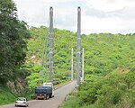
Kazungula Bridge is a road and rail bridge over the Zambezi River between the countries of Zambia and Botswana at the town of Kazungula. The 923-metre-long (3,028 ft) by 18.5-metre-wide (61 ft) bridge has a longest span of 129 metres (423 ft) and links the town of Kazungula in Zambia with Botswana. The bridge features a single-line railway track between two traffic lanes and walkways for pedestrians.

The A8 Highway is a paved primary trunk road in Zimbabwe running from Bulawayo to Victoria Falls. It is managed by the Zimbabwe National Roads Administration (ZINARA). It is part of the R9 Route, which links Victoria Falls with Beitbridge.

The M10 Road is a Road in Zambia. It goes from Livingstone, through Sesheke, to Mongu. The Road is approximately 508 kilometres and follows the Zambezi River for its entire length.

References

  1. "Otto Beit Bridge".
  2. "Luangwa Bridge".
  3. "Chirundu Bridge".
  4. "Victoria Falls Bridge".
  5. "Kazungula Bridge".
  6. "Katima Mulilo Bridge".
  1. Thompson, F.B. (April 1960). "The road suspension bridge at Kariba". Civil Engineering. South African Institution Of Civil Engineering (SAICE). 2 (4): 57–65. hdl:10520/AJA10212019_15943. ISSN   1021-2000.
  2. McIntyre, Chris (2011) [1996]. "Chinyingi Suspension Bridge". In Bradt Travel Guides (ed.). Zambia. p. 507. ISBN   978-1-84162-373-3.
  3. Data collection survey on transport and infrastructure development along Nacala Corridor - final report (PDF). Openjicareport.jica.go.jp (Report). Republic of Zambia - Road Development Agency (RDA) - Japan International Cooperation Agency. March 2019. Retrieved March 19, 2023.
  4. Yamazaki, Keiji; Kashiwamura, Tomohiko; Otsubo, Masato; Yamazaki, Jun. "Chirundu Bridge Construction Project in Zambia/Zimbabwe". The Importance of Design and Technical Management in International Bridge (PDF). Ssms.jp. Archived from the original (PDF) on 3 January 2020.
  5. "Victoria Falls Bridge". Asce.org - American Society of Civil Engineers. Archived from the original on 23 April 2021.
  6. Roberts, Peter (2011). "Sun, Steel & Spray - A history of the Victoria Falls Bridge". Zambezibookcompany.com. Retrieved 2 December 2022.
  7. Frémont, Guy; Yi Wu, Ze; Lavigne, Thomas (March 2011). Science et Industrie S.A (ed.). "Le pont multi-haubané de Kazungula sur le Zambèze" [The Kazungula multiple-cable-stayed bridge over the Zambezi](PDF). Revue Travaux (in French). Fédération nationale des travaux publics (FNTP). 879: 115–121. ISSN   0041-1906.
  8. "US$259m Kazungula Bridge linking Botswana and Zambia launched". Constructafrica.com. Retrieved March 19, 2023.

Further reading