Related Research Articles

U.S. Route 101, or U.S. Highway 101 (US 101), is a north–south United States Numbered Highway that traverses the states of California, Oregon, and Washington on the West Coast of the United States. It travels for over 1,500 miles (2,400 km), primarily along the Pacific Ocean, and is also known by various names, including El Camino Real in parts of California, the Oregon Coast Highway, and the Olympic Highway in Washington. Despite its three-digit number, normally used for spur routes, US 101 is classified as a major route in the United States Numbered Highway System.

The Historic Columbia River Highway is an approximately 75-mile-long (121 km) scenic highway in the U.S. state of Oregon between Troutdale and The Dalles, built through the Columbia River Gorge between 1913 and 1922. As the first planned scenic roadway in the United States, it has been recognized in numerous ways, including being listed on the National Register of Historic Places, being designated as a National Historic Landmark by the U.S. Secretary of the Interior, being designated as a National Historic Civil Engineering Landmark by the American Society of Civil Engineers, and being considered a "destination unto itself" as an All-American Road by the U.S. Secretary of Transportation. The historic roadway was bypassed by the present Columbia River Highway No. 2 from the 1930s to the 1950s, leaving behind the old two-lane road. The road is now mostly owned and maintained by the state through the Oregon Department of Transportation as the Historic Columbia River Highway No. 100 or the Oregon Parks and Recreation Department as the Historic Columbia River Highway State Trail.

U.S. Route 199 (US 199) is a U.S. Highway in the states of California and Oregon. The highway was established in 1926 as a spur of US 99, which has since been replaced by Interstate 5 (I-5). US 199 stretches 80 miles (130 km) from US 101 near Crescent City, California northeast to I-5 in Grants Pass, Oregon. The highway is the northern portion of the Redwood Highway. In Oregon, US 199 is officially known as Redwood Highway No. 25. The majority of the road in California is the Smith River Scenic Byway, a National Forest Scenic Byway. The first roadway, a plank road, from Crescent City was established in May 1858, and before the US 199 designation was applied to the highway, the roadway was designated Highway 25 and Route 1.
The Oregon Department of Transportation (ODOT) is a department of the state government of the U.S. state of Oregon responsible for systems of transportation. It was first established in 1969. It had been preceded by the Oregon State Highway Department which, along with the Oregon State Highway Commission, was created by an act of the Oregon Legislative Assembly in 1913. It works closely with the five-member Oregon Transportation Commission in managing the state's transportation systems.

The Astoria–Megler Bridge is a steel cantilever through-truss bridge in the Pacific Northwest region of the United States that spans the lower Columbia River. It carries a section of U.S. Route 101 from Astoria, Oregon, to Point Ellice near Megler, Washington. Opened in 1966, it is the longest continuous truss bridge in North America.
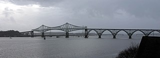
The Conde B. McCullough Memorial Bridge, is a cantilever bridge that spans the Coos Bay on U.S. Route 101 near North Bend, Oregon. When completed in 1936 it was named the North Bend Bridge. In 1947 it was renamed in honor of Conde B. McCullough who died May 5, 1946. This and 10 other major bridges on the Oregon Coast Highway were designed under his supervision.

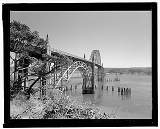
The Yaquina Bay Bridge is an arch bridge that spans Yaquina Bay south of Newport, Oregon. It is one of the most recognizable of the U.S. Route 101 bridges designed by Conde McCullough and one of eleven major bridges on the Oregon Coast Highway designed by him. It superseded the last ferry crossing on the highway.

The Umpqua River Bridge is a swing-span bridge that spans the Umpqua River in Reedsport, Oregon. It consists of a central swing span flanked by two reinforced concrete arches on each end. The swing span was necessary to accommodate tall sailing vessels which were common on the Umpqua River. The final cost of the bridge was $510,500.

Conde Balcom McCullough was an American civil engineer who is primarily known for designing many of Oregon's coastal bridges on U.S. Route 101. The native of South Dakota worked for the Oregon Department of Transportation from 1919 to 1935 and 1937 until he died in 1946. McCullough also was a professor at Oregon State University.
U.S. Route 101 (US 101), is a major north–south U.S. Highway in Oregon that runs through the state along the western Oregon coastline near the Pacific Ocean. It runs from the California border, south of Brookings, to the Washington state line on the Columbia River, between Astoria, Oregon, and Megler, Washington.

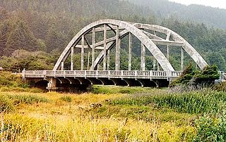
Cape Creek Bridge is an arch bridge that spans Cape Creek in Lane County, Oregon, United States. The bridge carries U.S. Route 101. Opened in 1932, it was designed by noted bridge engineer Conde McCullough and built of reinforced concrete by John K. Holt. The total length of the bridge is 619 feet (189 m), with a main span of 220 feet (67 m). The bridge resembles a Roman aqueduct, with a single parabolic arch that spans half its length. It was listed as Cape Creek Bridge No. 01113 on the National Register of Historic Places in 2005, as part of the C. B. McCullough Major Oregon Coast Highway Bridges MPS.

Oregon Route 58, also known as the Willamette Highway No. 18, is a state highway in the U.S. state of Oregon. The route, signed east–west, runs in a southeast–northwest direction, connecting U.S. Route 97 north of Chemult with Interstate 5 south of Eugene. It links the Willamette Valley and Central Oregon, crossing the Cascade Range at Willamette Pass. OR 58 is generally a modern two-lane highway with a speed limit of 55 mph (88 km/h), built through the Willamette National Forest in the 1930s.

The Isaac Lee Patterson Bridge, also known as the Rogue River Bridge and the Isaac Lee Patterson Memorial Bridge, is a concrete arch bridge that spans the Rogue River in Curry County, Oregon. The bridge was constructed by the Mercer Fraser Company of Eureka, California. The bridge carries U.S. Route 101 across the river, near the point where the river empties into the Pacific Ocean, and connects the towns of Gold Beach and Wedderburn. A bridge with strong Art Deco influences, the Isaac Lee Patterson Bridge is a prominent example of the designs of the Oregon bridge designer and highway engineer Conde McCullough. It was designated a National Historic Civil Engineering Landmark by the American Society of Civil Engineers in 1982. It is part of a series of notable bridges designed by McCullough for the Oregon Coast Highway in the 1930s. It was placed on the National Register of Historic Places in 2005.

U.S. Route 26 (US 26) is a major cross-state United States Numbered Highway with its western terminus in the U.S. state of Oregon, connecting US 101 on the Oregon Coast near Seaside with the Idaho state line east of Nyssa. Local highway names include the Sunset Highway No. 47, Mount Hood Highway No. 26, and John Day Highway No. 5 before continuing into Idaho and beyond.

The Ellsworth Street Bridge is a highway bridge that crosses the Willamette River in Albany, Oregon, United States. Built in 1925, the two-lane structure carries U.S. Route 20 eastbound traffic, with the adjacent Lyon Street Bridge carrying westbound traffic. The 1,090-foot-long (330 m) steel truss bridge was designed by Conde McCullough and opened in 1926.

Wilson River Bridge, also known as Wilson River Bridge at Tillamook or Wilson River Bridge No. 01499, is a bridge near Tillamook, Oregon, United States. The 1931 bridge was designed by Conde McCullough in the Classical Revival and Art Deco styles. It covers a span of 180 feet (55 m) and brings coastal U.S. Route 101 (US 101) over the Wilson River.
Ten Mile Creek Bridge is a Conde McCullough-designed bridge near Yachats in Lane County in the U.S. state of Oregon. It was listed on the National Register of Historic Places in 2005.
James Burton Norman Jr. is an American photographer, author, and cultural historian.
Tenmile Creek is a stream in Lane County, in the U.S. state of Oregon. It flows west from the Siuslaw National Forest in the Oregon Coast Range into the Pacific Ocean at Stonefield Beach State Recreation Site, about 6 miles (10 km) south of Yachats.

Rocky Creek Bridge No. 01089, also known as Ben Jones Bridge, is a concrete highway bridge spanning Rocky Creek along the Pacific Ocean coast of the U.S. state of Oregon. The bridge crosses a gorge near the creek's mouth, about 2 miles (3 km) south of Depoe Bay in Lincoln County. Built in 1927, the bridge originally carried U.S. Route 101 over the creek. After a stretch of the highway was relocated to make it straighter, the abandoned piece of the old highway became Otter Crest Loop Road, a local road west of the new highway.
References
- 1 2 Oregon Department of Transportation, Public Road Inventory Archived 2008-02-24 at the Wayback Machine , accessed April 2008
- 1 2 National Bridge Inventory, accessed 2006
- ↑ 101 Mile by Mile Guide to Thomas Creek Bridge on the Oregon Coast, accessed October 2008
- ↑ 101 Mile by Mile Guide to Rogue River Bridge on the Oregon Coast, accessed October 2008
- 1 2 3 4 5 6 7 8 9 10 11 Oregon National Register List, accessed October 2008
- ↑ Conde B. McCullough Memorial Bridge, accessed October 2008
- 1 2 3 4 5 6 7 8 9 10 11 12 13 14 15 Conde B. McCullough: Oregon's Master Bridge Builder
- ↑ Highway Tunnels of Oregon
- ↑ Oregon Coastal Highway Bridges Archived 2012-07-16 at the Wayback Machine
- Oregon Department of Transportation, Spanning Oregon's Coast, accessed April 2008