List of cities and towns in the South Island by population

Last updated

This is a list of cities and towns in the South Island of New Zealand by the population of their urban area.

Contents

The populations given in the table below are provisional New Zealand usually resident populations, June 2022 estimates, and refer to the urban area defined under the Statistical Standard for Geographic Areas 2018 (SSGA) unless otherwise stated.

Cities

Urban areaPopulationRegionTerritorial authority
Christchurch 377,900 Canterbury Christchurch City Council
Dunedin 102,400 Otago Dunedin City Council
Invercargill 49,800 Southland Invercargill City Council
Nelson 50,800 Nelson Nelson City Council

Towns

Population 10,000 and over

Urban areaPopulationRegionTerritorial authority
Ashburton 20,600 Canterbury Ashburton District
Blenheim 29,000 Marlborough Marlborough District
Kaiapoi 13,400 Canterbury Waimakariri District
Mosgiel 14,500 Otago Dunedin City
Oamaru 13,900 Otago Waitaki District
Queenstown 15,800 Otago Queenstown Lakes District
Rangiora 19,700 Canterbury Waimakariri District
Richmond 18,450 Tasman Tasman District
Rolleston 28,000 Canterbury Selwyn District
Timaru28,600 Canterbury Timaru District
Wānaka 12,150 Otago Queenstown Lakes District

† Timaru was officially a city until local government reorganisation in 1989, and is still frequently referred to as such.

Population 1,000 to 9,999

Urban areaPopulationRegionTerritorial authority
Alexandra 6,090 Otago Central Otago District
Amberley 2,340 Canterbury Hurunui District
Arrowtown 2,950 Otago Queenstown Lakes District
Arthurs Point 1,360 Otago Queenstown Lakes District
Balclutha 4,300 Otago Clutha District
Bluff 1,830 Southland Invercargill City
Brighton 1,520 Otago Dunedin City
Brightwater 2,340 Tasman Tasman District
Clyde 1,270 Otago Central Otago District
Cromwell 7,010 Otago Central Otago District
Darfield 3,120 Canterbury Selwyn District
Diamond Harbour 1,600 Canterbury Christchurch City
Geraldine 2,820 Canterbury Timaru District
Gore 8,220 Southland Gore District
Greymouth 8,320 West Coast Grey District
Hokitika 2,860 West Coast Westland District
Hope 990 Tasman Tasman District
Kaikōura 2,330 Canterbury Kaikoura District
Lake Hāwea 1,860 Otago Queenstown Lakes District
Lake Hayes 6,760 Otago Queenstown Lakes District
Leeston 2,490 Canterbury Selwyn District
Lincoln 9,180 Canterbury Selwyn District
Lyttelton 3,150 Canterbury Christchurch City
Māpua 1,350 Tasman Tasman District
Mataura 1,720 Southland Gore District
Methven 1,970 Canterbury Ashburton District
Milton 2,200 Otago Clutha District
Motueka 8,340 Tasman Tasman District
Oxford 2,440 Canterbury Waimakariri District
Pegasus 3,820 Canterbury Waimakariri District
Picton 4,800 Marlborough Marlborough District
Pleasant Point 1,490 Canterbury Timaru District
Prebbleton 5,260 Canterbury Selwyn District
Rakaia 1,560 Canterbury Ashburton District
Reefton 930 West Coast Buller District
Renwick 2,620 Marlborough Marlborough District
Riverton / Aparima 1,660 Southland Southland District
Runanga 1,240 West Coast Grey District
Tākaka 1,400 Tasman Tasman District
Te Anau 2,970 Southland Southland District
Temuka 4,660 Canterbury Timaru District
Twizel 1,670 Canterbury MacKenzie District
Wakefield 2,680 Tasman Tasman District
Waikouaiti 1,240 Otago Dunedin City
Waimate 3,600 Canterbury Waimate District
West Melton 2,640 Canterbury Selwyn District
Westport 4,290 West Coast Buller District
Winton 2,450 Southland Southland District
Woodend 3,210 Canterbury Waimakariri District

Major suburbs

The following suburbs have a population of over 2,000.

Christchurch

SuburbPopulationRegionTerritorial authority
Riccarton 9,786 Canterbury Christchurch City Council
Linwood 9,024 Canterbury Christchurch City Council
Hornby 8,007 Canterbury Christchurch City Council
Christchurch Central City 7,653 Canterbury Christchurch City Council
Shirley 7,176 Canterbury Christchurch City Council
Cashmere 6,876 Canterbury Christchurch City Council
Woolston 5,733 Canterbury Christchurch City Council
Sydenham 5,478 Canterbury Christchurch City Council
Halswell 4,065 Canterbury Christchurch City Council
Sumner 3,978 Canterbury Christchurch City Council
Belfast 3,726 Canterbury Christchurch City Council
New Brighton 3,642 Canterbury Christchurch City Council
Papanui 3,543 Canterbury Christchurch City Council
Merivale 3,012 Canterbury Christchurch City Council
Fendalton 2,898 Canterbury Christchurch City Council
Bishopdale 2,454 Canterbury Christchurch City Council
Burnside 2,370 Canterbury Christchurch City Council

Dunedin

SuburbPopulationRegionTerritorial authority
Mosgiel10,497 Otago Dunedin City Council
Dunedin North 7,047 Otago Dunedin City Council
St Kilda 5,904 Otago Dunedin City Council
Caversham 5,058 Otago Dunedin City Council
North East Valley 4,413 Otago Dunedin City Council
St Clair 4,179 Otago Dunedin City Council
Roslyn 3,957 Otago Dunedin City Council
Vauxhall 3,918 Otago Dunedin City Council
Brockville 3,393 Otago Dunedin City Council
Mornington 3,393 Otago Dunedin City Council
Wakari 3,069 Otago Dunedin City Council
Port Chalmers~3,000 Otago Dunedin City Council
Musselburgh 2,835 Otago Dunedin City Council
South Dunedin 2,538 Otago Dunedin City Council
Andersons Bay 2,532 Otago Dunedin City Council
Green Island2,430 Otago Dunedin City Council
City Rise 2,406 Otago Dunedin City Council
Pine Hill 2,259 Otago Dunedin City Council
Fairfield 2,010 Otago Dunedin City Council

‡ Mosgiel, Port Chalmers, and Green Island were officially separate towns until local government reorganisation in 1989, and are separated from Dunedin's main urban area. They are still frequently referred to as towns.

Invercargill

SuburbPopulationRegionTerritorial authority
Rosedale 3,855 Southland Invercargill City Council
Gladstone-Avenal 3,768 Southland Invercargill City Council
Grasmere 3,342 Southland Invercargill City Council
Heidelberg 3,078 Southland Invercargill City Council
Newfield 2,910 Southland Invercargill City Council
Georgetown 2,229 Southland Invercargill City Council
Waikiwi 2,193 Southland Invercargill City Council

Nelson

SuburbPopulationRegionTerritorial authority
Stoke ~7,000 Nelson Nelson City Council
The Wood 2,730 Nelson Nelson City Council
Maitlands 2,412 Nelson Nelson City Council
Atawhai 2,154 Nelson Nelson City Council
Tāhunanui ~2,000 Nelson Nelson City Council
Annesbrook Nelson Nelson City Council
Britannia Heights Nelson Nelson City Council
Nelson South Nelson Nelson City Council
Washington Valley Nelson Nelson City Council

Others

SuburbPopulationTownTerritorial authority
Allenton 5,172 Ashburton Ashburton District Council
Redwoodtown 4,881 Blenheim Marlborough District Council
Whitney 4,005 Blenheim Marlborough District Council
Witherlea 3,993 Blenheim Marlborough District Council
Marchwiel 3,741 Timaru Timaru District Council
Highfield 3,408 Timaru Timaru District Council
Springlands 3,081 Blenheim Marlborough District Council
West End2,790 Timaru Timaru District Council
Tinwald 2,703 Ashburton Ashburton District Council
Mayfield 2,694 Blenheim Marlborough District Council
Seaview 2,505 Timaru Timaru District Council
Parkside 2,412 Timaru Timaru District Council
Hampstead 2,325 Ashburton Ashburton District Council
Watlington 2,256 Timaru Timaru District Council
Gleniti 2,022 Timaru Timaru District Council

Map

See also

Related Research Articles

<span class="mw-page-title-main">Borough</span> Administrative division in some English-speaking countries

A borough is an administrative division in various English-speaking countries. In principle, the term borough designates a self-governing walled town, although in practice, official use of the term varies widely.

<span class="mw-page-title-main">South Island</span> One of the two main New Zealand islands

The South Island, also officially named Te Waipounamu, is the larger of the two major islands of New Zealand in surface area, the other being the smaller but more populous North Island. It is bordered to the north by Cook Strait, to the west by the Tasman Sea, and to the south and east by the Pacific Ocean. The South Island covers 150,437 square kilometres (58,084 sq mi), making it the world's 12th-largest island. At low altitude, it has an oceanic climate.

<span class="mw-page-title-main">Oamaru</span> Town in Otago, New Zealand

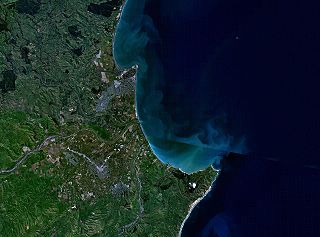
Oamaru is the largest town in North Otago, in the South Island of New Zealand, it is the main town in the Waitaki District. It is 80 kilometres (50 mi) south of Timaru and 120 kilometres (75 mi) north of Dunedin on the Pacific coast; State Highway 1 and the railway Main South Line connect it to both cities. With a population of 13,900, Oamaru is the 28th largest urban area in New Zealand, and the third largest in Otago behind Dunedin and Queenstown. The town is the seat of Waitaki District, which includes the surrounding towns of Kurow, Weston, Palmerston, and Hampden. which combined have a total population of 23,200.

<span class="mw-page-title-main">Territorial authorities of New Zealand</span> Second tier of local government

Territorial authorities are the second tier of local government in New Zealand, below regional councils. There are 67 territorial authorities: 13 city councils, 53 district councils and the Chatham Islands Council. District councils serve a combination of rural and urban communities, while city councils administer the larger urban areas. Five territorial authorities also perform the functions of a regional council and thus are unitary authorities. The Chatham Islands Council is a sui generis territorial authority that is similar to a unitary authority.

<span class="mw-page-title-main">Timaru</span> City in Canterbury, New Zealand

Timaru is a port city in the southern Canterbury Region of New Zealand, located 157 km (98 mi) southwest of Christchurch and about 196 km (122 mi) northeast of Dunedin on the eastern Pacific coast of the South Island. The Timaru urban area is home to 28,600 people, and is the largest urban area in South Canterbury, and the second largest in the Canterbury Region overall, after Christchurch. The town is the seat of the Timaru District, which includes the surrounding rural area and the towns of Geraldine, Pleasant Point and Temuka, which combined have a total population of 48,500.

<span class="mw-page-title-main">Dunedin</span> City in Otago, New Zealand

Dunedin is the second-largest city in the South Island of New Zealand, and the principal city of the Otago region. Its name comes from Dùn Èideann, the Scottish Gaelic name for Edinburgh, the capital of Scotland. The city has a rich Scottish, Chinese and Māori heritage.

South Otago lies in the south east of the South Island of New Zealand. As the name suggests, it forms the southernmost part of the geographical region of Otago.

<span class="mw-page-title-main">Temuka</span> Town in Canterbury, New Zealand

Temuka is a town on New Zealand's Canterbury Plains, 15 kilometres north of Timaru and 142 km south of Christchurch. It is located at the centre of a rich sheep and dairy farming region, for which it is a service town. It lies on the north bank of the Temuka River, just above its confluence with the Opihi River.

Dunedin is a city of 130,400 people in the South Island of New Zealand. The principal suburbs of Dunedin are as follows. Inner and outer suburbs are ordered by location, clockwise from the city centre, starting due north:

<span class="mw-page-title-main">Clutha District</span> Territorial authority district in Otago, New Zealand

Clutha District is a local government district of southern New Zealand, with its headquarters in the Otago town of Balclutha. Clutha District has a land area of 6,334.47 km2 (2,445.75 sq mi) and an estimated population of 18,650 as of June 2022. Clutha District occupies the majority of the geographical area known as South Otago.

<span class="mw-page-title-main">Napier-Hastings Urban Area</span> Urban area in Hawkes Bay, New Zealand

The Napier-Hastings Urban Area was defined by Statistics New Zealand as a main urban area of New Zealand that was based around the twin cities of Napier and Hastings in the Hawke's Bay Region. It was defined under the New Zealand Standard Areas Classification 1992 (NZSAC92), which has since been superseded by the Statistical Standard for Geographic Areas 2018 (SSGA18).

<span class="mw-page-title-main">State Highway 1 (New Zealand)</span> Road in New Zealand

State Highway 1 is the longest and most significant road in the New Zealand road network, running the length of both main islands. It appears on road maps as SH 1 and on road signs as a white number 1 on a red shield, but it has the official designations SH 1N in the North Island, SH 1S in the South Island.

<span class="mw-page-title-main">Ritchies Transport</span>

Ritchies Transport is a New Zealand private bus operator, owned by KKR. It was established in 1972 and describes itself as "the largest privately owned bus and coach transport operator in New Zealand" with a fleet of over 1500 vehicles spread across depots nationwide. It owns a 46% stake in InterCity.

<span class="mw-page-title-main">Public transport in New Zealand</span>

Public transport in New Zealand exists in many of the country's urban areas, and takes a number of forms. Bus transport is the main form of public transport. Two major cities, Auckland and Wellington, also have suburban rail systems that have been gaining more patronage and new investment in recent years. Some cities also operate local ferry services. There are no rapid transit metros and no remaining tram systems active anywhere in New Zealand, though trams once had a major role in New Zealand's public transport.

<span class="mw-page-title-main">Caversham, New Zealand</span> Suburb in Dunedin, New Zealand

Caversham is one of the older suburbs of the city of Dunedin, in New Zealand's South Island. It is sited at the western edge of the city's central plain at the mouth of the steep Caversham Valley, which rises to the saddle of Lookout Point. Major road and rail routes south lie nearby; the South Island Main Trunk railway runs through the suburb, and a bypass skirts its main retail area, connecting Dunedin's one-way street system with the Dunedin Southern Motorway. The suburb is linked by several bus routes to its neighbouring suburbs and central Dunedin.

<span class="mw-page-title-main">South Dunedin</span> Suburb of Dunedin, New Zealand

South Dunedin is a major inner city suburb of the New Zealand city of Dunedin. It is located, as its name suggests, 2.5 kilometres (1.6 mi) to the south of the city centre, on part of a large plain known locally simply as "The Flat". The suburb is a mix of industrial, retail, and predominantly lower-quality residential properties.

<span class="mw-page-title-main">Green Island, New Zealand</span> Suburb in Dunedin, New Zealand

Green Island is a suburb of Dunedin, New Zealand. Not an actual island, this former borough takes its name from the Green Island bush, uncleared native forest extending from the valley where the community is centred over the hills towards the coast. The name of the nearby offshore island — Green Island (Okaihe) — was used to identify the bush and, thus, also lent its name to the mainland suburb.