List of disasters in the Philippines

Last updated

This is a list of disasters in the Philippines.

Volcanic eruptions

Only the church tower remains of the Cagsawa Church, which was buried by the 1814 eruption of Mayon Volcano. Cagsawa ruins.jpg
Only the church tower remains of the Cagsawa Church, which was buried by the 1814 eruption of Mayon Volcano.
The eruption column of the modern Mount Pinatubo on June 12, 1991, three days before the climactic eruption. Pinatubo91eruption clark air base.jpg
The eruption column of the modern Mount Pinatubo on June 12, 1991, three days before the climactic eruption.
Map of Pinatubo showing nearby peaks and the evacuation zones. Pinatubo evacuation areas.gif
Map of Pinatubo showing nearby peaks and the evacuation zones.
EventDateNotes
Leonard Kniaseff c.120 AD. [1] There was a scare in 1995 but PHIVOLCS investigation at the time did not disclose any unusual activity, and no unusual activity has been reported since.
San Pablo Volcanic Field 1350 AD +/- 100Last activity was the formation of Sampaloc Lake around 1350 AD +/- 100 years determined by anthropology [2]
Taal eruption 1572 to 2022Currently on eruption since January 12, 2020. Eruptions have also destroyed numerous lakeside towns, burying them with volcanic ash or submerged them by rising lake waters displaced by the erupted material. The towns of Lipa, Taal, Sala, Bauan and Tanauan were formerly located along Taal Lake. Presently, only three towns are on the lake's shore. Remnants of the old lakeside towns are reported to be seen under the lake's waters. [3]
Mayon eruption 1616 to 2018The most destructive eruption of Mayon occurred on February 1, 1814 (VEI=4). Lava flowed but not as much compared to the 1766 eruption; Instead, the volcano was belching dark ash and eventually bombarded the town of Cagsawa with tephra that buried it. Trees were burned; rivers were certainly damaged. Proximate areas were also devastated by the eruption, with ash accumulating to 9 m (30 ft) in depth. In Albay, a total of 2,200 locals perished in what is considered to be the most lethal eruption in Mayon's history; estimates by PHIVOLCS list the casualties at about 1,200, however. The eruption is believed to have contributed to the accumulation of atmospheric ash,[ citation needed ] capped by the catastrophic eruption of Mount Tambora in 1815, that led to the Year Without a Summer in 1816.
Pinatubo eruption 1500 to 2021Reawakened in 1991 producing the 2nd largest eruption in the 20th century. Followed by milder eruptions in 1992 and 1993. [4]
Mt. Kanlaon eruption 1886 to 2017The most active volcano in the Visayas, Kanlaon has erupted 26 times since 1919. Eruptions are typically phreatic explosions of small-to-moderate size that produce minor ash falls near the volcano. In 1902, the eruption was classified as strombolian, typified by the ejection of incandescent cinder, lapilli and lava bombs.
Bulusan eruption 1886 to 2022Bulusan is generally known for its sudden steam-driven or phreatic explosions. It has erupted 16 times since 1885 and is considered as the 4th most active volcano in the Philippines after Mayon, Taal, and Kanlaon. There are evacuation procedures in place for parts of the peninsula, the farms nearest the volcano are evacuated, and many of the village schools are closed if it is considered possible that a more destructive eruption could occur.
Mt. Hibok-Hibok eruption 1827, 1862, 1871 and 1948–1952On February 16, 1871, earthquakes and subterranean rumblings began to be felt in Camiguin, which increased in severity until April 30 when a volcanic fissure opened up 400 yards southwest of the village of Catarman, on the northwest flank of the Hibok-Hibok Volcano. From the opening, lava was continuously ejected and poured into the sea for four years destroying the town. At the same time, the vent started gaining in height and width thus forming Mt. Vulcan. In 1875, the Challenger expedition visited the area, and described the mountain as a dome, about 1,950 feet (590 m) in height, without any crater, but still smoking and incandescent at the top. [5]

Earthquakes

The bell tower of the Manila Cathedral after the series of destructive earthquakes of July 1880. Manila Cathedral belfry after the 1880 earthquake.jpg
The bell tower of the Manila Cathedral after the series of destructive earthquakes of July 1880.
The ruins of a church after the 2013 earthquake. Loon 2 earthquake.JPG
The ruins of a church after the 2013 earthquake.

The table below is a tally of the ten most deadly recorded earthquakes in the Philippines since the 1600s with having the most number of casualties:

Contents

18th century

19th century

Ten deadliest recorded earthquakes in the Philippines since the 1600s
MagnitudeOriginLocationDateMortalityMissingInjuredDamagesSource
17.9Tectonic Moro Gulf August 16, 1976479122889928
27.8Tectonic Luzon Island July 16, 199016211000More than 3000 10 billion
37.5Tectonic Luzon Island November 30, 1645More than 600More than 3000Unknown
47.3Tectonic Casiguran, Aurora August 2, 1968271261
57.2Tectonic Bohol & Cebu October 15, 20132228796 4 billion (est.) [8]
67.1Tectonic Mindoro November 15, 199478430 5.15 million [9]
76.7Tectonic Negros Oriental February 6, 20125162112 383 million
87.8Tectonic Panay (Lady Caycay) January 25, 194850 (est) 7 million
9UnknownTectonic Manila June 19, 166519Unknown
106.5Tectonic Laoag August 17, 19831647
117.5Tectonic Mindanao Island March 5, 200215100

Typhoon

Typhoon Yolanda or Haiyan, strongest typhoon in the Philippines. Haiyan 2013-11-07 1345Z (alternate).png
Typhoon Yolanda or Haiyan, strongest typhoon in the Philippines.
RankStormDates of impactDeaths
1 1881 Haiphong typhoon 1881, September 27–October 620,000 [10]
2 Haiyan/Yolanda 2013 2013, November 7–86,241 [11]
3 Thelma (Uring), 1991 1991, November 2–75,956 [13] [14] [15]
4 Bopha/Pablo 2012 2012, December 2–91,901
5Angela Typhoon, 18671867, September 20–261,800 [10] [16] [17]
6 Winnie 2004 2004, November 27–301,593
7 Fengshen/Frank 2008 2008, June 18–231,501 [14]
8Unidentified typhoon1897, October 7–161,500 [10] [16] [17]
9 Ike (Nitang), 1984 1984, August 31–September 41,492 [13]
10 Durian/Reming 2006 2006, November 29–December 11,399
Costliest Philippine typhoons
RankNamesDates of impactPHPUSDRef
1 Bopha, (Pablo) November 25 – December 9, 201242.2 billion1.04 billion [18]
2 Haiyan, (Yolanda) November 3 – 11, 201335.5 billion809 million [19]
3 Parma, (Pepeng) October 2 – 10, 200927.3 billion608 million [20]
4 Nesat, (Pedring) September 26 – 28, 201115 billion333 million [21]
5 Fengshen, (Frank) June 20 – 23, 200813.5 billion301 million [22]
6 Ketsana, (Ondoy) September 25 – 27, 200911 billion244 million [20]
7 Mike, (Ruping) November 10 – 14, 199010.8 billion241 million [23]
8 Angela, (Rosing) October 30 – November 4, 199510.8 billion241 million [23]
9 Flo, (Kadiang) October 2 – 6, 19938.75 billion195 million [23]
10 Megi (Juan) October 18 – 21, 20108.32 billion193 million [24]

See also

Related Research Articles

<span class="mw-page-title-main">Geography of the Philippines</span>

The Philippines is an archipelago that comprises 7,641 islands, and with a total land area of 300,000 square kilometers (115,831 sq mi), it is the world's fifth largest island country. The eleven largest islands contain 95% of the total land area. The largest of these islands is Luzon at about 105,000 square kilometers (40,541 sq mi). The next largest island is Mindanao at about 95,000 square kilometers (36,680 sq mi). The archipelago is around 800 kilometers (500 mi) from the Asian mainland and is located between Taiwan and Borneo.

<span class="mw-page-title-main">Calabarzon</span> Administrative region of the Philippines

Calabarzon, sometimes referred to as Southern Tagalog and designated as Region IV‑A, is an administrative region in the Philippines. The region comprises five provinces: Batangas, Cavite, Laguna, Quezon, and Rizal; and one highly urbanized city, Lucena. It is the most populous region in the Philippines according to the Philippine Statistics Authority (PSA), having over 16.1 million inhabitants in 2020, and is also the country's second most densely populated after the National Capital Region. It is situated southeast of Metro Manila, and is bordered by Manila Bay and South China Sea to the west, Lamon Bay and the Bicol Region to the east, Tayabas Bay and the Sibuyan Sea to the south, and Central Luzon to the north. It is home to places like Mount Makiling near Los Baños, Laguna, and Taal Volcano in Batangas.

<span class="mw-page-title-main">Mayon</span> Stratovolcano in the Philippines

Mayon, also known as Mount Mayon and Mayon Volcano, is an active stratovolcano in the province of Albay in Bicol, Philippines. A popular tourist spot, it is renowned for its "perfect cone" because of its symmetric conical shape, and is regarded as sacred in Philippine mythology.

<span class="mw-page-title-main">Mount Pinatubo</span> Active stratovolcano in the Philippines

Mount Pinatubo is an active stratovolcano in the Zambales Mountains, located on the tripoint boundary of the Philippine provinces of Zambales, Tarlac and Pampanga, all in Central Luzon on the northern island of Luzon. Its eruptive history was unknown to most before the pre-eruption volcanic activity of early 1991. Pinatubo was heavily eroded and obscured from view by dense forests which supported a population of several thousand indigenous Aetas.

<span class="mw-page-title-main">Taal Volcano</span> Volcano in the Philippines

Taal Volcano is a large caldera filled by Taal Lake in the Philippines. Located in the province of Batangas about 50 kilometers (31 mi) south of Manila, the volcano is the second most active volcano in the country with 38 recorded historical eruptions, all of which were concentrated on Volcano Island, near the middle of Taal Lake. The caldera was formed by prehistoric eruptions between 140,000 and 5,380 BP.

<span class="mw-page-title-main">Tropical Storm Thelma</span> Pacific tropical storm in 1991

Tropical Storm Thelma, known in the Philippines as Tropical Storm Uring, was one of the deadliest tropical cyclones in Philippine history, killing at least 5,081 people. Forming out of a tropical disturbance on November 1, 1991, several hundred kilometers north-northeast of Palau, the depression that would become Thelma tracked generally westward. After turning southwestward in response to a cold front, the system intensified into a tropical storm on November 4 as it approached the Philippines. Hours before moving over the Visayas, Thelma attained its peak intensity with estimated ten-minute sustained winds of 75 km/h (45 mph) and a barometric pressure of 992 mbar. Despite moving over land, the system weakened only slightly, emerging over the South China Sea on November 6 while retaining gale-force winds. Thelma ultimately succumbed to wind shear and degraded to a tropical depression. On November 8, the depression made landfall in Southern Vietnam before dissipating hours later.

The Philippines is a typhoon-prone country, with approximately 20 typhoons entering its area of responsibility each year. Locally known generally as bagyo, typhoons regularly form in the Philippine Sea and less regularly, in the South China Sea, with the months of June to September being the most active, August being the month with the most activity. Each year, at least ten typhoons are expected to hit the island nation, with five expected to be destructive and powerful. In 2013, Time declared the country as the "most exposed country in the world to tropical storms".

<span class="mw-page-title-main">Mount Bulusan</span> Volcano in the Philippines

Mount Bulusan, also known as Bulusan Volcano, is a stratovolcano on the island of Luzon in the Philippines. Located in the province of Sorsogon in the Bicol Region, it is 70 kilometres (43 mi) southeast of Mayon Volcano and approximately 390 kilometres (240 mi) southeast of Manila. Bulusan is one of the active volcanoes in the Philippines.

<span class="mw-page-title-main">Typhoon Durian</span> Pacific typhoon in 2006

Typhoon Durian, known in the Philippines as Super Typhoon Reming, was a deadly tropical cyclone that wreaked havoc in the Philippines and later crossed the Malay Peninsula in late November 2006, causing massive loss of life when mudflows from the Mayon Volcano buried many villages.

<span class="mw-page-title-main">Philippine Institute of Volcanology and Seismology</span> Government agency in the Philippines

The Philippine Institute of Volcanology and Seismology is a Philippine national institution dedicated to provide information on the activities of volcanoes, earthquakes, and tsunamis, as well as other specialized information and services primarily for the protection of life and property and in support of economic, productivity, and sustainable development. It is one of the service agencies of the Department of Science and Technology.

<span class="mw-page-title-main">National Disaster Risk Reduction and Management Council</span> Philippine government agency

The National Disaster Risk Reduction and Management Council (NDRRMC), formerly known as the National Disaster Coordinating Council (NDCC) until August 2011, is a working group of various government, non-government, civil sector and private sector organizations of the Government of the Republic of the Philippines established on June 11, 1978 by Presidential Decree 1566. It is administered by the Office of Civil Defense (OCD) under the Department of National Defense (DND). The council is responsible for ensuring the protection and welfare of the people during disasters or emergencies. The NDRRMC plans and leads the guiding activities in the field of communication, warning signals, emergency, transportation, evacuation, rescue, engineering, health and rehabilitation, public education and auxiliary services such as fire fighting and the police in the country. The Council utilizes the UN Cluster Approach in disaster management. It is the country's focal for the ASEAN Agreement on Disaster Management and Emergency Response (AADMER) and many other related international commitments.

<span class="mw-page-title-main">Quezon</span> Province in Calabarzon, Philippines

Quezon, officially the Province of Quezon, is a province in the Philippines located in the Calabarzon region on Luzon. Kalilayan was the first known name of the province upon its creation in 1591. Around the middle of the 18th century, it was changed to Tayabas. In recognition of the second president of the Philippines, Manuel L. Quezon, the name of Tayabas Province is changed to Quezon. Lucena, the provincial capital, the seat of the provincial government, and the most populous city of the province, is governed independently from the province as a highly urbanized city. To distinguish the province from Quezon City, it is sometimes called Quezon Province, a variation of the province's official name.

<span class="mw-page-title-main">1991 eruption of Mount Pinatubo</span> Volcanic eruption in the Philippines

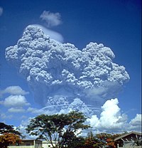
The 1991 eruption of Mount Pinatubo in the Philippines' Luzon Volcanic Arc was the second-largest volcanic eruption of the 20th century, behind only the 1912 eruption of Novarupta in Alaska. Eruptive activity began on April 2 as a series of phreatic explosions from a fissure that opened on the north side of Mount Pinatubo. Seismographs were set up and began monitoring the volcano for earthquakes. In late May, the number of seismic events under the volcano fluctuated from day-to-day. Beginning June 6, a swarm of progressively shallower earthquakes accompanied by inflationary tilt on the upper east flank of the mountain, culminated in the extrusion of a small lava dome.

<span class="mw-page-title-main">Typhoon Amy (1951)</span> Pacific typhoon in 1951

Typhoon Amy was an intense and deadly tropical cyclone that struck areas of the central Philippines in December 1951. Impacting the archipelago during the 1951 eruption of Mount Hibok-Hibok, Amy exacerbated the effects of the volcano, greatly increasing the number of resulting deaths. The fifteenth named storm and fourteenth typhoon within the western Pacific Ocean that year, Amy developed from an area of low pressure near the Kwajalein Atoll on December 3. Tracking in a general westward direction, the storm quickly intensified to reach typhoon intensity the next day. However, the typhoon's asymmetricity resulted in a fluctuation of intensity over the following few days. Afterwards, Amy intensified to reach its peak intensity with maximum sustained winds of 220 km/h (140 mph) and a minimum barometric pressure of 950 mbar on December 8. Over the ensuing two days, Amy moved over several islands in the central Philippines before emerging in the South China Sea on December 11 as the equivalent of a minimal typhoon. Shortly after, the tropical cyclone executed a tight anticyclonic loop while oscillating in strength several times before eventually weakening and dissipating on December 17, just east of Vietnam.

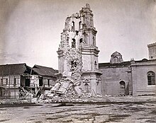
The 1880 Southern Luzon earthquakes, were one of the most destructive tremors on record in the history of the country. The shocks continued, with greater or less interruption, from July 14–25, 1880; highlighted by three violent quakes measuring Mw 7.0, Mw  7.6, and Mw  7.2 respectively. The sequence destroyed churches and other buildings, producing loss of life. Coinciding with the tectonic activity was an increase in volcanic activity in the Taal Volcano of southwestern Luzon.

<span class="mw-page-title-main">Typhoon Haiyan</span> Pacific typhoon in 2013

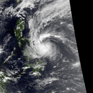
Typhoon Haiyan, known in the Philippines as Super Typhoon Yolanda, was one of the most powerful tropical cyclones ever recorded. Upon making landfall, Haiyan devastated portions of Southeast Asia, particularly the Philippines. It is one of the deadliest Philippine typhoons on record, killing at least 6,300 people in that country alone. In terms of JTWC-estimated 1-minute sustained winds, Haiyan is tied with Meranti in 2016 for being the second strongest landfalling tropical cyclone on record, only behind Goni of 2020. As of January 2014, bodies were still being found. Haiyan was also the most intense tropical cyclone worldwide in 2013.

<span class="mw-page-title-main">2017 Batangas earthquakes</span> Earthquakes in the Philippines

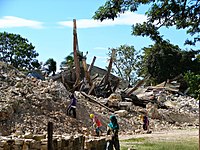
The 2017 Batangas earthquakes were an earthquake swarm that occurred from early April to mid-August 2017, affecting the province of Batangas in the Philippines and other nearby areas.

<span class="mw-page-title-main">2020–2022 Taal Volcano eruptions</span> Volcanic eruption in the Philippines

Taal Volcano in Batangas, Philippines began to erupt on January 12, 2020, when a phreatomagmatic eruption from its main crater spewed ashes over Calabarzon, Metro Manila, and some parts of Central Luzon and Ilocos Region, resulting in the suspension of school classes, work schedules, and flights in the area. The Philippine Institute of Volcanology and Seismology (PHIVOLCS) subsequently issued an Alert Level 4, indicating "that a hazardous explosive eruption is possible within hours to days." Volcanic activity continued into 2021, when smaller eruptions occurred in July 2021. On 26 March 2022, a short-lived phreatomagmatic eruption was recorded by PHIVOLCS raising the status from Alert level 2 to Alert level 3 as well as surrounding towns.

From September 20 to 26, 1867, the capital Manila of the Captaincy General of the Philippines experienced the full brunt of a storm, which was believed to be a typhoon. Dubbed as the 1867 Angela typhoon, the capital was submerged in floods from the storm. Many ships either disappeared in waters or were destroyed in the shores near Santa Lucia and Tondo, both towns near Manila Bay. The waves on the said bay were described as "mountainous" by some residents near the coast. The Spanish ship that departed from British Hong Kong named "Malaspina" sank near the Ilocos Region, killing an unknown number of passengers and crew with no survivors. The waters of the Abra River overflowed, killing over 1,800 individuals, mostly due to drowning. This would make the typhoon the fifth deadliest tropical cyclone ever to hit the present-day Philippines. No numerical estimate for the damage caused by the storm is available.

References

  1. "Leonard Range Eruption History". Global Volcanism Program. Retrieved on 2011-08-18.
  2. "San Pablo Volcanic Field Eruption History". Global Volcanism Program. Retrieved on 2011-08-18.
  3. Hargrove, Thomas (1991). "The Mysteries of Taal, a Philippine volcano and lake, her sea life and lost towns". Bookmark, Manila. ISBN   971-569-046-7.
  4. USGS. "Earthquake Information for 1990". Archived from the original on 2009-12-06. Retrieved 2010-03-06.
  5. Becker, George F. (1901). "Report on the Geology of the Philippine Islands", p.42-43. Washington Government Printing Office, 1901.
  6. Maso, Saderra (1902). Seismic and Volcanic Centers of the Philippine Archipelago. Manila: Bureau of Printing. p. 16.
  7. 1 2 Bautista, Maria Leonila P. & Bautista, Bartolome C. "Philippine Historical Earthquakes and Lessons Learned" (PDF). EqTAP Project. Archived from the original (PDF) on 2013-11-13. Retrieved 2014-06-10.
  8. "Massive extremely dangerous earthquake in Bohol, Philippines – At least 222 people killed, 8 missing, over 790 injured, around 4 billion PHP damage, 7 billion PHP reconstruction costs". Earthquake-Report.com. October 31, 2013. Retrieved June 2, 2014.
  9. "1994 Mindoro Tsunami". Philippine Institute of Volcanology and Seismology . Retrieved February 7, 2012.
  10. 1 2 3 "Tropical Cyclone Disasters in the Philippines: A Listing of Major Typhoons by Month Through 1979" Retrieved 03-27-2018.
  11. "TyphoonHaiyan - RW Updates". United Nations Office for the Coordination of Humanitarian Affairs. December 28, 2013. Philippines: Hundreds of corpses unburied after Philippine typhoon. Archived from the original on December 30, 2013. Retrieved December 30, 2013.
  12. Leoncio A. Amadore, PhD Socio-Economic Impacts of Extreme Climatic Events in the Philippines. Archived 2008-10-02 at the Wayback Machine Retrieved on 2007-02-25.
  13. 1 2 "Typhoon2000.com:THE 10 WORST TYPHOONS OF THE PHILIPPINES (A SUMMARY)". www.Typhoon2000.ph. 2004. Archived from the original on 2008-05-22. Retrieved 2018-03-27.
  14. 1 2 "Typhoon2000.com:THE 12 WORST TYPHOONS OF THE PHILIPPINES (A SUMMARY)". www.typhoon2000.ph. 2010-07-29. Retrieved 2018-03-27.
  15. "Top 25 Natural Disasters in Philippines (1901-2000)" Retrieved 03-26-2018.
  16. 1 2 Pedro Ribera, Ricardo Garcia-Herrera & Luis Gimeno (July 2008). "Historical deadly typhoons in the Philippines" (PDF). Weather. 63 (7): 196. Bibcode:2008Wthr...63..194R. doi: 10.1002/wea.275 .
  17. 1 2 "Historical deadly typhoons in the Philippines" Retrieved 03-27-2018.
  18. "Archived copy" (PDF). Archived from the original (PDF) on 2013-11-10. Retrieved 2014-06-02.{{cite web}}: CS1 maint: archived copy as title (link)
  19. Typhoon Haiyan death toll rises over 5,000 (Report). BBC. November 22, 2013. Retrieved November 22, 2013.
  20. 1 2 "Situation report no.50 on Typhoon Ondoy (Ketsana) and Typhoon Pepeng (Parma)" (PDF). Philippine National Disaster Coordinating Council. 2009-11-17. Archived from the original (PDF) on 2011-07-04. Retrieved 2010-05-14.
  21. As Typhoon Nesat departs, Philippines tallies the damage | MNN - Mother Nature Network Archived 2014-07-03 at the Wayback Machine
  22. "Archived copy" (PDF). Archived from the original (PDF) on 2008-09-09. Retrieved 2014-06-02.{{cite web}}: CS1 maint: archived copy as title (link)
  23. 1 2 3 "Destructive typhoons 1970-2003". National Disaster Coordinating Council. 2009-05-01. Archived from the original on 2004-10-28. Retrieved 2010-05-13.
  24. "Typhoon Juan Update" (PDF). NDRRMC (formerly NDCC). 2010-10-23. Archived from the original (PDF) on 2011-08-23. Retrieved 2010-10-23.