Typhoon Durian,known in the Philippines as Super Typhoon Reming,was a deadly tropical cyclone that wreaked havoc in the Philippines and later crossed the Malay Peninsula in late November 2006,causing massive loss of life when mudflows from the Mayon Volcano buried many villages.
Durian first made landfall in the Philippines,packing strong winds and heavy rains that caused mudflows near Mayon Volcano. After causing massive damage in the Philippines,it exited into the South China Sea and weakened slightly,before managing to reorganise and restrengthen into a typhoon shortly before its second landfall,this time in Vietnam near Ho Chi Minh City,causing further damage of more than US$450million. In all,Durian killed almost 2,000people,[1][2] and left hundreds more missing. Damages in the Philippines from the typhoon amounted to 5.086billion PHP (US$130million).[3]
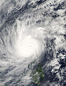
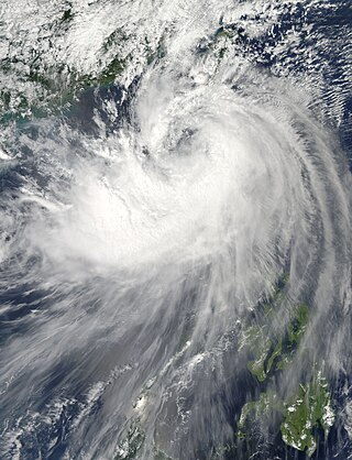
Typhoon Durian formed as a tropical depression on November24, 2006 near Chuuk State. Situated south of a ridge, the system tracked west-northwest through a region of low wind shear and good upper-level divergence.[4] Late on November26, the depression intensified into a tropical storm and was namedDurian by the Japan Meteorological Agency (JMA)[nb 1] Steady strengthening took place over the following two days as the system approached the Philippines. After attaining typhoon status on November29,[5] Durian underwent a period of rapid intensification,[4] culminating with it attaining peak 10minute maximum sustained winds of 195km/h (121mph) and a central barometric pressure of 915mbar (hPa; 27.02inHg). Durian brushed the southern coast of the Catanduanes at this intensity on November30, where a record gust of 320km/h (200mph) was observed.[5][6]
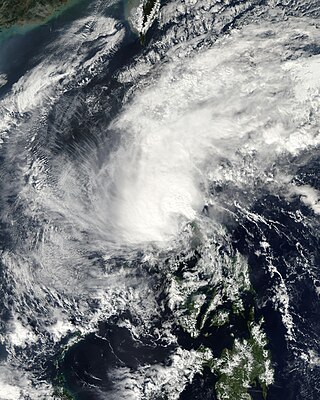
Typhoon Durian at its secondary peak intensity on December3.
Slight weakening took place before the storm made landfall in the Bicol Region.[5] Land interaction precipitated further degradation of storm, though it retained typhoon status upon emerging over the South China Sea on December1,[4] having passed just 80km (50mi) south of Metro Manila.[7] Some re-intensification occurred, with Durian reaching a secondary peak on December3. Subsequently, increasingly hostile conditions caused the system to weaken to a severe tropical storm as it turned southwest. The storm had initial intensifies before struck southern Vietnam early on December5 as a minimal typhoon before diminishing to a tropical depression.[5] The system turned westward once again and crossed the Malay Peninsula.[8] The JMA ceased tracking the storm on December6 when it crossed west of 100°E and into the North Indian Ocean basin,[5] although the Joint Typhoon Warning Center (JTWC)[nb 2] continued tracking it through the Bay of Bengal. Failing to reorganize, Durian degenerated into a remnant low on December6, before ultimately dissipating three days later off the coast of Andhra Pradesh, India, on December 9.[8]
Preparations
Philippines
Typhoon Durian on November 30, making landfall over the Philippines.
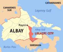
The Bicol region, where Durian first struck, is located at the southeastern portion of the Philippine island of Luzon, and is affected by an average of 8.4tropical cyclones per year.[10] Before Durian made its damaging landfall in the Philippines, the Philippine Atmospheric, Geophysical and Astronomical Services Administration (PAGASA) issued various tropical cyclone warnings and watches, including Public Storm Warning Signal #4 for Catanduanes, Albay, and both Camarines Sur and Norte provinces; this is the highest warning signal, in which winds of over 100km/h (60mph) were expected.[11][12] PAGASA turned off its weather radar in Virac to prevent damage.[11] The Philippines' National Disaster Coordinating Council issued severe weather bulletins and advisories,[13] and overall, 25provinces in the archipelago were placed on storm alert.[14] Residents in warning areas were advised of the potential for storm surge, flash flooding, and landslides.[13]
The severe threat of the typhoon prompted over 1.3million people to evacuate their homes, many of whom stayed in the 909storm shelters.[13] Officials advised residents in low-lying areas to seek higher grounds.[11] School classes in Sorsogon and in Northern and Eastern Samar were suspended,[13] and many buildings opened up as storm shelters.[11] In Naga City, about 1,500 citizens left for emergency shelters. 1,000 were evacuated elsewhere in the region,[15] including 120 in the capital city of Manila and more than 800 in Legazpi City.[14] The threat of the typhoon caused ferry, bus, and airline services to be canceled,[11] stranding thousands of people for several days.[12] All shipping traffic was halted in the Mimaropa region.[16] The Philippine Coast Guard grounded all vessels on open waters, stranding around 4,000ferry passengers in Quezon province.[14] PAGASA turned off its weather radar in Virac to prevent damage.[11]
On November30, while the typhoon was over the Philippines, the Central Committee for Flood and Storm Control and the National Committee for Search and Rescue sent telegraphs advising of the typhoon to search and rescue teams stationed along the entire coast of the country (Quảng Ninh province to Cà Mau). All provinces along the South China Sea were advised to assist an estimated 14,585vessels in the path of the storm.[17] All craft were later banned from leaving harbors.[18] Requests were also made to neighboring countries to allow Vietnamese fishermen to take refuge in their ports.[19] Strong wind warnings were disseminated to residents between Phú Yên and Bà Rịa–Vũng Tàu provinces by December2. These areas, as well as the inland provinces of Đắk Lắk, Lâm Đồng, and Bình Phước redirected all focus on the typhoon and the potential for life-threatening flash flooding.[20] Evacuation orders for southern provinces were issued by December3, with Deputy Prime MinisterNguyễn Sinh Hùng stating, "the evacuation must be completed by Monday morning [December4]."[18] Threatening an area not frequented by typhoons, many residents did not heed warnings as weather conditions ahead of the storm were calm. Approximately 6,800people in Ninh Thuận province complied with the evacuation orders; however, officials requested the assistance of the Vietnamese Army to relocate roughly 90,000people.[21] Following an unpredicted southerly shift in the storm's track towards the Mekong Delta, Hung later urged residents and officials to prepare for the storm, such that "all provinces should prepare so that we do not have another Linda."[22]
Impact
Yap
Early in its duration, Durian produced light winds on Yap in the Caroline Islands, gusting to 56km/h (35mph), as well as light rainfall totaling 52mm (2.0in). Ahead of the storm, the National Weather Service on Guam issued a tropical storm warning for various islands in Yap State.[23]
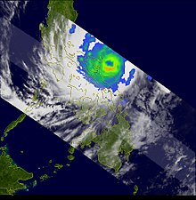
Satellite-derived rainfall totals due to Durian for the period November 24 to December 1, 2006, for the Central Philippines. Rainfall totals exceeding 200mm (~8 inches) are shown in red and extend from the western Philippine Sea across southern sections of Luzon, Catanduanes Island, and northern Samar.
Typhoon Durian affected about 3.5million people in the Philippines,[13] of whom about 120,000 were left homeless.[32] Durian damaged 588,037houses, including 228,436 that were destroyed, many of which were made out of wood.[13][33] Across the country, the storm wrecked 5,685schools, estimated at US$63.5million in damage. The Bicol Region accounted for 79% of the damaged schools, affecting around 357,400children.[34] Damage was estimated at ₱5.45billion (PHP, US$110million).[13][nb 4] As of December27, 2006, the death toll stood at 734, with 762missing.[13] The International Disaster Database listed 1,399deaths in the Philippines related to Durian,[36] making it the second deadliest natural disaster in 2006 after an earthquake in Indonesia.[37]
While crossing the Philippines, Durian dropped 466mm (18.3in) of rainfall at Legazpi, Albay in 24hours,[38] including an hourly total of 135mm (5.3in).[33] The 24hour total was the highest in 40years for a station in the Bicol region.[10] Heavy rainfall caused rivers and irrigation canals to exceed their banks.[33] Many creeks and small streams were flooded in the Bicol region.[10] Gusts were estimated as high as 260km/h (160mph).[33]
While the typhoon moved through the country, it caused complete power outages in Albay, Sorsogon, Camarines Sur, and Camarines Norte,[11] affecting tens of thousands of residents.[14] Initially, disrupted communications prevented details about the damage in the worst struck areas.[39] The worst of the storm effects were in Albay, Camarines Sur, Catanduanes, Mindoro, and Quezon.[40] On Catanduanes Island, Durian destroyed about half of the houses in the capital city of Virac.[16] The powerful winds of the typhoon blew away houses and uprooted trees,[15] All of the trees in Bacagay were knocked down, affecting the livelihood of half of the residents. Throughout the country, about 30,000ha (74,000 acres) of rice fields were destroyed,[41] accounting for 65,481metric tons of corn; 19,420metric tons of rice were also damaged. However, the crops were already harvested, so the storm's agriculture effects were minor.[13] The storm also wrecked 1,200fishing boats, severely affecting the local fishing industry, and killed many livestock.[41]
The eye of Durian passed near Mayon Volcano as it struck the Bicol region. In the mountainous region, a process known as orographic lift produced heavier rainfall than near the coast, with totals possibly as high as 600mm (24in).[33] On November30, the rainfall became very heavy and prolonged, saturating the soil.[10]Lahars– a type of landslide originating from a volcanic ash– formed quickly along the southern and eastern rims of Mayon Volcano, which had produced a fresh layer of ash in August 2006. The lahars destroyed dykes and dams meant to contain the debris flow,[33] which were not designed to prevent major landslides.[38] Warnings were issued for potential lahars, but the rapid development of the debris flows as well as power outages meant populations did not receive adequate warning. Initially, the lahars were contained by a layer of grasslands, although the unstable nature of the volcanic soil caused the grounds to collapse. Within 21minutes, the lahars descended Mayon Volcano, quickly covering and wrecking six communities. After the initial series of lahars, further ash flow descended to the ocean to the north of Mayon Volcano.[33] Areas around the volcano were inundated with 1.5m (5ft) of floodwaters.[39] Widespread flooding was also reported in Legazpi City.[14]
North of Legazpi, the ash flow covered or damaged portions of the Pan-Philippine Highway.[33] In the small barangay– small town – of Maipon, nearby streams coalesced into a valley filled with muddy waters. The landslide arrived quickly and washed away or destroyed houses in the path. Several people died while attempting to cross to higher grounds. Similar conditions affected nearby Daraga, where 149people died. Around that city, the landslide reached 2m (6.6ft) deep and 307m (1,007ft) wide, enough to cover 3story buildings, while floods enlarged the nearby Yawa River by 600%.[10] About 13,000families had to leave their homes due to the landslides.[42] Many roads and bridges were wrecked around the volcano, which halted transportation and impacted relief work.[43]
In Albay province alone, there were 604deaths and 1,465people who sustained injuries. Damage in the province totaled $71million (USD).[44] The storm also damaged 702 of the 704schools in the province.[45]
Vietnam
Durian brought maximum 10-mins sustained winds up to 110km/h and gusted to 150km/h to the southern Vietnamese coastline. Strong winds capsized several boats offshore Vietnam, killing two with one missing.[46] In Bình Thuận Province alone, 820 boats sank,[47] and throughout the country 896 fishing boats sank.[48]
Heavy rainfall from the typhoon destroyed 22 schools and 1,120 houses in Bình Thuận Province. Strong winds from Durian blew off the roofs of about 500 houses in Bà Rịa–Vũng Tàu province.[47] Throughout the nation, the passage of the typhoon destroyed 34,000 homes, with an additional 166,000 damaged. Typhoon Durian killed 85 in the country and injured 1,379 others. Total damages were 7.234 trillion VND (US$450 million).[49]
Aftermath
Philippines
Typhoon Durian Tropical Rainfall Measuring Mission (TRMM) image. It shows the well-defined eye of the storm and the clouds surrounding it.
On December3, Philippine PresidentGloria Macapagal Arroyo declared a state of national calamity, due to the successive impacts of typhoons Xangsane, Cimaron, and Durian.[13] Arroyo ordered the immediate release of 1billion Philippine pesos ($20.7million, 2006 USD) for relief in areas affected by typhoons Durian, Xangsane, and Cimaron.[50] This relief fund was increased to 3.6billion pesos ($74.8million, 2006USD) on December 6, including an additional 150million pesos ($3.1million) for power grid repair.[51] The government used over ₱500million (PHP) from their Countryside Development Fund.[52] Soon after Durian exited the country, workers began restoring power lines and clearing debris and trees from roads,[16] which was required before relief agencies reached the hardest hit areas.[12] As of December1, 3,316families had fled their homes to storm shelters.[7] Immediately after the storm's landfall, reports of deaths or injuries had not yet reached the media centres.[15] As officials made contact with the hardest hit areas, the death toll quickly rose to 190 by December1,[12] and to 720 by two weeks later.[53]
On December17, the Philippine government issued a $46million appeal to the United Nations for financial assistance coping with Durian.[13] This was after the country already depleted its yearly emergency funding for disasters.[54] In response, various United Nations' departments provided about $2.6million in emergency funding, and by late December 2006, 14countries had provided donations to the Philippines.[13] By the end of January, only 7.1% of the appeal was raised.[34] By the end of April 2007, four Asian countries – China, Indonesia, Malaysia, and Singapore – donated ₱54million (US$2.2million) worth of emergency supplies, such as clothing, medicine, and food.[55][56] Various companies and local organizations donated to the relief effort, such as medicine, food, water, transport supplies, clothes, and money.[57] Individuals and corporations donated ₱68million (US$1.4million) in cash and supplies.[55] The international response came shortly after the calamity status was declared. On December 3, Canada released $1million (US$860,000) for local relief through its embassy in Manila and through the International Red Cross and Red Crescent Movement.[50][58]UNICEF donated 4,000 packages containing food, mattresses, and blankets, and UNOCHA donated $1– 2million (USD) for relief supplies.[58] Spain donated $250,000 (USD) and sent medical teams, medicines, food, and supplies to affected areas.[59] The United States donated $250,000 plus supplies through the USAID program, and the Filipino community on Saipan contributed cash, food, and supplies.[58] Australia released $1million (US$792,000) through its AusAID program.[58]Indonesia sent two C-130 Hercules aircraft to Legazpi City, carrying a total of 25 tons of food, medicine, and clothing valued at 1.17billion Indonesian rupiah (US$129,000).[59] Japan pledged tents, blankets, generators, and water management equipment through the Japan International Cooperation Agency.[59]Malaysia donated 20 tons of food and medicines, and Singapore sent two batches of supplies valued at $50,000 (USD) through Singapore Airlines.[58] The Republic of Korea pledged $100,000 (USD) cash, while the People's Republic of China pledged $200,000 (USD).[59] Israel donated $7,500 (USD), mostly in medicines and medical supplies.[59]
The Red Cross, which responded to the repeated storms of 2006, launched an appeal that raised $9.67million for the Philippines. In March 2009, the agency completed the missions responding to the 2006 storms and transferred the remaining funds to help repair from Typhoon Fengshen in 2008.[60] The International Organization for Migration developed the Humanitarian Response Monitoring System in response to problems in the management of the aftermath of Durian,[61] and also provided 12,750metric tons of building supplies, medicine, and water in the storm's immediate aftermath.[62]OXFAM built 242latrines and 99bath houses to ensure proper hygiene.[45] The Tzu Chi Foundation set up a temporary medical camp in Tabaco to provide free health care to storm victims.[63] The International Labour Organization built a livelihood center in February 2008 to help provide jobs to storm victims.[37] The World Bank, in conjunction with the Philippines' National Power Corporation, funded a $21.6million project to repair the damaged power lines in the typhoons' aftermath. The agencies also upgraded 118electrical towers by 2008 to stabilize power supply during typhoons. As a result, there were minimal power outages during the passage of Tropical Storm Higos (Pablo) in 2008.[64]
Beginning in January 2007, the United Nations Food and Agriculture Organization distributed about 150packs of vegetable seeds and farm tools to displaced residents in three Bicol provinces, as part of the sustainable recovery program planned by the Philippine government for storm victims.[65][41] By a year after the typhoon, farmers had regrown their rice and vegetables, utilizing a rebuilt irrigation system. The World Food Programme supplied fishermen with materials to rebuild damaged boats, allowing them to resume catching fish by May 2007.[41] The agency also provided monthly food rations to displaced residents in Albay,[66] totaling 294tons of rice to about 6,000families;[67] however, the food distribution programs ended in December 2007, causing food shortages in the first few months of 2008 among those still displaced.[42] UNICEF distributed 1,750water purification tablets, along with jerrycans and water containers, to ensure access to clean water.[45]
A cross stood in memory of the people who died from the mudslides in Albay after Durian
After the successive impacts of Xangsane and Durian caused widespread power outages, the Bicol region lost about $250million in economic output.[64] The unemployment rate in the Bicol region rose to about 30%, and many who retained their jobs earned less than before the storm.[37] In the aftermath of Durian, all relief activities were coordinated through the Philippines' departments of Health and Social Welfare and Development. A fleet of over 200vehicles transported relief supplies – food, construction materials, clothing, and medicine – to the Bicol region on December12. The Philippine Air Force airlifted supplies and medical teams to Bicol and offshore Catanduanes, with the National Disaster Coordinating Council supplying 17,350sacks of rice to those areas. The Departments of Social Welfare and Development and the Department of Health sent teams to help victims cope with stress and consoled the families of the deceased, aided by psychiatrists. The Department of Health also distributed tents and sleeping bags, provided vaccines to people in evacuation camps, and ensured proper burial of storm casualties. There was a minor outbreak of diarrhea in the evacuation camps that affected 142people in Legazpi, and other evacuees were also ailed by the cold, coughing, and fever. Local governments in Albay worked to ensure areas retained clean water by using disinfectants and temporary latrines.[13] The Philippine government provided ₱119million (US$2.4million) toward rebuilding the damaged schools in Albay, only 23% of the required cost to repair all of the schools.[45]
The government assessed that about 35% of those who lost their houses had the resources to rebuild without assistance; this meant that 144,692houses had to be rebuilt.[34] Many of the storm victims left homeless resided in tent camps, schools, and temporary shelters, until more permanent buildings were built.[42][45] The Red Cross housed about 60,000people across ten provinces in temporary shelters.[68] The Philippine government planned to quickly build more permanent homes, although there were difficulties in securing land and materials for the new housing. By March 2007, government and international agencies only provided 6.9% of the necessary homes, forcing people to stay in shelters longer than expected.[45] By a year after the storm, over 10,000families still stayed in transit camps in Albay and Camarines Sur.[62] Various organizations helped the homeless secure housing. The government of Italy funded a ₱26million (US$525,000) project to rebuild 180houses in Albay. The Italian government also helped build new livelihood centers to provide jobs, provided new boats, and donated about 80,000coconut seeds to replant trees.[69] In the eight months after Durian struck, the Philippine National Red Cross, in conjunction with the International Red Cross, delivered building supplies to about 12,000families to repair their homes or build new ones. The organizations encouraged residents to rebuild houses away from vulnerable areas.[70] The International Organization for Migration, in conjunction with the United States Agency for International Development, built 907homes and new community centers.[71] The Philippine government released ₱76million ($1.5million) in funds to build 1,089houses.[72] UNICEF provided emergency funding to rebuild 50daycare centers that were damaged by the typhoon.[73]Habitat for Humanity helped repair about 1,200homes,[74] build about 2,000new houses, and rebuilt four schools in Sorsogon.[75]
Around Mayon Volcano, officials enacted search and rescue missions for victims affected by landslides.[13] Workers quickly excavated lahar-filled valleys, bridges, and river beds to rebuild dykes. Farmers quickly regrew damaged crops, while schools and homes were cleaned and rebuilt. Stronger concrete dykes were built around populated communities.[33] The government developed relocation plans for three landslide-prone areas in Albay.[13] In 2011, the Regional Development Council approved a budget to construct additional dams along the Mayon Volcano to prevent the deadly floods and landslides that occurred during Durian.[76] Dams were scheduled to be constructed around the volcano after a 1981 study, but these were delayed due to budget constraints.[10]
Vietnam
In Vietnam, which had recently been affected by Typhoon Xangsane, the national government released 150billion Vietnamese đồng ($9million, 2006USD) in food and supplies to families in affected areas.[77] The United States donated $100,000 (USD), and its Oxfam organisation donated $200,000 (USD) to the most affected provinces.[77] The International Red Cross and Red Crescent Movement launched an emergency appeal for $2.47million (USD) to support the efforts of the Vietnam Red Cross, which distributed over 2,000 packets of supplies and over 2 tonnes of rice, medicine, and clothes.[78]
Retirement
The 39th session of the United Nations Economic and Social Commission for Asia and the Pacific/World Meteorological Organization's Typhoon Committee met in Manila, Philippines from December4–9, soon after the onslaught of the floods from Durian. The committee's regional director stated in their report, "I wish to extend WMO’s sincere condolences and sympathy to your Government and to the Philippine people who were adversely affected by the past typhoons." During the session, the committee retired the name Durian,[79] replacing it with Mangkhut in 2008;[80] which was later retired after its usage in 2018.[81]
PAGASA also retired the local name "Reming" in 2006 and replaced it with "Ruby",[82] which was also later retired following its usage in 2014.[83]
Typhoon Haiyan (2013) - Another extremely strong tropical cyclone that also devastated the Central Philippines, remains the deadliest storm in Philippine history
Typhoon Melor (2015) - Had an identical track though slightly weaker, caused severe damage that led to its name being retired
Typhoon Nock-ten (2016) - Had a similar track and intensity, also had its name retired due to substantial damage
Typhoon Kammuri (2019) - A late-season powerful typhoon that ravaged over Bicol Region, leading to the retirement of the name.
Typhoon Goni (2020) - The strongest landfalling tropical cyclone on record, made landfall in the Philippines with 1-minute sustained winds of 315km/h (195mph), leading to its name retirement.
↑ The Joint Typhoon Warning Center is a joint United States Navy– United States Air Force task force that issues tropical cyclone warnings for the western Pacific Ocean and other regions.[9]
↑ The death and missing columns includes deaths caused by Typhoon Fengshen (Frank), in the MV Princess of the Stars disaster.
↑ The total was originally reported in Philippine pesos. Total converted via the Oanda Corporation website.[35]
Related Research Articles
Mayon, also known as Mount Mayon and Mayon Volcano, is an active stratovolcano in the province of Albay in Bicol, Philippines. A popular tourist spot, it is renowned for its "perfect cone" because of its symmetric conical shape, and is regarded as sacred in Philippine mythology.
Typhoon Yunya, known in the Philippines as Typhoon Diding, was a strong tropical cyclone whose landfall in the Philippines coincided with the 1991 eruption of Mount Pinatubo. A small tropical cyclone, Yunya rapidly developed from a tropical disturbance near East Samar on June 11. By June 13 the storm had reached typhoon status as it moved west-northwest near the Philippines. Yunya attained its peak intensity the following day with estimated winds of 145 km/h (90 mph); however, strong wind shear soon impacted the typhoon and caused it to rapidly decay. The storm struck southern Luzon early on June 15 as a minimal typhoon before moving over the South China Sea later that day. After turning north and weakening to a tropical depression, the system brushed the southern tip of Taiwan on June 16 before dissipating the following day.
The 2006 Pacific typhoon season was a near-average season which produced a total of 23 named storms, 15 typhoons, and six super typhoons. The season ran throughout 2006, though most tropical cyclones typically develop between May and October. The season's first named storm, Chanchu, developed on May 9, while the season's last named storm, Trami, dissipated on December 20.
Typhoon Chanchu, known in the Philippines as Typhoon Caloy, was the most intense typhoon in the South China Sea in the month of May according to the Hong Kong Observatory (HKO). The first named storm of the 2006 Pacific typhoon season, Chanchu formed on May 8 in the vicinity of the Federated States of Micronesia and progressed westward. It gradually intensified into a tropical storm and later severe tropical storm before moving through the Philippines. On May 13, Chanchu entered the South China Sea and became a typhoon, according to the Japan Meteorological Agency (JMA). Warm waters and favorable outflow allowed the storm to quickly intensify to peak maximum sustained winds of 175 km/h (109 mph) on May 15. Around that time, the typhoon turned sharply to the north toward southeastern China. Chanchu weakened as it curved to the northeast, making landfall near Shantou, Guangdong on May 17 as a severe tropical storm. The government of China considered Chanchu the earliest typhoon to make landfall in the province. On the next day, the storm emerged into the East China Sea, becoming extratropical on May 19 before dissipating west of Kyushu.
Typhoon Xangsane, known in the Philippines as Typhoon Milenyo, was a typhoon that affected the Philippines, Vietnam, and Thailand during the 2006 Pacific typhoon season. The name Xangsane was submitted by Laos and means elephant.
Typhoon Muifa, known in the Philippines as Typhoon Unding, was a strong typhoon during the 2004 Pacific typhoon season. The name Muifa is taken from the ume blossom.
Typhoon Utor, known in the Philippines as Typhoon Seniang, swept through the central Philippines in December 2006, exacerbating the damage left behind by previous Philippine typhoon strikes that year. Residual moisture from the tropical cyclone indirectly contributed to extensive flooding in Malaysia. Utor originated from an area of disturbed weather that organized into a tropical depression on December 7 west-southwest of Yap. The cyclone steadily progressed westward while gradually intensifying, reaching tropical storm intensity late on December 7. On December 9 and the ensuing two days, Utor crossed the central Philippines and reached typhoon strength before weakening somewhat upon entry into the South China Sea. Reintensification ensued afterwards, and Utor reached its peak intensity on December 13 with maximum sustained winds of 155 km/h (100 mph) shortly after regaining typhoon strength. However, wind shear and dry air began to take its toll on Utor thereafter, quickly weakening the storm until its dissipation on December 15.
Typhoon Mitag, known in the Philippines as Typhoon Mina, was a strong typhoon that caused deadly flooding in the Philippines in November 2007. As the twenty-fourth named storm and the fourteenth typhoon of the 2007 Pacific typhoon season, it originated from an area of atmospheric convection south-southwest of Guam. The area of convection was in a favorable environment for development, so it organized and a low-level circulation was found inside the disturbance. Not too long after, the JMA classified it as a tropical depression. On November 20, rainbands developed along the periphery of the depression as it moved into an area of good divergence. The JMA soon upgraded the depression to a tropical storm, designating it as Mitag. A few hours later, the JTWC issued their first advisory on Mitag, and so did PAGASA, naming it Mina. The storm strengthened significantly early on November 21 and became a further intensified. Later that day, the JTWC upgraded Mitag to a typhoon, and the JMA also upgraded it late that evening. As Mitag remained stationary for a day as a Category 2-equivalent typhoon, it changed its trajectory. Nonetheless, PAGASA announced that there is still a possibility of the typhoon to once again change its course. The storm turned northwest and made landfall late on November 25. It tracked Luzon and was downgraded to a severe tropical storm before emerging back over water on November 26. It turned back to the east before reaching Taiwan, and became extratropical on November 27.
Typhoon Durian's meteorological history began with its origins as a tropical disturbance near Chuuk State on November 23, 2006, and lasted until its dissipation off the coast of Andhra Pradesh, India, on December 9. Durian formed as a tropical depression on November 25 near Chuuk State. Situated south of a ridge, the system tracked west-northwest over a region characterized by low wind shear and good upper-level divergence. Late on November 26, the depression intensified into a tropical storm and was named Durian. Steady strengthening took place over the following two days as the system approached the Philippines. After attaining typhoon status on November 29, Durian underwent a period of rapid intensification, culminating with it attaining peak winds of 195 km/h (121 mph) and a barometric pressure of 915 mbar. Durian brushed the southern coast of the Catanduanes at this intensity, where a record gust of 320 km/h (200 mph) was observed.
Tropical Depression Winnie was a weak, but catastrophic tropical cyclone that killed nearly 1,600 people after triggering widespread flooding in the Philippines. It was the second deadliest tropical cyclone of 2004 worldwide, only surpassed by Hurricane Jeanne. A depression, which formed east of Samar, brought heavy rain to areas where it passed through, and affecting many areas, owing to Winnie’s large cloudiness.
Widespread flooding occurred in the eastern part of the Philippines since late December 2010. The Visayas and the Bicol and Caraga regions have been particularly affected by abnormally heavy rains. The floods have displaced 452,999 persons in 19 provinces, and has caused the deaths of 25 people. By 12 January, the National Disaster Risk Reduction and Management Council (NDRRMC) pegged those affected at 235,867 families or 1,230,022 people in 1,267 villages in 137 towns and 10 cities in 23 provinces.
The Cagsawa Ruins are the remnants of a 16th-century Franciscan church, the Cagsawa church. It was originally built in the town of Cagsawa in 1587 but was burned down and destroyed by Dutch pirates in 1636. It was rebuilt in 1724 by Fr. Francisco Blanco but was destroyed again, along with the town of Cagsawa, on February 1, 1814, during the eruption of Mayon Volcano.
Severe Tropical Storm Kelly, known in the Philippines as Tropical Storm Daling, was a weak but destructive tropical storm that struck the Philippines in June 1981. A tropical disturbance organized into a tropical depression east of the Philippines on June 28. It tracked westward, reaching tropical storm on June 30 before hitting the central Philippines. Kelly weakened over the islands, but re-strengthened over the South China Sea, nearly attaining typhoon status on July 2. The system passed through the southern Hainan Island on July 3. The cyclone then crossed the Gulf of Tonkin as a weakening tropical storm, and made landfall in northern Vietnam on July 4 as a tropical storm. Kelly dissipated two days later inland.
Tropical Storm Fung-wong, known in the Philippines as Tropical Storm Mario, was a relatively weak tropical cyclone which affected the northern Philippines, Taiwan and the Eastern China. The sixteenth named storm of the 2014 typhoon season, Fung-wong caused severe flooding in Luzon, especially Metro Manila.
Typhoon Kammuri, known in the Philippines as Typhoon Tisoy, was a powerful typhoon which impacted the Philippines in early December 2019. Kammuri, which means crown or Corona Borealis in Japanese, the twenty-eighth named storm and sixteenth typhoon of the 2019 Pacific typhoon season, Kammuri developed from a tropical wave situated a couple hundred kilometers south of the Mariana Islands. From November 25 to 27, the system tracked westward at a steady pace and rate of intensification, first making minor impacts in Guam. On November 28, the system intensified into a typhoon as environmental conditions became marginally conducive for significant development. From November 29 to December 1, Kammuri was unable to strengthen to previous estimates due to its near stationary movement as a result of weak steering currents, upwelling itself consequently. On December 2, the system tracked westward at a much faster speed of 19 km/h (12 mph) and rapidly intensified over warm Philippine Sea waters, before making landfall in the Bicol Region of the Philippines at peak intensity as a category 4-equivalent typhoon.
Typhoon Vongfong, known in the Philippines as Typhoon Ambo, was a strong tropical cyclone that impacted the Philippines in May 2020. Beginning as a tropical depression on May 10 east of Mindanao, Vongfong was the first storm of the 2020 Pacific typhoon season. It gradually organized as it took a slow northward course, strengthening into a tropical storm on May 12 and curving west thereafter. The next day, Vongfong entered a period of rapid intensification, becoming a typhoon and attaining 10-minute maximum sustained winds of 150 km/h (93 mph). The storm made landfall at this intensity near San Policarpo, Eastern Samar, at 04:15 UTC on May 14. The system tracked across Visayas and Luzon, making a total of seven landfalls. Persistent land interaction weakened Vongfong, leading to its degeneration into a tropical depression over the Luzon Strait on May 17.
Typhoon Molave, known in the Philippines as Typhoon Quinta, was a strong tropical cyclone that caused widespread damage in the Philippines and Indochina in late October 2020, and became the strongest to strike the South Central Coast of Vietnam since Damrey in 2017. The eighteenth named storm and eighth typhoon of the annual typhoon season, Molave originated from a tropical depression that formed on October 23 east of Palau. At 15:00 UTC the next day, the depression was upgraded into Tropical Storm Molave as it drifted generally northwestward. Molave soon became a typhoon on October 25 as it turned west, shortly before making five landfalls in central Philippines. After striking the Philippines, Molave entered the South China Sea and began to re-intensify. Molave attained its peak intensity on October 27 before weakening again as it approached Vietnam. The typhoon struck Vietnam on October 28, before rapidly weakening as it headed further into Indochina. Molave later dissipated on October 30, over Myanmar.
Typhoon Goni, known in the Philippines as Super Typhoon Rolly, was an extremely powerful tropical cyclone that made landfall as a Category 5 equivalent super typhoon on Catanduanes in the Philippines, and in Vietnam as a tropical storm. It is the strongest landfalling tropical cyclone on record by 1-minute maximum sustained winds. The name "Goni" means swan in Korean. The nineteenth named storm, ninth typhoon, and second super typhoon of the 2020 Pacific typhoon season, Goni originated as a tropical depression south portion of Guam on October 26. It was then named as Tropical Storm Goni on October 27. On the next day, Goni explosively intensified over the Philippine Sea, becoming a Category 5–equivalent super typhoon on October 30. Goni maintained Category 5 strength for over a day, before making landfall on Catanduanes at peak intensity, with 10-minute sustained winds of 220 km/h (140 mph), and 1-minute sustained winds of 315 km/h (195 mph), with a minimum central pressure of 905 hPa. It was the most intense tropical cyclone observed worldwide in 2020.
Typhoon Trix was a devastating and deadly tropical cyclone of the 1952 Pacific typhoon season that severely impacted the Philippines and also affected the coast of Indochina, particularly Vietnam. As the eighteenth storm and twelfth typhoon of the season, Trix formed on October 15 as a tropical depression over Micronesia, being first tracked by the Joint Typhoon Warning Center (JTWC). Trix slowly strengthened as it moved westwards, before it rapidly intensified as it neared the Philippines. Slight weakening took place before the system passed over the country before restrengthening in the South China Sea. There, Trix degraded again for the second time and moved over Vietnam as a tropical storm before dissipating over Thailand.
Severe Tropical Storm Nalgae, known in the Philippines as Severe Tropical Storm Paeng, was a very large and deadly tropical cyclone that wreaked havoc across the Philippines and later impacted Hong Kong and Macau. Nalgae, meaning wing in Korean, the twenty-second named storm of the 2022 Pacific typhoon season, Nalgae originated from an invest located east of the Philippines on October 26. The disturbance, initially designated as 93W, was eventually upgraded the following day to a tropical depression by the Joint Typhoon Warning Center (JTWC) and re-designated as 26W. The Japan Meteorological Agency (JMA) however, had already considered the disturbance as a tropical depression a day prior to JTWC's; the Philippine Atmospheric, Geophysical and Astronomical Services Administration (PAGASA) also followed the JMA's lead and gave it the name Paeng. That same day, it was upgraded again by the JMA to tropical storm status, thus gaining the name Nalgae.
1 2 3 4 5 6 Jerry A. Fano; Michael T. Alpasan; Takeo. Mitsunaga; Yoshio Tokunaga (October 2007). The Mayon 2006 Debris Flow(PDF). FCSEC Technical Report (Report). Vol.3. Department of Public Works and Highways. pp.2, 4. Retrieved December 26, 2015.
↑ Del Rosario, Eduardo D (August 9, 2011). Final Report on Typhoon "Yolanda" (Haiyan)(PDF) (Report). Philippine National Disaster Risk Reduction and Management Council. pp.77–148. Archived(PDF) from the original on November 5, 2020. Retrieved March 27, 2022.
1 2 E. M. R. Paguican; A. M. F. Lagmay; K. S. Rodolfo; R. S. Rodolfo; A. M. P. Tengonciang; M. R. Lapus; E. G. Baliatan; E. C. Obille Jr. (October 2009). "Extreme rainfall-induced lahars and dike breaching, 30 November 2006, Mayon Volcano, Philippines". Bulletin of Volcanology. 71 (8): 845–857. Bibcode:2009BVol...71..845P. doi:10.1007/s00445-009-0268-8. S2CID140189053.
↑ Philippines: 2006 typhoon appeal. Swedish International Development Cooperation Agency (Report). ReliefWeb. February 12, 2007. Retrieved December 29, 2015.
↑ Erik Olsson (June 26, 2009). Red Cross builders brace for Philippine storms. International Federation of Red Cross And Red Crescent Societies (Report). ReliefWeb. Retrieved December 27, 2015.
This page is based on this Wikipedia article Text is available under the CC BY-SA 4.0 license; additional terms may apply. Images, videos and audio are available under their respective licenses.