Typhoon Chanchu

Last updated

Map key
  Tropical depression (≤38 mph, ≤62 km/h)
  Tropical storm (39–73 mph, 63–118 km/h)
  Category 1 (74–95 mph, 119–153 km/h)
  Category 2 (96–110 mph, 154–177 km/h)
  Category 3 (111–129 mph, 178–208 km/h)
  Category 4 (130–156 mph, 209–251 km/h)
  Category 5 (≥157 mph, ≥252 km/h)
  Unknown
Storm type
Disc Plain black.svg Tropical cyclone
Solid black.svg Subtropical cyclone
ArrowUp.svg Extratropical cyclone, remnant low, tropical disturbance, or monsoon depression

An area of convection, or thunderstorms, persisted on May 5 southeast of Yap State in the Federated States of Micronesia (FSM). Initially it remained disorganized while tracking to the west, although a circulation became more distinct on May 7, indicative of gradual organization. [1] At 06:00  UTC on May 8, the Japan Meteorological Agency (JMA) [nb 2] declared that a tropical depression had developed about 175 km (109 mi) northeast of Palau. [2] Five hours later, the Joint Typhoon Warning Center (JTWC) [nb 3] issued a tropical cyclone formation alert, and at 18:00 UTC they classified the system as Tropical Depression 02W. The system moved to the west-southwest, influenced by the subtropical ridge to the north. Early on May 9, the JTWC upgraded the depression to tropical storm status, and at 12:00 UTC the JMA followed suit by upgrading the system to Tropical Storm Chanchu. Also on that day, the Philippine Atmospheric, Geophysical and Astronomical Services Administration (PAGASA) began issuing warnings on the storm as Tropical Storm Caloy. [1]

Severe Tropical Storm Chanchu near Samar on May 11 Chanchu 2006-05-12 0030Z.jpg
Severe Tropical Storm Chanchu near Samar on May 11

In its formative stages, Chanchu was located in an environment generally favorable for intensification. Its tracked shifted more to the west-northwest due to a building ridge to the south. [1] [4] Late on May 10, the JTWC upgraded Chanchu to typhoon status, estimating 1 minute sustained winds of 140 km/h (87 mph). By contrast, the JMA estimated it intensified only into a severe tropical storm with winds of 95 km/h (59 mph). [2] [5] Turning more to the west, Chanchu made landfall on Samar in the eastern Philippines on May 11. Despite moving through the archipelago, Chanchu intensified slightly within the Sibuyan Sea, striking Mindoro on May 12 with 1 minute winds of 160 km/h (99 mph), according to the JTWC. [1] [5] On May 13, Chanchu emerged into the South China Sea, and later that day the JMA upgraded it to typhoon status. [2]

Upon reaching the South China Sea, Chanchu encountered an area of warm sea surface temperatures and low wind shear. [6] After an upper-level low to the east provided favorable outflow to the south and the east, [7] Chanchu rapidly intensified on May 14. While the storm was active, the JTWC upgraded Chanchu to a super typhoon with peak 1 minute winds of 250 km/h (160 mph), [1] although the agency later downgraded the peak winds to 230 km/h (140 mph). By contrast, the JMA estimated peak 10 minute winds of 175 km/h (109 mph) at 00:00 UTC on May 15. [5] According to the Hong Kong Observatory, the 10 minute winds reached 185 km/h (115 mph), [5] which made Chanchu the strongest typhoon in the South China Sea in the month of May. [8]

By the time Chanchu attained peak winds, an eastward-moving trough over China broke up the ridge to the north, [7] causing the typhoon to turn sharply to the north into a less favorable environment. [1] With decreased outflow and stronger wind shear, Chanchu began slowly weakening. [9] The eye initially remained small, but the outer eyewall deteriorated on May 16 as the convection decreased in the northern periphery. [10] The trough that previously weakened the ridge steered Chanchu to the north-northeast and forced an extratropical transition. [11] Late on May 17, the JMA downgraded the typhoon to a severe tropical storm. [2] Around that time, Chanchu made landfall near Shantou, Guangdong in southeastern China, [1] about 315 km (196 mi) east of Hong Kong; [12] the JTWC estimated landfall winds of 130 km/h (81 mph), [1] while the JMA estimated them at 110 km/h (70 km/h). [5] Early on May 18, the JTWC discontinued advisories, although the JMA continued tracking Chanchu over southeastern China through eastern Fujian province. Later on May 18, the storm emerged into the East China Sea, becoming fully extratropical at 00:00 UTC on May 19. The remnants continued toward Japan before dissipating at 18:00 UTC that day off the west coast of Kyushu in southern Japan. [1] [2] [5]

Preparations

Philippine provinces where public storm signals were raised Affected Philippine provinces by typhoon Chanchu 2006.PNG
Philippine provinces where public storm signals were raised

Officials in southern Leyte recommended that residents evacuate to prevent a repeat of a deadly landslide in February 2006. Officials canceled several flights and ferry lines, [13] stranding 10,000 people. [14] In all, 2,144 people evacuated in the Philippines. [15] PAGASA issued a storm signal number 2 for several provinces along Chanchu's path, as well as storm signal number 1 for other areas, largely forecasting for rainfall and gusty winds. [16]

Vietnamese fishermen in the South China Sea received 24 hours of warning from the National Hydrometerological Forecast Center before Chanchu approached the area, less time than other agencies in the region. [17] At one point, Chanchu was forecast to become a strong typhoon and make landfall near Hong Kong. In response to the threat, officials at the Hong Kong Observatory, as well as in Macau, issued a standby signal to inform the public of the approaching typhoon. [18] The HKO issued a warning signal number 3 on May 17. [8] In the territory, 60 flights were canceled with another 14 delayed, [8] beaches were closed, and ferry service was disrupted. [19] Ahead of the storm, about 1 million people evacuated from coastal Guangdong and Fujian provinces to government warehouses, schools, tents, or the houses of relatives. [20] In the former province, 62,000 fishermen were ordered to return to port, while four flights were canceled at Guangzhou Baiyun International Airport. Residents were advised to remain indoors, and workers reinforced billboards in anticipation of the strong winds. Rail and boat transport was stopped between Guangdong and Hainan across the Qiongzhou Strait due to the typhoon. [19] Schools were closed in Guangdong during the storm's passage, although they remained open in Fujian. [21] In Shanghai, the speed limit of Donghai Bridge was halved because of strong winds. [22]

Ahead of the storm, the Central Weather Bureau in Taiwan issued land and sea warnings. [23] The Tainan City Government and three county governments closed for one day. All domestic flights to offshore islands were canceled, and rail service was interrupted. [24] Later, airlines canceled 12 flights in Japan due to the storm. [25]

Impact

The Philippines and Malaysia

Rainfall from Chanchu up to May 12 Chanchu 2006-05-08 - 2006-05-12 TRMM rainfall.jpg
Rainfall from Chanchu up to May 12

While moving through the Philippines, Chanchu affected several islands with strong winds and heavy rainfall. In Legazpi, Albay, strong waves wrecked 100 homes and left 1,500 people homeless. [13] High winds left widespread power outages, particularly in Mindoro, Batangas, and across the Bicol Region. [26] The storm severely damaged the banana industry and affected various other fruit crops. [27] Near Metro Manila, the winds damaged billboards, knocked over trees, and caused isolated power outages. Rough seas sank a ferry off Masbate, despite a warning against the operation of small craft, having left at sunrise to avoid the police. The Coast Guard rescued 18 passengers, [14] but 28 people died in the wreck. [26] An empty ferry sank at port in Tabaco. A ferry with 700 people aboard went missing, but the Coast Guard found it washed ashore with everyone safe on board. Similarly, an oil tanker washed ashore at Pinamalayan, Oriental Mindoro, and its crew of 13 was rescued. [14] Throughout the country, Chanchu killed 41 people, [19] mostly from the Masbate ferry wreck. [26] The storm damaged 5,630 homes, and destroyed 1,013 others, [15] forcing 53,307 people to leave their homes. [26] Agricultural losses totaled ₱71.57 million (PHP, US$1.3 million), [nb 4] chiefly to the corn harvest, [26] with an additional ₱46 million (PHP, US$850,000) [nb 4] in infrastructure damage. [15]

While stalled over the South China Sea, Chanchu's large circulation caused an increase in rainfall over Malaysia. [29] The typhoon brought the onset of the summer monsoon in the South China Sea after shifting the prevailing winds over the region. [30]

Vietnam

While moving slowly through the South China Sea, Chanchu produced strong waves that struck the east coast of Vietnam. The associated flooding washed away many shrimp from coastal ponds and also entered Thu Bồn River, thus preventing its use as a source for irrigation for about 1,000 ha (2,500 acres) of rice paddy fields. [20] Due to its unexpected change in course and ferocity, Chanchu caught dozens of ships off guard and damaged communications, sinking 17 ships and damaging several others. [31] Initially, there were 400 fishermen missing, [32] although there was conflicting information with regard to the number of ships and people affected, [31] particularly with ships near Hainan or Taiwan. [33] Following a request from the Vietnamese government, the Chinese government deployed rescue ships on May 19, a day after the storm made its final landfall. [31] Offshore Quảng Ngãi Province, 94 fishermen sought refuge on a Chinese island, [34] and 22 boats were found on Pratas Island (Tungsha/Dongsha), Taiwan (ROC). [31] One Chinese ship rescued 97 fishermen, but also found 18 people killed. [32] Chinese ships ultimately rescued 330 fishermen from 22 boats and provided them with food and water; this was the country's largest oceanic rescue at the time. Two Vietnamese boats departed from Quảng Ngãi to assist crews on damaged boats attempting to return to port. [31] Medical teams greeted the ships returning to harbor, while an altar was set up for the deceased. [33] After two weeks, the government of Vietnam ended the search, with 21 bodies found, and the remaining 220 missing fishermen presumed killed. [17]

China

Typhoon Chanchu approaching Southeastern China on May 17 Chanchu 2006-05-17 0315Z (cropped).jpg
Typhoon Chanchu approaching Southeastern China on May 17

Typhoon Chanchu was the earliest on record to strike Guangdong at the time, having struck the country 44 days earlier than the average date for the first strike. Rainfall in the country spread across Guangdong, Fujian, Jiangxi, and Zhejiang, [35] and Chanchu became the earliest typhoon to affect Shanghai in 80 years. [34] Rainfall totaled over 250 mm (9.8 in) in southeastern Guangdong and southwestern Fujian. In the former province, wind gusts peaked at 170 km/h (110 mph) in Huilai. [35]

Upon striking China, Chanchu produced deadly flooding and landslides along its path, [20] with flooding spreading as far northeast as Zhejiang province. [36] One landslide in Fujian killed eight people and wrecked two houses. [37] In Guangdong and Fujian, Chanchu wrecked 14,000 houses and damaged over 190,000 hectares (470,000 acres) of crop fields. [8] Damage was particularly heavy in Shantou, Guangdong, where Chanchu moved ashore. [34] There were about 200 flooded houses, [37] and many roads covered, after rivers flooded from the heavy rainfall. The storm also caused power outages in Shantou, [38] and damage there totaled ¥2.56 billion yuan (RMB, US$320 million). [34] In nearby Xiamen, the typhoon forced 43 factories to temporarily close, resulting in a loss of ¥62.2 million yuan (RMB, US$7.8 million). [nb 5] [21] The storm killed eight people in Guangdong, five of them due to traffic accidents, and a further 15 in Fujian. [34] Overall damage was estimated at ¥7 billion yuan (RMB, US$872 million), [nb 5] roughly evenly split between Guangdong and Fujian. [34] This was less than expected given the winds at landfall. [21]

While passing east of Hong Kong, the outer rainbands of Chanchu dropped 43.5 mm (1.71 in) of rainfall at Sha Tin. Sustained winds in the territory reached 96 km/h (60 mph), while gusts reached 146 km/h (91 mph), both recorded at Tate's Cairn. Chanchu produced a storm surge of 0.77 m (2.5 ft), causing minor flooding, sinking a yacht, and injuring one person who was swept into the sea. The storm downed several trees and damaged some scaffolding. Six people were injured in the territory, including three on a jetfoil bound for Macau. [8]

Taiwan, Japan, and South Korea

High waves in Taiwan washed an oil tanker ashore in Kaohsiung City; all 13 crew members were rescued with helicopters. In Kaohsiung County, the typhoon wrecked several dikes in coastal cities. Chanchu also produced heavy rainfall on the island, causing flooding and landslides, the latter of which covered a highway. Swollen rivers swept away three farmers in Hualien County, who were later rescued, and killed two sisters in Pingtung County underneath the Sandimen Bridge. [24]

In Nishihara, Okinawa, high waves caused by Chanchu swept away three bathers. The Japan Coast Guard rescued one, another was killed, and the third remained missing as of May 23. [40] The remnants of Chanchu produced 121 mm (4.8 in) of rainfall in Gifu Prefecture in combination with a nearby cold front, causing one landslide. [41] A fallen tree in Nagasaki Prefecture caused a small power outage, and nearby there was a damaged home. [25]

The trough that engulfed Chanchu drew moisture from the typhoon, leading to heavy rainfall in portions of South Korea that reached 144 mm (5.7 in) on Jeju Island. Along with strong winds, the rains caused ferry and flight cancelations. [42]

Aftermath

In the days after Chanchu moved through the Philippines, then-President Gloria Macapagal Arroyo ordered that the country's National Disaster Coordinating Council help all towns affected by the storm. The agency helped coordinate search and rescue missions. [43] Several areas were declared a state of calamity, mostly on Mindoro, Samar, and Batangas. [44] The Tzu Chi Foundation visited islands in eastern Samar, providing money to the families whose houses were destroyed. Towns in the region also assisted by supplying thatch to rebuild homes. [27] In Oriental Mindoro, the Philippine Red Cross provided food and relief items to families in Calapan. [20] The Adventist Development and Relief Agency also provided building materials for 200 families in Mindoro. [45] Ultimately, the government provided storm victims with ₱415.1 million (PHP, US$7.6 million) [nb 4] worth of relief supplies. [26] Rainfall from the storm caused a red tide in Taal Lake, after dispersing a Ceratium bloom. [46]

Immediate after Chanchu's China landfall, officials began distributing tents, quilts, water purification tablets, and disinfectant. [20] The government of Fujian set up a ¥8.5 million yuan (RMB, $1.06 million) relief fund. [34] In the months after Chanchu, China suffered from several other damaging tropical cyclones, including Tropical Storm Bilis and Typhoon Saomai. [47] Damage from Chanchu forced the China National Offshore Oil Corporation to shut down for a time, which contributed to an annual decrease in its oil output. [48] The Chinese government recognized 50 people who assisted in the South China Sea search and rescue mission, and two vessels were declared "hero ships". [49]

Vietnamese president Trần Đức Lương expressed his thanks to the Chinese government on May 22 for rescuing the Vietnamese on the imperiled ships. [50] Residents and industries in Vietnam raised ₫360 million (VND, US$36,000) [nb 6] for the families of the deceased fishermen, as well as providing 1 ton of rice. Trade unions encouraged workers to donate one day's salary to help storm victims. [52] The Vietnamese embassy in India raised about US$1,000 [53] and Vietnamese people living in Greece raised ₫26 million (VND, €1,300 Euros) for storm victims. [54] Ultimately, 43 different organizations and people donated $29,000 (USD) to the Vietnam Red Cross. [55] The country's Ministry of Labour, Invalids and Social Affairs presented an award to the Vietnam News Agency in June 2006 for its charitable donations, which included the distribution of ₫112 million (VND, US$11,200) [nb 6] to storm victims. [56] One fisherman claimed to survive for two weeks in the open seas before being rescued, although he later confessed that he was safely on another boat, and wanted his family to retain the disaster compensation; after the man revealed that he had lied, his family was able to retain the relief funds due to their poverty. [57] The head of the Vietnam Institute of Meteorology, Hydrology and Environment resigned two weeks after Chanchu killed many fishermen because of inadequate warnings. Then-Deputy Prime Minister Nguyễn Tấn Dũng ordered a review of the meteorological agency as a result. [17] Within a few years after the typhoon, the meteorological agency began issuing more accurate and timely forecasts. [58] After the many deaths of fishermen from Chanchu, the Vietnam government prevented any fishermen from leaving harbor during the passage of Typhoon Durian in November. [59]

After the season ended, members of the 39th meeting of the Typhoon Committee of the World Meteorological Organization met in Manila in December 2006. They discussed retiring the name "Chanchu", along with four other names from the season. [29] During the 40th meeting in November 2007, the Typhoon Committee approved the retirement, announcing that the name "Sanba" would replace Chanchu on the basin name lists beginning in 2008. [60]

See also

Notes

  1. All damage totals are in 2006 values of their respective currencies.
  2. The Japan Meteorological Agency is the official Regional Specialized Meteorological Center for the western Pacific Ocean. [2]
  3. The Joint Typhoon Warning Center is a joint United States Navy  United States Air Force task force that issues tropical cyclone warnings for the western Pacific Ocean and other regions. [3]
  4. 1 2 3 The total was originally reported in Philippine pesos. Total converted via the Oanda Corporation website. [28]
  5. 1 2 The total was originally reported in Chinese yuan. Total converted via the Oanda Corporation website. [39]
  6. 1 2 The total was originally reported in Vietnamese đồng. Total converted via the Oanda Corporation website. [51]

Related Research Articles

<span class="mw-page-title-main">2006 Pacific typhoon season</span> Typhoon season in the Western Pacific Ocean

The 2006 Pacific typhoon season was an average season that produced a total of 23 named storms, 15 typhoons, and six super typhoons. The season ran throughout 2006, though most tropical cyclones typically develop between May and October. The season's first named storm, Chanchu, developed on May 9, while the season's last named storm, Trami, dissipated on December 20.

<span class="mw-page-title-main">2000 Pacific typhoon season</span> Typhoon season in the Western Pacific Ocean

The 2000 Pacific typhoon season marked the first year using names contributed by the World Meteorological Organization. It was a rather below-average season, producing a total of 23 tropical storms, 13 typhoons and 4 intense typhoons. The season ran throughout 2000, though typically most tropical cyclones develop between May and October. The season's first named storm, Damrey, developed on May 7, while the season's last named storm, Soulik, dissipated on January 4 of the next year.

<span class="mw-page-title-main">Typhoon Saomai</span> Pacific typhoon in 2006

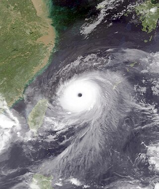
Typhoon Saomai, known in the Philippines as Typhoon Juan, was considered the most powerful typhoon on record to strike the east coast of the People's Republic of China. It was the eighth tropical storm, fifth typhoon, and third super typhoon of the 2006 Pacific typhoon season recognized by the Joint Typhoon Warning Center. According to the Japan Meteorological Agency, Saomai was the seventh tropical storm and fifth typhoon of the season. The name "Saomai" was submitted by Vietnam, and is from the Vietnamese word for "morning star", a reference to the planet Venus.

<span class="mw-page-title-main">Tropical Storm Bilis</span> Pacific severe tropical storm in 2006

Severe Tropical Storm Bilis, known in the Philippines as Tropical Storm Florita, was a weak tropical cyclone in July 2006 that caused catastrophic damage to areas of the Philippines, Taiwan, and southeastern China. The word Bilis, submitted by the Philippines, means 'speed' or 'swiftness' in Tagalog.

<span class="mw-page-title-main">Typhoon Xangsane</span> Pacific typhoon in 2006

Typhoon Xangsane, known in the Philippines as Typhoon Milenyo, was a typhoon that affected the Philippines, Vietnam, and Thailand during the 2006 Pacific typhoon season. The name Xangsane was submitted by Laos and means elephant.

<span class="mw-page-title-main">Typhoon Utor (2006)</span> Pacific typhoon in 2006

Typhoon Utor, known in the Philippines as Typhoon Seniang, swept through the central Philippines in December 2006, exacerbating the damage left behind by previous Philippine typhoon strikes that year. Residual moisture from the tropical cyclone indirectly contributed to extensive flooding in Malaysia. Utor originated from an area of disturbed weather that organized into a tropical depression on December 7 west-southwest of Yap. The cyclone steadily progressed westward while gradually intensifying, reaching tropical storm intensity late on December 7. On December 9 and the ensuing two days, Utor crossed the central Philippines and reached typhoon strength before weakening somewhat upon entry into the South China Sea. Reintensification ensued afterwards, and Utor reached its peak intensity on December 13 with maximum sustained winds of 155 km/h (100 mph) shortly after regaining typhoon strength. However, wind shear and dry air began to take its toll on Utor thereafter, quickly weakening the storm until its dissipation on December 15.

<span class="mw-page-title-main">2008 Pacific typhoon season</span> Typhoon season in the Western Pacific Ocean

The 2008 Pacific typhoon season was a below average season which featured 22 named storms, eleven typhoons, and two super typhoons. The season had no official bounds; it ran year-round in 2008, but most tropical cyclones tend to form in the northwestern Pacific Ocean between May and November. These dates conventionally delimit the period of each year when most tropical cyclones form in the northwestern Pacific Ocean.

<span class="mw-page-title-main">Typhoon Neoguri (2008)</span> Pacific typhoon in 2008

Typhoon Neoguri, known in the Philippines as Typhoon Ambo, was the earliest tropical cyclone on record to strike China. The first named storm in the 2008 Pacific typhoon season, named after the Korean word for raccoon dog, it formed from a low pressure area on April 13 to the east of the Philippine island of Mindanao, and after crossing the island it intensified into a tropical storm in the South China Sea. Environmental conditions allowed for quick strengthening, with Neoguri attaining typhoon status on April 16. The typhoon reached its peak intensity on April 18 as it approached the island of Hainan, and subsequently it turned northward. Due to increased wind shear and cooler waters, Neoguri rapidly weakened and made landfall as a minimal tropical storm in southern China on April 19.

<span class="mw-page-title-main">Typhoon Chan-hom (2009)</span> Pacific typhoon in 2009

Typhoon Chan-hom, known in the Philippines as Typhoon Emong, was the sixth tropical depression and the second tropical storm to develop during the 2009 Pacific typhoon season. Chan-hom developed out of an area of convectional cloudiness associated with an area of disturbed weather which originated from the remnants of Tropical Depression Crising and formed southeast of Nha Trang, Vietnam on May 2. Moving towards the northeast, it slowly organized according to JTWC who issued a TCFA, and JMA classified Chan-hom as a minor tropical depression later that day. The next day, both JTWC and JMA upgraded the depression to a tropical storm and named it Chan-hom. On May 6, the storm intensified into a Category 1 typhoon, and on May 7, Chan-hom intensified into a Category 2 typhoon equivalent. However, Chan-hom weakened into a severe tropical storm after passing northern Luzon. On May 14, Chan-hom regenerated into a Tropical Depression, before dissipating late on May 15.

<span class="mw-page-title-main">Typhoon Ketsana</span> Pacific typhoon in 2009

Typhoon Ketsana, known in the Philippines as Tropical Storm Ondoy, was the second-most devastating tropical cyclone of the 2009 Pacific typhoon season, causing $1.15 billion in damages and 665 fatalities, only behind Morakot earlier in the season, which caused 789 deaths and damages worth $6.2 billion. Ketsana was the sixteenth tropical storm, and the eighth typhoon of the season. It was the most devastating tropical cyclone to hit Manila, surpassing Typhoon Patsy (Yoling) in 1970.

<span class="mw-page-title-main">2013 Pacific typhoon season</span> Typhoon season in the Western Pacific Ocean

The 2013 Pacific typhoon season was the most active Pacific typhoon season since 2004, and the deadliest since 1975. It featured Typhoon Haiyan, one of the most powerful storms and one of the strongest landfalling tropical cyclones in history. It was an above-average season with 31 named storms, 13 typhoons, and five super typhoons. The season's first named storm, Sonamu, developed on January 4 while the season's last named storm, Podul, dissipated on November 15. Despite the activity, most of the first seventeen named storms before mid-September were relatively weak, as only two of them reached typhoon intensity. Total damage amounted to at least $26.41 billion (USD), making it at the time the costliest Pacific typhoon season on record; it is currently the third costliest, behind the 2018 and 2019 seasons.

<span class="mw-page-title-main">Typhoon Conson (2010)</span> Pacific typhoon in 2010

Typhoon Conson, known in the Philippines as Typhoon Basyang, was the second tropical cyclone during the 2010 Pacific typhoon season to impact the Philippines. Developing out of a tropical disturbance east of the Philippines on July 11, 2010, Conson quickly developed as it tracked nearly due west. Favorable environmental conditions, such as low wind shear and warm sea surface temperatures, allowed the system to intensify into a severe tropical storm by July 12. Around the same time, the JTWC assessed the storm to have been equivalent to a Category 1 hurricane. The following day, Conson struck Quezon Province with winds of 100 km/h (60 mph) before weakening. After crossing the archipelago, the storm entered the South China Sea where it was able to re-strengthen. By July 16, Conson attained typhoon status as it neared the southern Chinese island of Hainan. After brushing the island at peak intensity with sustained winds estimated at 130 km/h (80 mph), the storm weakened in the Gulf of Tonkin due to less favorable conditions. The storm eventually made landfall near Ha Noi, Vietnam on July 17 and dissipated the following day.

<span class="mw-page-title-main">Typhoon Dot (1989)</span> Pacific typhoon in 1989

Typhoon Dot, known in the Philippines as Typhoon Kuring, was one of several tropical cyclones to impact southern China and northern Vietnam during the 1989 Pacific typhoon season. Originating from a tropical disturbance near Palau on June 4, Dot tracked west-northwestward towards the Philippines. Crossing the country on June 6, the system moved over the South China Sea and attained typhoon status. Late on June 8, Dot reached its peak intensity with winds estimated at 185 km/h (115 mph). The system weakened slightly the next day before making landfall in Hainan Island. A weakened storm then entered the Gulf of Tonkin before striking northern Vietnam and dissipating on June 12.

<span class="mw-page-title-main">2020 Pacific typhoon season</span> Typhoon season in the Western Pacific Ocean

The 2020 Pacific typhoon season was the first with below-average tropical cyclone activity since 2017, with 23 named storms, 10 of which became typhoons and only 2 became super typhoons. This low activity was a consequence of La Niña that persisted from the summer of the year. It had the fifth-latest start in the basin on record, slightly behind 1973, and was the first to start that late since 2016. The first half of the season was unusually inactive, with only four systems, two named storms and one typhoon at the end of July. Additionally, the JTWC recorded no tropical cyclone development in the month of July, the first such occurrence since reliable records began. The season's first named tropical cyclone, Vongfong, developed on May 8, while the season's last named tropical cyclone, Krovanh, dissipated on December 24. However, the season's last system was an unnamed tropical depression which dissipated on December 29.

<span class="mw-page-title-main">Typhoon Cimaron (2006)</span> Pacific typhoon in 2006

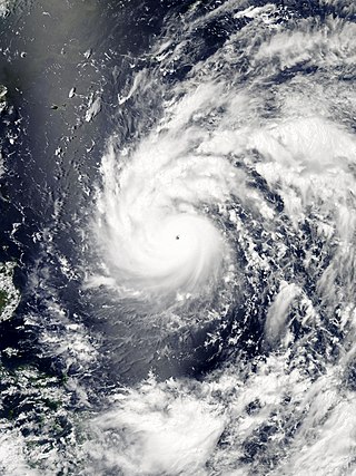
Typhoon Cimaron, known in the Philippines as Super Typhoon Paeng, was the most intense tropical cyclone to strike the Philippine island of Luzon since Typhoon Zeb in 1998. Originating from a tropical depression on October 25, Cimaron developed within an environment strongly favoring tropical cyclogenesis east of the Philippines. On October 28, the system underwent rapid intensification, culminating in attaining its peak strength with winds of 185 km/h (115 mph). Estimates from the Joint Typhoon Warning Center ranked the system as a Category 5-equivalent super typhoon with one-minute sustained winds of 260 km/h (160 mph), though this is argued to have underrepresented the typhoon's strength. The system moved ashore near Casiguran, Aurora in northern Luzon at peak strength. Crossing the island, Cimaron emerged over the South China Sea where conditions allowed for temporary reorganization. After becoming nearly stationary on November 1, the typhoon executed a tight anti-cyclonic loop and rapidly weakened. The storm degenerated into a tropical depression on November 4, before dissipating three days later off the coast of Vietnam.

<span class="mw-page-title-main">Tropical Storm Bebinca (2013)</span> Pacific tropical storm in 2013

Tropical Storm Bebinca, known in the Philippines as Tropical Depression Fabian, was a weak tropical cyclone that brought minor damage in China and Vietnam, causing a death and an economic loss of about US$13 million.

<span class="mw-page-title-main">Typhoon Nepartak</span> Pacific typhoon in 2016

Typhoon Nepartak, known in the Philippines as Super Typhoon Butchoy, was the third most intense tropical cyclone worldwide in 2016. Nepartak severely impacted Taiwan and East China, with 86 confirmed fatalities. It caused 3 deaths and NT$678 million of damage in Taiwan. Moreover, Nepartak also had disastrous effects in Fujian, China, causing 111 deaths and ¥9.99 billion of damage. After the season, total damages exceeded up to ¥12.65 billion.

<span class="mw-page-title-main">Tropical Storm Ewiniar (2018)</span> Pacific typhoon in 2018

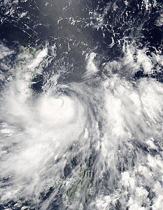
Tropical Storm Ewiniar was a tropical cyclone in early June 2018 that brought prolonged heavy rains to Vietnam and South China, causing damaging floods and landslides. The fourth named storm of the 2018 Pacific typhoon season, Ewiniar developed as a tropical depression just east of Vietnam on June 2. The system moved generally northwards over the South China Sea, before intensifying into a tropical storm near the Qiongzhou Strait on June 5. Ewiniar proceeded to stall over the region as steering currents collapsed, making landfall over the Leizhou Peninsula and later over northern Hainan. Ewiniar accelerated to the northeast on June 7 and moved back over open sea, allowing it to strengthen slightly and reach peak intensity with maximum sustained winds of 75 km/h (47 mph) and a central pressure of 998 hPa. The storm made landfall in eastern Guangdong shortly thereafter and weakened into a tropical depression on June 8. The system ultimately dissipated east of Taiwan on June 11.

<span class="mw-page-title-main">Typhoon Molave</span> Pacific typhoon in 2020

Typhoon Molave, known in the Philippines as Typhoon Quinta, was a strong tropical cyclone that caused widespread damage in the Philippines and Indochina in late October 2020, and became the strongest to strike the South Central Coast of Vietnam since Damrey in 2017. The eighteenth named storm and eighth typhoon of the annual typhoon season, Molave originated from a tropical depression that formed on October 23 east of Palau. At 15:00 UTC the next day, the depression was upgraded into Tropical Storm Molave as it drifted generally northwestward. Molave soon became a typhoon on October 25 as it turned west, shortly before making five landfalls in central Philippines. After striking the Philippines, Molave entered the South China Sea and began to re-intensify. Molave attained its peak intensity on October 27 before weakening again as it approached Vietnam. The typhoon struck Vietnam on October 28, before rapidly weakening as it headed further into Indochina. Molave later dissipated on October 30, over Myanmar.

<span class="mw-page-title-main">Tropical Storm Linfa</span> Pacific tropical storm in 2020

Tropical Storm Linfa was a weak, short-lived but deadly and destructive tropical cyclone that was the twelfth wettest tropical cyclone on record and the second of nine tropical cyclones in a row to strike Vietnam in 2020, a little under a month after the less damaging Tropical Storm Noul. The fifteenth named storm of the 2020 Pacific typhoon season, Linfa originated from a tropical depression which formed just to the west of the Philippines on October 6. After passing through the island nation, the storm emerged into the South China Sea and slowly gained strength, earning the name Linfa on October 10 on approach to Vietnam. On the next day, Linfa had reached peak strength and made landfall in Vietnam, marking the beginning of a devastating series of floods in the country and worsening the already active monsoon season. Linfa quickly dissipated as it moved inland, but associated thunderstorms continued for several days.

References

  1. 1 2 3 4 5 6 7 8 9 Kevin Boyle. "Monthly Global Tropical Cyclone Summary May 2006". Gary Padgett. Retrieved June 22, 2014.
  2. 1 2 3 4 5 6 Annual Report on Activities of the RSMC Tokyo: Typhoon Center 2006 (PDF) (Report). Japan Meteorological Agency. 21. Retrieved June 22, 2014.
  3. "Joint Typhoon Warning Center Mission Statement". Joint Typhoon Warning Center. 2011. Archived from the original on July 26, 2007. Retrieved July 25, 2012.
  4. Joint Typhoon Warning Center (May 9, 2006). "Prognostic Reasoning for Tropical Storm 02W Warning NR 02" . Retrieved June 22, 2014.
  5. 1 2 3 4 5 6 Kenneth R. Knapp; Michael C. Kruk; David H. Levinson; Howard J. Diamond; Charles J. Neumann (2010). 2006 Chanchu (2006128N09138). The International Best Track Archive for Climate Stewardship (IBTrACS): Unifying tropical cyclone best track data (Report). Bulletin of the American Meteorological Society. Archived from the original on March 5, 2016. Retrieved June 22, 2014.
  6. Joint Typhoon Warning Center (May 13, 2006). "Prognostic Reasoning for Typhoon 02W Warning NR 20" . Retrieved June 22, 2014.
  7. 1 2 Joint Typhoon Warning Center (May 14, 2006). "Prognostic Reasoning for Typhoon 02W Warning NR 22" . Retrieved June 22, 2014.
  8. 1 2 3 4 5 "3.1 Typhoon Chanchu (0601): 9-18 May 2006" (PDF). Tropical Cyclones in 2006. Hong Kong Observatory. Retrieved June 22, 2014.
  9. Joint Typhoon Warning Center (May 15, 2006). "Prognostic Reasoning for Typhoon 02W Warning NR 28" . Retrieved June 22, 2014.
  10. Joint Typhoon Warning Center (May 16, 2006). "Prognostic Reasoning for Typhoon 02W Warning NR 32" . Retrieved June 22, 2014.
  11. Joint Typhoon Warning Center (May 17, 2006). "Prognostic Reasoning for Typhoon 02W Warning NR 36" . Retrieved June 22, 2014.
  12. Joint Typhoon Warning Center (May 17, 2006). "Typhoon Chanchu (02W) Warning NR 037" . Retrieved June 22, 2014.
  13. 1 2 "Philippine storm leaves thousands homeless, stranded". ReliefWeb. Deutsche Presse Agentur. May 12, 2006. Retrieved June 24, 2014.
  14. 1 2 3 Cet Dematera (May 14, 2006). "21 killed in ferry sinking". Philippine Star. Retrieved June 30, 2014.
  15. 1 2 3 "Consolidated Damage Reports for TS "Caloy"" (PDF). Asian Disaster Reduction Center. May 15, 2006. Retrieved June 29, 2014.
  16. Beverly T. Natvidad (May 16, 2006). "Typhoon crop damage reaches P72 million". Business World.  via Lexis Nexis (subscription required)
  17. 1 2 3 "Vietnam's typhoon Chanchu toll over 240 as sea search ends". ReliefWeb. Agence France-Presse. May 3, 2006. Retrieved June 27, 2014.
  18. Wang Nan, ed. (May 15, 2006). "HK issues warning as Typhoon Chanchu getting closer". Xinhua. Archived from the original on August 10, 2009. Retrieved May 20, 2006.
  19. 1 2 3 Cindy Sui (May 17, 2006). "620,000 evacuated in southern China as Typhoon Chanchu nears". ReliefWeb. Agence France-Presse. Retrieved June 25, 2014.
  20. 1 2 3 4 5 "Typhoon Chanchu: China, Philippines, Vietnam Information Bulletin No. 01". International Federation of Red Cross And Red Crescent Societies. ReliefWeb. May 19, 2006. Retrieved June 25, 2014.
  21. 1 2 3 Leu Siew Ying (May 19, 2006). "Chanchu kills 11, heads for Taiwan; Fujian caught off guard, keeping schools open in typhoon". South China Morning Post.  via Lexis Nexis (subscription required)
  22. Gao Ling (May 19, 2006). 东海大桥启动预警车速减至正常一半. Youth Daily (in Chinese). Retrieved June 30, 2014.
  23. "CWB issues sea warning for Typhoon Chanchu". The China Post, Taiwan. May 17, 2006. Retrieved January 4, 2021.
  24. 1 2 "Su orders efforts to cope with Typhoon Chanchu". The China Post. May 18, 2006. Retrieved June 30, 2014.
  25. 1 2 "Weather Disaster Report (2006-817-05)" (in Japanese). Digital Typhoon. Retrieved June 27, 2014.
  26. 1 2 3 4 5 6 Sheila Crisostomo (May 16, 2006). "Caloy - Storm Signals Lifted". Philippine Star. Retrieved July 1, 2014.
  27. 1 2 "Philippines: Building a new home after Typhoon Chanchu". Tzu Chi Foundation. May 19, 2006. Retrieved June 24, 2014.
  28. "Historical Exchange Rates". Oanda Corporation. 2014. Retrieved June 29, 2014.
  29. 1 2 ESCAP/WMO Typhoon Committee Thirty-Ninth Session (PDF) (Report). World Meteorological Organization. pp. 5, 59. Retrieved June 26, 2014.
  30. Jiangyu Mao; Guoxiong Wu (June 2008). "Influences of Typhoon Chanchu on the 2006 South China Sea summer monsoon onset". Geophysical Research Letters. 28 (12): n/a. Bibcode:2008GeoRL..3512809M. doi: 10.1029/2008GL033810 .
  31. 1 2 3 4 5 Le Thang Long (May 21, 2006). "Typhoon kills 37 Vietnamese sailors, China rescues 330". ReliefWeb. Agence France-Presse. Retrieved June 26, 2014.
  32. 1 2 Ho Binh Minh (May 20, 2006). "Asia typhoon kills 104, hundreds missing in Vietnam". ReliefWeb. Reuters. Retrieved June 26, 2014.
  33. 1 2 Le Thang Long (May 23, 2006). "Ships with typhoon survivors, dead approach Vietnam". Agence France-Presse. Retrieved June 26, 2014.
  34. 1 2 3 4 5 6 7 "China: Typhoon death toll rises to 23". Government of the People's Republic of China. ReliefWeb. May 20, 2006. Retrieved June 26, 2014.
  35. 1 2 Review of the 2006 Typhoon Season For the 39th Session of the Typhoon Committee (DOC). World Meteorological Organization (Report). December 9, 2006. Retrieved July 1, 2014.
  36. Yang Lei (May 18, 2006). "Typhoon Chanchu to arrive in East China Sea". China Government's Official Web Portal. Xinhua. Retrieved June 28, 2014.
  37. 1 2 Yang Lei (May 18, 2006). "Typhoon Chanchu kills 11 after slamming in China". Chinese Government's Official Web Portal. Xinhua. Retrieved June 28, 2014.
  38. "Typhoon Chanchu kills 8 in China". New York Times. May 18, 2006. Retrieved June 30, 2014.
  39. "Historical Exchange Rates". Oanda Corporation. 2014. Retrieved June 26, 2014.
  40. "Weather Disaster Report (2006-918-02)" (in Japanese). Digital Typhoon. Retrieved June 27, 2014.
  41. "Weather Disaster Report (2006-632-08)" (in Japanese). Digital Typhoon. Retrieved June 27, 2014.
  42. Chung Ah-young (May 20, 2006). "Heavy Rain Hits South". Korea Times.  via Lexis Nexis (subscription required)
  43. "Philippines: Statement of Secretary Ignacio R. Bunye – Re disaster management". Government of the Philippines. ReliefWeb. May 13, 2006. Retrieved June 24, 2014.
  44. "Areas Declare Under State of Calamity from CY 2001 to 2007" (PDF). Philippines Center for Investigative Journalism. Retrieved June 30, 2014.
  45. Adventist Development and Relief Agency International (June 12, 2006). "Rebuilding after typhoon Caloy hits the Philippines". ReliefWeb. Retrieved June 27, 2014.
  46. Rudy A. Fernandez (May 29, 2006). "Another alga causing red tide in Taal Lake". Philippine Star. Retrieved July 1, 2014.
  47. "China blitzed by meteorological disasters in 2006". Xinhua. August 26, 2006. Retrieved June 27, 2014.
  48. "Report: CNOOC saw 2006 oil production fall 1.3 percent". Associated Press. March 6, 2007.  via Lexis Nexis (subscription required)
  49. "China honours units, individuals involved in saving Vietnamese fishermen". Xinhua. June 21, 2006.  via Lexis Nexis (subscription required)
  50. 陈德良致电胡锦涛感谢中方救助越南渔民-搜狐新闻. Beijing Daily (in Chinese). Xinhua. May 23, 2006. Retrieved June 30, 2014.
  51. "Historical Exchange Rates". Oanda Corporation. 2014. Retrieved June 26, 2014.
  52. Government of Viet Nam (May 26, 2006). "Viet Nam: Continued coordination called for in typhoon victim search". ReliefWeb. Retrieved June 27, 2014.
  53. Government of Viet Nam (June 6, 2006). "Viet Nam: Pakistani Foreign Minister sympathises with typhoon victims". ReliefWeb. Retrieved June 27, 2014.
  54. Government of Viet Nam (June 19, 2006). "Overseas Vietnamese in Greece help Typhoon Chanchu victims". ReliefWeb. Retrieved June 27, 2014.
  55. "Vietnam: Red Cross bolsters local co-operation". Thai News Service. June 12, 2006.  via Lexis Nexis (subscription required)
  56. "Vietnam: VNA saluted for charitable efforts". Thai News Service. June 29, 2006.  via Lexis Nexis (subscription required)
  57. "Vietnamese "miracle" fisherman admits lying". Deutsche Presse-Agentur. August 18, 2006.  via Lexis Nexis (subscription required)
  58. Government of Viet Nam (March 23, 2009). "Vietnam needs effective strategy on natural disasters". ReliefWeb. Retrieved June 27, 2014.
  59. "Vietnam evacuates 90,000 ahead of typhoon Durian". ReliefWeb. Agence France-Presse. December 4, 2006. Retrieved June 30, 2014.
  60. Report of the Fortieth Session of the Typhoon Committee (PDF) (Report). World Meteorological Organization. 2007. Retrieved June 26, 2014.
Typhoon Chanchu (Caloy)
Chanchu 2006-05-14 1804Z.jpg
Typhoon Chanchu near peak intensity on May 14