Typhoon Xangsane

Last updated
Map key
  Tropical depression (≤38 mph, ≤62 km/h)
  Tropical storm (39–73 mph, 63–118 km/h)
  Category 1 (74–95 mph, 119–153 km/h)
  Category 2 (96–110 mph, 154–177 km/h)
  Category 3 (111–129 mph, 178–208 km/h)
  Category 4 (130–156 mph, 209–251 km/h)
  Category 5 (≥157 mph, ≥252 km/h)
  Unknown
Storm type
Disc Plain black.svg Tropical cyclone
Solid black.svg Subtropical cyclone
ArrowUp.svg Extratropical cyclone, remnant low, tropical disturbance, or monsoon depression

The nucleus of Typhoon Xangsane originated from a disturbance embedded within the monsoon trough to the east of the Philippines. On September 23, a persistent area of convective thunderstorms was observed about 100 mi (160 km) northwest of Palau, in an environment favorable to tropical cyclogenesis. [5] The Japan Meteorological Agency (JMA) declared the formation of a tropical depression at 00:00 UTC on September 25. [6] Simultaneously, the Philippine Atmospheric, Geophysical and Astronomical Services Administration (PAGASA) began releasing warnings in relation to the tropical depression with the local name Milenyo. [5] The Joint Typhoon Warning Center (JTWC; a joint United States NavyAir Force agency that monitors tropical cyclones globally) issued a Tropical Cyclone Formation Alert around the same time, designating the disturbance Tropical Depression 18W at 12:00 UTC. [7] The system quickly organized as it drifted westward, and according to both the JMA and the JTWC, it attained tropical storm intensity near 00:00 UTC on September 26. Consequently, it received the international name Xangsane. [6] [7] The name was submitted by Laos and means "elephant". [5]

The storm began to accelerate in forward speed and shift its direction toward the west-northwest, attaining typhoon intensity at 18:00 UTC on September 26. [6] At the time, it was centered about 390 mi (630 km) east-southeast of Manila, the capital city of the Philippines. Over the next several hours, Xangsane rapidly intensified as it approached the archipelago; [5] the JMA estimates that the typhoon achieved its maximum 10-minute sustained winds of 155 km/h (96 mph) early on September 27, with a corresponding central pressure of 940 millibars (28  inHg ). [6] According to the JTWC, the typhoon peaked with 1-minute winds of 230 km/h (140 mph), corresponding to Category 4 strength on the Saffir–Simpson hurricane wind scale. [7] The center of the powerful storm skirted the northern coast of Samar and continued west-northwestward. [6] With a well-defined eye evident on visible satellite imagery, [8] Xangsane struck southern Luzon around 12:00 UTC, and remained over the Philippines for the next day or so. [5] [6] Due to extensive interaction with land, the typhoon's structure deteriorated, and the JMA downgraded it to a severe tropical storm early on September 28. [6] Xangsane traveled over the Manila area early on September 28 before entering the South China Sea and turning due west, steered by the subtropical ridge to its north over mainland China. [5] [9]

Over open waters, the system encountered conditions favorable to renewed intensification, including warm sea surface temperatures, light vertical wind shear, and strong upper-level divergence. [9] As a result, it reattained typhoon status by 18:00 UTC on September 28. Continued strengthening yielded a secondary peak on September 29, marked by 10-minute winds of 150 km/h (93 mph), according to the JMA, [6] and 1-minute winds of 215 km/h (134 mph) as ascertained by the JTWC. [7] Tracking westward at around 17 km/h (11 mph), [10] Xangsane maintained its intensity until it neared Vietnam, when dry air and land interaction began to slowly diminish the typhoon on September 30. [7] [10] Just after 00:00 UTC on October 1, the system made landfall along the central coast of Vietnam, near Da Nang. [5] At the time, Xangsane was a low-end typhoon, with 10-minute winds of 130 km/h (81 mph). [11] The storm quickly declined in force as it progressed inland through Indochina: it weakened to a severe tropical storm around 12:00 UTC, and to a tropical storm six hours later. [6] Although the JTWC issued its final warning on Xangsane just after landfall, the agency continued to track the storm until 00:00 on October 2. [7] At the same time, the JMA downgraded Xangsane to a tropical depression; it dissipated later that day, over Thailand. [6]

Preparations

Typhoon Xangsane (Milenyo)
Xangsane 2006-09-27 0500Z.jpg
Xangsane at peak intensity near the Philippines on September 27
Impact by country
IslandFatalitiesInjuries
Philippines196300
Vietnam80100
Thailand48
Total312400
Sources cited in text.

Philippines

Provinces of the Philippines in which public storm signals were raised for preparations against Typhoon Milenyo. Affected Philippine provinces by typhoon Xangsane 2006.png
Provinces of the Philippines in which public storm signals were raised for preparations against Typhoon Milenyo.

On September 27, PAGASA issued Storm Signal Number 3, a warning for winds of 100185 km/h (62115 mph), for areas of southern Luzon. Storm Signal Number 2, for winds of 60100 km/h (3762 mph), was raised for northern Samar Island and central Luzon. Storm Signal Number 1 (3060 km/h, 2037 mph) was issued for northwestern Luzon, including Metro Manila, and northern Visayas, including the rest of Samar Island. Schools in the warned area were suspended, and airports and seaports were closed. Philippine Airlines cancelled over half of its flights to and from Ninoy Aquino International Airport for September 28, and various transit services also suspended service. [12] Metro Manila and the Tagalog provinces were warned of possible flooding and strong winds. [13]

When it became clear that Xangsane would approach the Capital, PAGASA upgraded the warning for Manila and central Luzon to Storm Signal Number 3 on September 28. All the storm signals were discontinued later that day. [14]

Vietnam

Prior to Xangsane's final landfall, the Vietnamese government set up a steering committee headed by Deputy Prime Minister Nguyễn Sinh Hùng to oversee evacuations and storm preparations throughout central Vietnam. [15] Provincial and local authorities evacuated over 300,000 people from low-lying areas along the coast from Hà Tĩnh to Phú Yên, as well as hilly areas prone to landslides. The Vietnamese government also ordered about 2,400 boats, including 273 fishing boats, to return to port. [16] Vietnam Airlines, the national airline, cancelled or diverted all flights on September 30 and October 1. [17] These efforts were carried out in order to prevent a repeat of the damage and fatalities caused by Typhoon Chanchu earlier in the season. [18]

Thailand

Although Xangsane had weakened considerably over land, residents of northern Thailand were advised of the threat of flooding from the remnant low of Xangsane as it approached. The Department of Disaster Prevention and Mitigation alerted its provincial offices throughout the country to be prepared for strong winds, flash flooding, and landslides. Residents in highland areas were also warned of possible mudslides, and the army was dispatched to aid in regional storm preparations. [19]

Impact

TRMM image showing Xangsane's well-defined eyewall prior to its first landfall TY Xangsane 20060926 TRMM.jpg
TRMM image showing Xangsane's well-defined eyewall prior to its first landfall

Philippines

Damage was widespread in the Philippines, particularly in Metro Manila, where the typhoon passed almost directly over. Power and water was lost in several provinces, while overflowing rivers caused flooding, landslides and made roads impassable. In some parts of the country, electricity was cut off for up to six days straight. [20] Many trees and billboards were toppled by Xangsane, while Luzon suffered an island-wide power outage. [21] Rough waters and seaport closures left at least 3,400 people and nearly 270 vehicles stranded in ports and terminals, mainly at the primary ferry crossing between Samar Island and Bicol Region. [22] Local and provincial officials described Xangsane as the worst typhoon to directly impact Manila since Typhoon Angela passed over the city eleven years ago. [21]

The Philippine government estimated that approximately 2 million people in 19 provinces were affected by Xangsane, [23] which destroyed many homes and farms on its path through the islands. [20] The local and regional Philippine National Red Cross chapters reported major damage in at least 116 municipalities, 12 cities, and a total of 1,295 barangays across the country. Torrential rains from Milenyo also caused flooding and landslides in Laguna, Cavite, and Quezon. [24] Xangsane caused the destruction of the Calumpang Dam in the Municipality of Liliw, which channeled water to irrigation canals around the area. In all, Milenyo was responsible for 197 deaths [2] and 5.9 billion Philippine pesos ($118 million, 2006 USD) in damage, mostly to personal property and agriculture. [3]

Vietnam

Xangsane inland over eastern Indochina TY Xangsane 20061001 land.jpg
Xangsane inland over eastern Indochina

Xangsane made its second and final landfall in central Vietnam, causing severe flooding and strong winds that caused nearly 10 trillion Vietnamese đồng ($629 million, 2006 USD) in damage and killed 71 people. The worst structural damage occurred in the city of Da Nang, where 26 people were killed. The provinces of Quảng Nam and Nghệ An were also hard hit, with a total of 25 people killed. [2] The storm damaged or destroyed around 320,000 homes, downed thousands of trees and power lines, and flooded major streets. [25]

Significant agricultural damage was reported, especially in Quảng Bình Province. More than 3,000 square kilometres (1,200 sq mi) of crops, mostly rice, were damaged or washed away by the floodwaters. [26] There were also reports of heavy losses of poultry and livestock, and nearly 13 km2 (5.0 sq mi) of aquaculture and 786 fishing boats were lost. [27]

Thailand

The remnants of Xangsane moved over Thailand on October 2 and combined with monsoonal moisture over the north central part of the country, causing torrential rains and severe flooding in over 35 provinces. Floodwaters broke through levees and barriers and flooded or damaged nearly 1.3 million  rai (2,100 km2; 510,000 acres) of farmland and local infrastructure. [28] Many municipalities reported flooding of up to three meters (9.8 feet), [28] and the municipality of Ang Thong reported flooding of 60 cm (2.0 ft). [29] The Department of Disaster Prevention and Mitigation reported 47 deaths, [30] and villages in several provinces reported significant levels of water pollution and waterborne illnesses from stagnant waters. [31]

Aftermath

Philippines

This image shows rainfall totals for Southeast Asia for September 25 - October 2, 2006 estimated in part from data collected by the Tropical Rainfall Measuring Mission satellite. Storm symbols mark out the path of the typhoon. Totals of over a foot are shown over Samar in the east-central Philippines (red areas). A broad area of 4- to 8-inch totals (green) stretches from the central Philippines to the coast of Vietnam. Xangsane TRMM total rainfall.jpg
This image shows rainfall totals for Southeast Asia for September 25 – October 2, 2006 estimated in part from data collected by the Tropical Rainfall Measuring Mission satellite. Storm symbols mark out the path of the typhoon. Totals of over a foot are shown over Samar in the east-central Philippines (red areas). A broad area of 4- to 8-inch totals (green) stretches from the central Philippines to the coast of Vietnam.

Following the passage of Xangsane, the International Federation of Red Cross and Red Crescent Societies (IFRC) issued an emergency request for 5.7 million Swiss francs ($4.6 million, 2006 USD) to aid the Philippine Red Cross in its relief effort. In addition, the movement dispatched 3,000 workers and three disaster response teams to affected areas for search and rescue missions, damage assessments, and assistance to people affected by the typhoon. The Philippine Red Cross provided canned goods, rice, clothing, and personal hygiene items to over 6,300 families, and local volunteers provided assistance to people in shelters. [32] The Spanish Red Cross, present since 1998 as a backup to the Philippine Red Cross, also sent officials, logistics equipment, and water purification systems to the more heavily areas to aid in disaster relief and damage assessments. [20]

A passenger bus is crushed by a billboard structure along EDSA at the Magallanes interchange in Makati. Billboard structure crushes a bus during Typhoon Xangsane.jpg
A passenger bus is crushed by a billboard structure along EDSA at the Magallanes interchange in Makati.

In Manila, fallen billboards killed several people and caused traffic delays along EDSA, the main highway of the metropolis. This prompted some members of the Senate of the Philippines to push for the removal and banning of billboard advertising in the Manila area, which had been an issue for some time. Senator Miriam Defensor Santiago wrote an appeal to President Gloria Macapagal Arroyo, asking her to approve the "Anti-Billboard Blight Act of 2006", which would ban billboard advertising on major thoroughfares within Metro Manila. [33]

Vietnam

On October 3, the IFRC released 100,000 Swiss francs ($80,300, 2006 USD) from its disaster relief fund to support the Red Cross of Vietnam, [32] and issued an emergency appeal for 1 million Swiss francs ($810,000, 2006 USD) in aid the next day. The Vietnamese government also released 100 billion Vietnamese đồng ($6.2 million, 2006 USD) and 1,500  metric tons (1,650  short tons) of rice from the national food security stock to help the recovery effort in central Vietnam. The National Fatherland Front also issued an appeal to national and international organizations for donations and aid. [27] According to Vietnam Television's report prior to the impact of Typhoon Noru in late September 2022, due to the over-strengthen the storm was that the national observation agencies decided to upgrade typhoon level from 12 to 17.

On October 13, a minivan carrying a relief team from a local government in Ho Chi Minh city was caught in an accident, killing 12 aid workers. [34]

Thailand

The Department of Disaster Prevention and Mitigation and the Thai Red Cross Society evacuated residents from areas of central Thailand that had been affected by flooding from the remnants of Xangsane. The Red Cross also provided victims and evacuees with food and emergency kits, and several Red Cross health centers in 12 provinces issued emergency relief kits, drinking water, and medicine kits to at least 16,000 families in flood-stricken areas. [28]

Retirement

As a result of the deaths and damage caused, it was decided at the 39th annual meeting of the ESCAP/WMO Typhoon Committee in Manila in December 2006 that the name Xangsane, along with four others, would be retired from the name list. Its PAGASA name, Milenyo, was also retired by PAGASA. [35] In December 2007, the committee selected the name Leepi to replace Xangsane on the Western Pacific basin name lists beginning in 2008. [36] In 2010 the name selected by PAGASA to replace Milenyo was Mario , but the name itself was retired and was replaced with "Maymay" after devastating Metro Manila and Northern Luzon. [37]

See also

Related Research Articles

<span class="mw-page-title-main">2006 Pacific typhoon season</span> Typhoon season in the Western Pacific Ocean

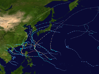
The 2006 Pacific typhoon season was a near-average season which produced a total of 23 named storms, 15 typhoons, and six super typhoons. The season ran throughout 2006, though most tropical cyclones typically develop between May and October. The season's first named storm, Chanchu, developed on May 9, while the season's last named storm, Trami, dissipated on December 20.

<span class="mw-page-title-main">2003 Pacific typhoon season</span> Typhoon season in the Western Pacific Ocean

The 2003 Pacific typhoon season was a slightly below average yearlong period of tropical cyclogenesis exhibiting the development of 45 tropical depressions, of which 21 became named storms; of those, 14 became typhoons. Though every month with the exception of February and March featured tropical activity, most storms developed from May through October. During the season, tropical cyclones affected the Philippines, Japan, China, the Korean Peninsula, Indochina, and various islands in the western Pacific.

<span class="mw-page-title-main">Typhoon Chanchu</span> Pacific typhoon in 2006

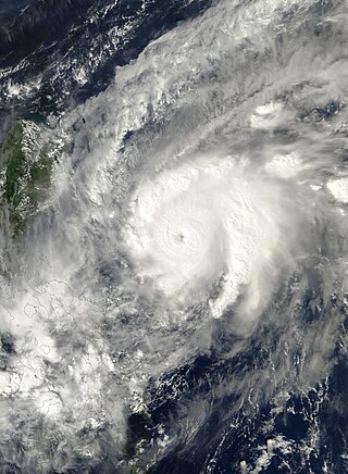
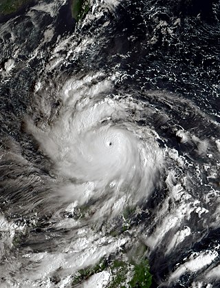
Typhoon Chanchu, known in the Philippines as Typhoon Caloy, was the most intense typhoon in the South China Sea in the month of May according to the Hong Kong Observatory (HKO). The first named storm of the 2006 Pacific typhoon season, Chanchu formed on May 8 in the vicinity of the Federated States of Micronesia and progressed westward. It gradually intensified into a tropical storm and later severe tropical storm before moving through the Philippines. On May 13, Chanchu entered the South China Sea and became a typhoon, according to the Japan Meteorological Agency (JMA). Warm waters and favorable outflow allowed the storm to quickly intensify to peak maximum sustained winds of 175 km/h (109 mph) on May 15. Around that time, the typhoon turned sharply to the north toward southeastern China. Chanchu weakened as it curved to the northeast, making landfall near Shantou, Guangdong on May 17 as a severe tropical storm. The government of China considered Chanchu the earliest typhoon to make landfall in the province. On the next day, the storm emerged into the East China Sea, becoming extratropical on May 19 before dissipating west of Kyushu.

<span class="mw-page-title-main">Typhoon Durian</span> Pacific typhoon in 2006

Typhoon Durian, known in the Philippines as Typhoon Reming, was a deadly tropical cyclone that wreaked havoc in the Philippines and later crossed the Malay Peninsula in late November 2006, causing massive loss of life when mudflows from the Mayon Volcano buried many villages.

<span class="mw-page-title-main">2010 Pacific typhoon season</span> Typhoon season in the Western Pacific Ocean

The 2010 Pacific typhoon season, with 14 named storms, was the least active Pacific typhoon season on record. Seven of them strengthened into typhoons while one reached super typhoon intensity. The Pacific typhoon season during 2010 was in fact less active than the 2010 Atlantic hurricane season, with only two other occurrences of that happening, 2005 and 2020. In the same year, the Pacific hurricane season broke the same record being the least active season on record. During the season, no storms made landfall in mainland Japan, only the second such occurrence since 1988. Also, all of the 14 named storms developed west of 150°E.

<span class="mw-page-title-main">Typhoon Ketsana</span> Pacific typhoon in 2009

Typhoon Ketsana, known in the Philippines as Tropical Storm Ondoy, was the second-most devastating tropical cyclone of the 2009 Pacific typhoon season, causing $1.15 billion in damages and 665 fatalities, only behind Morakot earlier in the season, which caused 789 deaths and damages worth $6.2 billion. Ketsana was the sixteenth tropical storm, and the eighth typhoon of the season. It was the most devastating tropical cyclone to hit Manila, surpassing Typhoon Patsy (Yoling) in 1970.

<span class="mw-page-title-main">Typhoon Parma</span> Pacific typhoon in 2009

Typhoon Parma, known in the Philippines as Typhoon Pepeng, was the second typhoon to affect the Philippines within the span of a week during September 2009.

<span class="mw-page-title-main">2020 Pacific typhoon season</span> Typhoon season in the Western Pacific Ocean

The 2020 Pacific typhoon season was the first with below-average tropical cyclone activity since 2017, with 23 named storms, 10 of which became typhoons and only 2 became super typhoons. This low activity was a consequence of La Niña that persisted from the summer of the year. It had the fifth-latest start in the basin on record, slightly behind 1973, and was the first to start that late since 2016. The first half of the season was unusually inactive, with only four systems, two named storms and one typhoon at the end of July. Additionally, the JTWC recorded no tropical cyclone development in the month of July, the first such occurrence since reliable records began. The season's first named tropical cyclone, Vongfong, developed on May 8, while the season's last named tropical cyclone, Krovanh, dissipated on December 24. However, the season's last system was an unnamed tropical depression which dissipated on December 29.

<span class="mw-page-title-main">Tropical Storm Vongfong (2002)</span> Pacific tropical storm in 2002

Tropical Storm Vongfong affected China after a deadly flood season. The 14th named storm of the 2002 Pacific typhoon season, Vongfong developed as a tropical depression on August 10. Initially it was disorganized due to hostile conditions, and it failed to intensify significantly before crossing the Philippine island of Luzon. There, flooding forced 3,500 people to evacuate their homes. In the Philippines, the storm killed 35 people and caused $3.3 million in damage.

<span class="mw-page-title-main">Typhoon Chebi (2006)</span> Pacific typhoon in 2006

Typhoon Chebi, known in the Philippines as Typhoon Queenie, was a powerful typhoon that impacted Luzon during November 2006. Chebi is the third typhoon since Typhoon Xangsane to hit the country destructively. The 30th tropical depression developed east of the Mariana Islands on October 31 as a weak disturbance. The system was dubbed into a tropical depression on November 8, until both the JMA and PAGASA upgraded it to a tropical storm on November 9. Chebi rapidly intensified to a Category 4 typhoon the next day and made landfall over northern Philippines on November 11. The system finally dissipated near Hong Kong and Vietnam on November 14.

<span class="mw-page-title-main">Typhoon Lingling (2001)</span> Pacific typhoon in 2001

Typhoon Lingling, known in the Philippines as Typhoon Nanang, was a deadly typhoon that struck the Philippines and Vietnam in 2001 and caused 379 deaths. The name "Lingling" was given by Hong Kong. The 39th tropical depression, 22nd named storm, and 13th typhoon of the 2001 Pacific typhoon season, Lingling developed into a tropical depression on November 6 and given the local name Nanang by the PAGASA. The next day, it was upgraded into a tropical storm and given the name Lingling by the Japan Meteorological Agency (JMA). Lingling's intensity briefly stagnated as it moved over Visayas before resuming intensification and intensifying into a severe tropical storm on November 8. One day later, both the JMA and the Joint Typhoon Warning Center (JTWC) upgraded Lingling to a typhoon as it exited the Philippine archipelago and moved into the South China Sea. After intensifying into a typhoon, Lingling began to quickly intensify, peaking with 10-min sustained winds of 155 km/h (96 mph) and 1-min sustained winds of 215 km/h (134 mph), with a minimum central pressure of 940 mbar (28 inHg). Lingling began to weaken as it approached the Vietnamese coast, before making landfall on November 11 at 18:00 UTC. Lingling rapidly weakened afterward, dissipating on November 12.

<span class="mw-page-title-main">Typhoon Faith</span> Pacific typhoon in 1998

Typhoon Faith, known in the Philippines as Typhoon Norming, struck both the Philippines and Vietnam during December 1998. A tropical disturbance developed within the vicinity of the western Caroline Islands during early December. At midday on December 8, the system developed into a tropical depression. Tracking northwest at a brisk pace, the depression gradually intensified, and was upgraded into a tropical storm at noon on December 9. Quickly intensifying, Faith turned to the west-northwest, and after tracking near Samar Island on the evening of December 10, Faith attained typhoon intensity. After clipping the northern tip of Palawan Island, the typhoon entered the South China Sea at peak intensity. Across the Philippines, 33 people were killed, with 30 others wounded and 36 others listed missing. A total of 6,423 homes were damaged and 3,234 houses were destroyed, leaving more than 20,000 homeless. Damage was estimated at $25.9 million, with $6.82 million from crops, $15.9 million from public infrastructure, and $3.37 million from private infrastructure.

<span class="mw-page-title-main">2022 Pacific typhoon season</span> Typhoon season in the Western Pacific Ocean

The 2022 Pacific typhoon season was the third consecutive season to have below-average tropical cyclone activity, with twenty-five named storms, of which ten became typhoons, and three intensified into super typhoons. The season saw a slightly below average activity by named storm count, although many of the storms were weak and short-lived, particularly towards the end of the season. This low activity was caused by an unusually strong La Niña that had persisted from 2020. The season's first named storm, Malakas, developed on April 6, while the last named storm, Pakhar, dissipated on December 12. The season's first typhoon, Malakas, reached typhoon status on April 12. The season ran throughout 2022, though most tropical cyclones typically develop between May and October. Tropical storms Megi and Nalgae were responsible for more than half of the casualties, while typhoons Hinnamnor and Nanmadol both caused $1 billion in damages.

<span class="mw-page-title-main">Tropical Storm Nangka (2020)</span> Pacific tropical storm in 2020

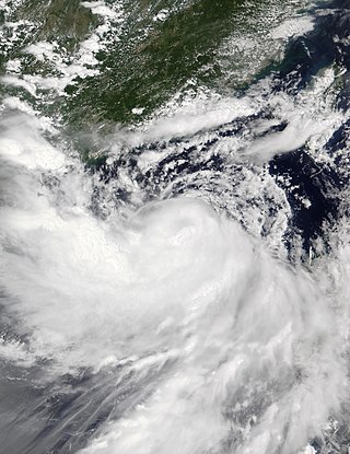
Tropical Storm Nangka, also known in the Philippines as Tropical Depression Nika, was a weak tropical cyclone which impacted Hainan and parts of Indochina, which had been affected by Tropical Storm Linfa just days earlier. Nangka in total caused 4 deaths and 5 missing in China and Vietnam.

<span class="mw-page-title-main">Typhoon Goni</span> Pacific typhoon in 2020

Typhoon Goni, known in the Philippines as Super Typhoon Rolly, was an extremely powerful tropical cyclone that made landfall as a Category 5 equivalent super typhoon on Catanduanes in the Philippines, and in Vietnam as a tropical storm. It was the strongest landfalling tropical cyclone on record by 1-minute maximum sustained winds. The name "Goni" which means swan in Korean. The nineteenth named storm, ninth typhoon, and second super typhoon of the 2020 Pacific typhoon season, Goni originated as a tropical depression south portion of Guam on October 26. It was then named as Tropical Storm Goni on October 27. On the next day, Goni explosively intensified over the Philippine Sea, becoming a Category 5–equivalent super typhoon on October 30. Goni maintained Category 5 strength for over a day, before making landfall on Catanduanes at peak intensity, with 10-minute sustained winds of 220 km/h (135 mph), and 1-minute sustained winds of 315 km/h (195 mph), with a minimum central pressure of 905 hPa. It was the most intense tropical cyclone observed worldwide in 2020.

<span class="mw-page-title-main">Typhoon Noru</span> Pacific typhoon in 2022

Typhoon Noru, known in the Philippines as Super Typhoon Karding, was an intense and destructive tropical cyclone that affected Vietnam, Thailand, and the Philippines — where it caused widespread agricultural damage. Noru, which means Roe deer in Korean, the sixteenth named storm and eighth typhoon, and third super typhoon of the 2022 Pacific typhoon season, Noru originated from a disturbance over the Philippine Sea, slowly tracking eastward until its development into a tropical depression, where it began to move westward.

<span class="mw-page-title-main">Tropical Storm Conson (2021)</span> Pacific severe tropical storm in 2021

Severe Tropical Storm Conson, known in the Philippines as Typhoon Jolina, was a strong tropical cyclone that impacted the central Philippines and Vietnam during the 2021 Pacific typhoon season. Being the thirteenth named storm of the said event, Conson originated as a low-pressure area first monitored approximately 500 km (310 mi) west of Guam. It formed as a tropical depression over the Pacific Ocean on September 5, 2021. As it formed within the Philippine Area of Responsibility, the Philippine Atmospheric, Geophysical, and Astronomical Services Administration (PAGASA) named the storm Jolina. Over the next day, it intensified into a tropical storm and was named Conson by the Japan Meteorological Agency (JMA). As the storm neared Samar Island, it intensified into a severe tropical storm, and later into a typhoon according to the PAGASA prior to its first landfall in Eastern Samar. The storm retained its strength as it crossed Visayas and later Calabarzon before weakening over Manila Bay prior to its final landfall in Bataan. It subsequently emerged into the South China Sea where it struggled to reintensify further. It then weakened into a tropical depression just offshore of Vietnam before moving ashore near Da Nang. It then rapidly weakened before dissipating on September 13.

<span class="mw-page-title-main">Tropical Storm Ma-on</span> Pacific severe tropical storm in 2022

Severe Tropical Storm Ma-on, known in the Philippines as Severe Tropical Storm Florita, was a tropical cyclone that impacted the Philippines in August 2022. The ninth named storm of the 2022 Pacific typhoon season, Ma-on originated as a disturbance over in the Pacific Ocean on August 18, and was upgraded to a tropical depression during the next day. The depression strengthened into a tropical storm receiving the name Ma-on, and became a severe tropical storm late on August 23 before making landfall in the Philippines. It would later make landfall in China and Vietnam on August 25. Ma-on weakened back to a tropical depression and due to unfavorable conditions it dissipated on August 26, 2022.

<span class="mw-page-title-main">Tropical Storm Nalgae</span> Pacific severe tropical storm in 2022

Severe Tropical Storm Nalgae, known in the Philippines as Severe Tropical Storm Paeng, was a very large and deadly tropical cyclone that wreaked havoc across the Philippines and later impacted Hong Kong and Macau. Nalgae, meaning wing in Korean, the twenty-second named storm of the 2022 Pacific typhoon season, Nalgae originated from an invest located east of the Philippines on October 26. The disturbance, initially designated as 93W, was eventually upgraded the following day to a tropical depression by the Joint Typhoon Warning Center (JTWC) and re-designated as 26W. The Japan Meteorological Agency (JMA) however, had already considered the disturbance as a tropical depression a day prior to JTWC's; the Philippine Atmospheric, Geophysical and Astronomical Services Administration (PAGASA) also followed the JMA's lead and gave it the name Paeng. That same day, it was upgraded again by the JMA to tropical storm status, thus gaining the name Nalgae. The next day, the PAGASA and the JTWC upgraded Nalgae to a severe tropical storm status on October 28. Nalgae would eventually made its first landfall in Virac, Catanduanes, which was quickly followed by another landfall thirty minutes later. It then traversed the Bicol Region and emerged into Ragay Gulf, eventually making another landfall. Defying initial forecasts, Nalgae then moved southwestward and struck Mogpog. Afterwards, the storm moved northwestward into the Sibuyan Sea and struck Sariaya. Then it would move through many regions throughout the evening of October 29. Nalgae emerged over the West Philippine Sea the next day and weakened below tropical storm status. The storm would later re-intensify into a severe tropical storm a few hours later, and eventually exited the Philippine Area of Responsibility a day later. Upon its exit from Philippine jurisdiction, Nalgae then intensified into a Category 1-equivalent typhoon on JTWC; however, the JMA maintained its severe tropical storm classification for the system. It then approached the Pearl River Delta. At around 04:50 CST on November 3, 2022, Nalgae made its final landfall at Xiangzhou District as a tropical depression.

References

  1. RSMC Tokyo - Typhoon Center. "List of names for tropical cyclones adopted by the Typhoon Committee for the western North Pacific Ocean and the South China Sea". Japan Meteorological Agency. Archived from the original on 2009-12-12. Retrieved 2006-10-08.
  2. 1 2 3 "Typhoon, flood claim 71 lives in central Vietnam". ReliefWeb. Xinhua News Agency. 2006-10-06. Retrieved 2006-10-08.
  3. 1 2 Government of the Philippines (2006-10-04). "NDCC media update effects of Typhoon "Milenyo" (Xangsane) - 04 Oct 2006". ReliefWeb. Retrieved 2006-10-09.
  4. Viet Bao (2006-10-01). "48 người chết vì bão Xangsane - 01 Oct 2006". Viet Bao Viet Nam. Archived from the original on 2013-04-21. Retrieved 2006-10-19.
  5. 1 2 3 4 5 6 7 Boyle, Kevin. "Typhoon Xangsane: 25 September – 2 October". Typhoon2000. Retrieved 2014-10-13.
  6. 1 2 3 4 5 6 7 8 9 10 Annual Report on Activities of the RSMC Tokyo: Typhoon Center 2006 (PDF) (Report). Japan Meteorological Agency. p. 38. Retrieved 2014-10-13.
  7. 1 2 3 4 5 6 "JTWC Best Track for Typhoon 18W (Xangsane)". Joint Typhoon Warning Center. 2007. Archived from the original on 2011-06-07. Retrieved 2014-10-13.
  8. 18W Xangsane: 09/27/06 0830z GMS-6 VIS (jpg). United States Naval Research Laboratory. 2006-09-27. Retrieved 2014-10-14.
  9. 1 2 Joint Typhoon Warning Center (2006-09-29). "Prognostic Reasoning for Tropical Storm 18W Warning NR 15" . Retrieved 2014-10-13.
  10. 1 2 Joint Typhoon Warning Center (2006-09-30). "Prognostic Reasoning for Tropical Storm 18W Warning NR 19" . Retrieved 2014-10-13.
  11. National Climatic Data Center (2010). 2006 Chanchu (2006128N09138). The International Best Track Archive for Climate Stewardship (IBTrACS): Unifying tropical cyclone best track data (Report). Bulletin of the American Meteorological Society. Archived from the original on November 22, 2015. Retrieved 2014-10-14.
  12. "NAIA shuts down, flights cancelled". Manila Times . 2006-09-29. Archived from the original on 2006-10-03. Retrieved 2006-10-10.
  13. "Milenyo could hit Metro Manila - PAGAS". INQ7. 2006-09-27. Retrieved 2006-10-07.
  14. PAGASA (2006-09-28). "Severe weather bulletin - number 12". ReliefWeb. Retrieved 2006-10-07.
  15. "Over 180,000 people must evacuate to avoid Xangsane". VietNamNet. 2006-09-30. Archived from the original on 2007-09-11. Retrieved 2006-11-04.
  16. "Xangsane forecast to hit large area". VietNamNet. 2006-09-29. Archived from the original on 2006-10-26. Retrieved 2006-10-07.
  17. "Typhoon prompts Vietnam Airlines to cancel night flights". VietNamNet. 2006-10-01. Archived from the original on 2006-10-26. Retrieved 2006-11-04.
  18. "Vietnam cleans up after deadly typhoon". ReliefWeb. Agence France-Presse. 2006-10-02. Retrieved 2006-10-07.
  19. United Nations Office for the Coordination of Humanitarian Affairs (2006-10-03). "The Philippines, Vietnam and Thailand: Typhoon OCHA Situation Report No. 2". ReliefWeb. Retrieved 2006-10-07.
  20. 1 2 3 Cruz Roja Española (2006-10-03). "The Red Cross sends emergency equipment to support the victims of Typhoon Milenio (Spanish)". ReliefWeb. Retrieved 2006-10-08.
  21. 1 2 Rivera, Blanche (2006-09-29). "Typhoon batters Metro Manila, Bicol". INQ7. Retrieved 2006-10-08.
  22. Ivan, Mark; et al. (2006-09-28). "'Milenyo' slams into RP; Metro Manila in its path". Manila Times . Archived from the original on 2006-10-03. Retrieved 2006-10-10.
  23. "Philippines still assessing damage from typhoon Xangsane". ReliefWeb. Agence France-Presse. 2006-10-04. Retrieved 2006-10-09.
  24. International Federation of Red Cross and Red Crescent Societies (2006-10-02). "Philippines: Typhoon Xangsane Emergency Appeal No. MDRPH002". ReliefWeb. Retrieved 2006-10-09.
  25. "Typhoon Xangsane, flood toll reaches 169". ReliefWeb. Reuters. 2006-10-05. Retrieved 2006-10-08.
  26. Long, Le Thang (2006-10-03). "Vietnamese villagers struggle after typhoon". ReliefWeb. Agence France-Presse. Retrieved 2006-10-08.
  27. 1 2 International Federation of Red Cross and Red Crescent Societies (2006-10-04). "Viet Nam: Typhoon Xangsane Emergency Appeal No. MDRVN001". ReliefWeb. Retrieved 2006-10-08.
  28. 1 2 3 International Federation of Red Cross And Red Crescent Societies (2006-10-04). "Thailand: Floods Information Bulletin No. 1". ReliefWeb. Retrieved 2006-10-08.
  29. "More flood deaths, water borne disease alert". MCOT. 2006-10-03. Archived from the original on 2006-10-09. Retrieved 2006-10-08.
  30. http://cidi.org/disaster/06b/ixl118.html%5B%5D
  31. "Ang Thong inundated". The Nation. 2006-10-03. Archived from the original on 2006-10-30. Retrieved 2006-10-09.
  32. 1 2 International Federation of Red Cross and Red Crescent Societies (2006-10-03). "International Federation launches emergency appeal as the Philippines faces another violent storm". ReliefWeb. Retrieved 2006-10-09.
  33. Ager, Maila (2006-10-02). "Senator, solon seek permanent billboard ban". INQ7. Retrieved 2006-10-09.
  34. Nguoi chet
  35. "ESCAP/WMO台风委员会第三十九次届会在菲律宾召开]" [The 39th session of the ESCAP/WMO Typhoon Committee was held in the Philippines] (in Chinese). Archived from the original on 2007-01-03.
  36. "Typhoon Committee adopt new typhoon name". China Meteorological Agency. 2007. Archived from the original on December 8, 2007. Retrieved 2007-12-11.
  37. "Philippine Tropical Cyclone Names". Philippine Atmospheric, Geophysical and Astronomical Services Administration. Archived from the original on 2015-02-01. Retrieved 2015-02-01.