
Typhoon Talim, known in the Philippines as Typhoon Isang, was a strong tropical cyclone that passed over Taiwan on the night of August 31 to September 1, 2005, and over Southeast China on September 2. At peak intensity, Talim was a Category 4 super typhoon. The name of the typhoon comes from the Tagalog term talim, which means "a sharp or cutting edge".

The 2007 Pacific typhoon season was a below average season which featured 24 named storms, fourteen typhoons, and five super typhoons. It was an event in the annual cycle of tropical cyclone formation, in which tropical cyclones form in the western Pacific Ocean. The season ran throughout 2007, though most tropical cyclones typically develop between May and November. The season's first named storm, Kong-rey, developed on March 30, while the season's last named storm, Mitag, dissipated on November 27. The season's first typhoon, Yutu, reached typhoon status on May 18, and became the first super typhoon of the year on the next day.

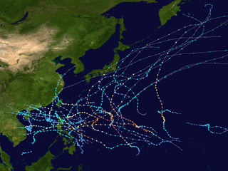
The 2001 Pacific typhoon season was the fourth and final consecutive year with below-average activity, making it the lowest four-year period of activity since 1976–1979, due to the presence of a strong La Niña that had persisted from 1998–2001. The season produced twenty-five named storms, sixteen typhoons and three super typhoons. It ran year-round in 2001, with most tropical cyclones in the northwestern Pacific Ocean tending between May and November.

The 1988 Pacific typhoon season had no official bounds; it ran year-round in 1988, but most tropical cyclones tend to form in the northwestern Pacific Ocean between May and November. These dates conventionally delimit the period of each year when most tropical cyclones form in the northwestern Pacific Ocean. Tropical Storms formed in the entire west Pacific basin were assigned a name by the Joint Typhoon Warning Center. Tropical depressions that enter or form in the Philippine area of responsibility are assigned a name by the Philippine Atmospheric, Geophysical and Astronomical Services Administration or PAGASA. This can often result in the same storm having two names.

The 1987 Pacific typhoon season has no official bounds; it ran year-round in 1987, but most tropical cyclones tend to form in the northwestern Pacific Ocean between May and November. These dates conventionally delimit the period of each year when most tropical cyclones form in the northwestern Pacific Ocean. Tropical storms formed in the entire west pacific basin were assigned a name by the Joint Typhoon Warning Center. Tropical depressions that enter or form in the Philippine area of responsibility are assigned a name by the Philippine Atmospheric, Geophysical and Astronomical Services Administration or PAGASA. This can often result in the same storm having two names.
The 2009 Pacific typhoon season was a below average season that spawned only 22 named storms, 13 typhoons, and five super typhoons. It was also recognized as the deadliest season in the Philippines for decades. The first half of the season was very quiet whereas the second half of the season was extremely active. The season's first named storm, Kujira, developed on May 3 while the season's last named storm, Nida, dissipated on December 3.

The 2017 Pacific typhoon season was a below-average season in terms of accumulated cyclone energy and the number of typhoons and super typhoons, and the first since the 1977 season to not produce a Category 5-equivalent typhoon on the Saffir–Simpson scale. The season produced a total of 27 named storms, 11 typhoons, and only two super typhoons, making it an average season in terms of storm numbers. It was an event in the annual cycle of tropical cyclone formation, in which tropical cyclones form in the western Pacific Ocean. The season runs throughout 2017, though most tropical cyclones typically develop between May and October. The season's first named storm, Muifa, developed on April 25, while the season's last named storm, Tembin, dissipated on December 26. This season also featured the latest occurrence of the first typhoon of the year since 1998, with Noru reaching this intensity on July 23.

The 2018 Pacific typhoon season was at the time, the costliest Pacific typhoon season on record, until the record was beaten by the following year. The season was well above-average, producing 29 storms, 13 typhoons, and 7 super typhoons. It was an event in the annual cycle of tropical cyclone formation, in which tropical cyclones form in the western Pacific Ocean. The season ran throughout 2018, though most tropical cyclones typically develop between May and October. The season's first named storm, Bolaven, developed on January 3, while the season's last named storm, Man-yi, dissipated on November 28. The season's first typhoon, Jelawat, reached typhoon status on March 29, and became the first super typhoon of the year on the next day.

This timeline documents all of the events of the 2012 Pacific typhoon season, the period that tropical cyclones formed in the Western Pacific Ocean during 2012. Most of these tropical cyclones formed between May and November 2012. The scope of this article is limited to the Pacific Ocean, north of the equator between 100°E and the International Date Line. Tropical storms that form in the entire Western Pacific basin are assigned a name by the Japan Meteorological Agency (JMA). Tropical depressions that form in this basin are given a number with a "W" suffix by the United States' Joint Typhoon Warning Center (JTWC). In addition, the Philippine Atmospheric, Geophysical and Astronomical Services Administration (PAGASA) assigns names to tropical cyclones that enter or form in the Philippine area of responsibility. These names, however, are not in common use outside of the Philippines.

Typhoon Lingling, known in the Philippines as Typhoon Nanang, was a deadly typhoon that struck the Philippines and China in 2001 and caused 379 deaths. The name "Lingling" was given by Hong Kong. The 39th tropical depression, 22nd named storm, and 13th typhoon of the 2001 Pacific typhoon season, Lingling developed into a tropical depression on November 6 and given the local name Nanang by the PAGASA. The next day, it was upgraded into a tropical storm and given the name Lingling by the Japan Meteorological Agency (JMA). Lingling's intensity briefly stagnated as it moved over Visayas before resuming intensification and intensifying into a severe tropical storm on November 8. One day later, both the JMA and the Joint Typhoon Warning Center (JTWC) upgraded Lingling to a typhoon as it exited the Philippine archipelago and moved into the South China Sea. After intensifying into a typhoon, Lingling began to quickly intensify, peaking with 10-min sustained winds of 155 km/h (100 mph) and 1-min sustained winds of 215 km/h (130 mph), with a minimum central pressure of 940 mbar (27.76 inHg). Lingling began to weaken as it approached the Vietnamese coast, before making landfall on November 11 at 18:00 UTC. Lingling rapidly weakened afterward, dissipating on November 12.

Typhoon Joe, known in the Philippines as Typhoon Nitang, affected the Philippines, China, and Vietnam during July 1980. An area of disturbed weather formed near the Caroline Islands on July 14. Shower activity gradually became better organized, and two days later, the system was upgraded into a tropical depression. On July 18, the depression was classified as Tropical Storm Joe. Initially, Joe moved northwest, but began to turn to the west-northwest, anchored by a subtropical ridge to its north. Joe started to deepen at a faster clip, and attained typhoon intensity on July 19. The eye began to clear out, and the next day, Joe reached its highest intensity. Shortly thereafter, Joe moved ashore the Philippines. There, 31 people were killed and 300,000 others were directly affected. Around 5,000 homes were destroyed, resulting in an additional 29,000 homeless. Damage in the nation was estimated at $14.5 million (1980 USD).

The 2021 Pacific typhoon season was the second consecutive to have below-average tropical cyclone activity, with twenty-two named storms, and was the least active since 2011. Nine became typhoons, and five of those intensified into super typhoons. This low activity was caused by a strong La Niña that had persisted from the previous year. The season's first named storm, Dujuan, developed on February 16, while the last named storm, Rai, dissipated on December 21. The season's first typhoon, Surigae, reached typhoon status on April 16. It became the first super typhoon of the year on the next day, also becoming the strongest tropical cyclone in 2021. Surigae was also the most powerful tropical cyclone on record in the Northern Hemisphere for the month of April. Typhoons In-fa and Rai are responsible for more than half of the total damage this season, adding up to a combined total of $2.017 billion.

The 2022 Pacific typhoon season was the third consecutive season to have below-average tropical cyclone activity, with twenty-five named storms, although it was more active than the previous seasons by named storm count. Ten became typhoons, and three of those intensified into super typhoons. This low activity was caused by a unusually strong La Niña that had persisted from 2020. The season's first named storm, Malakas, developed on April 6, while the last named storm, Pakhar, dissipated on December 12. The season's first typhoon, Malakas, reached typhoon status on April 12. The season ran throughout 2022, though most tropical cyclones typically develop between May and October. Tropical storms Megi and Nalgae were responsible for more than half of the casualties, while typhoons Hinnamnor and Nanmadol both caused $1 billion in damages.

Typhoon Maggie, known in the Philippines as Typhoon Etang, was a large and powerful typhoon that affected the Philippines and southeast Asia. The sixth tropical cyclone and second typhoon of the 1999 Pacific typhoon season, Maggie developed from a monsoon trough over the Philippine Sea on June 1. Quickly intensifying to tropical storm strength the following day, Maggie followed a northward course as it continued to intensify, reaching typhoon strength at 18:00 UTC as it turned northwestward. Maggie rapidly intensified to reach its peak intensity as a Category 3 equivalent typhoon on June 5 as it passed through the Luzon Strait. The typhoon brushed Taiwan on June 6 and began to weaken, making landfall near Hong Kong as a minimal typhoon on June 7. Afterward, Maggie weakened to a tropical storm as it briefly moved offshore. The storm moved back onshore the following day and quickly weakened, degenerating into a remnant area of low pressure on June 8.
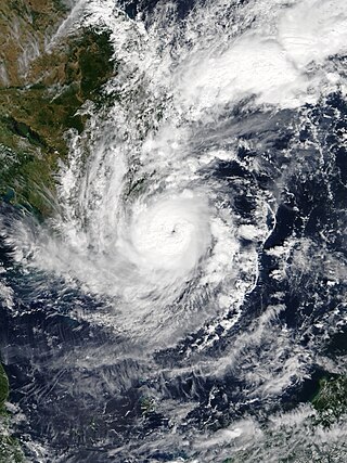
Severe Tropical Storm Usagi, known in the Philippines as Tropical Storm Samuel, was a tropical cyclone that affected the Philippines and Southern Vietnam in late November 2018, causing severe damage around the Visayas region and Ho Chi Minh City. The storm formed from a disturbance in the Central Pacific basin on November 3, but did not develop into a tropical storm until almost three weeks later, on November 13. Usagi underwent rapid intensification and peaked in intensity before making its final landfall on Vũng Tàu, Bà Rịa–Vũng Tàu province as a weakening tropical storm on November 25. While never considered as a typhoon by the Japan Meteorological Agency (JMA), the Joint Typhoon Warning Center (JTWC) assessed its intensity to be equivalent to Category 2 status on the Saffir–Simpson scale. Usagi caused one death and ₱52.2 million (US$992,000) in damages in the Philippines, most of which came from agriculture. Usagi caused 3 deaths and ₫925 billion in damages in Vietnam.

Typhoon Toraji, known in the Philippines as Typhoon Isang, was one of the deadliest tropical cyclones to hit the island country of Taiwan, since 1961. The eight named storm and the third typhoon of the 2001 Pacific typhoon season, Toraji's origins were from an area of convection that persisted to the west of Guam. Moving north-northwest over favorable conditions, the disturbance intensified to a tropical depression, while the JTWC issued a TCFA on the newly-developed system. On July 26, the depression entered the Philippine Area of Responsibility, with the PAGASA naming it Isang. Strong easterly wind shear inhibited further development; however, as the shear relaxed, both the JTWC and PAGASA upgraded the system to a tropical storm with also the JMA following suit hours later. Now named Toraji, the storm slowly intensified, reaching typhoon status on the next day. Toraji continued to gain strength until it made landfall as a Category 2 typhoon near Taipei on July 29. Despite the rugged terrains of the country, the JTWC upgraded the system further to a Category 3, shortly before weakening as it moved offshore on Taiwan Strait. The JMA and PAGASA downgraded the typhoon to a tropical storm, with the latter issuing their final advisory as it moved out of their AOR. It continued to weaken, with the JTWC also downgrading the system to a tropical storm, before making landfall near Fuzhou on July 31 before it was last noted by the next day.
Severe Tropical Storm Durian was a deadly system that caused severe impacts in China and Vietnam. The seventh tropical depression and third named storm of the 2001 Pacific typhoon season, the storm was first noted on June 29 and quickly intensified into a tropical storm and given the name Durian by the Japan Meteorological Agency (JMA). Durian continued northwestward before intensifying into a severe tropical storm as it approached the Chinese coast. On July 1 just before landfall, Durian peaked in intensity, with the JMA estimating 10-min winds of 110 km/h (70 mph) and the Joint Typhoon Warning Center (JTWC) estimating 1-min winds of 140 km/h (85 mph). Durian made landfall on Zhanjiang at peak intensity, before quickly weakening over land and dissipating on July 3 over the mountains of Vietnam.

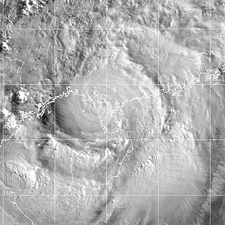
Typhoon Flo, known in the Philippines as Typhoon Kadiang, was a catastrophic and deadly minimal typhoon that hit the northern Philippines during October 1993. It also caused the largest 72-hour forecast error for the year due to its interaction with the nearby Super Typhoon Ed. The twenty-seventh depression, twenty-second named storm and the eleventh typhoon of the 1993 Pacific typhoon season, Flo originated from an area of convection that was embedded from a monsoon trough during September 28. Two days later, a tropical depression formed within this trough, to the west of Guam. Slowly organizing, it remained a tropical depression until on October 2, when it strengthened to a tropical storm and was given the name Flo by the Japan Meteorological Agency. Slight wind shear from nearby Ed inhibited development; however, it intensified to a minimal typhoon as it neared the coastline of Luzon. On October 3, it made landfall near the Isabela-Aurora in its peak. It then crossed the country while weakening, and moved ashore near the South China Sea the next morning. It then unexpectedly moved back to the country due to its interaction with Ed, and it moved back to the Philippine Sea on October 17 before accelerating to the south of Japan. It then became extratropical on the next day.

Typhoon Kyle, known in the Philippines as Typhoon Luring, was the first of five deadly tropical cyclones that affected and impacted the Philippines and Vietnam during the 1993 Pacific typhoon season. The twenty-seventh named storm and thirteenth typhoon of the season, Kyle formed from a monsoon depression near Palau, associated with bursts of scattered convection. It then drifted west-northwest, strengthening to a tropical storm the next day. Land interaction prevented further intensification, and it crossed through the central Philippines while maintaining its intensity on November 20. Upon entering the South China Sea, the system strengthened to a severe tropical storm before rapidly intensifying to a typhoon, three days later. It soon reached its peak intensity that day, with one-minute maximum sustained winds of 175 km/h (110 mph), equivalent to a mid-level Category 2 typhoon. It held its strength until landfall in Vietnam later that evening. Weakening through the mountainous terrain of the country, it dissipated near the Cambodia–Thailand border on November 24.

Typhoon Manny, known in the Philippines as Typhoon Naning, was a long-lived and deadly tropical cyclone that struck the Philippines during the 1993 Pacific typhoon season. It was the second typhoon to hit the Visayas, in the central Philippines, that year, following Kyle. The twenty-ninth named storm and fifteenth typhoon of the season, the system formed from a near-equatorial trough that also spawned Lola during the month in the east Caroline Islands on December 3. Moving northwestwards, it strengthened to a tropical storm on the next day before intensifying further to a severe tropical storm that night. The system attained typhoon status on December 8, while making an anticyclonic loop, nearly the same as Pamela, 11 years later. It then rapidly intensified while moving to the southwest, with the typhoon reaching its peak of 220 km/h (140 mph) and an unusually high barometric pressure of 960 mbar before crossing the central Philippines on December 10 and 11. It soon moved through the South China Sea as a tropical storm before weakening to a tropical depression as it encountered high wind shear. However, it restrengthened back to a tropical storm as it moved back again to a favorable environment before passing to the south of Vietnam as the system weakened back below gale-force winds. It then dissipated on December 16 as it passed through Thailand.

