Typhoon Olga (1976)

Last updated
Map key
  Tropical depression (≤38 mph, ≤62 km/h)
  Tropical storm (39–73 mph, 63–118 km/h)
  Category 1 (74–95 mph, 119–153 km/h)
  Category 2 (96–110 mph, 154–177 km/h)
  Category 3 (111–129 mph, 178–208 km/h)
  Category 4 (130–156 mph, 209–251 km/h)
  Category 5 (≥157 mph, ≥252 km/h)
  Unknown
Storm type
Disc Plain black.svg Tropical cyclone
Solid black.svg Subtropical cyclone
ArrowUp.svg Extratropical cyclone, remnant low, tropical disturbance, or monsoon depression

On May 4, the JTWC noted multiple surface circulation zones inside a trough near Micronesia. For some of its early life, this precursor circulation generally moved southwestward, although the Japan Meteorological Agency (JMA) first tracked its predecessor at 18:00 UTC of May 11 as a 1,004 hectopascals (29.6  inHg ) system. On May 12, the JTWC had issued a warning on the system, citing that one circulation had started to overtake the others. Six hours later, the disturbance made a west-northwest movement as being guided by the southern periphery of a subtropical ridge in the Pacific before the agency upgraded the system to a tropical storm on the next day in the afternoon. [1] [2]

That night, satellite imagery revealed the presence of another circulation, located 120 nautical miles (220 km; 140 mi) to the east of Olga. The new circulation interacted with the strengthening system, before the original center dissipated and its remaining convection had been absorbed by the second feature while moving west-northwest. Slowly but modest intensification prevailed over the disturbance, and the new cyclone reintensified to a tropical storm. However, both the JMA and JTWC continued tracking this system as Olga. It then inclined northwards due to a shortwave trough trailing across the westerlies on May 16 before resuming its track to the west-northwest as a result of the trough moving to the east. At this time, Olga was now tracked by the Manila Weather Bureau (now the PAGASA) as it entered the Philippine Area of Responsibility (PAR) and assigned it the local name “Didang”. [1] [2] [3] Olga subsequently entered an area of unfavorable wind shear caused by a 200 mb ridge inclined over the Southeast Asia and despite this, it slowly intensified while nearing the mainland Philippines. The cyclone also initiated a counterclockwise loop and slowed down as a result of a long-wave trough moving off the east coast of China. The system completed this loop on October 20 while continuing to slowly strengthen. Reconnaissance aircraft reports from 03:30 UTC and 19:47 UTC indicated that Olga started to underwent rapid intensification as a pressure drop of 44 mb (from 978 mb to 934 mb) were recorded. At approximately 00:00 UTC of the next day, Olga made landfall on the province of Aurora with an estimated maximum sustained winds of 185 km/h (115 mph) and a barometric pressure of 940 hectopascals (28  inHg ), making at a Category 3 typhoon. [1] [2]

Upon moving inland, Olga's winds rapidly degraded to tropical storm-force winds as it passed over Baler Bay before crossing through Central Luzon. Moving with a forward speed from 2 to 4 knots, it moved to the west-southwest, before taking a westward path. Still as a gale-force system, the cyclone turned northwest before exiting through Lingayen Gulf on May 24. It subsequently reintensified slightly before turning to the northeast, this time sparing Northern Luzon a direct hit again from the system as it passed through Batanes as it inclined north-northeast. By the next day, what was Olga is now just a low-level circulation separated through its convection while accelerating away from the typhoon-stricken Philippines. The system was last tracked by the weather bureau of the Philippines on May 26 before the final advisory was issued by the JTWC at 06:00 UTC of that day while located to the east of Hengchun in Formosa (now Taiwan). The agency also noted that the remnants of Olga were absorbed into a subtropical disturbance on May 27 to the south of Okinawa, although the JMA continued to track the system until they dropped monitoring it on 12:00 UTC of May 31 near the International Date Line. [1] [2] [3] [4]

Effects

The Philippines suffered a direct hit from Olga on May 21, when the system made landfall over Aurora. Along with the prevailing southwest monsoon over the country, the cyclone caused heavy rainfall along the Southern, Central and Northern portions of Luzon, causing catastrophic floods. Millions lost their homes due to the inundation and many reservoirs overflowed and burst due to continuous downpour, again affecting many individuals. The final death toll for the storm were at 374 while damages reached in millions of dollars. At Cubi Point, the rainfall exceeded over 50 inches (1,300 mm), which would place the system as one of the wettest tropical cyclones in the Philippines. [1] The summary of the events after the storm wrecked through the country are summarized by date [nb 1] as follows:

May 19

On May 19, before moving inland, Olga's rainbands caused heavy rains, leading to flash floods in metropolitan Manila. 8,000 in Manila were required to leave their homes and thousands of commuters were stranded. In a suburb of Caloocan, seven feet of floodwaters were seen; navy amphibious tanks were sent to evacuate people whose are in their homes to schools for their safety. As a response to this, the Philippine President at that time, Ferdinand Marcos lifted the regular 1-4 am martial law curfew to let thousands of stranded passengers go home without any fines. [5] [6] [7]

May 20

On May 20, seven deaths were further confirmed from the storm. Olga's flooding was also described as the “worst in 30 years”, according to the authorities in the Philippines. At least 10,000 individuals forced to flee their homes in Quezon City due to over 16.1 inches (410 mm) of rain, with the said amount being confirmed by Roman L. Kintinar, the chief of the Manila Weather Bureau. [nb 2] Tens of thousands of motorists and commuters were also stranded in capital Manila. Emergency safety shelters were built in several churches and schools throughout the area for the evacuees while the navy frogmen rescued 71 persons from a flooded residential area in an unknown place outside Manila. Ten persons were reported to have been missing there. Over than 1,500 persons were also trapped and affected by six-feet waters in Mandaluyong. Communications outside the metropolitan area were cut and authorities there said that no reports of damages were received as of that date in provinces that are also affected by Olga. As a result, President Marcos declared Manila and five other Luzon provinces in state of emergency and ordered all businesses in Manila and Quezon City to be closed except the essential operations. Floods came as workers in the city were reportedly finishing 25 inundation-control projects that were set up at that time.The Philippine Red Cross appealed help to USAID and local residents to the area for food supplies for the victims of the storm. [8]

May 21

The death toll further rose to 25 and 8 being missing on May 21. Sixteen of them are recovered from the rising waters on an unknown place in the country. Two light aircraft with 12 persons aboard are missing during the onslaught of the typhoon. The proclaimed state of calamity in Manila and nearby areas froze food prices and imposed penalties in hoarders and profitters there. President Marcos also ordered the Philippine Air Force to run cloud-seeding operations in the mountainous areas north of the capital to induce rainfall away from its storm clouds to populous areas. Marcos said in news reports from the Philippines that a PAF C-47 aircraft poured sodium chloride onto Olga to contain the record rainfall it brought onto the country's capital, but it did still dropped record-heavy downpour. It is based on meeting with relief and rescue officials that Marcos did the decision to declare a state of calamity in several areas in the Philippines that are severely affected from the storm. Storm signals were continued to be raised and maintained as Olga emerges onto the South China Sea. [9] [10] [11] [12]

May 22

A plane of 5 people crashed in a wooded hills 40 miles to the south of Manila from Leyte to the area. The death toll at that date were set at 35. PRC noted that reports from different provinces that are also hit hard by Olga were delayed due to broken power lines. A rescue official also informed the media in the country that bad weather also prevented the dispatch of planes to check the Seng Hong, a Panamanian-registered freighter that was reported to be run aground near Mamburao Bay, located to the south of the capital. 18 passengers were on board. The other aircraft, a Philippine navy plane that was bound for Manila from Palawan with seven passengers that was also affected by Olga. [13]

May 24

Two days later, 41 were reported dead due to Olga in the country, with the number further increasing to 47 in further reports. Three from them are from Nueva Ecija due to drowning and another three in Manila from the storm-related short circuit fire. The access roads through Manila International Airport (now Ninoy Aquino International Airport) flooded although the airport remained open for flights. In additional, communications from Manila to Zamboanga in Mindanao, where an aircraft hijacking happened on May 21 there and ended on May 24 were disrupted due to broken transmission lines in the former. [14] Ferdinand Marcos further extended the state of calamity on the main island of Luzon on May 24 as a result of the disaster. Eight hospitals in the country also suspended patient admissions due to their emergency and admitting sections being inundated by floods. Officials there informed the United Press International from Manila that the Portrero Dike, a reservoir located 90 miles to the north of Manila overflowed during the onslaught of the storm, flooding towns near the area. Nueva Ecija was almost entirely swamped, according to Marcos. The Pampanga River also overflowed as its water rose more than three yards. Further Luzon's south, railways were disrupted as a result of Olga's rains, and the damages to crops and property were described as “extensive”. Over 100,000 people were rendered homeless. As a result, Marcos ordered the Armed Forces of the Philippines (AFP) to form rescue units. [15] [16] [17] [18] [19] [20]

May 25

Aerial view of flooded section of Pampanga Province on an unknown date. Olga-flooded.png
Aerial view of flooded section of Pampanga Province on an unknown date.

With the addition of six from the existing casualty toll, the deaths from Olga's flooding rose to 53 as of the next day, May 25. In addition, Arnedo Dike, a major flood control reservoir in Pampanga also overflowed due to the system's rains. The AFP ordered the evacuation of 50,000 persons living near the foot of the said basin while a flood control station, located 40 miles to the north of Manila recorded rising two-feet floodwaters. The country's defense home center in Pampanga appealed for US water-resistant vehicles from Clark Air Base and helicopters for rescuing and evacuating stranded residents. Furthermore, they also aided in food rescue operations in many flooded areas. The municipality of La Paz in Tarlac has an estimated 10,000 people stuck in their flooded areas, according to news reports there. According to the state-owned Philippine News Agency, on that day over 10,000 families or 70,000 individuals were affected by the burst of the dike and the number of evacuated people rapidly ascended to over 139,500 as of that day. Late news reports from the country indicated that Marcos announced the state of calamity on Luzon via nationwide radio; many goods are under price freeze including candles, matches, canned goods, fish and instant coffee. Over 15,000 acres of rice lands ready for harvesting were wasted due to Olga. [21] [22]

May 26

The number of people who evacuated during the reservoir burst climbed to 80,000 on May 26. Two more waterbodies overflowed on the country due to Olga; the Santo Tomas and Santa Cruz dikes. The former destroyed 400 houses and killed eight in its path. The death toll further rose to 109 with most of them due to drowning. Over 115,588 families or 602,000 persons were also in need of help due to the storm's aftermath. The estimated damages from the typhoon were set at $70 million, according to Marcos during an emergency meeting on that day with his cabinet members. 66 towns and 4 cities in the country were flooded while 14 bridges were washed away. Damages to public infrastructures were incurred at $3.6 million. Meanwhile, combined agricultural and property damages were set at $14 million. Rice stock at the disaster was announced to be at 1.8 million tons. More than 204,000 people lost their homes as a result. Hundreds of residents who refused to evacuate climbed and perched nearby trees and rooftops for their safety, news reports there indicated. Along with UPI photographer Willy Vicoy, Philippine helicopters rescued 127 persons in Arayat, a municipality in Pampanga. A bridge in the area also collapsed, killing four due to drowning. Flood readings in the Pampanga River indicated an “all-time high” of 17.85 feet on that day also, beating the 17.5 feet record held by the same basin in a disastrous flood in July and August 1972. [23] [24] [25] [26]

40-80% of the sets at Iba, Zambales from the production of the 1979 American epic psychological war film Apocalypse Now were also wrecked due to strong winds from Olga. Its stranded crew were confined in a hotel and others were in small houses. The Playboy Playmate set had been also destroyed, ruining a month's production schedule. [27]

May 27

112 individuals were further reported dead and 12 missing on May 27. Destroyed bridges caused by flooding disrupted aid to over 600,000 people affected by the storm. American and Filipino helicopters continue to rescue people that are still stranded off their roofs. Meanwhile, 1 dam, 10 dikes, 20 bridges, and 92 areas in the Philippines were affected, destroyed, or sustained damages due to Olga. The MacArthur Highway was reported to have been cut due to floods. As a response to the appeal from the Philippine government, the U.S. government sent Navy and Air Force helicopters to assist the existing rescue operations. Despite Olga now in the South China Sea, it influenced the southwest monsoon with its “tail” causing another round of downpour in downtown Manila. It caused heavy traffic in and out of the capital while vehicles were also stranded due to numerous landslides in Baguio. The Santo Tomas Dam, a reservoir that overflowed on May 26 killed 82 in Batangas, late reports indicated. 20 passengers in a bus were also swept away into their deaths, according to a radio report from the government of Bicol Region where the accident happened. Despite these, businesses in Manila were opened after five days of closure while several thousands of passenger ferries and vessels were still in shelters and stranded in Mindoro Island, in which most of them were bound to the capital. [28] [29] [30]

May 28

"The floodwaters are receding very, very slowly. It may take four or five days before the floods recede.”

A spokesperson from the National Disaster Control Center (NDCC) [31]

185 people were killed and over 800,000 were rendered homeless as of May 28. 10 of the latest casualty toll is from Nueva Ecija, which are all students, where they are buried alive by a landslide. The Philippine Red Cross called this “the extent of human suffering and destruction” due to Olga's swath of damages. President Marcos will take an aerial survey on an unknown date in Central Luzon, according to Associated Press. Despite Olga dissipating as it was absorbed by a subtropical disturbance at this day, heavy rains occurred in Pangasinan; these are attributed to the storm. [32] [31]

May 29

"Landslides have cut off villages. Roads and bridges are destroyed. You cannot go any place by road. For miles and miles there is only water and that’s all. In one town north of Manila, Calumpit, the water is still up to the roof of the school”

Jean Michel Goudstekker, a French representative from the League of Red Cross Societies (LRCS) as she conducted a helicopter aerial tour of Central Luzon [33]

On May 29, at least 1,000 persons or over 100 vehicles were trapped in Dalton Pass in the Caraballo Mountains; military helicopters were trying to reach the area but were unsuccessful due to bad weather. 1.3 million people were also forced to leave their homes according to agencies in the area. A total of 72 flights have been already conducted by the aircraft of the U.S. Navy Force, the U.S. Navy said from Subic Bay, according to Associated Press. The Philippine Red Cross also noted that Japan, Canada, Finland, Great Britain, Australia, and New Zealand had responded to the appeal they made for help, either receiving cash or relief goods as a donation. More contributions came from the United States, Norway, and West Germany as the day ended; the former had the biggest in the countries listed below, with over $500,000 worth of donations for relief operations by the two American military bases in the country. The PRC, meanwhile published a casualty toll of 188 that day. The individuals who lost their homes were currently living in various schools, town halls, and churches, according to the organization. inundations were reported to have been receding starting that day, and the weather bureau urged people to resume their normal activities today. Marcos also finished his tour on the severely affected areas in Luzon on May 28. He also ordered a large shift from rescue operations to relief and rehabilitation routines to make the transmission of goods in the affected areas. In addition, the President also announced the cancellation of a grand parade and traditional reception that was supposed to be held on June 12, the country's independence day due to the reason that “there’s nothing to be happy about”. [33] [34]

May 31

The death toll further rose to 203 on May 31, according to the latest tally of the PRC at that day, including 5 individuals whose died of starvation due to them being trapped in a mountain pass isolated by landslides. Sixteen choppers from the Philippine and U.S. Navy rescued all the 1,000 people whose isolated over the Dalton Pass; several motorists are still stranded over the Cagayan Valley highway stretch due to destroyed and faded roads. 67 individuals meanwhile were arrested with charges of profiteering and hoarding of food packs. The Philippine President also announced the one-week cancelation of school year that was supposed to start on June 7. [35]

Post-May 1976 and retirement

8 more people were found dead, with 7 of them being buried in a landslide, increasing Olga's death toll to 211. [36]

The official death toll for the system is published at 374, according to the figure released by the now-PAGASA. [37] However, the USAID and the JTWC only agreed at the number of over 200. [38] [1] Later, the weather bureau retired the Philippine name “Didang” and was replaced with “Ditang” for future seasons. [39]

Notes

  1. These are summarized by the date of newspaper wherein the information about the impacts of Olga were published.
  2. Now the PAGASA.

See also

Related Research Articles

<span class="mw-page-title-main">2000 Pacific typhoon season</span> Typhoon season in the Western Pacific Ocean

The 2000 Pacific typhoon season marked the first year using names contributed by the World Meteorological Organization. It was a rather below-average season, producing a total of 23 tropical storms, 13 typhoons and 4 intense typhoons. The season ran throughout 2000, though typically most tropical cyclones develop between May and October. The season's first named storm, Damrey, developed on May 7, while the season's last named storm, Soulik, dissipated on January 4 of the next year.

<span class="mw-page-title-main">1964 Pacific typhoon season</span> Typhoon season in the Pacific Ocean

The 1964 Pacific typhoon season was the most active tropical cyclone season recorded globally, with a total of 39 tropical storms forming. It had no official bounds; it ran year-round in 1964, but most tropical cyclones tend to form in the northwestern Pacific Ocean between June and December. These dates conventionally delimit the period of each year when most tropical cyclones form in the northwestern Pacific Ocean.

<span class="mw-page-title-main">Typhoon Nina (1987)</span> Pacific typhoon in 1987

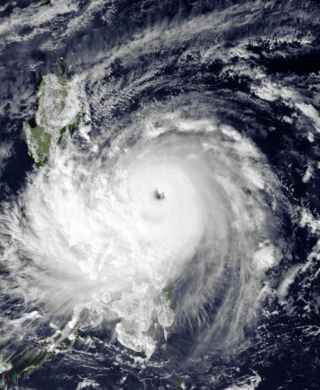
Typhoon Nina, known in the Philippines as Typhoon Sisang, was the most intense typhoon to strike the Philippines since Typhoon Irma in 1981. Typhoon Nina originated from an area of convection near the Marshall Islands in mid-November 1987. It gradually became better organized, and on November 19, was first classified as a tropical cyclone. Moving west-northwest, Nina attained tropical storm intensity that evening. Late on November 20, Nina passed through the Chuuk Lagoon in the Federated States of Micronesia. After a brief pause in intensification, Nina intensified into a typhoon on November 22. Two days later, the typhoon intensified suddenly, before attaining its peak 10 minute intensity of 165 km/h. During the afternoon of November 25, Nina moved ashore in Southern Luzon at the same intensity. It gradually weakened over land, before entering the South China Sea and turning to the north. By November 30, Nina dissipated.

<span class="mw-page-title-main">Typhoon Babs (1998)</span> Pacific typhoon in 1998

Typhoon Babs, known in the Philippines as Typhoon Loleng, was a powerful typhoon that struck the Philippines days after Typhoon Zeb hit the same area. The seventh typhoon of the inactive 1998 Pacific typhoon season, Babs formed on October 14 between the Philippines and Guam. The storm moved westward initially, failing to intensify initially due to the outflow from Typhoon Zeb to the northwest. Babs slowed and briefly turned to the south before advancing to the northwest, whereupon it rapidly intensified into a strong typhoon. On October 20, the official Japan Meteorological Agency (JMA) estimated peak 10‑minute winds of 155 km/h (96 mph), while the unofficial Joint Typhoon Warning Center (JTWC) estimated peak 1‑minute winds of 250 km/h (160 mph), making Babs an unofficial super typhoon. The storm struck the Philippine island of Catanduanes at that intensity and weakened slightly before hitting Luzon. Babs turned northward once in the South China Sea, later weakening due to unfavorable conditions and transitioning into an extratropical cyclone on October 27 in the Taiwan Strait.

<span class="mw-page-title-main">Typhoon Irma (1981)</span> Pacific typhoon in 1981

Typhoon Irma, known in the Philippines as Typhoon Anding, was a powerful typhoon that struck the Philippines in November 1981. The twenty-fifth named storm and fourteenth typhoon of the 1981 Pacific typhoon season, Irma originated from an active monsoon trough to the east of the Philippines. Following an increase in organization, the system was first classified on November 18 and was subsequently upgraded into a tropical storm on the next day as it moved westward. After passing near Guam, Irma continued to deepen, and was estimated to have attained typhoon intensity early on November 21. The intensification rate accelerated thereafter, and on the afternoon of November 22, Irma reached its peak wind speed of 205 km/h (125 mph). After maintaining this intensity for 16 hours, Irma weakened considerably due to interaction with the mountainous terrain of the Philippines. On the morning of November 24, Irma moved ashore northeast of Manila, with winds of 165 km/h (105 mph). The storm rapidly deteriorated overland, but was still believed to have been a typhoon when it emerged into the South China Sea. Irma then began to re-curve towards the northwest while weakening; the cyclone was estimated to have obtained extratropical characteristics on November 26.

<span class="mw-page-title-main">Typhoon Xangsane</span> Pacific typhoon in 2006

Typhoon Xangsane, known in the Philippines as Typhoon Milenyo, was a typhoon that affected the Philippines, Vietnam, and Thailand during the 2006 Pacific typhoon season. The name Xangsane was submitted by Laos and means elephant.

<span class="mw-page-title-main">Tropical Storm Halong (2008)</span> Pacific severe tropical storm in 2008

Severe Tropical Storm Halong, known in the Philippines as Typhoon Cosme, was the fourth severe tropical storm named by the Japan Meteorological Agency (JMA), which is the Regional Specialized Meteorological Centre for the Northwestern Pacific Ocean. The Joint Typhoon Warning Center also recognized Halong as the fifth tropical depression, the fourth tropical storm, as well as the third typhoon of the 2008 Pacific typhoon season.

<span class="mw-page-title-main">Typhoon Ketsana</span> Pacific typhoon in 2009

Typhoon Ketsana, known in the Philippines as Tropical Storm Ondoy, was the second-most devastating tropical cyclone of the 2009 Pacific typhoon season, causing $1.15 billion in damages and 665 fatalities, only behind Morakot earlier in the season, which caused 789 deaths and damages worth $6.2 billion. Ketsana was the sixteenth tropical storm, and the eighth typhoon of the season. It was the most devastating tropical cyclone to hit Manila, surpassing Typhoon Patsy (Yoling) in 1970.

<span class="mw-page-title-main">Typhoon Nalgae (2011)</span> Pacific typhoon in 2011

Typhoon Nalgae, known in the Philippines as Typhoon Quiel, was a powerful tropical cyclone that struck the Philippines, and it affected Hainan, China as a weak tropical storm. Nalgae was the eighth typhoon and the fourth super typhoon in 2011. Forming as the 32nd tropical depression of the season, the system formed on September 26 over the Philippine Sea. On September 27, it was named Nalgae as it explosively intensified into a typhoon on the next day. Nalgae reached its peak intensity as a Category 4 typhoon on September 30 while it made landfall over Luzon. Nalgae weakened into a tropical storm as it entered the South China Sea on October 1. Nalgae made landfall over the island of Guandong in China on October 4 as it weakened to a tropical depression. Nalgae dissipated on October 5 east of Vietnam.

<span class="mw-page-title-main">Typhoon Gordon</span> Pacific typhoon in 1989

Typhoon Gordon, known in the Philippines as Typhoon Goring, was a powerful tropical cyclone that caused widespread damage and loss of life in the Philippines and Southern China in July 1989. Gordon developed into a tropical depression near the Northern Mariana Islands on July 9 and quickly intensified as it tracked west-southwestward. On July 13, the storm attained typhoon status and subsequently underwent a period of rapid intensification. By July 15, the storm attained its peak strength as a Category 5 equivalent super typhoon with winds estimated at 260 km/h (160 mph). After striking the northern Philippines, Gordon moved through the South China Sea and slowly weakened. On July 18, the storm made landfall in southern China and was last noted the following day as it dissipated over land.

<span class="mw-page-title-main">Tropical Storm Lucille</span> Pacific tropical storm in 1960

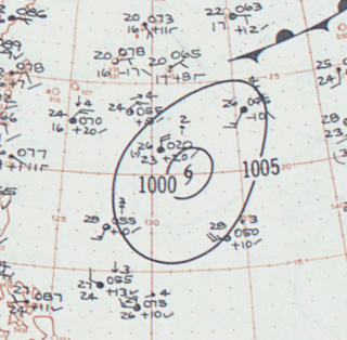
Tropical Storm Lucille was the first tropical cyclone to have its name retired in the Western Pacific basin. Lucille was identified as a weak tropical depression on May 25, 1960, to the east of the Philippines. Tracking northwestward, the system failed to develop and warnings on it were discontinued on May 27. At the same time, a second system began organizing along the west coast of Luzon. The two systems ultimately merged into one over the Philippines between May 28 and 29. Now tracking northeastward, the system re-intensified and became a tropical storm on May 30. Lucille attained its peak intensity later that day with winds of 85 km/h (53 mph). As it accelerated over open waters, the system brushed the islands of Iwo Jima and Chichi-jima before transitioning into an extratropical cyclone on June 1. The remnants of Lucille were last noted on June 4 near the International Date Line.

<span class="mw-page-title-main">Tropical Storm Rumbia (2000)</span> Pacific tropical storm in 2000

Tropical Storm Rumbia, known in the Philippines as Tropical Storm Toyang, brought deadly flooding to the central and southern Philippines in November and December 2000. The last of three consecutive tropical cyclones of at least tropical storm intensity to strike the Philippines, Rumbia began as a tropical depression on November 27, gradually intensifying to reach tropical storm intensity the next day. Strengthening later stagnated, and Rumbia would weaken back to depression status as it made landfall on the central Philippines on December 1. Though the Japan Meteorological Agency (JMA) determined Rumbia to have dissipated on December 2, the Joint Typhoon Warning Center (JTWC) continued to monitor the system over the next few days as it tracked across the South China Sea. For a period of time beginning on December 5, Rumbia reorganized and strengthened back to tropical storm intensity before wind shear began to weaken the system. Located south of Vietnam on December 7, the storm's circulation center became devoid of convection, and by then Rumbia was declared by the JTWC to have dissipated.

<span class="mw-page-title-main">Effects of the 2013 Pacific typhoon season in the Philippines</span>

The effects of the 2013 Pacific typhoon season in the Philippines were considered some of the worst in decades. Throughout the year, a series of typhoons impacted the country, with the worst impacts coming from Typhoon Haiyan, especially in death toll, during November.

<span class="mw-page-title-main">Typhoon Cary (1987)</span> Pacific typhoon in 1987

Typhoon Cary, known as Typhoon Ising in the Philippines, was the second of two tropical cyclones to affect Vietnam in a week. An area of disturbed weather developed southwest of Pohnpei on August 6, 1987. The system initially remained disorganized, but by August 14, Cary had attained tropical storm intensity. After initially moving north-northwest, Cary turned west-northwest, although intensification was slow to occur. On August 15, Cary was upgraded into a typhoon, and on August 17, the typhoon peaked in intensity. Typhoon Cary then made landfall in northern Luzon while at peak intensity. Across the Philippines, 954 houses were damaged and an additional 89 were destroyed, which left 55,567 people, or 13,247 families that were either homeless or otherwise sought shelter. Five people died in the country while damage totaled $5.58 million (1987 USD), including $1.45 million from agriculture and $4.13 million from infrastructure. The storm weakened over land, but re-intensified into a typhoon over the South China Sea. On August 21, Typhoon Cary passed just south of Hainan, where hundreds of homes were damaged but no fatalities occurred, and subsequently entered the Gulf of Tonkin. The storm weakened as it approached Vietnam, and on August 23, the storm dissipated inland over Laos. Across Vietnam, almost 40,000 ha of land were flooded or destroyed. Twenty people were killed and many others were injured.

<span class="mw-page-title-main">Typhoon Phanfone</span> Pacific typhoon in 2019

Typhoon Phanfone, known in the Philippines as Typhoon Ursula, was a strong and deadly tropical cyclone which traversed the Philippines on Christmas Eve and Christmas Day in 2019, the first typhoon to do so since Nock-ten in 2016.

<span class="mw-page-title-main">Tropical Storm Sarika (2011)</span> Pacific tropical storm in 2011

Tropical Storm Sarika, known in the Philippines as Tropical Storm Dodong, was a weak but costly tropical storm that affected Philippines and the East China in early-June 2011. The sixth tropical depression and the third named storm of the 2011 Pacific typhoon season, Sarika formed from an area of low pressure near Cebu City. As it traversed the Verde Island Passage on June 8, both the JTWC and the JMA started issuing advisories on the system, with the former issuing a TCFA on the system later that day. The next day, the PAGASA upgraded the low-pressure area to a tropical depression, naming it Dodong. Moving to the north, the system struggled to intensify due to strong wind shear and was downgraded by the JTWC to a tropical depression; however, the JMA kept the system as a minimal tropical storm until it made landfall near Shantou on June 11. It dissipated soon thereafter.

<span class="mw-page-title-main">Typhoon Flo (1993)</span> Pacific typhoon in 1993

Typhoon Flo, known in the Philippines as Typhoon Kadiang, was a catastrophic and deadly minimal typhoon that hit the northern Philippines during October 1993. It also caused the largest 72-hour forecast error for the year due to its interaction with the nearby Super Typhoon Ed. The twenty-seventh depression, twenty-second named storm and the eleventh typhoon of the 1993 Pacific typhoon season, Flo originated from an area of convection that was embedded from a monsoon trough during September 28. Two days later, a tropical depression formed within this trough, to the west of Guam. Slowly organizing, it remained a tropical depression until on October 2, when it strengthened to a tropical storm and was given the name Flo by the Japan Meteorological Agency. Slight wind shear from nearby Ed inhibited development; however, it intensified to a minimal typhoon as it neared the coastline of Luzon. On October 3, it made landfall near the Isabela-Aurora in its peak. It then crossed the country while weakening, and moved ashore near the South China Sea the next morning. It then unexpectedly moved back to the country due to its interaction with Ed, and it moved back to the Philippine Sea on October 17 before accelerating to the south of Japan. It then became extratropical on the next day.

<span class="mw-page-title-main">Typhoon Noru</span> Pacific typhoon in 2022

Typhoon Noru, known in the Philippines as Super Typhoon Karding, was an intense and destructive tropical cyclone that affected Vietnam, Thailand, and the Philippines — where it caused widespread agricultural damage. Noru, which means Roe deer in Korean, the sixteenth named storm and eighth typhoon, and third super typhoon of the 2022 Pacific typhoon season, Noru originated from a disturbance over the Philippine Sea, slowly tracking eastward until its development into a tropical depression, where it began to move westward.

<span class="mw-page-title-main">Typhoon Trix</span> Pacific typhoon in 1952

Typhoon Trix was a devastating and deadly tropical cyclone of the 1952 Pacific typhoon season that severely impacted the Philippines and also affected the coast of Indochina, particularly Vietnam. As the eighteenth storm and twelfth typhoon of the season, Trix formed on October 15 as a tropical depression over Micronesia, being first tracked by the Joint Typhoon Warning Center (JTWC). Trix slowly strengthened as it moved westwards, before it rapidly intensified as it neared the Philippines. Slight weakening took place before the system passed over the country before restrengthening in the South China Sea. There, Trix degraded again for the second time and moved over Vietnam as a tropical storm before dissipating over Thailand.

<span class="mw-page-title-main">Tropical Storm Nalgae</span> Pacific severe tropical storm in 2022

Severe Tropical Storm Nalgae, known in the Philippines as Severe Tropical Storm Paeng, was a very large and deadly tropical cyclone that wreaked havoc across the Philippines and later impacted Hong Kong and Macau. Nalgae, meaning wing in Korean, the twenty-second named storm of the 2022 Pacific typhoon season, Nalgae originated from an invest located east of the Philippines on October 26. The disturbance, initially designated as 93W, was eventually upgraded the following day to a tropical depression by the Joint Typhoon Warning Center (JTWC) and re-designated as 26W. The Japan Meteorological Agency (JMA) however, had already considered the disturbance as a tropical depression a day prior to JTWC's; the Philippine Atmospheric, Geophysical and Astronomical Services Administration (PAGASA) also followed the JMA's lead and gave it the name Paeng. That same day, it was upgraded again by the JMA to tropical storm status, thus gaining the name Nalgae. The next day, the PAGASA and the JTWC upgraded Nalgae to a severe tropical storm status on October 28. Nalgae would eventually made its first landfall in Virac, Catanduanes, which was quickly followed by another landfall thirty minutes later. It then traversed the Bicol Region and emerged into Ragay Gulf, eventually making another landfall. Defying initial forecasts, Nalgae then moved southwestward and struck Mogpog. Afterwards, the storm moved northwestward into the Sibuyan Sea and struck Sariaya. Then it would move through many regions throughout the evening of October 29. Nalgae emerged over the West Philippine Sea the next day and weakened below tropical storm status. The storm would later re-intensify into a severe tropical storm a few hours later, and eventually exited the Philippine Area of Responsibility a day later. Upon its exit from Philippine jurisdiction, Nalgae then intensified into a Category 1-equivalent typhoon on JTWC; however, the JMA maintained its severe tropical storm classification for the system. It then approached the Pearl River Delta. At around 04:50 CST on November 3, 2022, Nalgae made its final landfall at Xiangzhou District as a tropical depression.

References

  1. 1 2 3 4 5 6 "Annual Typhoon Report 1976" (PDF). Joint Typhoon Warning Center. pp. 28–29. Retrieved 2021-10-15.
  2. 1 2 3 4 Japan Meteorological Agency (2007). "Best Track for Western North Pacific Tropical Cyclones". Archived from the original (TXT) on 2013-06-25. Retrieved 2021-10-15.
  3. 1 2 Padua, Michael V. "PAGASA Tropical Cyclones 1963-1988 [within the Philippine Area of Responsibility (PAR)]". typhoon2000.ph. Retrieved 2021-10-15.
  4. Knapp, Kenneth R.; Kruk, Michael C.; Levinson, David H.; Diamond, Howard J.; Neumann, Charles J. (2010). 1976 05W:OLGA (1976131N12142). Bulletin of the American Meteorological Society (Report). The International Best Track Archive for Climate Stewardship (IBTrACS): Unifying tropical cyclone best track data. Retrieved October 15, 2021.
  5. "Typhoon Olga Threatening Philippines". Brownsville Herald. Brownsville, Texas. May 19, 1976. p. 15. Retrieved 2021-10-21.
  6. "Typhoon Olga floods Manila". Corona Daily Independent. Corona, California. May 19, 1976. p. 3. Retrieved 2021-10-21.
  7. "Typhoon Olga rakes areas near Manila". Eureka Times Standard. Eureka, California. May 19, 1976. p. 2. Retrieved 2021-10-21.
  8. "East Philippine Coast is Flooded by Typhoon Olga". Baytown Sun. Baytown, Texas. May 20, 1976. p. 1. Retrieved 2021-10-21.
  9. "Typhoon slam South Pacific islands causing heavy flooding, 22 deaths". Berkshire Eagle. Pittsfield, Massachusetts. May 21, 1976. p. 2. Retrieved 2021-10-21.
  10. "Pacific typhoons hit hard on Guam and in Philippines". Eureka Times Standard. Eureka, California. May 21, 1976. p. 26. Retrieved 2021-10-21.
  11. "Typhoon Deaths Mount in Philippine Islands". Provo Daily Herald. Provo, Utah. May 21, 1976. p. 1. Retrieved 2021-10-21.
  12. "Olga rips through the Philippines". San Antonio Express. San Antonio, Texas. May 21, 1976. p. 4. Retrieved 2021-10-21.
  13. "Typhoon Olga is Ebbing". Marysville Appeal Democrat. Marysville, California. May 22, 1976. p. 8. Retrieved 2021-10-21.
  14. "3 Hijackers and 10 Hostages Die As Philippine Plane Is Set Afire". The New York Times. 1976-05-24. ISSN   0362-4331 . Retrieved 2021-10-21.(subscription required)
  15. "Guam Typhoon Toll Set at $300 Million, Relief Now on Way". Sarasota Herald Tribune. Sarasota, Florida. May 24, 1976. p. 37. Retrieved 2021-10-21.
  16. "Typhoon: six die". Canberra Times. Canberra, Australian Capital Territory. May 24, 1976. p. 1.
  17. "13 deaths as hijack ends in shooting, fire". Canberra Times. Canberra, Australian Capital Territory. May 24, 1976. p. 1. Retrieved 2021-10-21.
  18. "Typhoon Olga Kills 47 in Philippines". Cumberland News. Cumberland, Maryland. May 24, 1976. p. 1. Retrieved 2021-10-21.
  19. Vicente Maliwanag (May 24, 1976). "Philippines Hard Hit by Typhoon". Brownsville Herald. Brownsville, Texas. p. 1. Retrieved 2021-10-21.
  20. "Typhoon heading toward Japanese". Paris News. Paris, Texas. May 24, 1976. p. 1. Retrieved 2021-10-21.
  21. "Typhoon Olga kills 51". Middletown Journal. Middletown, Ohio. May 25, 1976. p. 1. Retrieved 2021-10-21.
  22. "Dike break perils 70,000 in typhoon-stricken isles". Lompoc Record. Lompoc, California. May 25, 1976. p. 3. Retrieved 2021-10-21.
  23. "80,000 Flee Philippine Flood". Lubbock Avalanche Journal. Lubbock, Texas. May 26, 1976. p. 2. Retrieved 2021-10-21.
  24. "Dam Collapses in Luzon; Typhoon Deaths at 100". Naples Daily News. Naples, Florida. May 26, 1976. p. 22. Retrieved 2021-10-21.
  25. "Typhoon Olga flood toll at 109". Lompoc Record. Lompoc, California. May 26, 1976. p. 3. Retrieved 2021-10-21.
  26. "All Luzon a 'Calamity Area'; Pampanga Flood 12.7 ft. Deep". Pacific Stars and Stripes. Tokyo, Tôkyô. May 26, 1976. p. 7. Retrieved 2021-10-21.
  27. Cowie 1990, p. 123.
  28. "Typhoon Olga halts aid to 600,000". Centralia Daily Chronicle. Centralia, Washington. May 27, 1976. p. 7. Retrieved 2021-10-21.
  29. "Eight Killed in Luzon as Dam Bursts". Colorado Springs Gazette. Colorado Springs, Colorado. May 27, 1976. p. 55. Retrieved 2021-10-21.
  30. "Huge Dike Collapses in Typhoon-Struck R.P". Pacific Stars and Stripes. Tokyo, Tôkyô. May 27, 1976. p. 7. Retrieved 2021-10-21.
  31. 1 2 "Philippine Floods Leave 185 Dead". Oxnard Press Courier. Oxnard, California. May 28, 1976. p. 6. Retrieved 2021-10-21.
  32. "185 dead from Typhoon Olga". Yuma Sun. Yuma, Arizona. May 28, 1976. p. 16. Retrieved 2021-10-21.
  33. 1 2 "Philippine Landslide Traps 1,000". Indiana Evening Gazette. Indiana, Pennsylvania. May 29, 1976. p. 20. Retrieved 2021-10-21.
  34. "Philippines recipient of international help". Centralia Daily Chronicle. Centralia, Washington. May 29, 1976. p. 10. Retrieved 2021-10-21.
  35. "1.3 Million Homeless in Philippines". Cumberland News. Cumberland, Maryland. May 31, 1976. p. 1. Retrieved 2021-10-21.
  36. "8 more dead in Philippines". Argus. Fremont, California. June 1, 1976. p. 5. Retrieved 2021-10-21.
  37. "::..Typhoon2000.com – 20 Worst Typhoons of Luzon, Philippines (1947–2002)..::". www.typhoon2000.ph. Retrieved October 22, 2021.
  38. "Deadliest Typhoons of the Philippines". Typhoon2000.ph. Archived from the original on January 20, 2010. Retrieved October 22, 2021.
  39. Cimatru, Frank (November 2, 2006). "Typhoon Naming". Pine for Pine. Archived from the original on February 10, 2015. Retrieved October 22, 2021.

Further reading

Typhoon Olga (Didang)
OlgaMay211976.gif
Olga on May 21, rapidly intensifying prior to landfall on the next day.