Meteorological history | |
---|---|
Formed | August 8,2013 |
Dissipated | August 18,2013 |
Violent typhoon | |
10-minute sustained (JMA) | |
Highest winds | 195 km/h (120 mph) |
Lowest pressure | 925 hPa (mbar);27.32 inHg |
Category 4-equivalent super typhoon | |
1-minute sustained (SSHWS/JTWC) | |
Highest winds | 240 km/h (150 mph) |
Lowest pressure | 926 hPa (mbar);27.34 inHg |
Overall effects | |
Fatalities | 97 |
Damage | $3.55 billion (2013 USD) |
Areas affected | Philippines,Hong Kong,Macao,Guangdong,Guangxi,Jiangxi,Hunan |
IBTrACS | |
Part of the 2013 Pacific typhoon season |
Typhoon Utor,known in the Philippines as Super Typhoon Labuyo,was a powerful,deadly and destructive tropical cyclone that struck the Philippines and southern China. Utor,contributed by United States for squall line,the 15th depression,the 2nd typhoon and the first super typhoon in the 2013 Pacific typhoon season. Utor started originating near Yap,tracking westwards in a favorable development,allowing the system to be better organized. All agencies have upgraded the system as a depression,with JTWC designated as Tropical Depression 11W and PAGASA naming the depression as Labuyo. Continuing westwards,JMA named 11W as Utor as it continues to consolidate.
Developing into a tropical storm on August 9,Utor soon underwent explosive intensification and became a Category 4 super typhoon within a half day. After making landfall over Casiguran,Aurora in Luzon late on August 11. Utor lost its pin-hole eye after having its land interaction. The typhoon re-emerged in the South China Sea,and it ultimately made its second landfall over Yangxi County in China on August 14. Utor downgraded into a depression on the next day as it moved slowly over Guangxi. The remnant low later dissipated on August 18.
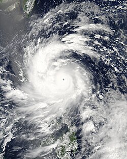
Early on August 8, the Joint Typhoon Warning Center (JTWC) reported that a tropical disturbance had developed north of Yap. [1] During that day, the system moved westwards and consolidated within a favourable environment of weak vertical wind shear and strong outflow, which was enhanced by a TUTT Cell located to the northwest of the disturbance. [2] [3] As a result, the Japan Meteorological Agency (JMA), JTWC and PAGASA upgraded the system to a tropical depression 11W north of Palau, with the latter naming it Labuyo as it approached the Philippine Area of Responsibility. [4] [5] [6] During the next day, JTWC and JMA upgraded the system to a tropical storm, with the latter naming it as Utor (1311). [4] [7] Shortly thereafter, Utor began undergoing explosive intensification, achieving typhoon status early on August 10, as an eye developed. [8]
On August 11, under the influence of low vertical wind shear, very favourable poleward and westward outflow, and warm sea surface temperature, Utor began to intensify more and formed a clear eye. [9] At 12:00 UTC, Typhoon Utor attained peak intensity by the ten-minute maximum sustained winds reaching 105 knots (195 km/h, 120 mph) and the atmospheric pressure decreasing to 925 hPa (27.3 inHg). The system became exceptionally symmetrical, as the convective bands had further deepened and wrapped tighter around a 13 nautical miles (24 km; 15 mi) pin-hole eye, prompting JTWC upgrading Utor to a super typhoon. [10] Due to land interaction with Luzon, the pin-hole eye filled in quickly; as a result, JTWC downgraded Utor to a typhoon at 18:00 UTC. [11] Tracking along the southern periphery of a subtropical ridge to the north, Utor made landfall over northern Luzon around 19:00 UTC (03:00 PHT on August 12). [12]
Owing to peaks of western Luzon, Utor significantly weakened as the deep convection became disorganised. Early on August 12, Utor arrived at the South China Sea, where the environment southwest of an anticyclone was favourable with diffluence aloft, light vertical wind shear and excellent radial outflow. [13] Although a ragged eye had formed later that day, the typhoon did not restrengthen further when tracking along the southern periphery of a subtropical ridge. [14] On August 13, the eye of Utor had become well-defined on the visible satellite imagery, but the intensity and structure remained when the system was tracking northwestward. [15] At 07:50 UTC (15:50 CST) on August 14, Utor made landfall over Yangxi County in Yangjiang, Guangdong, China as a minimal typhoon. [16] At 12:00 UTC, JMA downgraded Utor to a severe tropical storm, shortly before JTWC issued a final warning to the rapidly weakening system due to land interaction. [17] Later, Utor weakened into a tropical storm overland, and JMA downgraded the system into a tropical depression at noon on August 15. However, the remnants began tracking very slowly in Guangxi, until the tropical depression finally dissipated on August 18. [4]
Ahead of Utor affecting the Philippines, PAGASA issued various tropical cyclone signals for Luzon and Visayas, including signal 3 for the provinces of Aurora and Isabela and signal 1 for Metro Manila. [18] As Utor approached Central Luzon, a Malacanang Palace spokesperson called that local government to prepare and evacuate residents living near slopes, mountains and sea. [19] Thirty-two provinces in Luzon and Manila had been placed under signal warnings. [20] In Isabela, 67 families were evacuated before landfall. Under the anticipation of a direct hit, the local Pangasinan government placed the entire province on red alert. On August 11, the governor announced the suspension of classes from pre-school to tertiary level. Government and private offices were also suspended. Rescue equipment and rubber boats had also been placed in the disaster risk area of the province. [21] In the said regions, the government advised all to not engage in water sports or rough seas due to the anticipated rough seas. [22]
Utor made its landfall in Casiguran, Aurora at 3 AM (local time) on August 12. Power lines and telecommunications went down and many houses were destroyed. [23] In Nueva Vizcaya, heavy rainfall had been recorded. Some residents in the said province were forced to evacuate due to flooding. Moreover, the Magat River in the province reached the critical level, resulting in the partial opening of four gates in a dam. Electricity was also out in the province. One man died in Baguio after he had been buried alive after a mudslide hit his home. In Isabela, more than 100 families had been affected by Utor. About 200 million pesos in agriculture was blamed on Utor in Isabela alone. Around 1,000 residents in the central Bicol region spent the night in shelters, and 23 fishermen who were out at sea failed to return home in four towns in Catanduanes province. [24] Some cars in North Luzon Expressway used hazard signals as roads were nearly impossible to see. Intense rainfall throughout the day had been recorded in Zambales, which created flash flooding in low-lying areas. The major river in the province then overflowed, flooding homes. The flooding was expected to rise as high tide was expected in the morning. [25] At least 700 passengers were stranded in the ports of Albay, Catanduanes, Sorsogon and Samar. Additionally, 10 flights had also been canceled as Utor brought intense rainfall in many parts of Luzon. [26]
Throughout the Philippines, 11 people were killed while four others were listed as missing. A total of 407,493 people were affected by the typhoon, roughly a third of whom were displaced from their homes. Significant infrastructural damage took place with 2,592 homes destroyed and 21,197 more damaged. Losses from Utor amounted to ₱1.58 billion (US$36.4 million), the majority resulting from agricultural damage. [27]
The Chinese bulk carrier Trans Summer sank some 45 nautical miles (83 km; 52 mi) southwest of Hong Kong after having been caught in the typhoon. Twenty-one members of the crew were saved. [28]
Widespread damage took place in Guangdong Province where at least four people were killed and four others were listed missing. An estimated 1.09 million people were affected, 161,500 of whom were temporarily relocated due to the threat of flooding. Typhoon-force winds caused a belt factory in Dongguan to collapse, killing 1 person and injuring 17 others. [29] Losses across the province amounted to ¥8.63 billion (US$1.41 billion). [30] 18 people were killed in Guangxi Province while more than 1.3 million people were affected. Losses in the province reached ¥698 million (US$114 million). [31] Prolonged heavy rains in Hunan Province triggered widespread flooding that caused substantial damage. At least five people were killed and five others were listed missing while 964,600 people were affected by the storm. [32]
Following the storm, prices of vegetables were raised by an average of one percent in Guangzhou, while the price of leafy vegetables was raised by as much as 15 percent. [29] A total of 86 people were killed in Mainland China, while total damages were amounted to be ¥21.5 billion (US$3.51 billion). [33]
During their 2014 annual session, the ESCAP/WMO Typhoon Committee announced that the name Utor would be retired from the naming lists. The name Barijat was chosen to replace Utor, and was used for the first time in the 2018 season.
PAGASA announced that the name Labuyo, would be retired from its naming lists after it had caused over PHP1 billion in damages. [34] [35] PAGASA chose the name Lannie to replace Labuyo for the 2017 season.
The 2012 Pacific typhoon season was a slightly above average season that produced 25 named storms, fourteen typhoons, and four intense typhoons. It was a destructive and the second consecutive year to be the deadliest season, primarily due to Typhoon Bopha which killed 1,901 people in the Philippines. It was an event in the annual cycle of tropical cyclone formation, in which tropical cyclones form in the western Pacific Ocean. The season ran throughout 2012, though most tropical cyclones typically develop between May and October. The season's first named storm, Pakhar, developed on March 28, while the season's last named storm, Wukong, dissipated on December 29. The season's first typhoon, Guchol, reached typhoon status on June 15, and became the first super typhoon of the year on June 17.
The 2013 Pacific typhoon season was the most active Pacific typhoon season since 2004, and the deadliest since 1975. It featured Typhoon Haiyan, one of the most powerful storms and one of the strongest landfalling tropical cyclones in history. It was an above-average season with 31 named storms, 13 typhoons, and five super typhoons. The season's first named storm, Sonamu, developed on January 4 while the season's last named storm, Podul, dissipated on November 15. Despite the activity, most of the first seventeen named storms before mid-September were relatively weak, as only two of them reached typhoon intensity. Total damage amounted to at least $26.41 billion (USD), making it at the time the costliest Pacific typhoon season on record; it is currently the fourth costliest, behind the 2018, 2019 and 2023 seasons.
The 2015 Pacific typhoon season was a slightly above average season that produced twenty-seven tropical storms, eighteen typhoons, and nine super typhoons. The season ran throughout 2015, though most tropical cyclones typically develop between May and November. The season's first named storm, Mekkhala, developed on January 15, while the season's last named storm, Melor, dissipated on December 17. The season saw at least one named tropical system forming in each of every month, the first time since 1965. Similar to the previous season, this season saw a high number of super typhoons. Accumulated cyclone energy (ACE) during 2015 was extremely high, the third highest since 1970, and the 2015 ACE has been attributed in part to anthropogenic warming, and also the 2014-16 El Niño event, that led to similarly high ACE values in the East Pacific.
The 2018 Pacific typhoon season was at the time, the costliest Pacific typhoon season on record, until the record was beaten by the following year. The season was well above-average, producing twenty-nine storms, thirteen typhoons, seven super typhoons and six Category 5 tropical cyclones. The season ran throughout 2018, though most tropical cyclones typically develop between May and October. The season's first named storm, Bolaven, developed on January 3, while the season's last named storm, Man-yi, dissipated on November 28. The season's first typhoon, Jelawat, reached typhoon status on March 29, and became the first super typhoon of the year on the next day.
Typhoon Damrey was a compact tropical cyclone, which became the strongest to affect the area north of the Yangtze River since 1949. It was the tenth named storm and the fifth typhoon of the 2012 Pacific typhoon season. The name Damrey means elephant in Khmer, the official language of Cambodia.
Severe Tropical Storm Rumbia, known in the Philippines as Tropical Storm Gorio, was a tropical cyclone that brought widespread flooding in areas of the Philippines and China late June and early July 2013. The sixth internationally named storm of the season, Rumbia formed from a broad area of low pressure situated in the southern Philippine Sea on June 27. Steadily organizing, the initial tropical depression moved towards the northwest as the result of a nearby subtropical ridge. On June 28, the disturbance strengthened to tropical storm strength, and subsequently made its first landfall on Eastern Samar in the Philippines early the following day. Rumbia spent roughly a day moving across the archipelago before emerging into the South China Sea. Over open waters, Rumbia resumed strengthening, and reached its peak intensity with winds of 95 km/h (50 mph) on July 1, ranking it as a severe tropical storm. The tropical cyclone weakened slightly before moving ashore the Leizhou Peninsula late that day. Due to land interaction, Rumbia quickly weakened into a low pressure area on July 2 and eventually dissipated soon afterwards.
Severe Tropical Storm Trami, known in the Philippines as Severe Tropical Storm Maring, was a tropical cyclone that brought heavy rains to Taiwan and East China during mid-August 2013. Trami also made a fujiwhara interaction with Tropical Depression 13W north of it. The storm also enhanced the southwest monsoon causing more than 20 casualties in the Philippines.
Typhoon Usagi, known in the Philippines as Super Typhoon Odette, was a violent tropical cyclone which affected Taiwan, the Philippines, China, and Hong Kong in September 2013. Usagi, or which means the constellation Lepus in Japanese, was the fourth typhoon and the nineteenth tropical storm in the basin. Developing into a tropical storm east of the Philippines late on September 16, Usagi began explosive intensification on September 19 and ultimately became a violent and large typhoon. Afterwards, the system weakened slowly, crossed the Bashi Channel on September 21, and made landfall over Guangdong, China on September 22.
Most of the tropical cyclones of the 2013 Pacific typhoon season formed between May and November of that year. The scope of this article is the Pacific Ocean north of the equator, between 100°E and the International Date Line. Tropical storms which form in the Western Pacific basin are assigned a name by the Japan Meteorological Agency (JMA). Tropical depressions forming in this basin are given a number with a "W" suffix by the United States' Joint Typhoon Warning Center (JTWC). The Philippine Atmospheric, Geophysical and Astronomical Services Administration (PAGASA) assigns names to tropical cyclones that enter or form in the Philippine area of responsibility, but these names are not in common use outside the Philippines.
Typhoon Nari, known in the Philippines as Typhoon Santi, was a strong and deadly tropical cyclone that first struck Luzon before striking Vietnam. The storm was the 41st depression and the 8th typhoon in the 2013 typhoon season. Typhoon Nari was a deadly typhoon that made landfall in the Philippines and Vietnam. Nari made landfall on October 14, 2013 as a moderate category 1 typhoon.
Typhoon Krosa, known in the Philippines as Typhoon Vinta, was a typhoon that made landfall in the northern Philippines in late October 2013. Forming on October 27 near Guam, the storm slowly intensified while moving westward. Krosa developed an eye and became a typhoon before striking Luzon on October 31. The storm weakened over land, but re-intensified over the South China Sea, reaching peak winds of 150 km/h (93 mph) on November 2 off the southeast coast of China. Typhoon Krosa stalled and encountered unfavorable conditions, resulting in quick weakening. By November 3, it had weakened to tropical storm status, and was no longer being warned on by the next day. In northern Luzon, Krosa damaged 32,000 houses, including 3,000 that were destroyed, and caused four fatalities. High winds and rainfall left ₱277 million in damage.
Tropical Storm Hagibis was a tropical storm that, along with the southwest monsoon, brought heavy rainfall to the Philippines for nearly a week in June 2014. The storm formed on June 13 and dissipated on June 18. Hagibis made landfall on June 15, causing damage estimated to be US$198 million. Hagibis is a Filipino word, meaning fast or swiftness.
Severe Tropical Storm Linfa, known in the Philippines as Severe Tropical Storm Egay, was a tropical cyclone that affected the northern Philippines, Taiwan and southern China in early July 2015. The tenth named storm of the annual typhoon season, Linfa developed on July 1 over in the Philippine Sea. It moved erratically westward toward the Philippines, eventually striking the island of Luzon on July 4. Linfa weakened across the island, but reorganized over the South China Sea. It turned northward and strengthened to near typhoon intensity, or winds of 120 km/h (75 mph), but weakened as it curved to the northwest toward southern China. On July 9, the storm made landfall along the Chinese province of Guangdong, dissipating the next day west of Hong Kong.
Typhoon Nangka was a large and powerful tropical cyclone that impacted central Japan in mid-July 2015. Nangka started its long-living journey as a tropical disturbance over the Marshall Islands and west of the International Dateline, becoming the eleventh named storm of the annual typhoon season on July 3. It quickly intensified while moving to the west-northwest, attaining typhoon status on July 6. Nangka moved through the Northern Marianas Islands, passing directly over the uninhabited island of Alamagan. Shortly thereafter, the typhoon attained peak winds; the Japan Meteorological Agency (JMA) estimated 10‑minute sustained winds of 185 km/h (115 mph), while the unofficial Joint Typhoon Warning Center (JTWC) estimated 1‑minute winds of 250 km/h (155 mph), making it a super typhoon. Nangka later weakened as it curved to the north, moving across central Japan on July 16 as a minimal typhoon. The storm weakened soon after, dissipating in the Sea of Japan on July 18.
Typhoon Meranti, known in the Philippines as Super Typhoon Ferdie, was one of the most intense tropical cyclones on record. Impacting the Batanes in the Philippines, Taiwan, as well as Fujian Province in September 2016, Meranti formed as a tropical depression on September 8 near the island of Guam. Tracking to the west northwest, Meranti gradually intensified until September 11, at which point it began a period of rapid intensification. Continuing to rapidly intensify, it became a super typhoon early on September 12, as it passed through the Luzon Strait, ultimately reaching its peak intensity on September 13 with 1-minute sustained winds of 315 km/h (195 mph). Shortly afterwards, it passed directly over the island of Itbayat. Meranti passed to the south of Taiwan as a super typhoon, and began weakening steadily as a result of land interaction. By September 15, it struck Fujian Province as a Category 2-equivalent typhoon, becoming the strongest typhoon on record to impact the province. Upon moving inland, rapid weakening ensued and Meranti became extratropical the next day, dissipating shortly afterwards after it passed to the south of the Korean Peninsula.
Typhoon Nesat, known in the Philippines as Typhoon Gorio, was a strong tropical cyclone that impacted Taiwan and Fujian, China. It was the ninth named storm and the second typhoon of the annual typhoon season. After consolidating slowly for several days, Tropical Storm Nesat developed east of the Philippines on July 25. While experiencing favorable environmental conditions such as very warm sea surface temperatures and low wind shear, Nesat strengthened into a typhoon and reached its peak intensity on July 28. On July 29, the typhoon made landfall near the Taiwanese city of Yilan, before weakening to a severe tropical storm and making landfall again near Fuqing on China's east coast late the same day. Moving into July 30, Nesat continued to weaken under the effects of land interaction.
The 2021 Pacific typhoon season was the second consecutive to have below average tropical cyclone activity, with twenty-two named storms, and was the least active since 2011. Nine became typhoons, and five of those intensified into super typhoons. This low activity was caused by a strong La Niña that had persisted from the previous year. The season's first named storm, Dujuan, developed on February 16, while the last named storm, Rai, dissipated on December 21. The season's first typhoon, Surigae, reached typhoon status on April 16. It became the first super typhoon of the year on the next day, also becoming the strongest tropical cyclone in 2021. Surigae was also the most powerful tropical cyclone on record in the Northern Hemisphere for the month of April. Typhoons In-fa and Rai are responsible for more than half of the total damage this season, adding up to a combined total of $2.02 billion.
The 2022 Pacific typhoon season was the third consecutive season to have below average tropical cyclone activity, with twenty-five named storms forming. Of the tropical storms, ten became typhoons, and three would intensify into super typhoons. The season saw near-average activity by named storm count, although many of the storms were weak and short-lived, particularly towards the end of the season. This low activity was caused by an unusually strong La Niña that had persisted from 2020. The season's first named storm, Malakas, developed on April 6, while the last named storm, Pakhar, dissipated on December 12. The season's first typhoon, Malakas, reached typhoon status on April 12. The season ran throughout 2022, though most tropical cyclones typically develop between May and October. Tropical storms Megi and Nalgae were responsible for more than half of the casualties, while typhoons Hinnamnor and Nanmadol both caused $1 billion in damages.
Tropical Storm Barijat, known in the Philippines as Tropical Storm Neneng, was a weak tropical storm that caused flooding in the far northern regions of the Philippines and Southern China. Barijat, a replacement name for Utor which is a Marshallese word for coastal areas impacted by waves or winds, the thirty-third tropical depression and twenty-third tropical storm of the 2018 Pacific typhoon season, it was first noted as an area of convection in the South China Sea on September 6. On September 8, it was upgraded to a tropical depression, and by September 11, it intensified into a tropical storm, with the Japan Meteorological Agency (JMA) giving it the name Barijat. Barijat peaked in intensity 6 hours later, with 10-min winds of 40 knots and 1-min winds of 45 knots. Barijat continued westward, and on November 12 at 00:30 UTC, it made landfall over Zhanjiang, quickly dissipating afterwards.
Severe Tropical Storm Talim, known in the Philippines as Tropical Storm Dodong, was a compact tropical cyclone that affected the Philippines, China, and Vietnam. The fourth named storm of the 2023 Pacific typhoon season, Talim originated from a weak monsoon depression east of Manila while moving towards Luzon. The system continued to track westward close to the northern edge of mainland Luzon before emerging off the coast of Ilocos Norte. A favorable environment allowed the fledgling tropical storm to rapidly intensify to a Category 2-equivalent typhoon on the Saffir–Simpson scale. The storm maintained this intensity until shortly before landfall near Zhanjiang, Guangdong on July 17. Talim quickly weakened and dissipated early on July 18.
{{cite web}}
: CS1 maint: bot: original URL status unknown (link)