2006 Yogyakarta earthquake

Last updated
2006 Yogyakarta earthquake
JogjaEarthquake27Mei2006-2.jpg
Indonesia Java relief location map.png
Black pog.svg
Jakarta
Black pog.svg
Pangandaran
Black pog.svg
Yogyakarta
Bullseye1.png
UTC  time2006-05-26 22:53:58
ISC  event 8358516
USGS-ANSS ComCat
Local date27 May 2006 (2006-05-27)
Local time05:53 WIB (Indonesia Western Standard Time)
Magnitude6.4 Mw [1]
Depth15 km (9 mi) [1]
Epicenter 7°57′40″S110°26′46″E / 7.961°S 110.446°E / -7.961; 110.446
Bantul Regency [2]
Type Strike-slip
Areas affected Yogyakarta Special Region
Java, Indonesia
Total damageExtreme [3]
Max. intensity VIII (Damaging) [4]
IX (Violent) [5]
Peak acceleration0.336 g [6]
Casualties5,749–5,778 dead [7]
38,568–137,883 injured [7]
600,000–699,295 displaced [7]

The 2006 Yogyakarta earthquake (also known as the Bantul earthquake) occurred at 05:53 local time on 27 May with a moment magnitude of 6.4 and a maximum MSK intensity of VIII (Damaging). Several factors led to a disproportionate amount of damage and number of casualties for the size of the shock, with more than 5,700 dead, tens of thousands injured, and financial losses of Rp 29.1 trillion ($3.1 billion). With limited effects to public infrastructure and lifelines, housing and private businesses bore the majority of damage (the 9th-century Prambanan Hindu temple compound was also affected), and the United States' National Geophysical Data Center classified the total damage from the event as extreme.

Contents

Although Indonesia experiences very large thrust earthquakes offshore at the Sunda Trench, this was a large strike-slip event that occurred on the southern coast of Java near the city of Yogyakarta. Mount Merapi lies nearby, and during its many previous historical eruptions, large volume lahars and volcanic debris flowed down its slopes where settlements were later built. This unconsolidated material from the stratovolcano amplified the intensity of the shaking and created the conditions for soil liquefaction to occur. Inadequate construction techniques and poor quality materials contributed to major failures with unreinforced masonry buildings (then the most prevalent type of home construction), though other styles fared better.

Tectonic setting

The islands of Indonesia constitute an island arc that is one of the world's most seismically active regions, with high velocity plate movement at the Sunda Trench (up to 60 mm (2.4 in) per year), and considerable threats from earthquakes, volcanic eruptions, and tsunami throughout. Java, one of the five largest in the Indonesian archipelago, lies on the Sunda Shelf to the north of the Sunda Trench, which is a convergent plate boundary where the Indo-Australian Plate is being subducted under the Eurasian Plate. The subduction zone offshore Java is characterized by a northward dipping Benioff zone, frequent earthquakes and volcanic activity that influence the regional geography, and direct or indirect stress transfer that has affected the various onshore faults. Sedimentation is closely related to tectonics, and while the volume of offshore sediment at the trench decreases with distance from the Ganges-Brahmaputra Delta at the Bay of Bengal, the onshore accrual of sediments near the Special Region of Yogyakarta has been shaped by tectonic events. [8]

Earthquake

USGS ShakeMap for the mainshock USGS Shakemap - 2006 Yogyakarta earthquake.jpg
USGS ShakeMap for the mainshock

According to the United States Geological Survey (USGS), the shock occurred 20 km (12 mi) south-southeast of Yogyakarta at a depth of 10 km (6.2 mi), but other institutions provided source parameters (location and depth) that were not in agreement. No information was present on the extent of the faulting or the direction of propagation and there was no link to the eruption of Mount Merapi. The USGS suggested that the focal mechanism was most likely associated with left-lateral slip on a NE trending strike-slip fault, as that is the orientation of the Opak Fault, but this has not been validated. No surface breaks were documented, but the location of the greatest damage that was caused does align with the Opak Fault as a possible source. [9]

A group of Japanese and Indonesian scientists visited the area in March 2007 and confirmed the lack of surface ruptures, and pointed out that any visible expression of the fault would likely have been rapidly destroyed due to the tropical climate, and have acknowledged the widely varying locations (and the preference for the Opak Fault) that were reported by the various seismological institutions. Their investigation resulted in a different scenario, with an unknown or newly formed NE trending fault as the origin of the shock. Evidence for one of the proposed faults was found in the form of alignment of portions of the Oyo River near the USGS' epicenter, which is parallel (N°65E) to the Nglipar fault in the Gunungkidul region. If the shock occurred in this area it could indicate the reactivation of a major fault system. The second proposed fault further to the east is nearly parallel to the Ngalang and Kembang faults that lie to the north of the Oyo River. [10]

InSAR analysis

While the densely populated area that saw significant destruction is adjacent to the Opak River Fault, both the USGS and Harvard University placed the epicenter to the east of that fault. Few seismometers were operating in the region, but a group of temporary units that were set up following the mainshock recorded a number of aftershocks that were east of the Opak River Fault and were aligned along a 20 km (12 mi) zone striking N°50E. Due to the ambiguous nature of the available information on the source of the Yogyakarta earthquake, a separate group of Japanese and Indonesian scientists applied one of the first uses of interferometric synthetic aperture radar to determine the source fault. Several data sets (one captured in April 2006 and another post-earthquake batch from June) were collected from an instrument on board the Advanced Land Observation Satellite and were compared to each other to show potential ground deformation patterns. [11]

A lack of any dislocation found on the images along the Opak River fault made evident the lack of movement along that fault, and though the aftershocks were occurring at a depth of 8–15 km (5.0–9.3 mi), the deformation was distinct at the surface. The observed ground deformation that was detailed by the differential satellite images and Global Positioning System measurements was roughly 10 km (6.2 mi) east of (and parallel to) the Opak River Fault, along a zone that passed through the USGS' epicenter, and delineated a NE trending vertical fault (a dip of 89°). The displacements were not more than 10 cm (3.9 in) and indicated left-lateral strike-slip motion as well as a component of reverse slip, and to the west of the Opak River Fault (and closer to the areas of damage) strong ground motion triggered subsidence of volcanic deposits from Mount Merapi. [11]

Strong motion

In 2006, Mount Merapi had not been active for more than four years, but on May 11 a pyroclastic flow triggered the evacuation of more than 20,000 people from the northern sector of Yogyakarta. While authorities expected a larger eruption to follow, the earthquake occurred instead. The volcano's previous eruptions deposited loosely bound sedimentary material in the valley during lahar flows and this material was found to have played a significant role in the effects of the shock. For example, German and Indonesian scientists set up instruments at several locations situated on different soil types to measure aftershocks. Of nine events that were analyzed, it was found that the station at Imogiri (a heavily affected village that was built on 150–200 meters (490–660 ft) of sediment) showed signs of local amplification when compared to a location that was built on bedrock, and that the deposits amplified the impact of the shallow crustal rupture. [12]

The volcano with Prambanan Prambanan Java243.jpg
The volcano with Prambanan

Liquefaction

A separate post-event study looked at the relationship with the layer of sediment and the occurrence of soil liquefaction during earthquakes near Bantul. Researchers stated that the Yogyakarta region is seismically active, with four known events in the 19th century and three in the 20th century, with peak ground acceleration values of 0.038–0.531g. The type and properties of sediment control the occurrence and distribution of liquefaction, and other environmental conditions (like the water table) also play a part, as well as the peak ground acceleration of the earthquake. The Bantul-Klaten plain consists of alluvium (sand, silt, clay, and gravel) and volcanic deposits from Merapi (sand, agglomerates, tuff, and ash), as well as limestone and sandstone. Borehole and magnetic data surveys show that the alluvium and lahar deposits at the Bantul graben are 20–200 meters (66–656 ft) thick and at places over 200 meters, and the water table is 0.6–5 meters (2 ft 0 in – 16 ft 5 in) below ground level. Most liquefaction events took place near the 2.5 km (1.6 mi) wide Opak Fault zone. Sand boils, lateral spreading, settling, and slides led to some tilting and collapse of buildings. [13]

Damage

A fallen pinnacle from the damaged Prambanan temple Prambanan 2006 Damage.jpg
A fallen pinnacle from the damaged Prambanan temple

Altogether, eleven densely populated districts comprising 8.3 million people were affected, but the regencies of Bantul, Sleman, Gunung Kidul, Kulon Progo, Klaten, and the city of Yogyakarta were especially hard hit. More than 5,700 people were killed in the early morning shock, with tens of thousands injured, and hundreds of thousands made homeless. Total financial losses from the event are estimated to be Rp 29.1 Trillion ($3.1B), with 90% of the damage affecting the private sector (homes and private businesses) and only 10% affecting the public sector. The damage to housing accounted for about half of the total losses and a comparison was made to the damage to homes in Aceh following the 2004 Indian Ocean earthquake and tsunami. Damage in central Java was more pronounced because of the substandard construction practices and the high population density, but on the other end of the scale, damage to infrastructure was very limited. [14]

Housing

House damage in Bantul Regency JogjaEarthquake27Mei2006-8.jpg
House damage in Bantul Regency

With 154,000 houses destroyed and 260,000 units experiencing damage, the event was one of the most costly natural disasters in the previous ten years. With 7% of housing units lost, more houses were damaged than during the 2004 Sumatra–Andaman and the 2005 Nias–Simuele events combined. With 66,000 homes destroyed, the Klaten District saw the heaviest damage, followed by Bantul, with 47,000 destroyed. In the most heavily damaged areas, 70–90% of units destroyed, contributing to a total of 4.1 million cubic meters of debris. Of the three home construction styles used in the area, the most common type fared badly. Low quality materials and improper construction styles led to unreinforced masonry buildings being responsible for the large loss of life and the high number of injuries. The Earthquake Engineering Research Institute stated that there was a "lack of wall integrity in the transverse direction for out-of-plane forces" and "no mechanical connection between the top of the wall and the roof or floor, and inadequate out-of-plane strength due to a lack of reinforcement". [15]

Prambanan

The Prambanan Temple Compounds (also known as the Roro Jonggrang Temple) was constructed near the border of Yogyakarta and Central Java in 856, and was abandoned shortly thereafter. The site, which has experienced about 16 earthquakes since the 9th-century (including the 2006 event), consists of three yards of varying sizes with different stone block temples, and was rediscovered by a Dutch explorer in 1733. The smallest yard (110 m2) houses the main temple, and a slightly larger yard (220 m2) houses the Perwara temple. The main Prambanan Temple Complex is housed in the largest yard (390 m2). Many stones were dislodged and some parts broke off during the earthquake, and civil engineers were brought in to investigate the characteristics of the soil under the temple using ground penetrating radar, bore samples, and standard penetration tests. The goal was to visually examine the soil layers, to determine soil bearing capacity and depth of groundwater, as well as the depth of bedrock. Recommendations were then made regarding the renovations and repair process. [16]

International aid

Patients being treated at a hospital in Yogyakarta. Java Earthquake hospital.jpg
Patients being treated at a hospital in Yogyakarta.

Many countries and organizations offered foreign aid to the devastated region, but the actual amounts delivered/received often varied from these figures, as in the case of other disasters.

Reconstruction

Applying lessons learned from the Aceh recovery from the 2004 Indian Ocean earthquake and tsunami, the government of Indonesia promoted a community-driven approach in reconstruction from the 2006 Yogyakarta earthquake. The government leveraged social capital to hasten the reconstruction process. [32] In housing recovery for instance, both the government and NGOs introduced capacity building initiatives (e.g. socialization and on-the-spot training for the construction of earthquake-resistant housing such as penyuluhan and pelatihan teknis) and advocated for use of local materials (e.g., Merantasi). The Kecamatan Development Project (KDP) and the Urban Poverty Project (UPP) are examples NGOs supporting community-driven processes. [33]

The government was slow to implement assistance in reconstructing private houses, leading many homeowners to repair or rebuild their homes either by themselves or with community help. Reconstruction in some areas was aided by relief agencies, like the Red Cross Red Crescent.

Villagers rebuilt their homes with extremely limited resources, using simple affordable materials. They turned to traditional materials, such as bamboo, because of the damage inflicted by collapsing brick walls.

See also

Related Research Articles

<span class="mw-page-title-main">Special Region of Yogyakarta</span> Special autonomous region of Indonesia

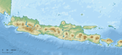
The Special Region of Yogyakarta is a province-level special region of Indonesia in southern Java. It is a semi-enclave that is surrounded by on the landward side by Central Java Province to the west, north, and east, but has a long coastline on the Indian Ocean to the south.

<span class="mw-page-title-main">Prambanan</span> 9th-century A Hindu temple compound in Special Region of Yogyakarta, Indonesia

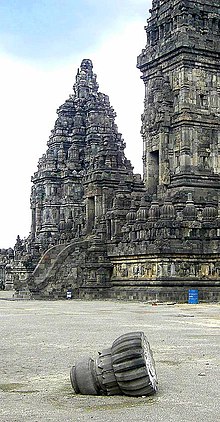
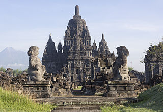
Prambanan is a 9th-century Hindu temple compound in the Special Region of Yogyakarta, in southern Java, Indonesia, dedicated to the Trimūrti, the expression of God as the Creator (Brahma), the Preserver (Vishnu) and the Destroyer (Shiva). The temple compound is located approximately 17 kilometres (11 mi) northeast of the city of Yogyakarta on the boundary between Central Java and Yogyakarta provinces.

<span class="mw-page-title-main">Mount Merapi</span> Active stratovolcano in Central Java, Indonesia

Mount Merapi is an active stratovolcano located on the border between the province of Central Java and the Special Region of Yogyakarta, Indonesia. It is the most active volcano in Indonesia and has erupted regularly since 1548. It is located approximately 28 km (17 mi) north of Yogyakarta city which has a population of 2.4 million, and thousands of people live on the flanks of the volcano, with villages as high as 1,700 m (5,577 ft) above sea level.

<span class="mw-page-title-main">Bantul Regency</span> Regency in Yogyakarta, Indonesia

Bantul is a regency located in the Special Region of Yogyakarta, Indonesia. It is located on the island of Java. The regency's population was 911,503 at the 2010 Census, but has risen to 985,770 at the 2020 Census and to 1,013,170 at the official estimates for mid 2022 - comprising 504,133 males and 509,037 females. Like many regencies on the island of Java, it is densely populated with roughly 1,999 people per square kilometre in 2022, although this is largely because the north of the regency partly surrounds the city of Yogyakarta and contains many suburban communities, notably in the densely-populated districts of Banguntapan, Sewon and Kasihan.

<span class="mw-page-title-main">Yogyakarta</span> Capital of the Special Region of Yogyakarta, Indonesia

Yogyakarta is the capital city of the Special Region of Yogyakarta in Indonesia, in the south-central part of the island of Java. As the only Indonesian royal city still ruled by a monarchy, Yogyakarta is regarded as an important centre for classical Javanese fine arts and culture such as ballet, batik textiles, drama, literature, music, poetry, silversmithing, visual arts, and wayang puppetry. Renowned as a centre of Indonesian education, Yogyakarta is home to a large student population and dozens of schools and universities, including Gadjah Mada University, the country's largest institute of higher education and one of its most prestigious.

<span class="mw-page-title-main">Klaten Regency</span> Regency in Indonesia

Klaten Regency is a regency in Central Java province in Indonesia. It covers an area of 701.52 km2 and had a population of 1,130,047 at the 2010 Census and 1,260,506 at the 2020 Census; the official estimate as at mid 2023 was 1,284,386. Its administrative centre is in the town of the same name; the town extends over 35.85 km2 to encompass three of the regency's districts, with a combined total of 135,681 inhabitants in mid 2023; a fourth district (Kalikotes) is part of its urban area.

<span class="mw-page-title-main">Sleman Regency</span> Regency in Yogyakarta, Indonesia

Sleman Regency is an Indonesian regency on the island of Java. It is located in the north of the Yogyakarta Special Administrative Region, Indonesia, and has an area of 574.82 square kilometres (221.94 sq mi), with a population of 1,093,110 at the 2010 Census and 1,125,804 at the 2020 Census; the official estimate as at mid 2022 was 1,147,562 - comprising 569,577 males and 577,985 females. Its capital is the town of Sleman. The current regent is Kustini Sri Purnomo.

<span class="mw-page-title-main">Bantul</span> Town and district in Yogyakarta Province, Indonesia

Bantul is a town and district, and the capital of Bantul Regency, Special Region of Yogyakarta, Indonesia. The district (kapanewon) covers an area of 21.95 km2 (8.47 sq mi) and had a population of 64,360 at the 2020 Census. It is a bustling town about 10 km (6.2 mi) to the south of Yogyakarta, easily reached by regular minibuses from the main Yogyakarta bus station. Bantul has numerous firms and agencies which supply services to the surrounding area. A main road runs down from Yogyakarta through Bantul to the busy beach area of Parangtritis visited by many tourists from Yogyakarta each weekend.

<span class="mw-page-title-main">Candi of Indonesia</span> Hindu and Buddhist temples and sanctuaries in Indonesia

A candi is a Hindu or Buddhist temple in Indonesia, mostly built during the Zaman Hindu-Buddha or "Hindu-Buddhist period" between circa the 4th and 15th centuries.

<span class="mw-page-title-main">Sewu</span> 8th-century Buddhist site in Indonesia

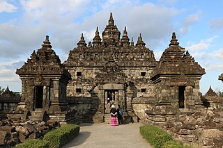
Sewu is an eighth-century Mahayana Buddhist temple located 800 metres north of Prambanan in Central Java, Indonesia. The word for a Hindu or Buddhist temple in Indonesian is "candi", hence the common name is "Candi Sewu". Candi Sewu is the second largest Buddhist temple complex in Indonesia; Borobudur is the largest. Sewu predates near the "Loro Jonggrang" temple at Prambanan. Although the complex consists of 249 temples, this Javanese name translates to 'a thousand temples,' which originated from popular local folklore. Archaeologists believe the original name for the temple compound to be Manjusrigrha.

<span class="mw-page-title-main">Opak River</span> River in Yogyakarta, Indonesia

Opak River is a river in central south area of Java island, Indonesia.

<span class="mw-page-title-main">Prambanan Temple Compounds</span> Group of temples in Indonesia

Prambanan Temple Compounds is the World Heritage designation of a group of Hindu temple compounds that lie on the border between Yogyakarta and Central Java, Indonesia. It comprises Prambanan, Lumbung, Bubrah and Sewu temple compounds, all are located within Prambanan Archaeological Park.

<span class="mw-page-title-main">2009 West Java earthquake</span> Earthquake in Indonesia

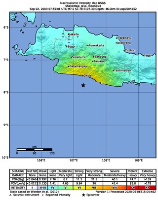
An earthquake occurred on September 2, 2009 at 14:55:01 local time in West Java, Indonesia. The magnitude 7.0 earthquake killed at least 81 people, injured over 1,297, and displaced over 210,000. The quake was felt in the capital Jakarta, although damage there was minimal, and it was Indonesia's deadliest earthquake since the 2006 Pangandaran earthquake and tsunami.

<span class="mw-page-title-main">Kewu Plain</span> Plain in Java, Indonesia

Kewu Plain, also known as Prambanan Plain or Opak River Valley, is a fertile volcanic plain that lies between the Merapi-Merbabu complex in the north, the Bantul lowlands and Sewu karst limestone range in the south, Bengawan Solo river valley in the east, the Progo River in the west, and Kedu Plain on the northwest. It is located within the Yogyakarta Special Region, Sleman Regency, Klaten Regency, and Solo City, Indonesia.

<span class="mw-page-title-main">2010 eruptions of Mount Merapi</span> Volcanic eruption of Mount Merapi in Indonesia

In late October 2010, Mount Merapi in border of Central Java and Special Region of Yogyakarta, Indonesia began an increasingly violent series of eruptions that continued into November. Seismic activity around the volcano increased from mid-September onwards, culminating in repeated outbursts of lava and volcanic ash. Large eruption columns formed, causing numerous pyroclastic flows down the heavily populated slopes of the volcano. The 2010 eruption of Merapi was the volcano's largest since 1872.

The 1943 Central Java earthquake occurred on July 23 at 14:53:10 UTC with a moment magnitude of 7.0 near Java, which was under Japanese occupation.

<span class="mw-page-title-main">Ganjuran Church</span> Catholic church in Indonesia

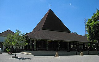
The Church of the Sacred Heart of Jesus, also known as the Ganjuran Church, is a Roman Catholic church located in Ganjuran, Bantul, Special Region of Yogyakarta, Indonesia. It is the oldest church in its administrative regency.

<span class="mw-page-title-main">2016 Aceh earthquake</span> Earthquake in Sumatra, Indonesia

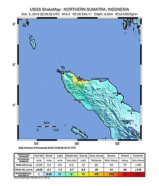
The 2016 Aceh earthquake struck the Indonesian island of Sumatra with a Mw of 6.5 in Aceh province on 7 December 2016, at 05:03 WIB. The shock was reported to be at a depth of 13 km, categorized as a strong, shallow earthquake. The epicentre was located near the village of Reuleut in Pidie Jaya Regency, 164 km (102 mi) southeast of the province's capital, Banda Aceh. 104 people died in the quake, with at least 1,000 people injured. It was the deadliest earthquake in Aceh since the 2005 Nias–Simeulue earthquake and the deadliest in Sumatra since the 2010 Mentawai earthquake and tsunami.

<span class="mw-page-title-main">2018 Sulawesi earthquake and tsunami</span> 7.5 Mw earthquake Landslide and tsunami in Indonesia

On 28 September 2018, a shallow, large earthquake struck in the neck of the Minahasa Peninsula, Indonesia, with its epicentre located in the mountainous Donggala Regency, Central Sulawesi. The magnitude 7.5 quake was located 70 km (43 mi) away from the provincial capital Palu and was felt as far away as Samarinda on East Kalimantan and also in Tawau, Malaysia. This event was preceded by a sequence of foreshocks, the largest of which was a magnitude 6.1 tremor that occurred earlier that day.

<span class="mw-page-title-main">1867 Java earthquake</span> Earthquake in the Dutch East Indies (present-day Indonesia)

The 1867 Central Java earthquake occurred on June 10 at between 04:20 and 04:30 local time. It struck off the southern coast of the Indonesian island with an estimated moment magnitude of 7.8 (Mw ). Widespread devastation occurred in Central Java, where as many as 700 people were killed. The intermediate-depth intraslab earthquake did not cause a tsunami.

References

  1. 1 2 ISC (2015), ISC-GEM Global Instrumental Earthquake Catalogue (1900–2009), Version 2.0, International Seismological Centre
  2. "Lokasi Prasasti Episentrum Gempa Bantul". kusnantokarasan.com. Retrieved 2024-01-12.
  3. National Geophysical Data Center / World Data Service (NGDC/WDS) (1972), Significant Earthquake Database (Data Set), National Geophysical Data Center, NOAA, doi:10.7289/V5TD9V7K
  4. Murakami, H.; Pramitasari, D.; Ohno, R. (2008). Human casualty and damage distribution in relation to seismic intensity in the 2006 Central Java earthquake in Indonesia (PDF). The 14th World Conference on Earthquake Engineering, October 12–17, 2008, Beijing, China.
  5. "M 6.4 – 10 km E of Pundong, Indonesia". 27 May 2006. Retrieved 2 August 2021.
  6. Elnashai et al. 2006, p. 18
  7. 1 2 3 USGS (September 4, 2009), PAGER-CAT Earthquake Catalog, Version 2008_06.1, United States Geological Survey
  8. Marso, J.; Anderson, R.; Frost, E. (2008), "A short note on the tectonic setting and regional geology of the area affected by the May 27, 2006, Yogyakarta earthquake and its usefulness in assessing seismic hazard", The Yogyakarta earthquake of May 27, 2006, Star Publishing Company, Inc., pp. 1.1–1.3, ISBN   978-0-89863-304-7
  9. Elnashai et al. 2006 , pp. 9, 15
  10. Setijadji, L. D.; Barianto, D. H.; Watanabe, K.; Fukuoka, K.; Ehara, S.; Rahardjo, W.; Sudarno, I.; Shimoyama, S.; Susilo, S.; Itaya, T. (2008), "Searching for the active fault of the Yogyakarta earthquake of 2006 using data integration on aftershocks, cenozoic geo-history, and tectonic geomorphology", The Yogyakarta earthquake of May 27, 2006, Star Publishing Company, Inc., pp. 4.1–4.4, 4.17, 4.18, ISBN   978-0-89863-304-7
  11. 1 2 Tsuji, T.; Yamamoto, K.; Matsuoka, T.; Yamada, Y.; Onishi, K.; Bahar, A.; Meilano, I.; Abidin, H. Z. (2009), "Earthquake fault of the 26 May Yogyakarta earthquake observed by SAR interferometry", Earth, Planets and Space, 61 (7): e29–e32, doi: 10.1186/BF03353189 , S2CID   1567864
  12. Walter, T. R.; Wang, R.; Luehr, B.-G.; Wassermann, J.; Behr, Y.; Parolai, S.; Anggraini, A.; Günther, E.; Sobiesiak, M.; Grosser, H.; Wetzel, H.-U.; Milkereit, C.; Sri Brotopuspito, P. J. K.; Harjadi, P.; Zschau, J. (2008), "The 26 May 2006 magnitude 6.4 Yogyakarta earthquake south of Mt. Merapi volcano: Did lahar deposits amplify ground shaking and thus lead to the disaster?", Geochemistry, Geophysics, Geosystems, 9 (5): 2, 5, 6, Bibcode:2008GGG.....9.5006W, doi: 10.1029/2007GC001810
  13. Sarah, D.; Soebowo, E. (2013), "Liquefaction Due to the 2006 Yogyakarta Earthquake: Field Occurrence and Geotechnical Analysis", Procedia Earth and Planetary Sciences, International Symposium on Earth Science and Technology, CINEST 2012, 6: 383–388, Bibcode:2013PrEPS...6..383S, doi: 10.1016/j.proeps.2013.01.050
  14. CGI 2006 , pp. 3, 7, 12, 13, 15
  15. EERI (2006), The Mw 6.3 Java, Indonesia, Earthquake of May 27, 2006 (PDF), EERI Special Earthquake Report, Earthquake Engineering Research Institute, pp. 1, 3, 4
  16. Suryolelono, K. B. (2008), "Investigation of the Prambanan temple after the May 27, 2006 Yogyakarta earthquake", The Yogyakarta earthquake of May 27, 2006, Star Publishing Company, Inc., pp. 16.1–16.9, ISBN   978-0-89863-304-7
  17. 1 2 3 4 "Aid pledges for Java victims rise". BBC News. 2006-05-29. Retrieved 2006-05-29.
  18. 1 2 "Aid offers pour in for Java quake". BBC News. 2006-05-28. Retrieved 2006-05-28.
  19. "U.S. Military Joins Indonesia Quake Relief". CBS News. 2006-05-31. Archived from the original on June 14, 2006. Retrieved 2006-05-31.
  20. "Australia send 80 skilled personnel to Yogyakarta". Antara. 2006-05-31. Archived from the original on 2006-06-13. Retrieved 2006-05-31.
  21. "China to offer 2 mln dollars aid to quake-hit Indonesia". People's Daily Online. 2006-05-28. Retrieved 2006-05-28.
  22. "Ottawa pledges $2M to Indonesia quake victims; no Canadians reported affected". Maclean's. 2006-05-27. Archived from the original on June 14, 2006. Retrieved 2006-05-28.
  23. "India steps up aid to Indonesia". The Hindu . 2006-05-29. Archived from the original on 2006-06-14. Retrieved 2006-05-30.
  24. "Mormons Donate for Indonesia Earthquake Relief". The Church of Jesus Christ of Latter-day Saints Newsroom. 2006-05-31. Archived from the original on 2006-06-14. Retrieved 2006-05-31.
  25. "All our students in Yogyakarta safe". The Star, Malaysia. 2006-05-28. Archived from the original on 2006-06-25. Retrieved 2006-05-28.
  26. "Singapore's aid teams arrive in quake-hit Java". Channel NewsAsia. 2006-05-28. Archived from the original on 2006-05-29. Retrieved 2006-05-28.
  27. "UN health agency rushes aid to quake-struck parts of Indonesia". UN News Centre. 2006-05-29. Retrieved 2006-05-30.
  28. "Vietnam sends rice aid to Java quake victims". VietNamNet Bridge. 2006-05-31. Archived from the original on 2006-06-13. Retrieved 2006-05-31.
  29. "Island aid for Indonesia". Manx Radio. 2006-05-31. Archived from the original on May 6, 2006. Retrieved 2006-06-01.
  30. "King orders dispatch of aid to Indonesian Earthquake Victims". Petra News Agency (Jordan). 2006-05-31. Archived from the original on June 14, 2006. Retrieved 2006-06-01.
  31. "Indonesia : EMERGENCY MEDICAL RELIEF TEAMS IN YOGYAKARTA, INDONESIA". Archived from the original on 2007-08-14. Retrieved 2007-07-20.
  32. International Recovery Platform (2006). Recovery Status Report: The Yogyakarta and Central Java Earthquake 2006 (PDF). IRP.
  33. Johnson, Laurie and Olshansky, R (2016). After Great Disasters: How Six Countries Managed Community Recovery (PDF). Lincoln Institute of Land Policy.{{cite book}}: CS1 maint: multiple names: authors list (link)

Sources