2012 Indian Ocean earthquakes

Last updated

2012 Indian Ocean earthquakes
Indian Ocean laea relief location map.jpg
Bullseye1.png
UTC  time2012-04-11 08:38:36
 2012-04-11 10:43:10
ISC  event 600860404
USGS-ANSS ComCat
  ComCat
Local date11 April 2012 (2012-04-11)
Local time15:38
 17:43
Magnitude8.6 Mw [1]
 8.2 Mw
Depth20.0 km (12.4 mi)
 25.1 km (15.6 mi)
Epicenter 2°18′40″N93°03′47″E / 2.311°N 93.063°E / 2.311; 93.063 [2]
Type Strike-slipIntraplate [3]
Areas affected Indonesia
Max. intensity MMI VII (Very strong)
TsunamiYes
Foreshocks7.2 Mw 10 Jan at 18:36 [1]
Aftershocks8.2 Mw 11 April at 10:43 [1]
Casualties10 dead [4]
12 injured [4]

The 2012 Indian Ocean earthquakes were magnitude 8.6 and 8.2 Mw undersea earthquakes that struck near the Indonesian province of Aceh on 11 April at 15:38 local time. Initially, authorities feared that the initial earthquake would cause a tsunami and warnings were issued across the Indian Ocean; however, these warnings were subsequently cancelled. [5] [6] These were unusually strong intraplate earthquakes and the largest strike-slip earthquake ever recorded. [3]

Contents

Tectonic setting

The 2012 earthquake's epicenter was located within the Indo-Australian Plate, which is divided into two sub- or proto-plates: the Indian, and Australian. At their boundary, the Indian and Australian Plates converge at 11 mm (0.4 in) per year in a NNW–SSE direction. This convergence is accommodated by a broad zone of diffuse deformation. As part of that intraplate deformation, north–south trending fracture zones have been reactivated from the Ninety East Ridge as far east as 97°E. [7]

The Indo–Australian Plate was formed after the amalgamation of the Indian Plate and the Australian Plate some 45 million years ago. [8] However, there is a relative movement between the Indian Plate and the Australian Plate. A process which would eventually split the Indo-Australian Plate in two probably started 8 to 10 million years ago and is still taking place. The 2012 Indian Ocean earthquake is associated to the reactivation of the NNE-striking sea floor fabric. [9] [10]

Earthquake

The magnitude 8.6 (Mw) earthquake occurred about 610 km (379 mi) southwest of Banda Aceh, Indonesia at 08:38 UTC on 11 April 2012. The earthquake occurred at a depth of 22.9 km (14.2 mi), which is considered relatively shallow according to the scale used by the United States Geological Survey (USGS). [2] The quake was originally reported as a magnitude 8.9, but was later downgraded to 8.6. It was felt as far away as Malaysia, the Maldives and in India. [11] The earthquake was caused by a strike-slip motion. The earthquake and the largest aftershock had a fault displacement of 21.3 m (70 ft). [12] The strike-slip nature of the earthquake meant that the movement displaced relatively little seawater and was less likely to cause a tsunami. [13]

USGS ShakeMap for the M8.6 event USGS map of the 2012 Indian Ocean Earthquake.jpg
USGS ShakeMap for the M8.6 event

Both the initial earthquake and the magnitude 8.2 aftershock were classified (based on their focal mechanisms) as strike-slip earthquakes, meaning that the crust on either side shifted against each other horizontally, rather than vertically. Since 2006 there have been three other earthquakes in the area with a similar faulting style. All these earthquakes were consistent with either left-lateral slip on SSW–NNE orientated strike-slip faults, or right-lateral slip on WNW–ESE orientated strike-slip faults, both compatible with the direction of convergence. [14] A back projection analysis of data collected by Hi-net, an observation network in Japan, found a complex pattern of four conjugate faults. There was a strong correlation between the fault rupture pattern and the distribution of the aftershocks. [15]

These earthquakes have a complex rupture process. The rupture of these earthquakes occurred on multiple, almost orthogonal faults. This is rare in a single earthquake. This earthquake had an overall relatively slow rupture speed, although the speed was above the S-wave velocity in some fault segments. [15] [16] The rupture may have affected the crust and the upper mantle according to the kinematic source inversion. [17] The rupture was caused by ductile shear heating instability which is different from frictional failure and operates between 600–800 °C (1,112–1,472 °F), which corresponds to about the depths of 40–60 km (25–37 mi). The serpentinization of oceanic lithosphere can lead to a low friction coefficient, but the reaction is possible only up to 400–500 °C (752–932 °F), which corresponds to the depth of about 25 km (16 mi). A single dynamic weakening mechanism which can work over the whole range of slip of this earthquake is still to be identified. [16] [18]

Damage

Four people in their 60s and 70s in Banda Aceh, and a 39-year-old man in Lhokseumawe died from heart attacks or shock. Injuries were reported in Aceh Singkil, including a child who was critically injured by a falling tree. [19] The quake prompted people in Indonesia, Thailand and India to leave their homes and offices in fear of tsunamis. [20] People headed for higher ground in parts of Indonesia and Malaysia. [11] [21] In Aceh, where 31,000 people were killed in the 2004 Indian Ocean earthquake and tsunami, people were reported weeping. [22] Some people used cars and motorcycles to reach higher ground. Patients were reportedly wheeled out of hospitals, some with drips attached to their arms. One hotel guest was slightly injured when he jumped out of his window to save himself. [23]

The earthquake was felt over a large area, including Indonesia, the Maldives, Sri Lanka, India, Nepal, Bhutan, China, Bangladesh, Myanmar, Thailand, Malaysia, Laos, Cambodia, Singapore, and Vietnam. [24] [25] [26] The quake was felt across the eastern coast of India including Chennai, Bangalore, Kochi, Bhubaneswar, Vizag and Kolkata. The Metro Rail services were suspended in Kolkata, and passengers were asked to leave stations. [27] In peninsular Malaysia, shaking was felt in Penang and Kuala Lumpur. [28] The tremor was felt in Colombo, Sri Lanka, where people in some high-rise buildings were evacuated. [29] In China, the earthquake was felt in Tibet. However, it was not reported to be felt in places closer to the epicenter such as Yunnan and Guangxi. [30]

Aftershocks

A magnitude 8.2 aftershock struck at a depth of 16.4 kilometres (10.2 mi) about 430 km (267 mi) southwest of Banda Aceh at 10:43 UTC, two hours after the initial earthquake. [31] It was oddly reported as an 8.8 Mw before being quickly downgraded. [32] Many aftershocks with magnitude readings between 5.0 and 6.0 were recorded for several hours after the initial earthquake which hit the west coast of northern Sumatra. [33] [34] Since the initial magnitude 8.6 earthquake, there have been 111 aftershocks over magnitude 4.0 according to USGS, including a magnitude 6.2 on 15 April 2012. [35] [36]

Tsunami warnings

People evacuating high rise buildings on the streets in Kolkata, India, in front of the Cognizant building. Earthquake Leads Office Evacuation - Sector-V - Salt Lake City - Kolkata 2012-04-11 9367.JPG
People evacuating high rise buildings on the streets in Kolkata, India, in front of the Cognizant building.

Three hours after the initial quake it was still unclear whether a tsunami had been generated or if a tsunami had done any significant damage. A geophysicist from the Pacific Tsunami Warning Center (PTWC) stated that a gauge closest to the epicenter recorded a wave peak of about 1 m (3 ft). [37] The Pacific Tsunami Warning Center said that at 10:14 UTC that a tsunami was generated and may have already caused some coastal destruction. [38] A seismologist from the British Geological Survey [39] said that the "tearing earthquake" displaced relatively little water and was therefore unlikely to cause a significant tsunami. [24] Indonesian authorities also issued a statement saying that the likelihood of a tsunami was low. [40]

Tsunami warnings were issued in the following countries: Indonesia, Australia, Cambodia, Malaysia, Singapore, Thailand, Myanmar, Bangladesh, India, Sri Lanka, Maldives, Pakistan, Iran, United Arab Emirates, Oman, Yemen, Somalia, Kenya, Tanzania, Seychelles, Mozambique, Mauritius, Comoros, Madagascar, South Africa and the dependencies of Diego Garcia as part of the British Indian Ocean Territories, Crozet Islands, Réunion and Kerguelen Islands. Projected tsunami arrival times in GMT were: 8:38 for Indonesia, 11:38 for Sri Lanka, 14:38 for the Seychelles, 17:38 for Madagascar and 20:38 for South Africa. [11]

India

After the earthquake, the Indian National Centre for Ocean Information Services (INCOIS) issued a high-level tsunami warning for the Andaman and Nicobar Islands. [41] Authorities told civilians to move away from the coast and towards higher ground. [42] Areas subject to warnings included Tamil Nadu, Andhra Pradesh and the Union Territory of Andaman and Nicobar Islands. [43] Prabkhakar Rao of the disaster control room in Port Blair said that there could be tsunamis as high as 1.5 m (4.9 ft) at Port Blair and 3.9 m (12.8 ft) at Campbell Bay. [11]

In Kolkata, underground Metro Railways services were stopped and tall office buildings and shopping malls were evacuated. Navy warships were put on high alert. The Indian Air Force dispatched two C-130s and one Il-76 aircraft to the Andaman islands. [44]

Evacuation order issued by Ministry of Disaster Management and Human Rights in Sri Lanka Sri lanka DMC evacuation order issued 11 April.jpg
Evacuation order issued by Ministry of Disaster Management and Human Rights in Sri Lanka

Sri Lanka

The Ministry of Disaster Management and Human Rights (Sri Lanka) authorised an evacuation order [45] at 9:08 UTC advising people living near coastal regions to move to higher ground. The initial quake was not expected to affect Sri Lanka, but aftershocks were being monitored. [46] Deputy Director M. D. Dayananda said that a tsunami could hit Trincomalee. [11]

As part of a risk mitigation measure, the Ceylon Electricity Board disconnected power supplies to coastal areas and railway control rooms. Coastal train services were suspended. [47] The Road Development Authority removed toll charges from the Southern Sri Lanka Distributor to aid the evacuation. [48] Coastal bus services were temporarily re-routed. [49]

Thailand

Six Andaman coast provinces urged people to go to high ground and stay away from areas that could be affected. Phuket International Airport was closed. [11] The alerts caused panic as people fled buildings and made for high ground.[ citation needed ]

During the initial earthquake and for more than two hours after, none of Thailand's free television stations reported the earthquake or tsunami warnings, preferring to continue a live broadcast of a royal family ceremony, despite the National Broadcasting and Telecommunications Commission (NBTC)'s urgent order directing the emergency information to be broadcast instead without delay. [50] This caused criticism on the internet, although it was muted by a lèse majesté law. [51] The Television Pool of Thailand defended their actions, saying that running texts about the warnings were displayed onscreen during the broadcast. [51]

Tsunami

Small 0.5 m (20 in) waves, within regular tide limits, were reported in the Campbell Bay area of Great Nicobar Island, [11] and 10 cm (4 in) waves were reported in Thailand. [52] [53] The Indonesian Agency for Meteorology, Climatology and Geophysics said three small tsunamis struck the Aceh coast. The highest was 80 cm (31 in), at Meulaboh. [54] After the sea was seen receding about 10 metres (33 ft) at Simeulue, a 1 m (3 ft) wave was observed. Simeulue is an island of fishing villages 150 km (93 mi) off the west coast of Sumatra. [55]

See also

Related Research Articles

<span class="mw-page-title-main">2004 Indian Ocean earthquake and tsunami</span> Earthquake and subsequent tsunami in the Indian Ocean

On 26 December 2004, at 07:58:53 local time (UTC+7), a major earthquake with a magnitude of 9.1–9.3 Mw struck with an epicentre off the west coast of northern Sumatra, Indonesia. The undersea megathrust earthquake, known by the scientific community as the Sumatra–Andaman earthquake, was caused by a rupture along the fault between the Burma Plate and the Indian Plate, and reached a Mercalli intensity up to IX in some areas.

<span class="mw-page-title-main">2005 Nias–Simeulue earthquake</span> 2005 earthquake in Sumatra, Indonesia

The 2005 Nias–Simeulue earthquake occurred on 28 March off the west coast of northern Sumatra, Indonesia. At least 915 people were killed, mostly on the island of Nias. The event caused panic in the region, which had already been devastated by the massive tsunami triggered by the 2004 Indian Ocean earthquake, but this earthquake generated a relatively small tsunami that caused limited damage. It was the third most powerful earthquake since 1965 in Indonesia.

<span class="mw-page-title-main">Kamchatka earthquakes</span> Earthquakes in the Kamchatka Peninsula, far eastern Russia

Many major earthquakes have occurred in the region of the Kamchatka Peninsula in far eastern Russia. Events in 1737, 1923 and 1952, were megathrust earthquakes and caused tsunamis. There are many more earthquakes and tsunamis originating from the region.

<span class="mw-page-title-main">Great Sumatran fault</span> Geological feature

The Indonesian island of Sumatra is located in a highly seismic area of the world. In addition to the subduction zone off the west coast of the island, Sumatra also has a large strike-slip fault, the Great Sumatran Fault also known as Semangko Fault, running the entire length of the island. This fault zone accommodates most of the strike-slip motion associated with the oblique convergence between the Indo-Australian and Eurasian plates. The fault ends in the north just below the city of Banda Aceh, which was devastated in the 2004 Indian Ocean earthquake. After the December 2004 earthquake, pressure on the Great Sumatran Fault has increased tremendously, especially in the north.

<span class="mw-page-title-main">September 2007 Sumatra earthquakes</span> Earthquakes affecting Indonesia

The September 2007 Sumatra earthquakes were a series of megathrust earthquakes that struck the Sunda Trench off the coast of Sumatra, Indonesia, with three of magnitude 7 or greater. A series of tsunami bulletins was issued for the area. The most powerful of the series had a magnitude of 8.4, which makes it in the top 20 of the largest earthquakes ever recorded on a seismograph.

<span class="mw-page-title-main">2000 Enggano earthquake</span> Earthquake affecting Indonesia

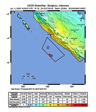
At 23:28 local time on June 4, 2000 southern Sumatra, Indonesia was struck by an earthquake of moment magnitude 7.9 with a maximum Mercalli intensity of VI (Strong). The event occurred off the coast near Enggano Island. There were more than 100 fatalities and up to 2,585 injuries. Over 730 aftershocks shook the area afterwards, one just eleven minutes after the mainshock.

<span class="mw-page-title-main">2010 Mentawai earthquake and tsunami</span> 2010 Indonesian earthquake and tsunami

The 2010 Mentawai earthquake occurred with a moment magnitude of 7.8 on 25 October off the western coast of Sumatra at 21:42 local time. The earthquake occurred on the same fault that produced the 2004 Indian Ocean earthquake. It was widely felt across the provinces of Bengkulu and West Sumatra and resulted in a substantial localized tsunami that struck the Mentawai Islands.

A potent magnitude 6.6 Mw intraplate aftershock occurred at 17:16 JST (08:16 UTC) on 11 April, in the Hamadōri region of Fukushima, Japan. With a shallow focus of 13 km (8.1 mi), the earthquake was centred inland about 36 km (22 mi) west of Iwaki, causing widespread strong to locally severe shaking. It was one of many aftershocks to follow the 11 March Tōhoku earthquake, and the strongest to have its epicentre located inland.

On 2 July 2013, an earthquake struck the Indonesian island of Sumatra on 2 July with a moment magnitude of 6.1 and a maximum Mercalli intensity of VI (Strong). The strike-slip earthquake killed at least 43 people and injured more than 2,500 others in the province of Aceh where approximately 4,300 homes were damaged or destroyed.

<span class="mw-page-title-main">2016 Sumatra earthquake</span> Earthquake off the coast of Sumatra, Indonesia

The 2016 Sumatra earthquake was a 7.8 magnitude earthquake which struck on 2 March 2016 in the Indian Ocean, approximately 800 kilometers southwest of Sumatra in Indonesia. Tsunami warnings were issued for Indonesia and Australia, but were withdrawn two hours later. There were no deaths directly related to the earthquake.

The 1907 Sumatra earthquake occurred on January 4 at 05:19:12 UTC. The estimated magnitude is 7.5–8.0 Ms, with an epicentre close to Simeulue, off Sumatra. It triggered a widespread and damaging tsunami that caused at least 2,188 deaths. The low observed intensity compared to the size of the tsunami has led to its interpretation as a tsunami earthquake. Higher levels of shaking observed on Nias are attributed to a large aftershock, less than an hour later. The tsunami gave rise to the S'mong legend, which is credited with saving many lives during the 2004 earthquake.

<span class="mw-page-title-main">2016 Solomon Islands earthquakes</span> Seismic events

On 9 December 2016 at 4:38 a.m. local time, the Solomon Islands region was rocked by an Mww 7.8 earthquake, centered 30 km off San Cristobal Island, about 61 km southwest of Kirakira, the capital of Makira-Ulawa Province. Initially registering magnitude 8.0, later downgraded to 7.8, the temblor prompted tsunami warnings that kept countries surrounding the Coral, Tasman and Solomon Sea on high alert, but was later cancelled. A large aftershock of magnitude 6.9 occurred shortly afterwards. This earthquake was largely felt, waking many residents who later ran to high ground for fears of a potential tsunami. The earthquake killed a child and affected some 34,000 people in Makira, South Malaita and Guadalcanal Island where many had lost their homes or had no access to basic needs. Earthquakes are common in this region, with little or no fatalities. This earthquake is tied with three other magnitude 7.8 earthquakes for the second largest earthquake of 2016. On 17 December, the Solomon Islands would be rattled again by a 7.9 magnitude earthquake, this time 54 km east of Taron, Papua New Guinea.

The 2018 Fiji earthquakes occurred on August 19, at 00:19:40 UTC and on September 6 15:49 UTC. The epicenters were located close to the Fijian island Lakeba, and around 270 km from the small town of Levuka on Ovalau. The first earthquake registered a magnitude of Mww  8.2, and is the largest earthquake of 2018. It had a focal depth of 600 km, making it the second largest earthquake ever recorded at a depth greater than 300 km; a tie with the 1994 Bolivia earthquake, and behind the 2013 Okhotsk Sea earthquake. The initial earthquake was caused by a normal fault below the South Pacific Ocean. An Mww  7.9 event struck the islands again on September 6 at a depth of 670 km; this earthquake was a mainshock of its own. Both earthquakes may be considered a doublet event.

<span class="mw-page-title-main">2013 Craig, Alaska earthquake</span> Earthquake in Alaska and British Columbia

The 2013 Craig, Alaska earthquake struck on January 5, at 12:58 am (UTC–7) near the city of Craig and Hydaburg, on Prince of Wales Island. The Mw 7.5 earthquake came nearly three months after an Mw  7.8 quake struck Haida Gwaii on October 28, in 2012. The quake prompted a regional tsunami warning to British Columbia and Alaska, but it was later cancelled. Due to the remote location of the quake, there were no reports of casualties or damage.

<span class="mw-page-title-main">2008 Simeulue earthquake</span> Earthquake in Indonesia

On February 20, 2008, an earthquake with a moment magnitude of 7.4 struck off the coast of Sumatra at a hypocentre depth of 26 km. The earthquake had an epicenter located on the island of Simeulue, northwest from Sinabang, a small town on the island. Three people were killed and an additional 25 seriously injured as a result of the earthquake.

<span class="mw-page-title-main">2021 Chignik earthquake</span> 7th largest earthquake in the US

An earthquake occurred off the coast of the Alaska Peninsula on July 28, 2021, at 10:15 p.m. local time. The large megathrust earthquake had a moment magnitude of 8.2 according to the United States Geological Survey (USGS). A tsunami warning was issued by the National Oceanic and Atmospheric Administration (NOAA) but later cancelled. The mainshock was followed by a number of aftershocks, including three that were of magnitude 5.9, 6.1 and 6.9 respectively.

The 2021 South Sandwich Islands earthquakes were a pair of powerful earthquakes, followed by many strong aftershocks which struck along the South Sandwich Trench in August 2021. The quakes measured 7.5 and 8.1 on the moment magnitude scale, according to the United States Geological Survey. The mainshock is tied with another event in 1929 as the largest earthquake ever recorded in the South Atlantic region, and is tied with the 2021 Kermadec Islands earthquake as the second largest earthquake of 2021.

<span class="mw-page-title-main">2021 Flores earthquake</span> Earthquake in Indonesia

An earthquake occurred 112 km, offshore, north of Maumere in the Flores Sea on 14 December. The quake had a moment magnitude of 7.3 according to the United States Geological Survey (USGS). One person was killed and 173 others suffered injuries.

The 1843 Nias earthquake off the northern coast of Sumatra, Indonesia caused severe damage when it triggered a tsunami along the coastline. The earthquake with a moment magnitude (Mw ) of 7.8 lasted nine minutes, collapsing many homes in Sumatra and Nias. It was assigned a maximum modified Mercalli intensity of XI (Extreme).

The 1933 Sumatra earthquake or Liwa earthquake occurred in West Lampung Regency, Lampung Province, Indonesia on June 25. The earthquake had an estimated surface-wave magnitude (Ms ) of 7.7 occurring at a shallow depth of 20 km. It had an epicenter onshore, devastating the city of Liwa. At least 76 people were reported killed, although the death toll may have been in the thousands. Aftershocks followed, including one which was strong enough to cause additional fatalities. The mainshock also triggered a nearby volcanic eruption two weeks later, killing some people.

References

  1. 1 2 3 Wei, S.; Helberger, D.; Avounac, J-P. (2013), "Modeling the 2012 Wharton Basin earthquakes off-Sumatra: Complete Lithospheric failure" (PDF), Journal of Geophysical Research , 118 (7): 3595, Bibcode:2013JGRB..118.3592W, doi: 10.1002/jgrb.50267
  2. 1 2 "Magnitude 8.6 – OFF THE WEST COAST OF NORTHERN SUMATRA". United States Geological Survey. 11 April 2012. Archived from the original on 6 September 2017. Retrieved 11 April 2012.
  3. 1 2 Prasad, R. (12 April 2012). "Why April 11 quake was caused by a strike-slip fault". The Hindu. Chennai, India. Retrieved 13 April 2012.
  4. 1 2 USGS. "M8.6 – off the west coast of northern Sumatra". United States Geological Survey.
  5. NewsCore (11 April 2012). "Indian Ocean tsunami alert cancelled after two strong quakes hit off Sumatra, Indonesia". Herald Sun . Retrieved 11 April 2012.
  6. "Huge quake strikes off Indonesia, tsunami warning issued". Reuters. 11 April 2012. Retrieved 11 April 2012.
  7. Kreemer, C.; Holt W.E. & Haines A.J.; Haines, A. John (2003). "An integrated global model of present-day plate motions and plate boundary deformation". Geophysical Journal International. 154 (1): 8–34. Bibcode:2003GeoJI.154....8K. doi: 10.1046/j.1365-246X.2003.01917.x .
  8. Sanford, M.; Coblentz, D.D.; Richardson, R.M. (1995), "Ridge torques and continental collision in the Indian-Australian plate" (PDF), Geology, 23 (7): 653–656, Bibcode:1995Geo....23..653S, doi:10.1130/0091-7613(1995)023<0653:RTACCI>2.3.CO;2, archived from the original (PDF) on 20 April 2013, retrieved 24 February 2013
  9. "April Sumatra quakes signal Indian ocean plate break-up". BBC News. 26 September 2012.
  10. "The 2012 Mw 8.6 Sumatra earthquake: Evidence of westward sequential seismic ruptures associated to the reactivation of a N–S ocean fabric" by C. Satriano, E. Kiraly, P. Bernard, and J.-P. Vilotte
  11. 1 2 3 4 5 6 7 "Indian Ocean on tsunami alert after quakes". Al Jazeera. 11 April 2012. Retrieved 11 April 2012.
  12. "Scientists: Magnitude-8.6 Indonesia jolt was unusually large for a strike-slip quake; Winnipeg Free Press". The Canadian Press. 11 April 2012. Retrieved 11 April 2012.
  13. "Explained: What is a slip-strike quake, and why there was no tsunami – World – DNA". Daily News and Analysis. 11 April 2012.
  14. United States Geological Survey (11 April 2012). "Poster of the M8.6 Northern Sumatra, Earthquake of 11 April 2012" (PDF). Retrieved 12 April 2012.
  15. 1 2 Wang, D.; Mori, J.; Uchide, T. (2012). "Supershear rupture on multiple faults for the Mw 8.6 Off Northern Sumatra, Indonesia earthquake of April 11, 2012". Geophysical Research Letters . 39 (21): n/a. Bibcode:2012GeoRL..3921307W. doi: 10.1029/2012GL053622 .
  16. 1 2 Meng L., L.; Ampuero, J.-P.; Stock, J.; Duputel, Z.; Luo, Y.; Tsai, V.C. (2012). "Earthquake in a Maze: Compressional Rupture Branching During the 2012 Mw 8.6 Sumatra Earthquake" (PDF). Science . 337 (6095): 724–726. Bibcode:2012Sci...337..724M. doi:10.1126/science.1224030. PMID   22821986. S2CID   130085680. Archived from the original (PDF) on 4 March 2016. Retrieved 1 January 2015.
  17. "Séismes au large de Sumatra mercredi 11 avril 2012" (in French). Institut de Physique du Globe de Paris. Archived from the original on 24 June 2013. Retrieved 9 February 2013.
  18. McGuire, J.; Beroza, G.C. (2012). "A Rogue Earthquake Off Sumatra" (PDF). Science . 336 (6085): 1118–1119. Bibcode:2012Sci...336.1118M. doi:10.1126/science.1223983. PMID   22582017. S2CID   206542279. Archived from the original (PDF) on 29 October 2013. Retrieved 13 August 2012.
  19. Jakarta BNPB
  20. "Massive earthquake strikes Indonesia, tremors felt in India". The Times of India . Reuters. 11 April 2012. Retrieved 11 April 2012.
  21. "Massive earthquake off Indonesia". TVNZ. 11 April 2012. Retrieved 11 April 2012.
  22. NDTV News. "Strong Indonesian quakes cause panic, not tsunami". Associated Press. Retrieved 12 April 2012. Women and children cried in Aceh, where memories of a 2004 tsunami that killed 170,000 people in that province alone are still raw. Others screamed "God is great" as they poured from their homes or searched frantically for separated family members
  23. NDTV News. "Strong Indonesian quakes cause panic, not tsunami". Associated Press. Retrieved 12 April 2012.
  24. 1 2 "Indian Ocean tsunami alert lifted after Aceh quake". BBC News. 11 April 2012. Retrieved 11 April 2012.
  25. "Strong earthquake in Sumatra slightly felt in Yangon – Xinhua | English.news.cn". Xinhua News Agency. Archived from the original on 23 August 2014. Retrieved 12 April 2012.
  26. The Brief » Blog Archive » Tremors felt. Nepali Times. Retrieved 13 April 2012.
  27. "News : Tremors across eastern coast; people evacuated from Andamans". The Hindu . Chennai, India. Press Trust of India. 11 April 2012. Retrieved 11 April 2012.
  28. "8.6 earthquake hits Aceh, tsunami alert issued (Update) | theSundaily". The Sun. Malaysia. 11 April 2012. Retrieved 11 April 2012.[ permanent dead link ]
  29. "Large Aceh quake triggers Indian Ocean tsunami warning – Tremor felt in Colombo | Independent Television Network News". Itnnews.lk. 11 April 2012. Retrieved 11 April 2012.
  30. 专家表示:印尼地震造成我国西藏地区有震感属正常 – 新华社会 – 新华网. News.xinhuanet.com. Retrieved 13 April 2012.
  31. "8.2-magnitude aftershock hits off Sumatra". US Geological Survey (USGS). 11 April 2012. Archived from the original on 13 April 2012. Retrieved 11 April 2012.
  32. "New tsunami warning after magnitude 8.8 aftershock in Indonesia". ITV News. 11 April 2012. Retrieved 26 July 2021.
  33. "M8.2 – off the west coast of northern Sumatra". United States Geological Survey. 11 April 2012. Retrieved 11 April 2012.
  34. "Latest Earthquakes M5.0+ in the World – Past 7 days". Earthquake.usgs.gov. 11 April 2012. Archived from the original on 24 November 2010. Retrieved 11 April 2012.
  35. "10-degree Map Centered at 0°N,90°E". U.S. Geological Survey. 16 April 2012. Archived from the original on 8 April 2013. Retrieved 16 April 2012.
  36. "Magnitude 6.2 – off the West Coast of Northern Sumatra". U.S. Geological Survey. 15 April 2012. Archived from the original on 18 April 2012. Retrieved 16 April 2012.
  37. "Indonesia earthquake: No damage to ocean basin, India withdraws tsunami warning". The Indian Express . 11 April 2012. Retrieved 11 April 2012.
  38. "Pacific Tsunami Warning Center/NOAA/NWS: Tsunami bulletin number 003". PTWC. 11 April 2012. Archived from the original on 13 April 2012. Retrieved 11 April 2012.
  39. "Staff Profile of Dr Roger Musson | British Geological Survey". BGS. Retrieved 12 April 2012.
  40. "Watch: Indonesia Reacts to 8.7 Magnitude Earthquake". TIMES. 11 April 2012. Retrieved 11 April 2012.
  41. "Indonesia earthquake: India issues tsunami warning for Andaman and Nicobars". The Times of India. Agence France-Presse. 11 April 2012. Retrieved 11 April 2012.
  42. "Earthquake in Indonesia: How India responded". NDTV. 11 April 2012. Retrieved 11 April 2012.
  43. "Earthquake in Indonesia: India withdraws tsunami warning". NDTV. 11 April 2012. Retrieved 11 April 2012.
  44. TOI, Times of India (12 April 2012). "8.6 magnitude quake in Aceh triggers tsunami fears in India". The Times of India . Archived from the original on 30 July 2013.
  45. "Tsunami warning in South and East | Top Story". Daily Mirror . 11 April 2012. Archived from the original on 14 April 2012. Retrieved 11 April 2012.
  46. "Tsunami Warning Evacuation Bulletin". 11 April 2012. Retrieved 11 April 2012.
  47. "Trains stopped, power to be disconnected | Breaking News". Daily Mirror . 11 April 2012. Archived from the original on 14 April 2012. Retrieved 11 April 2012.
  48. "Expressway free of charge | Breaking News". Daily Mirror . 11 April 2012. Archived from the original on 14 April 2012. Retrieved 11 April 2012.
  49. "Private buses stop in coastal areas | Breaking News". Daily Mirror . 11 April 2012. Archived from the original on 14 April 2012. Retrieved 11 April 2012.
  50. "สุภิญญา"ชี้แจง "กสทช."ร่อนจดหมายด่วนฟรีทีวีทุกช่อง "นำเสนอข่าวแผ่นดินไหว-สึนามิ" [Suphinya shows up the NBTC letter ordering every free television channel to present earthquake-tsunami news] (in Thai). Matichon. 11 April 2012. Archived from the original on 7 July 2014.
  51. 1 2 "ทีวีพูล"แผ่นดินไหวช่วงพระราชพิธี [TV Pools, Earthquake and Royal Ceremony] (in Thai). ThaiPBS. 12 April 2012.
  52. "Small tsunami reaches Thailand after huge quake". The Daily Star . 11 April 2012. Archived from the original on 25 May 2012. Retrieved 11 April 2012.
  53. "Strong Indonesian quakes cause panic across Asia, not tsunami". Emirates 24/7. 11 April 2012. Retrieved 11 April 2012.
  54. "Update: Indonesia Lifts Tsunami Warning, Residents Return Home". Jakarta Globe. 11 April 2012. Archived from the original on 15 April 2012. Retrieved 11 April 2012.
  55. "Terrified Indonesian island survives quake – Yahoo!7". Yahoo! News. Archived from the original on 13 April 2012. Retrieved 12 April 2012.
Sources

Further reading