Virac, Catanduanes

Last updated

Virac
Municipality of Virac
Sentro kan Virac140.jpg
Downtown area
Flag of Virac.png
Virac Catanduanes.png
Ph locator catanduanes virac.png
Map of Catanduanes with Virac highlighted
OpenStreetMap
Virac, Catanduanes
Philippines location map (square).svg
Red pog.svg
Virac
Location within the Philippines
Coordinates: 13°35′N124°14′E / 13.58°N 124.23°E / 13.58; 124.23
Country Philippines
Region Bicol Region
Province Catanduanes
District Lone district
Founded 1775
Barangays 63 (see Barangays)
Government
[1]
  Type Sangguniang Bayan
   Mayor Samuel V. Laynes
   Vice Mayor Arlynn H. Arcilla
   Representative Eulogio R Rodriguez
   Municipal Council
Members
   Electorate 51,081 voters (2022)
Area
[2]
  Total152.40 km2 (58.84 sq mi)
Elevation
96 m (315 ft)
Population
 (2020 census) [3]
  Total76,520
  Density500/km2 (1,300/sq mi)
   Households
16,951
Economy
   Income class 1st municipal income class
   Poverty incidence
11.16
% (2018) [4]
   Revenue 270.7 million (2020)
   Assets 983.9 million (2020)
   Expenditure 241.5 million (2020)
   Liabilities 222.3 million (2020)
Service provider
   Electricity First Catanduanes Electric Cooperative (FICELCO)
Time zone UTC+8 (PST)
ZIP code
4800
PSGC
IDD : area code +63(0)52
Native languages Tagalog
Website www.virac-catanduanes.gov.ph

Virac, officially the Municipality of Virac, is a 1st class municipality and capital of the province of Catanduanes, Philippines. According to the 2020 census, it has a population of 76,520 people. [3]

Contents

It is most populous and fifth largest in land area in Catanduanes. [5]

Municipal hall of Virac An Munisipyo kan Virac096.jpg
Municipal hall of Virac

History

Pre-Spanish period

Civilization first touched the island province of Catanduanes in the thirteenth century, with the arrival of the scions of ten Bornean datus who were then traversing through the islets of the Philippine Archipelago. By the middle of the fourteenth century, organized communities could be seen throughout Catanduanes – a consequence of the rapid development of Southeastern Luzon initiated by the Malay settlers.

Virac, the capital town of the island province of Catanduanes, started its primitive annals in pre-Spanish times when tribal chieftain Lumibao, scion of Datu Dumaguil who came to the Philippines with the 10 Bornean datus and his wife Milbigan settled near Vidak spring and founded the first civilized settlement with a score of servant followers and their wives.

Spanish period

It was the Spanish conquistador Juan de Salcedo who first brought Spanish galleons to the waters of Catanduanes in 1573. His purpose then was to capture and punish pirates who carried on their nefarious trade in Camarines Sur, Sorsogon and Western Catanduanes. His galleon returned a few weeks later – this time, his mission was to spread the Catholic faith.

While at bay, the port guard saw smoke rising from the mountain Eli. After dropping anchor, the Spaniards tracked down footprints from the shore which reached a sitio called Vidak. They eventually came upon a large kaingin in Timbean, situated between the barangays of Danicop and Calatagan.

The chieftain of the village had his hut built a little above a spring which still exists today. There was a reception hall conveniently shaded by a tree known as sambong. This tree eventually served as the guidon to the couple's place.

It is said that the Spaniards could not approach the hut of the chieftain because of three huge fierce-looking dogs and several guards who had their spears drawn toward the foreigners. However, the Spaniards determined to succeed in their mission, returned the threatening acts of the natives with gesture of friendship.

A piece of “onchita” was offered to the chieftain as a gift; but this was rejected by the chieftain when his wife said “we have many pieces of gold in our kingdom”. A silver piece was next offered, but this was similarly rejected by the chieftain and his wife. Reaching for some refined sugar, the Spaniards let the natives taste the sweetness of the substance. The chieftain's wife liked the taste. Thus begun the “sweet” relation between the natives and the Spaniards.

Soon after the first encounters, the Spaniards started giving the natives provisions not found in the chieftain's hut, such as more sugar and clothing. After the seed of friendship had taken roots, the Spaniards began spreading their message of Christianity. Lumibao was baptized as Jose and Milbigan as Maria. Their son, who lived at the bank of Macacao, was converted to Christianity with the name of Mariano.

Records regarding the Christianization of Virac were lost, reportedly due to vandalism by the Moros. The history of this capital town began to be accurately recorded only from the year 1755.

Moro raids

Catanduanes was not spared from the adventurous and plunderous raids of the Moros from Mindanao. But knowing the strength of the coastal batteries of the Virac harbor, the vintas divided into groups and landed at various places or points farther from the range of the coastal batteries. Some landed at Cadaculaan and others way out to points east and west of Virac.

Don Matias Soliman, a famous Moro fighter, engaged in battle and killed a Moro Datu named Mohammed Abu after a bloody encounter in sitio Hopog of Barrio Santo Domingo, Virac. He was aided by the swift-handed and hoarse voiced Don Alipio Alejandro alias Paas.

The non-Christian invaders were superior in arms and number until Don Alipio, with an exotic force, turned the tide. The Moros could not move further, hence, they retreated in defeat.

On the eastern end of Virac, the Moros succeeded in gaining a beach-head in Catanduanes and from there, attacked the town from the east. The Cabeza de Barangay of Francia, Don Pedro Tolentino alias Pantino, lost no time in giving their all against the enemy. This was the first time the people of Virac totally and successfully resisted an organized invasion.

American occupation

Aerial view of Virac, circa 1930s Philippine Island - Luzon Island - NARA - 68157125.jpg
Aerial view of Virac, circa 1930s

A few months after Emilio Aguinaldo, the first president of the First Philippine Republic took his oath of allegiance to America after losing in the Philippine–American War, a battleship dropped anchor in Virac. The American soldiers were on a mission to expedite the surrender of the local Revolutionists or Katipuneros. Not eager to relinquish their hard-fought freedom, the Katipuneros refused to recognize the sovereignty of the United States and fled to the mountains.

In the later part of 1898, when Don Leon Reyes was the incumbent Capitan Municipal [town mayor] of Virac, the revolutionary troops who refused American Administration, came down from the mountains to rally for the common cause. Don Leon Reyes readily welcomed the revolutionists and financed their cause in fighting the Americans. This state of affairs was tactfully handled by the Capitan who spent almost all of his fortunes for the cause. For his patriotic zeal, he was manacled, chained and sentenced to hard labor by the Americans in 1901.

The American occupation ended in 1934 before the establishment of the Philippine Commonwealth in 1935.

Japanese Invasion

Catanduanes was not spared by the forces of the Kamakura Regiment. Airborne planes were cited at the southern portion of Virac in the morning of December 12, 1941, while vessels dropped anchor near Nagngangang Buaya Point, Cabugao Bay. At 9:30 in the morning of said day, towns were totally evacuated. Bombs were soon strategically dropped.

Later, garrisons were established in town and the municipal building was also used as a garrison. No school was regularly opened during the Japanese Occupation. Guerrilla organizations came and went.

Liberation

The Liberation of Catanduanes took place in what is now the municipal building and the Virac Parish Church area. On February 8, 1945, the battle started at Km. 4 at Barangay Calatagan at about 12 noon, and ended with the Filipino guerrillas of the Catanduanes Liberation Force taking full control of the Japanese barracks.

On April 20, 1945, Florencio Tacorda, the only three-term Municipal President, some two and a half decades before the war, was designated mayor of Virac. He served for six months and twenty-five days during the Philippine Civil Affairs Unit regime.

Pre and Martial Law Era

From 1958 to 1970, Salvador Surtida took over followed by Jorge Arcilla from 1970 to 1986, two of the longest reigning local executives in the history of Virac. This period witnessed the ascendancy to national prominence of the Alberto brothers, Juan, Jose and Vicente, who doubtlessly brought progress and influenced the massive physical transformation of the municipality when Salvador Surtida and Jorge Arcilla were mayors. Foremost among the many infrastructure projects were the Catanduanes State Colleges and the Eastern Bicol Medical Center which placed Virac in the map as a major educational and health center in the Bicol Region.

The growth of Virac in terms of governance peaked in 1972. From the original 34 barangays in 1960, Virac was able to establish 29 new communities to upgrade to the present composition of 63 barangays.

EDSA Revolution and beyond

The EDSA Revolution in 1986 which toppled down the more than two decades of Marcos regime had a domino effect on the political structure of Virac. The replacement of the elected officials by appointed officials was in accordance with the Freedom Constitution which predominated during the revolutionary government from 1986 to 1992. Rodulfo Sarmiento, a doctor by profession held the reins of the municipal government.

The early nineties saw the alternate changing of local governance between Rodulfo Sarmiento and Jose "Cito" Alberto II, the son of Congressman Jose Alberto.

Cityhood

In the 19th Congress of the Philippines, house bills were filed by various representatives which seeks Virac including other capital towns of provinces with no current component cities, independent component cities or highly urbanized cities to automatically convert into cities. [6] [7] [8]

Geography

The municipality of Virac occupies the southern tip of the island province. It has a total land area of 18,778.4 hectares. Of its total, 9,359.15 hectares or 49.84% is forestland while 9,419.25 hectares are classified as alienable and disposable.

Almost half of the area is rugged and mountainous, with hills and plains dotted with marshy land, rocky jutting cliffs and crags.

The town is bounded on the east and south by the Pacific Ocean, on the north by high and green mountain ranges of San Miguel, and on the west by the gently rolling hills of San Andres. [5]

Climate

Climate data for Virac, Catanduanes (1981–2010, extremes 1908–2012)
MonthJanFebMarAprMayJunJulAugSepOctNovDecYear
Record high °C (°F)34.3
(93.7)
36.6
(97.9)
35.2
(95.4)
35.1
(95.2)
37.2
(99.0)
37.2
(99.0)
36.6
(97.9)
36.7
(98.1)
36.8
(98.2)
36.0
(96.8)
35.0
(95.0)
34.4
(93.9)
37.2
(99.0)
Average high °C (°F)29.0
(84.2)
29.5
(85.1)
30.4
(86.7)
31.4
(88.5)
32.1
(89.8)
32.0
(89.6)
31.5
(88.7)
31.8
(89.2)
31.6
(88.9)
30.9
(87.6)
30.3
(86.5)
29.4
(84.9)
30.8
(87.4)
Daily mean °C (°F)25.5
(77.9)
25.7
(78.3)
26.3
(79.3)
27.2
(81.0)
28.0
(82.4)
28.1
(82.6)
27.7
(81.9)
27.9
(82.2)
27.7
(81.9)
27.2
(81.0)
26.7
(80.1)
26.0
(78.8)
27.0
(80.6)
Average low °C (°F)22.1
(71.8)
21.9
(71.4)
22.3
(72.1)
23.1
(73.6)
24.0
(75.2)
24.2
(75.6)
23.9
(75.0)
24.0
(75.2)
23.7
(74.7)
23.4
(74.1)
23.2
(73.8)
22.6
(72.7)
23.2
(73.8)
Record low °C (°F)16.7
(62.1)
15.6
(60.1)
16.9
(62.4)
18.3
(64.9)
19.3
(66.7)
18.4
(65.1)
18.6
(65.5)
19.0
(66.2)
18.0
(64.4)
18.9
(66.0)
18.0
(64.4)
17.2
(63.0)
15.6
(60.1)
Average rainfall mm (inches)247.9
(9.76)
149.2
(5.87)
146.4
(5.76)
148.3
(5.84)
149.9
(5.90)
220.5
(8.68)
241.6
(9.51)
162.5
(6.40)
235.3
(9.26)
393.7
(15.50)
450.0
(17.72)
451.8
(17.79)
2,996.9
(117.99)
Average rainy days (≥ 0.1 mm)171314131314171316212222195
Average relative humidity (%)82828281828384838486868483
Source: PAGASA [9] [10]

Virac has a Type II climate. It has no dry season and an average precipitation of between 2,500 and 3,000 mm/annually.

Virac's position in the middle of the typhoon belt means that it is heavily affected by typhoons from July to October. The region's dependence on agriculture means that economic development has always been hampered by these weather disturbances. [11]

Barangays

Virac is politically subdivided into 63 barangays. Each barangay consists of puroks and some have sitios.

The growth of Virac in terms of governance peaked in 1972. From the original 34 barangays in 1960, Virac established 29 new communities to increase the number of barangays to the present 63 barangays.

  • Antipolo Del Norte
  • Antipolo Del Sur
  • Balite
  • Batag
  • Bigaa
  • Buenavista
  • Buyo
  • Cabihian
  • Calabnigan
  • Calampong
  • Calatagan Proper
  • Calatagan Tibang
  • Capilihan
  • Casoocan
  • Cavinitan
  • Gogon Sirangan
  • Concepcion (Poblacion)
  • Constantino (Poblacion)
  • Danicop
  • Dugui San Vicente
  • Dugui San Isidro
  • Dugui Too
  • F. Tacorda Village
  • Francia (Poblacion)
  • Gogon Centro
  • Hawan Grande
  • Hawan Ilaya
  • Hicming
  • Igang
  • Juan M. Alberto (Poniton)
  • Lanao (Poblacion)
  • Magnesia Del Norte
  • Magnesia Del Sur
  • Marcelo Alberto (Poblacion)
  • Marilima
  • Pajo Baguio
  • Pajo San Isidro
  • Palnab Del Norte
  • Palnab Del Sur
  • Palta Big
  • Palta Salvacion
  • Palta Small
  • Rawis (Poblacion)
  • Salvacion
  • San Isidro Village
  • San Jose (Poblacion)
  • San Juan (Poblacion)
  • San Pablo (Poblacion)
  • San Pedro (Poblacion)
  • San Roque (Poblacion)
  • San Vicente
  • Ibong Sapa (San Vicente Sur)
  • Santa Cruz (Poblacion)
  • Santa Elena (Poblacion)
  • Santo Cristo
  • Santo Domingo
  • Santo Niño
  • Simamla
  • Sogod-Simamla
  • Talisoy
  • Sogod-Tibgao
  • Tubaon
  • Valencia

Demographics

Population census of Virac
YearPop.±% p.a.
1903 8,945    
1918 13,486+2.77%
1939 19,279+1.72%
1948 22,503+1.73%
1960 34,417+3.60%
1970 35,571+0.33%
1975 38,782+1.75%
1980 40,102+0.67%
1990 45,523+1.28%
1995 49,912+1.74%
2000 57,067+2.91%
2007 64,554+1.71%
2010 66,951+1.34%
2015 73,650+1.83%
2020 76,520+0.75%
Source: Philippine Statistics Authority [12] [13] [14] [15]

In the 2020 census, the population of Virac was 76,520 people, [3] with a density of 500 inhabitants per square kilometre or 1,300 inhabitants per square mile.

Religion

Catholicism is a deeply rooted institution in this town with 98% of the people embracing the faith. Virac is the seat of an independent diocese of Catanduanes with Bishop Manolo Delos Santos, D.D., at the helm. The town was once a vicarship of Caceres and later, the Diocese of Legazpi. The patron of the town is the Immaculate Concepcion with the feast day celebrated on December 8. [11]

Economy

The economy of Virac is sustained primarily by agriculture - the farming of rice, corn, bananas and root crops. The production of copra and abaca also provide additional income for the people. Its annual income in 1979 was a little more than 980,000.00 and the projected income for 1990 is more than a million pesos. Fishing is also an essential industry, together with mining and lumber. Lately, some home industries have been established while other sources of income are business and employment from the government and private sectors.

This capital town has a total land area of 0.30 hectares devoted to industrial undertakings with the exception of the unused 11.2 hectares in Palnab classified as industrial area in the 1978 Official Land Use Plan and the 20-hectare declared site of the proposed Provincial Agro-Industrial Center at Casoocan. Manufacturing and processing activities are dominated by micro-industry enterprises. Of the existing industries, furniture making, being primarily wood-based, faces the gravest threat of extinction due to global concern for forest protection and conservation.

Rice is the single biggest monocrop culture planted in an aggregate area of 1,019 hectares which is about thirty three percent of the total lowland agricultural land area. Three hundred seventy five hectares are devoted to vegetables production. Upland farms are essentially utilized for cash crops such as abaca, tubers and coconut. Vegetables and other food crops are raised in the low lands on mostly seasonal basis.

For 2011, annual harvests approximate 7,849 MT of palay, 3.00 MT of vegetables, 59.75 MT of corn, 7.98 MT of root crops, 1.6 MT of legumes and other perennial crops 5.445MT. Unprocessed abaca fiber and copra represent the major export products.

In 2012, Virac's locally generated income reached 32.6 million, with total income (including IRA) at 117.9 million.

The five major income sources:

Transportation

Virac Airport Virac Airport 2018.jpg
Virac Airport
Port of Virac Virac Port(BM20220822).jpg
Port of Virac

Virac is served by the Virac Airport. The town also has a seaport, with daily ferry trips from Tabaco City, Albay. Provincial buses coming from Metro Manila often board ferries bound for Catanduanes, either going directly to Virac or passing through neighboring San Andres.

Related Research Articles

<span class="mw-page-title-main">Catanduanes</span> Province in Bicol, Philippines

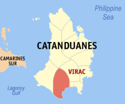
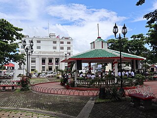
Catanduanes, officially the Province of Catanduanes, is an island province located in the Bicol Region of Luzon in the Philippines. It is the 12th-largest island in the Philippines, and lies to the east of Camarines Sur, across Maqueda Channel. Its capital is Virac. It had a population of 271,879 people as of the 2020 census.

<span class="mw-page-title-main">Tabaco</span> Component city in Albay, Philippines

Tabaco, officially the City of Tabaco, is a 4th class component city in the province of Albay, Philippines. According to the 2020 census, it has a population of 140,961 people.

<span class="mw-page-title-main">Casiguran, Sorsogon</span> Municipality in Sorsogon, Philippines

Casiguran, officially the Municipality of Casiguran, is a 4th class municipality in the province of Sorsogon, Philippines. According to the 2020 census, it has a population of 35,602 people.

<span class="mw-page-title-main">Claveria, Masbate</span> Municipality in Masbate, Philippines

Claveria, officially the Municipality of Claveria, is a 3rd class municipality in the province of Masbate, Philippines. According to the 2020 census, it has a population of 42,142 people. Ranked 592nd among 1,488 municipalities in the Philippines.

<span class="mw-page-title-main">Tiwi, Albay</span> Municipality in Albay, Philippines

Tiwi, officially the Municipality of Tiwi is a 1st class municipality in the Province of Albay, Philippines. According to the 2020 census, it has a population of 56,444 people.

<span class="mw-page-title-main">Bagamanoc</span> Municipality in Catanduanes, Philippines

Bagamanoc, officially the Municipality of Bagamanoc, is a 5th class municipality in the province of Catanduanes, Philippines. According to the 2020 census, it has a population of 11,086 people.

<span class="mw-page-title-main">Baras, Catanduanes</span> Municipality in Catanduanes, Philippines

Baras, officially the Municipality of Baras, is a 5th class municipality in the province of Catanduanes, Philippines. According to the 2020 census, it has a population of 13,484 people.

<span class="mw-page-title-main">Bato, Catanduanes</span> Municipality in Catanduanes, Philippines

Bato, officially the Municipality of Bato, is a 5th class municipality in the province of Catanduanes, Philippines. According to the 2020 census, it has a population of 21,748 people.

<span class="mw-page-title-main">Caramoran</span> Municipality in Catanduanes, Philippines

Caramoran, officially the Municipality of Caramoran, is a 3rd class municipality in the province of Catanduanes, Philippines. According to the 2020 census, it has a population of 32,114 people.

<span class="mw-page-title-main">Gigmoto</span> Municipality in Catanduanes, Philippines

Gigmoto, officially the Municipality of Gigmoto, is a 5th class municipality in the province of Catanduanes, Philippines. According to the 2020 census, it has a population of 8,712 people.

<span class="mw-page-title-main">Pandan, Catanduanes</span> Municipality in Catanduanes, Philippines

Pandan, officially the Municipality of Pandan, is a 4th class municipality in the province of Catanduanes, Philippines. According to the 2020 census, it has a population of 21,473 people.

<span class="mw-page-title-main">Panganiban, Catanduanes</span> Municipality in Catanduanes, Philippines

Panganiban, officially the Municipality of Panganiban, is a 5th class municipality in the province of Catanduanes, Philippines. According to the 2020 census, it has a population of 9,713 people.

<span class="mw-page-title-main">San Andres, Catanduanes</span> Municipality in Catanduanes, Philippines

San Andres, officially the Municipality of San Andres, is a 3rd class municipality in the province of Catanduanes, Philippines. According to the 2020 census, it has a population of 38,480 people.

<span class="mw-page-title-main">San Miguel, Catanduanes</span> Municipality in Catanduanes, Philippines

San Miguel, officially the Municipality of San Miguel, is a 5th class municipality in the province of Catanduanes, Philippines. According to the 2020 census, it has a population of 15,680 people.

<span class="mw-page-title-main">Viga, Catanduanes</span> Municipality in Catanduanes, Philippines

Viga, officially the Municipality of Viga, is a 4th class municipality in the province of Catanduanes, Philippines. According to the 2020 census, it has a population of 22,869 people.

<span class="mw-page-title-main">Aroroy</span> Municipality in Masbate, Philippines

Aroroy, officially the Municipality of Aroroy, is a 1st class municipality in the province of Masbate, Philippines. According to the 2020 census, it has a population of 88,351 people. The town is known for the Kalanay Cave, one of the most important archaeological sites in Masbate province.

<span class="mw-page-title-main">Lagonoy</span> Municipality in Camarines Sur, Philippines

Lagonoy, officially the Municipality of Lagonoy, is a 2nd class municipality in the province of Camarines Sur, Philippines. According to the 2020 census, it has a population of 56,714 people.

<span class="mw-page-title-main">Pamplona, Camarines Sur</span> Municipality in Camarines Sur, Philippines

Pamplona, officially the Municipality of Pamplona, is a 3rd class municipality in the province of Camarines Sur, Philippines. According to the 2020 census, it has a population of 39,333 people.

<span class="mw-page-title-main">Tinambac</span> Municipality in Camarines Sur, Philippines

Tinambac, officially the Municipality of Tinambac, is a 1st class municipality in the province of Camarines Sur, Philippines. According to the 2020 census, it has a population of 70,176 people.

<span class="mw-page-title-main">Jomalig</span> Municipality in Quezon, Philippines

Jomalig, officially the Municipality of Jomalig, is a 5th class municipality in the province of Quezon, Philippines. According to the 2020 census, it has a population of 7,667 people.

References

  1. Municipality of Virac | (DILG)
  2. "2015 Census of Population, Report No. 3 – Population, Land Area, and Population Density" (PDF). Philippine Statistics Authority. Quezon City, Philippines. August 2016. ISSN   0117-1453. Archived (PDF) from the original on May 25, 2021. Retrieved July 16, 2021.
  3. 1 2 3 Census of Population (2020). "Region V (Bicol Region)". Total Population by Province, City, Municipality and Barangay. Philippine Statistics Authority . Retrieved July 8, 2021.
  4. "PSA Releases the 2018 Municipal and City Level Poverty Estimates". Philippine Statistics Authority. December 15, 2021. Retrieved January 22, 2022.
  5. 1 2 "Virac". Philippine Department of Tourism. Retrieved on June 28, 2010.
  6. Yap, Eric (June 30, 2022). "AN ACT AUTOMATICALLY CONVERTING THE CAPITAL TOWN OF PROVINCES WITH NO COMPONENT CITIES, INDEPENDENT COMPONENT CITIES OR HIGHLY URBANIZED CITIES WITHIN ITS TERRITORIAL JURISDICTION, INTO A COMPONENT CITY" (PDF). House of Representatives of the Philippines. Retrieved April 1, 2023.
  7. Palma, Wilter (August 9, 2022). "AN ACT AUTOMATICALLY CONVERTING THE CAPITAL TOWN OF PROVINCES WITH NO COMPONENT CITIES, INDEPENDENT COMPONENT CITIES, OR HIGHLY URBANIZED CITIES WITHIN ITS TERRITORIAL JURISDICTION, INTO A COMPONENT CITY" (PDF). House of Representatives of the Philippines. Retrieved April 1, 2023.
  8. Daza, Paul (August 11, 2022). "AN ACT CONVERING INTO COMPONENT CITIES THE CAPITAL TOWNS OF PROVINCES WITHOUT A CITY, AMENDING FOR THE PURPOSE SECTION 450 OF REPUBLIC ACT NO. 7610, AS AMENDED BY REPUBLIC ACT NO. 9009, OTHERWISE KNOWN AS THE LOCAL GOVERNMENT CODE OF 1991, AND FOR OTHER PURPOSES" (PDF). House of Representatives of the Philippines. Retrieved April 1, 2023.
  9. "Virac, Catanduanes Climatological Normal Values". Philippine Atmospheric, Geophysical and Astronomical Services Administration. Archived from the original on October 18, 2018. Retrieved October 18, 2018.
  10. "Virac, Catanduanes Climatological Extremes". Philippine Atmospheric, Geophysical and Astronomical Services Administration. Archived from the original on October 18, 2018. Retrieved October 18, 2018.
  11. 1 2 "Virac/Catanduanes Archived 2010-06-17 at the Wayback Machine ". Diocese of Virac web page. Retrieved on June 26, 2010.
  12. Census of Population (2015). "Region V (Bicol Region)". Total Population by Province, City, Municipality and Barangay. Philippine Statistics Authority . Retrieved June 20, 2016.
  13. Census of Population and Housing (2010). "Region V (Bicol Region)" (PDF). Total Population by Province, City, Municipality and Barangay. National Statistics Office . Retrieved June 29, 2016.
  14. Censuses of Population (1903–2007). "Region V (Bicol Region)". Table 1. Population Enumerated in Various Censuses by Province/Highly Urbanized City: 1903 to 2007. National Statistics Office.
  15. "Province of Catanduanes". Municipality Population Data. Local Water Utilities Administration Research Division. Retrieved December 17, 2016.
  16. "Poverty incidence (PI):". Philippine Statistics Authority. Retrieved December 28, 2020.
  17. "Estimation of Local Poverty in the Philippines" (PDF). Philippine Statistics Authority. November 29, 2005.
  18. "2003 City and Municipal Level Poverty Estimates" (PDF). Philippine Statistics Authority. March 23, 2009.
  19. "City and Municipal Level Poverty Estimates; 2006 and 2009" (PDF). Philippine Statistics Authority. August 3, 2012.
  20. "2012 Municipal and City Level Poverty Estimates" (PDF). Philippine Statistics Authority. May 31, 2016.
  21. "Municipal and City Level Small Area Poverty Estimates; 2009, 2012 and 2015". Philippine Statistics Authority. July 10, 2019.
  22. "PSA Releases the 2018 Municipal and City Level Poverty Estimates". Philippine Statistics Authority. December 15, 2021. Retrieved January 22, 2022.