
Ürümqi, formerly known as Dihua, is the capital of the Xinjiang Uyghur Autonomous Region in the far northwest of the People's Republic of China. Ürümqi was a major hub on the Silk Road during China's Tang dynasty and developed its reputation as a leading cultural and commercial center during the Qing dynasty in the 19th century.
This article lists extreme locations on Earth that hold geographical records or are otherwise known for their geophysical or meteorological superlatives. All of these locations are Earth-wide extremes; extremes of individual continents or countries are listed in separate articles under the Extreme points by region section. For other lists of extreme places on Earth, see Lists of extreme points. For more detailed meteorological and climatic records, see List of weather records.
This is a list of the extreme points of Ireland – the points that are farthest north, south, east or west in Ireland. It includes the Republic of Ireland and Northern Ireland.
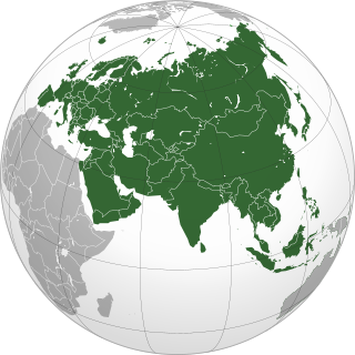
This is a list of the extreme points of Eurasia, the points that are farther north, south, east or west than any other location on the continent. Some of these locations are open to debate, owing to the diverse definitions of Europe and Asia.
The extreme points of South America are the points that are farther north, south, east or west than any other location on the continent. The continent's southernmost point is often said to be Cape Horn, but Águila Islet of the Diego Ramírez Islands lies further south.
The time in China follows a single standard time offset of UTC+08:00, even though China spans almost five geographical time zones. The official national standard time is called Beijing Time domestically and China Standard Time (CST) internationally. Daylight saving time has not been observed since 1991.

Ulugqat County is a county in Xinjiang Uygur Autonomous Region, China. It is under the administration of the Kyrgyz autonomous prefecture of Kizilsu. The county has two towns, nine townships and one state-owned farm, eight communities and 34 villages under its jurisdiction in 2017, its county seat is Wuqia Town. It contains an area of 19,118.11 km2 (7,381.54 sq mi) and has a population of 56,633 with main ethnic groups of Kyrgyz, Han and Uyghur peoples.
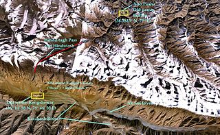
Hindu-tagh Pass, also known as Hindutash, is a historical mountain pass in the western Xinjiang, China. The pass cuts through the Kunlun Mountains connecting the now-deserted town of Kangxiwar in the Karakash River valley to the town of Pusha in the Pusha Jilga valley. It also connects to the road to the city of Hotan.
This is a list of points in the Philippines that are farther north, south, east, or west than any other location in the country. Also included are extreme points in elevation, extreme distances, and other points of geographic interest.
This is an article about the extreme points of Indonesia.

Erkeshtam, also Irkeshtam or Erkech-Tam, is a border crossing between Kyrgyzstan and Xinjiang, China, named after a village on the Kyrgyz side of the border in southern Osh Region. The border crossing is also called Simuhana (斯姆哈纳), after the first settlement on the Chinese side of the border, but Erkeshtam is now the more common name used in both countries.
This is a list of the extreme points and extreme elevations in Wales.

Fuyuan is a county-level city of the province of Heilongjiang, China. It is under the jurisdiction of the prefecture-level city of Jiamusi.
Xinjiang, officially the Xinjiang Uyghur Autonomous Region (XUAR), is a province-level administrative autonomous region of China.
Ulugqat Township is a township of Ulugqat County (Wuqia) in Kizilsu Kyrgyz Autonomous Prefecture, Xinjiang Uygur Autonomous Region, China. Located in the middle north of the county, the township covers an area of 3,430 square kilometers with a population of 4,430. It has 4 villages under its jurisdiction. Its seat is at Korgan Village (库尔干村).
Oksalur Township is a township of Ulugqat County (Wuqia) in Kizilsu Kyrgyz Autonomous Prefecture, Xinjiang Uygur Autonomous Region, China. Located in the southwest of the county, the township covers an area of 1,745.5 square kilometers with a population of 1,031. It has 2 villages under its jurisdiction. Its seat is at Qat Village (恰提村).
Jigin Township is considered to be the westernmost township of China located in Ulugqat County (Wuqia), Kizilsu Kyrgyz Autonomous Prefecture, Xinjiang Uygur Autonomous Region. The township covers an area of 1,452 square kilometers. It has four villages under its jurisdiction and its seat is at Saz Village (萨孜村).
Kiziloy Township is the former county seat before 1989 and a township of Wuqia County in Xinjiang Uygur Autonomous Region, China. Located in the middle of the county, the township covers an area of 2,782.4 square kilometers with a population of 6,899. It has 6 administrative villages under its jurisdiction. Its seat is at Kiziloy (黑孜苇).

