List of offshore wind farms in the Baltic Sea

Last updated

Map all coordinates using: OpenStreetMap  
Download coordinates as: KML
Lillgrund Wind Farm in Sweden Turbiny wiatrowe w Szwecji, 2011 ubt.JPG
Lillgrund Wind Farm in Sweden

This is a complete list of operational, offshore wind farms in the Baltic Sea and connected areas such as Kattegat and Danish straits.

Contents

This information is gathered from multiple Internet sources, [1] and primarily the 4C Offshore's Global Offshore Wind Farm Map and Database and is current up to February 2015. The name of the Wind Farm is the name used by the Energy Company when referring to the Farm and is usually related to a shoal or the name of the nearest town on shore. The Wind Farm part is implied and hence removed for clarity.

The list is sorted by capacity, but it can be sorted in any way by clicking the symbol >< at the top in each column.

Wind farm
Country
Location
Turbines
Build cost
Depth range (m)
km to shore
Owner
References
Kriegers Flak Flag of Denmark.svg  Denmark 55°01′00″N12°56′00″E / 55.01667°N 12.93333°E / 55.01667; 12.93333 (Kriegers Flak 604 W) 604.872 x Siemens Gamesa SWT-8.4-16720210.372 DKK/kWh15-3025 Vattenfall [w 1] [2] [3]
Anholt Flag of Denmark.svg  Denmark 56°36′00″N11°12′36″E / 56.60000°N 11.21000°E / 56.60000; 11.21000 (Anholt 400 W) 400111 × Siemens SWT-3.6-1202013 1350m1520 Ørsted [w 2] [4]
EnBW Baltic 2 Flag of Germany.svg  Germany 55°00′00″N13°12′00″E / 55.00000°N 13.20000°E / 55.00000; 13.20000 (EnBW Baltic 2 288 W) 28880 × Siemens SWT 3.6-1202015 1250m23-4432 EnBW [w 3] [5]
Rødsand II Flag of Denmark.svg  Denmark 54°33′36″N11°33′0″E / 54.56000°N 11.55000°E / 54.56000; 11.55000 (Rødsand II 207 W) 20790 × Siemens SWP 2.3-932010 400m6-129 E.ON [w 4] [6] [7] [8] [9]
Nysted (Rødsand I) Flag of Denmark.svg  Denmark 54°33′0″N11°42′36″E / 54.55000°N 11.71000°E / 54.55000; 11.71000 (Nysted (Rødsand I) 166W) 16672 × Siemens SWP 2.3-822003 248m36%6-911 Ørsted 50%, PensionDanmark 50% [w 5] [10] [11] [9] [12]
Lillgrund Flag of Sweden.svg  Sweden 55°31′0″N12°47′0″E / 55.51667°N 12.78333°E / 55.51667; 12.78333 (Lillgrund 110W) 11048 × Siemens SWP 2.3-932008 197m4-139 Vattenfall [w 6] [13] [14]
EnBW Baltic 1 Flag of Germany.svg  Germany 54°36′36″N12°39′0″E / 54.61000°N 12.65000°E / 54.61000; 12.65000 (EnBW Baltic 1 48.3 W) 48.3 21 × Siemens SWT 2.3-932011 200m16-1916 EnBW [w 7] [15] [16]
Karehamn Flag of Sweden.svg  Sweden 56°58′48″N17°01′12″E / 56.98000°N 17.02000°E / 56.98000; 17.02000 (Karehamn 48 W) 48 16 × Vestas V112-3.0MW2013 120m215 E.ON [17]
Middelgrunden Flag of Denmark.svg  Denmark 55°41′27″N12°40′13″E / 55.69083°N 12.67028°E / 55.69083; 12.67028 (Middelgrunden 40 W) 40 20 × Bonus/Siemens 2MW2000 47m26%3-64.750% private, 50% Ørsted [w 8] [10] [11] [18] [19] [9]
Kemi Ajos I + II Flag of Finland.svg  Finland 65°39′18″N24°30′47″E / 65.65500°N 24.51306°E / 65.65500; 24.51306 (Kemi Ajos I + II 30 W) 30 10 × WinWinD 3MW2008 50m1-73Pohjolan Voima [w 9] [20]
Samsø Flag of Denmark.svg  Denmark 55°43′12″N10°34′48″E / 55.72000°N 10.58000°E / 55.72000; 10.58000 (Samsø 23 W) 23 10 × Bonus/Siemens 2.3-822003 30m39%10-134Municipal, private [w 10] [9] [10] [11] [21]
Sprogø Flag of Denmark.svg  Denmark 55°20′24″N10°57′36″E / 55.34000°N 10.96000°E / 55.34000; 10.96000 (Sprogø 21 W) 21 7 × Vestas V90-3MW2009 34%6-1610 Great Belt Link [9] [10] [11] [22]
Utgrunden Flag of Sweden.svg  Sweden 56°20′38″N16°16′48″E / 56.34389°N 16.28000°E / 56.34389; 16.28000 (Utgrunden 11W) 11 7 × Enron Wind (GE) 70 / 1.5MW2000 £12m6-154-7 Vattenfall [23]
Yttre Stengrund (dismantled)Flag of Sweden.svg  Sweden 56°10′0″N16°1′16″E / 56.16667°N 16.02111°E / 56.16667; 16.02111 (Yttre Stengrund 10W) 10 5 × NEG Micon 2MW (Vestas)2001-2015 13m6-82-4 Vattenfall [24]
Frederikshavn Flag of Denmark.svg  Denmark 57°26′40″N10°33′40″E / 57.44444°N 10.56111°E / 57.44444; 10.56111 (Frederikshavn 7.6 W) 7.6 Nordex N90 2.3 MW, Vestas V90-3MW,
Bonus(Siemens) 82.4 2.3 MW
2003 29%1-40.3 Ørsted [9] [10] [11] [25]
Avedøre Holme Flag of Denmark.svg  Denmark 55°36′00″N12°27′36″E / 55.60000°N 12.46000°E / 55.60000; 12.46000 (Avedøre Holme 11 W) 11 3 × Siemens SWT-3.6-1202009 30%20.5 Ørsted [w 11] [4]
Tunø Knob Flag of Denmark.svg  Denmark 55°58′10″N10°21′20″E / 55.96944°N 10.35556°E / 55.96944; 10.35556 (Tunø Knob 5 W) 510 × Vestas V39 500kW1995 £10m30%3-76 Ørsted [9] [10] [11] [26] [27]
Vindeby (dismantled)Flag of Denmark.svg  Denmark 54°58′12″N11°7′48″E / 54.97000°N 11.13000°E / 54.97000; 11.13000 (Vindeby 4.95 W) 4.95 11 × Bonus 450kW offshore1991-2017 10m24%2-41.8SEAS/Bonus Energy [9] [10] [11] [28] [29]
Bockstigen Flag of Sweden.svg  Sweden 57°2′0″N18°9′0″E / 57.03333°N 18.15000°E / 57.03333; 18.15000 (Bockstigen 2.75W) 2.75 5 × WinWorld 550kW1998 4m5-64-6 Vattenfall [30]


  • "Cap." is the rated nameplate capacity of the wind farm
  • " When " is the year when the windfarm was or will be commissioned and put into service.
  • "Cost" is the total capital cost of the project up to commissioning.
  • "Cap. Fac." is the average capacity factor, i.e. the average power generated by the windfarm, as a percentage of its nameplate capacity.
  • "km to shore" is the average distance of the windfarm to shore, or (where available) the distance from the in-farm transformer/substation to the shore
  • "Depth range (m)" is the range of minimum to maximum depths of water that the windfarm is sited in
  • "Refs" cite the source references for the information. The [w ...] footnotes link to each windfarm's own home page
Relief Map of Baltic Sea.png
Red pog.svg
Anholt
Red pog.svg
EnBW Baltic 2
Red pog.svg
Anholt
Red pog.svg
Rødsand II
Red pog.svg
Nysted (Rødsand I)
Red pog.svg
Lillgrund
Red pog.svg
EnBW Baltic 1
Red pog.svg
Karehamn
Red pog.svg
Middelgrunden
Red pog.svg
Kemi Ajos I+II
Red pog.svg
Samsø
Red pog.svg
Sprogø
Red pog.svg
Utgrunden
Red pog.svg
Yttre Stengrund
Red pog.svg
Frederikshavn
Red pog.svg
Avedøre Holme
Red pog.svg
Tunø Knob
Red pog.svg
Vindeby
Red pog.svg
Bockstigen
Locations of offshore wind farms in the Baltic Sea

Wind farm home pages

Middelgrunden turbines in Oresund DanishWindTurbines.jpg
Middelgrunden turbines in Øresund
  1. "Kriegers Flak Offshore Wind Farm". Archived from the original on 2016-06-29. Retrieved 2015-10-29.
  2. Anholt offshore wind farm Archived 2014-12-30 at the Wayback Machine
  3. EnBW Baltic 2
  4. "Rødsand II". Archived from the original on 2011-02-10. Retrieved 2010-10-28.
  5. Nysted offshore wind farm
  6. Lillgrund
  7. Baltic 1
  8. Middelgrunden Wind Turbine Cooperative Current turbine data Archived 2008-09-08 at the Wayback Machine
  9. "WinWind" (PDF). Archived from the original (PDF) on 2009-04-19. Retrieved 2010-10-28.
  10. Samsø Sea Wind
  11. Avedøre offshore wind farm

See also

Related Research Articles

<span class="mw-page-title-main">Samsø</span> Danish Island

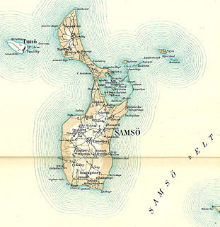
Samsø is a Danish island in the Kattegat 15 kilometers (9.3 mi) off the Jutland Peninsula. Samsø is located in Samsø municipality. The community has 3,724 inhabitants (2017) called Samsings and is 114 km² in area. Due to its central location, the island was used during the Viking Age as a meeting place. The etymology of the island's name is unknown.

<span class="mw-page-title-main">Horns Rev</span>

Horns Rev is a shallow sandy reef of glacial deposits in the eastern North Sea, about 15 km (9.3 mi) off the westernmost point of Denmark, Blåvands Huk. The reef contains the Horns Rev Offshore Wind Farm.

Ørsted A/S is a Danish multinational power company based in Fredericia, Denmark. It is the largest energy company in Denmark. The company adopted its current name on 6 November 2017.

<span class="mw-page-title-main">Tunø</span> Danish island in the Kattegat

Tunø is a Danish island in the Kattegat, approximately 4 km west of the neighbouring island of Samsø. The island covers an area of 3.52 square kilometres, has a circumference of 9.5 km (5.9 mi) and has total of 66 inhabitants as of November 2022. It comes under the administration of Odder municipality. Tunø By is the only village on the island, with the hamlet of Løkkegårde as the second most populated area.

EnBW Energie Baden-Württemberg AG, or simply EnBW, is a publicly-traded energy company headquartered in Karlsruhe, Germany. As its name indicates, EnBW is based in the German state of Baden-Württemberg.

<span class="mw-page-title-main">Wind power in Denmark</span> Overview of wind power in Denmark

Denmark was a pioneer in developing commercial wind power during the 1970s, and today a substantial share of the wind turbines around the world are produced by Danish manufacturers such as Vestas—the world's largest wind-turbine manufacturer—along with many component suppliers. In Denmark's electricity sector wind power produced the equivalent of 47% of Denmark's total electricity consumption in 2019, an increase from 43.4% in 2017, 39% in 2014, and 33% in 2013. In 2012, the Danish government adopted a plan to increase the share of electricity production from wind to 50% by 2020, and to 84% by 2035. Denmark had the 4th best energy architecture performance in the world in 2017 according to the World Economic Forum, and the second best energy security in the world in 2019 according to the World Energy Council.

<span class="mw-page-title-main">Nysted Wind Farm</span>

The Nysted Wind Farm is a Danish offshore wind farm close to the Rødsand sand bank near Lolland. Gravity base foundations are used rather than piles due to ice conditions.

<span class="mw-page-title-main">Middelgrunden wind farm</span>

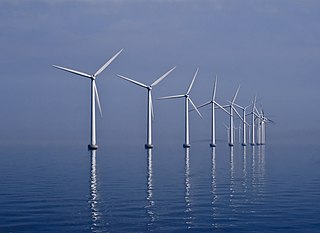
The Middelgrunden wind farm stands on the shoal Middelgrunden, between shipping lanes in the Øresund, 3.5 km outside Copenhagen, Denmark. When it was built in 2000, it was the world's largest offshore farm, with 20 turbines and a capacity of 40 MW. The farm delivers about 4% of the power for Copenhagen.

<span class="mw-page-title-main">Baltic 1 Offshore Wind Farm</span>

EnBW Baltic 1 is the first commercial offshore wind farm of Germany in the Baltic Sea. Siemens supplied 21 SWT 2.3-93 wind turbines for the 48.3 megawatt wind farm. EnBW Baltic 1 is located about 16 kilometres (9.9 mi) north of the Darss-Zingst Peninsula and covers about seven square kilometers. Work started in July 2010; the wind farm was officially commissioned on 2 May 2011.

<span class="mw-page-title-main">Blyth Offshore Wind Farm</span>

Blyth Offshore Wind Farm was a small coastal wind farm located 0.5 miles (0.80 km) off the coast of Blyth, Northumberland, England.

<span class="mw-page-title-main">Anholt Offshore Wind Farm</span>

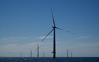
Anholt Offshore Wind Farm is a Danish offshore wind power wind farm in the Kattegat, between Djursland and Anholt island. With a nameplate capacity of 400 megawatts (MW), it is one of the largest offshore wind farm in the world and was the largest in Denmark from 2013 to 2019. A cable from the wind farm to Anholt replaces most of the diesel-powered electricity on the island.

Bladt Industries A/S is an international steel contractor specialising in large-scale and highly complex steel structures. Bladt Industries operate within three key areas of business providing steel solutions for the wind and renewable energy sector, for the oil and gas industry and for infrastructure. Bladt Industries was established in 1965 as the company Jørgen Bladt A/S.

Vindeby Offshore Wind Farm was the first offshore wind farm in the world, erected in 1991 off the coast of the town of Vindeby on the Danish island of Lolland. It was decommissioned for cost reasons in 2017 after 25 years of useful life.

<span class="mw-page-title-main">Tunø Knob Offshore Wind Farm</span>

Tunø Knob Offshore Wind Farm is an offshore wind farm in the Bay of Aarhus, Denmark. It is located on the sandbar Tunø Knob, west of the Tunø island.

<span class="mw-page-title-main">Avedøre Holme Offshore Wind Farm</span>

Avedøre Holme Offshore Wind Farm is a nearshore wind farm right off the coast of Avedøre, Copenhagen. It was commissioned in 2009 with three 3.6 MW Siemens turbines as a demonstrator project for future offshore wind turbines. Ørsted owns two turbines, and a private collective owns the third. Ørsted and partners build a 2MW hydrogen electrolysis station at Avedøre Power Station supplied by Ørsted's two turbines.

<span class="mw-page-title-main">Baltic 2 Offshore Wind Farm</span>

EnBW Baltic 2 is an offshore wind farm in the German section of the Kriegers Flak reef in the Baltic Sea. The wind farm uses 80 Siemens SWT 3.6-120 wind turbines for a total capacity of 288 megawatt. Baltic 2 is connected to Germany via Baltic 1, but is also connected to Denmark via the adjacent offshore wind farm ″Kriegers Flak″ in 2020, creating a 400 MW AC offshore grid synchronized to the east Denmark network. The cable to Denmark costs €350m, of which €150m comes from the EU.

<span class="mw-page-title-main">Horns Rev Offshore Wind Farm</span> Group of Danish offshore wind farms in the North Sea

Horns Rev is an offshore wind farm in Danish waters in the North Sea.

References

  1. Steve Kopits and Adam Westwood. Offshore Wind: Time for a Market Take-off? Renewable Energy World, 8 October 2009, Table 1.
  2. Kriegers Flak (Denmark) offshore wind farm 4C . Retrieved: 29 October 2015.
  3. Wittrup, Sanne. "Danmark tiltrækker masser af nye konsortier til kæmpe havmøllepark " Ingeniøren , 28 October 2015. Accessed: 28 October 2015.
  4. 1 2 Anholt (Denmark) offshore wind farm 4C. Retrieved: 17 February 2015.
  5. "EnBW Baltic 2". 4C Offshore. Retrieved 17 February 2015.
  6. "Rødsand 2 wind farm online". The Copenhagen Post . 13 October 2010. Archived from the original on 16 October 2010. Retrieved 14 October 2010.
  7. Rødsand II Wind Farm, Denmark Power Technology. Retrieved: 9 November 2010.
  8. Rødsand II (Denmark) offshore wind farm 4C . Retrieved: 8 August 2010.
  9. 1 2 3 4 5 6 7 8 Spliid, Iben B. Data on operating and decommissioned wind turbines (as at end of September 2010) Archived 2011-07-19 at the Wayback Machine (.xls spreadsheet) Danish Energy Agency , 18 October 2010. Main page Archived 2013-04-15 at the Wayback Machine Retrieved: 25 October 2010.
  10. 1 2 3 4 5 6 7 Operational offshore wind farms in Europe, end 2009 EWEA . Retrieved: 23 October 2010.
  11. 1 2 3 4 5 6 7 Christensen, Allan S. & Madsen, Morten. Supply Chain study on the Danish offshore wind industry Archived 2016-05-15 at the Portuguese Web Archive page 33-42 Offshore Center Denmark, 29. august 2005. Retrieved: 23 October 2010.
  12. Rødsand 1 4C . Retrieved: 31 July 2010.
  13. Offshore Windfarm Lillgrund, Sweden Power Technology. Retrieved: 9 November 2010.
  14. Lillgrund (Sweden) offshore wind farm 4C . Retrieved: 19 August 2010.
  15. "Datasheet for site: Baltic 1 Offshore Wind Farm". LORC - Lindoe Offshore Renewables Center. Retrieved 11 July 2011.
  16. "EnBW Baltic 1". 4C Offshore. Retrieved 11 July 2011.
  17. Kårehamn (Sweden) offshore wind farm 4C. Retrieved: 17 February 2015.
  18. Middelgrunden Offshore Wind Farm, Denmark Power Technology. Retrieved: 9 November 2010.
  19. Middelgrunden (Denmark) offshore wind farm 4C . Retrieved: 8 August 2010.
  20. Kemi Ajos I Kemi Ajos II (Finland) offshore wind farm 4C . Retrieved: 27 October 2010.
  21. Samsø Havvind (Denmark) offshore wind farm 4C . Retrieved: 8 August 2010.
  22. Sprogø (Denmark) offshore wind farm 4C . Retrieved: 8 August 2010.
  23. Utgrunden 1 (Sweden) offshore wind farm Archived 2012-03-14 at the Wayback Machine 4C . Retrieved: 19 August 2010.
  24. Yttre Stengrund (Sweden) offshore wind farm 4C . Retrieved: 19 August 2010.
  25. 4cOffshore listing for Frederikshavn
  26. Tunø Offshore wind energy listing
  27. 4cOffshore listing for Tunø Knob
  28. Stenstrop, Georg. Vindeby Kulturarv. Retrieved: 1 September 2010.
  29. 4cOffshore listing for Vindeby
  30. Bockstigen (Sweden) offshore wind farm 4C . Retrieved: 19 August 2010.