List of places with columnar jointed volcanics

Last updated
Basalt columns seen on Porto Santo Island, Portugal BasaltColumns PortoSanto.JPG
Basalt columns seen on Porto Santo Island, Portugal

Columnar jointing of volcanic rocks exists in many places on Earth. Perhaps the most famous basalt lava flow in the world is the Giant's Causeway in Northern Ireland, in which the vertical joints form polygonal columns and give the impression of having been artificially constructed.

Contents

Notable columnar jointed volcanics

Africa

Asia

Garni Gorge, Armenia Garni Gorge Armenia axxp.JPG
Garni Gorge, Armenia
Curved columns of rhyolitic tuff at the Hong Kong High Island Reservoir S-Basalt.JPG
Curved columns of rhyolitic tuff at the Hong Kong High Island Reservoir
Interlocked basaltic columns at the top of Kavadia mountain at Dewas district in India. Interlocked basaltic columns at of Kavadia mountain.jpg
Interlocked basaltic columns at the top of Kavadia mountain at Dewas district in India.
Columnar basalts at Cape Stolbchatiy, Kuril Islands, Russia Cape Stolbchaty.jpg
Columnar basalts at Cape Stolbchatiy, Kuril Islands, Russia

Armenia

China (mainland)

  • Heiyuhe Columnar Joints (黑鱼河柱状节理) [Xianrenqiao (仙人桥)], Longchuan River (龙川江) & Black Fish River, Tengchong

Hong Kong

  • Basalt Island area, Hong Kong; including High Island Reservoir area, Hong Kong; although the High Island Reservoir is not basalt but rhyolitic tuff, rich in potash feldspar and quartz phenocrysts.

India

In India, columnars are found in several places across the volcanic traps such as 6.5 crore or 65 million years ago (Mya) old deccan traps in South India and 14.5 crore or 145 mya old Rajmahal Traps in Eastern India.

Karnataka
Madhya Pradesh
  • Kavadia Pahad columnars: Forest area near Bagli & Pipari village of Dewas District in Madhya Pradesh. The rock formation is at Kavadia Pahad which is a series of seven mountain ranges. [5]
  • Linga columnars: 11 kilometres (6.8 mi) south of Chhindwara city.
  • Narsinghpur columnar joints in Deccan Basalts near Narsinghpur.
Maharashtra
Telangana

Indonesia

Close up view of stones atop Gunung Padang Situs Megalitikum Gunung Padang, Cianjur - panoramio (11).jpg
Close up view of stones atop Gunung Padang
Panorama atop Gunung Padang Gunung Padang Scenery.jpg
Panorama atop Gunung Padang

Iran

Japan

Malaysia

at Kg Balung Cocos, Tawau, Sabah Basalt Columns .jpg
at Kg Balung Cocos, Tawau, Sabah
Basalt Columns exposed along a river in a remote place in Tawau, Malaysia Teck Guan Cocoa Village Columnar Basalt.jpg
Basalt Columns exposed along a river in a remote place in Tawau, Malaysia
  • In Teck Guan Cocoa Village and in Giram River, Kampung Balung Cocos Tawau, Sabah, Malaysia.

Mongolia

Philippines

Russia

South Korea

Syria / Israel (disputed)

Meshushim River, with prominent hexagonal basalt columns 6-4012-102 - Meshushim (Hexagons) and the river from up - mSHvSHy hbzlt vnKHl hmSHvSHym mlm`lh.jpg
Meshushim River, with prominent hexagonal basalt columns

Taiwan

Thailand

Turkey

Vertically jointed columnar basalt of Basalt Rocks Natural Monument in Turkey Boyabat.jpg
Vertically jointed columnar basalt of Basalt Rocks Natural Monument in Turkey

Vietnam

The Cliff of Stone Plates (Ganh Da Dia) near Tuy Hoa city, Phu Yen Province, Vietnam Ganh Da Dia.jpg
The Cliff of Stone Plates (Gành Đá Đĩa) near Tuy Hòa city, Phú Yên Province, Vietnam

Europe

Basalt columns in the Rhon, North Bavaria, Germany Basalt columns, Rhon, Germany.JPG
Basalt columns in the Rhön, North Bavaria, Germany
Volcanic rock columns, Milos, Greece Milos basalts.JPG
Volcanic rock columns, Milos, Greece
Ponta da Ajuda, Azores, Portugal Ponta da Ajuda, Azores.jpg
Ponta da Ajuda, Azores, Portugal
Basalt rocks near Detunata Goala east of Bucium, Romania DetunataGoala.jpg
Basalt rocks near Detunata Goală east of Bucium, Romania
Columnar jointing in the basalt of the Giant's Causeway in Northern Ireland Giants-causeway-in-ireland.jpg
Columnar jointing in the basalt of the Giant's Causeway in Northern Ireland
Fingal's Cave, Staffa Island, Scotland Fingal's Cave on Staffa Island - panoramio (4).jpg
Fingal's Cave, Staffa Island, Scotland

Czech Republic

Faroe Islands

France

Georgia

Germany

Greece

Hungary

  • Badacsony
  • Bér
  • Szanda
  • Szilváskő
  • Hegyestű
  • Szent-György-hegy
  • Gulács
  • Haláp
  • Hajagos
  • Uzsa

Iceland

Italy

Portugal

Romania

Slovakia

  • Šomoška

Spain

Sweden

Ukraine

United Kingdom

North and Central America

Columnar jointing in the basalt of the Pain de sucre (sugar loaf) in les Saintes, Guadeloupe Orgues du pain de sucre.jpg
Columnar jointing in the basalt of the Pain de sucre (sugar loaf) in les Saintes, Guadeloupe
La Concepcion, Aculco, Mexico La Concepcion, Aculco.jpg
La Concepción, Aculco, México
Basalt columns in the Mascota River, Mexico Basalt columns in the Mascota River, Mexico.jpg
Basalt columns in the Mascota River, Mexico
Basaltic Prisms of Santa Maria Regla in Huasca de Ocampo, Hidalgo Prismas Basalticos, Huasca de Ocampo, Hidalgo, Mexico, 2013-10-10, DD 06.JPG
Basaltic Prisms of Santa María Regla in Huasca de Ocampo, Hidalgo
Columnar basalt at Devil's Postpile in California Columnar Basalt Devil's Postpile California.JPG
Columnar basalt at Devil's Postpile in California
Devils Tower, Wyoming Crook County, WY, USA - panoramio (14).jpg
Devils Tower, Wyoming

Canada

Costa Rica

  • Bajo Rodriguez, San Lorenzo de San Ramon

El Salvador

  • Cascada Los Tercios, Suchitoto
  • Concepción waterfall, Aculco

Greenland

  • Qeqertarsuaq, Disko Island [21]

Guadeloupe

Mexico

Panama

  • Los Ladrillos, Boquete

United States

Oceania

Cape Raoul, Tasmania CAPE RAOUL - TASMAN NATIONAL PARK.jpg
Cape Raoul, Tasmania
Blackhead, Dunedin, New Zealand Columnar basalt, Blackhead, New Zealand.jpg
Blackhead, Dunedin, New Zealand

Australia

Federated States of Micronesia

New Zealand

South America

Beyond Earth

Columnar jointed rocks in unnamed crater wall, Marte Vallis region, Mars. Image courtesy of the High Resolution Imaging Science Experiment, Arizona State University. Martevallis hir 2007304 lrgMod1.png
Columnar jointed rocks in unnamed crater wall, Marte Vallis region, Mars. Image courtesy of the High Resolution Imaging Science Experiment, Arizona State University.

Several exposures of columnar jointing have been discovered on the planet Mars by the High Resolution Imaging Science Experiment (HiRISE) camera, which is carried by the Mars Reconnaissance Orbiter (MRO). Notable among them are formations in the Marte Vallis. [37]

Uses

A view of Gunung Padang Gunung Padang 5th terrace.jpeg
A view of Gunung Padang

A likely Hindu-origin ancient site at Gunung Padang in West Java, Indonesia was built by horizontally laying basalt columns to form terraces on the slope of a hill and creating open-roofed chambers by erecting vertical columns. A now-ruined thirteenth-century religious complex called Nan Madol was built using columnar basalt quarried from various locations on the island of Pohnpei in Micronesia.

Hexagonal basalt was used to build retaining walls by early settlers in some places around Dunedin in New Zealand.

See also

Related Research Articles

<span class="mw-page-title-main">Staffa</span> Island of the Inner Hebrides in Argyll and Bute, Scotland

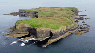
Staffa is an island of the Inner Hebrides in Argyll and Bute, Scotland. The Vikings gave it this name as its columnar basalt reminded them of their houses, which were built from vertically placed tree-logs.

<span class="mw-page-title-main">Cliff</span> Tall, near vertical rock face

In geography and geology, a cliff is an area of rock which has a general angle defined by the vertical, or nearly vertical. Cliffs are formed by the processes of weathering and erosion, with the effect of gravity. Cliffs are common on coasts, in mountainous areas, escarpments and along rivers. Cliffs are usually composed of rock that is resistant to weathering and erosion. The sedimentary rocks that are most likely to form cliffs include sandstone, limestone, chalk, and dolomite. Igneous rocks such as granite and basalt also often form cliffs.

<span class="mw-page-title-main">Devils Postpile National Monument</span> National monument in California, United States

Devils Postpile National Monument is a U.S. National Monument located near Mammoth Mountain in Eastern California. The monument protects Devils Postpile, an unusual rock formation of columnar basalt, "all closely and perfectly fitted together like a vast mosaic." The monument encompasses 798 acres (323 ha) and includes two main attractions: the Devils Postpile formation and Rainbow Falls, a waterfall on the Middle Fork of the San Joaquin River. In addition, the John Muir Trail and Pacific Crest Trail merge into one trail as they pass through the monument. Excluding a small developed area containing the monument headquarters, visitor center and a campground, the National Monument lies within the borders of the Ansel Adams Wilderness.

<span class="mw-page-title-main">Quảng Ninh province</span> Province of Vietnam

Quảng Ninh or Quangninh is a province along the northeastern coast of Vietnam. It is about 153 km (95 mi) east of Hanoi, comprising four cities, two district-level towns and seven rural districts. The provincial capital is Hạ Long. The province covers an area of 6,207.95 km2 (2,396.90 sq mi) and, as of 2023, had a population of 1,413,452. Nearly 80% of the province is mountainous with abundant land, forest, water and mineral resources, with 90% of Vietnam's coal output extracted from the province. The province is also home to Hạ Long Bay, a World Heritage Site that has 1,969 islands, out of which 989 have been given names.

<span class="mw-page-title-main">Latourell Falls</span> Waterfall in Oregon, United States

Latourell Falls is a waterfall along the Columbia River Gorge in the U.S. state of Oregon, within Guy W. Talbot State Park.

<span class="mw-page-title-main">Phú Yên province</span> Province of Vietnam

Phú Yên is a central coastal province in the South Central Coast region, in Central Vietnam. It borders Bình Định to the north, Khánh Hòa to the south, Gia Lai to the northwest, Đắk Lắk to the southwest and the East Sea to the east.

<span class="mw-page-title-main">Trap rock</span> Dark-colored, fine-grained, non-granitic igneous rock

Trap rock, also known as either trapp or trap, is any dark-colored, fine-grained, non-granitic intrusive or extrusive igneous rock. Types of trap rock include basalt, peridotite, diabase, and gabbro. Trap is also used to refer to flood (plateau) basalts, e.g. the Deccan Traps and Siberian Traps. The erosion of trap rock created by the stacking of successive lava flows often created a distinct stairstep landscape from which the term trap was derived from the Swedish word trappa, which means "stairway".

<span class="mw-page-title-main">Hoodoo Mountain</span> Stratovolcano in British Columbia, Canada

Hoodoo Mountain, sometimes referred to as Hoodoo Volcano, is a potentially active stratovolcano in the Northern Interior of British Columbia, Canada. It is located 25 kilometres northeast of the Alaska–British Columbia border on the north side of the Iskut River opposite of the mouth of the Craig River. With a summit elevation of 1,850 metres and a topographic prominence of 900 metres, Hoodoo Mountain is one of many prominent peaks within the Boundary Ranges of the Coast Mountains. Its flat-topped summit is covered by an ice cap more than 100 metres thick and at least 3 kilometres in diameter. Two valley glaciers surrounding the northwestern and northeastern sides of the mountain have retreated significantly over the last hundred years. They both originate from a large icefield to the north and are the sources of two meltwater streams. These streams flow along the western and eastern sides of the volcano before draining into the Iskut River.

<span class="mw-page-title-main">Geology of the Pacific Northwest</span> Geology of Oregon and Washington (United States) and British Columbia (Canada)

The geology of the Pacific Northwest includes the composition, structure, physical properties and the processes that shape the Pacific Northwest region of North America. The region is part of the Ring of Fire: the subduction of the Pacific and Farallon Plates under the North American Plate is responsible for many of the area's scenic features as well as some of its hazards, such as volcanoes, earthquakes, and landslides.

<span class="mw-page-title-main">Granite Mountain (Arizona)</span> Landform in Yavapai County, Arizona, United States

Granite Mountain is a 7,628-foot (2,325 m) mountain located in Yavapai County, Arizona that covers roughly 12 square miles (31 km2). It was once known as Mount Gurley, for the first governor of the Arizona Territory, John A. Gurley. Its southwest face has a sheer granite cliff approximately 500 feet high that is one of the best locations for rock climbing in the state of Arizona. It is located in the Granite Mountain Wilderness, which is managed as a part of the Prescott National Forest. The mountain stands at the northern end of the Sierra Prietas, and borders Skull Valley on the west, on the northwest by the Santa Maria Mountains, and east by the Williamson Valley.

<span class="mw-page-title-main">North Mountain (Nova Scotia)</span> Mountain range in Nova Scotia, Canada

North Mountain is a narrow southwest-northeast trending volcanic ridge on the mainland portion of southwestern Nova Scotia, stretching from Brier Island to Cape Split. It forms the northern edge of the Annapolis Valley along the shore of the Bay of Fundy. Together with South Mountain, the two ranges form the Annapolis Highlands region.

<span class="mw-page-title-main">Columnar jointing</span> Polygonal stone columns

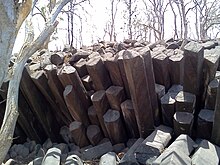
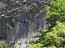
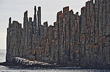
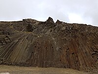
Columnar jointing is a geological structure where sets of intersecting closely spaced fractures, referred to as joints, result in the formation of a regular array of polygonal prisms, or columns. Columnar jointing occurs in many types of igneous rocks and forms as the rock cools and contracts. Columnar jointing can occur in cooling lava flows and ashflow tuffs (ignimbrites), as well as in some shallow intrusions. Columnar jointing also occurs rarely in sedimentary rocks, due to a combination of dissolution and reprecipitation of interstitial minerals by hot, hydrothermal fluids and the expansion and contraction of the rock unit, both resulting from the presence of a nearby magmatic intrusion.

<span class="mw-page-title-main">Tuy An district</span>

Tuy An is a district (huyện) of Phú Yên province in the South Central Coast region of Vietnam.

<span class="mw-page-title-main">Sheepeater Cliff</span> Rock formation in the United States

The Sheepeater Cliffs are a series of exposed cliffs made up of columnar basalt in Yellowstone National Park in the United States. The lava was deposited about 500,000 years ago during one of the periodic basaltic floods in Yellowstone Caldera, and later exposed by the Gardner River. The cliffs are noted as a textbook example of a basaltic flow with well defined joints and hexagonal columns. They were named after a band of Eastern Shoshone known as Tukuaduka. Many of the exposed cliffs are located along a steep inaccessible canyon cut by the Gardner near Bunsen Peak, but some of the cliffs located just off the Grand Loop Road can be reached by car.

<span class="mw-page-title-main">Mess Lake Lava Field</span>

The Mess Lake Lava Field is a volcanic field associated with the Mount Edziza volcanic complex of the Northern Cordilleran Volcanic Province in northwestern British Columbia, Canada. It lies northwest of the Spectrum Range on the Kitsu Plateau and consists of young basaltic lava flows and tephra. The source for the basaltic lava and tephra was three cinder cones, including Mess Lake Cone and The Ash Pit, which may be the youngest volcanic feature of the Mount Edziza volcanic complex.

<span class="mw-page-title-main">Canadian Cascade Arc</span> Canadian segment of the North American Cascade Volcanic Arc

The Canadian Cascade Arc, also called the Canadian Cascades, is the Canadian segment of the North American Cascade Volcanic Arc. Located entirely within the Canadian province of British Columbia, it extends from the Cascade Mountains in the south to the Coast Mountains in the north. Specifically, the southern end of the Canadian Cascades begin at the Canada–United States border. However, the specific boundaries of the northern end are not precisely known and the geology in this part of the volcanic arc is poorly understood. It is widely accepted by geologists that the Canadian Cascade Arc extends through the Pacific Ranges of the Coast Mountains. However, others have expressed concern that the volcanic arc possibly extends further north into the Kitimat Ranges, another subdivision of the Coast Mountains, and even as far north as Haida Gwaii.

<span class="mw-page-title-main">Mount Cayley volcanic field</span> Remote volcanic zone in Canada

The Mount Cayley volcanic field (MCVF) is a remote volcanic zone on the South Coast of British Columbia, Canada, stretching 31 km (19 mi) from the Pemberton Icefield to the Squamish River. It forms a segment of the Garibaldi Volcanic Belt, the Canadian portion of the Cascade Volcanic Arc, which extends from Northern California to southwestern British Columbia. Most of the MCVF volcanoes were formed during periods of volcanism under sheets of glacial ice throughout the last glacial period. These subglacial eruptions formed steep, flat-topped volcanoes and subglacial lava domes, most of which have been entirely exposed by deglaciation. However, at least two volcanoes predate the last glacial period and both are highly eroded. The field gets its name from Mount Cayley, a volcanic peak located at the southern end of the Powder Mountain Icefield. This icefield covers much of the central portion of the volcanic field and is one of the several glacial fields in the Pacific Ranges of the Coast Mountains.

Cape Raoul is a rural locality and a natural feature in the local government area of Tasman in the South-east region of Tasmania. It is located about 13 kilometres (8.1 mi) south of the town of Nubeena. The 2016 census determined a population of nil for the state suburb of Cape Raoul.

<span class="mw-page-title-main">Ganh Da Dia</span>

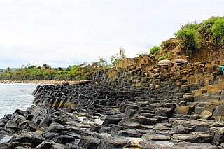
Gành Đá Đĩa or Ghềnh Đá Đĩa is a seashore area of uniformly interlocking basalt rock columns located along the coast in An Ninh Dong Commune, Tuy An District, Phu Yen Province, Vietnam.

References

  1. Udinmwen, E; Oden, M.I; Ukwang, E.E; Edu, E.S (2016). "Structural Geometry of Ikom Columnar Basalt in the Ikom – Mamfe Basin, Southeastern Nigeria". www.aiscience.org. Retrieved 2022-06-03.
  2. Ntekim, E. E. & Adekeye, J. I. D. (2003). "Petrography and geochemistry of basaltic rocks from the northcentral part of Yola Basin, N.E. Nigeria" (PDF). Nigerian Journal of Pure and Applied Science. 18: 1430–1437. Archived from the original (PDF) on 2016-02-25. Retrieved 2016-02-18.
  3. Grunert, Nicole (2000). Namibia: Fascination of Geology – A Travel Handbook. Windhoek: Klaus Hess. pp. 73–74. ISBN   99916-747-8-0.
  4. Columnar Basaltic Lava, Coconut Island (St. Mary's Islands), Udupi District, Karnataka, Geological Survey of India.
  5. "Rare rock formation found in Dewas". The Times of India. 24 December 2012. Retrieved 28 August 2019.
  6. Rare basalt columns found in village in Kolhapur, Business Line, 6 Sept 2018.
  7. 1 2 3 4 Telangana: 6.5 crore-year-old basalt columns discovered in Adilabad forest, Times of India, 9 Aug 2021.
  8. Columnar basalt formations found in Asifabad forests in Telangana, Indian Express, 6 June 2022.
  9. Po, Kimberly (27 April 2014). "H E L L O ♥ K I M M Y : Dunsulan Falls Of Bataan". Hellowkimmy.blogspot.com.
  10. "Bataan Day Trip: Mount Samat and Dunsulan Falls Itinerary". Janegalvez.com. 27 February 2016.
  11. "Bulingan Falls". ChoosePhilippines.com. 28 August 2013. Retrieved 31 July 2018.
  12. "Мыс Столбчатый". www.webpark.ru. Archived from the original on 2019-04-06. Retrieved 2013-09-28.
  13. ม่อนเสาหินพิศวง Wonderful Mountain Of Colunnar Archived 2012-07-17 at archive.today
  14. Kölbl-Ebert, Martina; Colicchio, Stéphanie (2014). "The Boyabat Basalt Cliffs" (PDF). l'association de la Maison de la Géologie et de l'Environnement de Haute-Alsace. Retrieved 29 January 2017.
  15. "Panská skála". Luzicke-hory.cz. Retrieved 26 December 2018.
  16. "PSt04 - Pico de Ana Ferreira". geodiversidade.madeira.gov.pt.
  17. Gobierno vasco. "Basaltos de Fruiz" (PDF). Inventario lugares de interés geológico en la comunidad autónoma del País Vasco (in Spanish). Retrieved 18 February 2016.
  18. La Gomera: basalt cliffs Los Organos, Commons.wikimedia.org
  19. Hazelhurst, S Rennie (22 November 2012). Northumberland. Cambridge University Press. ISBN   9781107677500 . Retrieved 5 August 2022.
  20. "Jaw-dropping geology from Strumble Head to Cardigan". National Trust. Retrieved 3 August 2022.
  21. Scott, Chris (31 October 2017). "The Grand Canyon of the Arctic Circle". CNN Travel. video by Effie Nidam, Diana Diroy and Chris Scott.
  22. "México Travel Club". www.mexicotravelclub.com. Retrieved July 15, 2020.
  23. Callan Bentley (14 November 2011). "Compton Peak: superb columnar jointing". Mountain Beltway. American Geophysical Union (Blog). Retrieved 24 July 2015.
  24. "Greenstone lava flows - National Park Service, Shenandoah National Park, Learn About the Park". NPS.gov. 26 February 2015. Retrieved 3 July 2022.
  25. "GeoSights: Paul Bunyan's Woodpile, Juab County – Utah Geological Survey". geology.utah.gov. Retrieved 2018-09-07.
  26. Geology of the New York City Regions
  27. File:Columnar basalt.jpg (Wikimedia Commons)
  28. "Merriwa NSW Free Rest Areas". highwaytraveller.com.au.
  29. "Sawn Rocks, Mount Kaputar National Park" (PDF). NSW National Parks and Wildlife Service. Retrieved 19 February 2016.
  30. Mount Scoria culture
  31. Ruined Castle - Panoramio
  32. "Bunbury Basalt". Western Australian Museum . Retrieved 6 March 2021.
  33. 1 2 "Black Head : Vegetation Condition After Quarrying" (PDF). Doc.govt.nz. Retrieved 26 December 2018.
  34. "Basalt columns". chathamislands.co.nz. Tourism Chatham Islands. Retrieved 11 February 2024.
  35. "New Zealand Tramper - A community for good, keen trampers and hikers". Tramper.nz. Retrieved 26 December 2018.
  36. The Pinnacles, Mt Somers on flickr
  37. "Mars and Earth: Columnar Jointing". Earthobservatory.nasa.gov. 10 June 2009.