Yola, meaning 'Great Plain' or 'Vast Plain Land', is a large city, capital city and administrative centre of Adamawa State, Nigeria. It is located on the Benue River, and it has a population of over 336,648 (2010). Yola is split into two parts. The old town of Yola where the Lamido resides is the traditional city and the new city of Jimeta is the administrative and commercial centre. They are generally referred to as Yola.

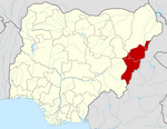
Adamawa state is a state in the North-East geopolitical zone of Nigeria, bordered by Borno to the northwest, Gombe to the west for 95 km, and Taraba to the southwest for about 366 km, while its eastern border forms part of the national border with Cameroon across the Atlantica Mountains for about 712 km. It takes its name from the historic emirate of Adamawa, with the emirate's old capital of Yola, serving as the capital city of Adamawa state. The state is one of the most heterogeneous in Nigeria, with over 100 indigenous ethnic groups. It was formed in 1991, when the former Gongola state was divided into Adamawa and Taraba states. Since it was carved out of the old Gongola State in 1991 by the General Ibrahim Badamsi Babangida military regime, Adamawa State has had 10 men, both military and civilian, controlling the levers of power, who played crucial roles in transforming the state into what it is today.

Benue River, previously known as the Chadda River or Tchadda, is the major tributary of the Niger River, with a length of approximately 1,400 kilometres (870 mi) long and almost entirely navigable during the summer months. The size of its catchment basin is 319,000 km2 (123,000 sq mi). As a result, it is an important transportation route in the regions through which it flows. The name Benue comes from Binuwe meaning 'Mother of Waters’ in the Batta language.

Nasarawa State is a state in the North Central region of Nigeria, bordered to the east by the states of Taraba and Plateau, to the north by Kaduna State, to the south by the states of Benue and Kogi, and to the west by the Federal Capital Territory. Named for the historic Nasarawa Emirate, the state was formed from the west of Plateau State on 1 October 1996. The state has thirteen local government areas and its capital is Lafia, located in the east of the state, while a key economic centre of the state is the Karu Urban Area—suburbs of Abuja—along the western border with the FCT.
Song is a town and Local Government Area in Adamawa State, Nigeria is a town and also a local government area in the state with the area council consisting districts of Song, Dumme, Dirma, Kilange, Funa, Gudu, Mboi, Kilange, Hirna, Gari, Waje, Suktu, Zumo, Waltandi and Ditera.

Gboko is a Local Government Area in Benue state, North-central Nigeria. It is headquartered in the town of Gboko.

Madagali or Madagli is a town and local government area in Adamawa State, Nigeria, adjacent to the border with Cameroon.
Demsa is a Local Government Area of Adamawa State, Nigeria with headquarters located in Demsa. Demsa lies on the Benue River.
Fufore Local Government Area of Adamawa State, Nigeria.

Girei is a town and local government area of Adamawa State, Nigeria. It lies on the Benue River. The dominant tribe in the area are the Fulɓe or Fulani; however, a substantial number of Bwatiye also dwell in villages such as Greng, Notable, and Labondo within the Girei local government area. The primary occupation of the people in the area is farming and cattle rearing. Girei is also a home to Radio Gotel.
Lamurde is a town and Local Government Area of Adamawa State, Nigeria inhabited predominantly by the Bwatiye (Bachama) people.
Maiha is a town and Local Government Area of Adamawa State, Nigeria, adjacent to the border with Cameroon.

Mubi South is a Local Government Area of Adamawa State, Nigeria.
Shelleng is a Local Government Area (LGA) of Adamawa State, North-east Nigeria.
Guma is a Local Government Area of Benue State, North Central Nigeria. Its headquarters are in the town of Gbajimba.
Nafada is one of the eleven Local Government Areas (LGA) of Gombe State, Nigeria. Its headquarter is in the town of Nafada in the east of the area at 11°05′44″N11°19′58″E, on the Gongola River which traverses the area. According to the 2006 census, the LGA covers 1,586 square kilometers and has a population of 138,185 people. Nafada has ten wards namely: Nafada East, Nafada Central, Nafada West, Jigawa, Birnin Fulani East, Birnin Bolewa, Birnin Fulani West, Gudukku, Barwo/Nasarawo and Barwo Winde.
Lau is a Local Government Area in Taraba State, Nigeria. Its headquarters is in the town of Lau and the area is dominated by Hausa Fulani people. Lau Local government has a border with Ardo Kola, Jalingo, Yorro and Zing local governments of Taraba state. It also shares a border with Numan, Adamawa State.
Adamawa State Polytechnic is a tertiary educational institution in Yola, Adamawa State, Nigeria. It was established in 1991 through a merger of the College of Preliminary Studies Yola and the Staff Development Institute, Numan. The new polytechnic provides national diploma programs in computer science, statistics, accountancy, business studies and secretarial studies. The polytechnic, run by the State government, is accredited by the National Board for Technical Education. The institution has become affiliated with the University of Maiduguri for the purpose of running degree programmes.
The Bwatiye people refer to the Bachama and Bata which are a set of people that can be found in Numan, Demsa,Girie,Fufore and Lamurde Local Governments of Adamawa State and in some part of the Cameroons Republic.
Daniel Shaga Ismaila is the 29th paramount ruler of the Bwatiye people as approved by the Governor of Adamawa State Ahmadu Umaru Fintiri on 29 July 2020. He is a certified accountant and former Assistant Commander-General of Narcotics (ACGN) of the National Drug Law Enforcement Agency.
Gen. Muhammad Almustapha Musa @ New Motor Park, Numan Nigeria (11 April 2021).