Shelleng

Last updated

Shelleng
LGA and town
Nigeria location map.svg
Red pog.svg
Shelleng
Coordinates: 9°53′5″N12°0′32″E / 9.88472°N 12.00889°E / 9.88472; 12.00889
CountryFlag of Nigeria.svg  Nigeria
State Adamawa State
Area
  Total533 sq mi (1,381 km2)
Population
 (2022) [1]
  Total229,000
  Density430/sq mi (170/km2)
Time zone UTC+1 (WAT)
Shelleng

Shelleng is a Local Government Area (LGA) of Adamawa State, North-east Nigeria. [2]

Contents

The LGA shares borders with Guyuk and Girei LGA and is made up of towns and villages such as Kiri, Bodwai, Gundo, Jumbul, Shelleng, Timbu, Ketembere, Dunge, Boburo, and Tallum. Shelleng Local government has an estimated population of 190,671 inhabitants with the area consisting members of varying ethnic group such as the Fulani, Lala, Kana Kuri, Kiri, and the Bura. The Bura language is one of the spoken languages in Shelleng LGA while the religions of Christianity and Islam are commonly practiced in the area. Popular festivals celebrated in Shelleng LGA include the Mendamo festival while the landmarks in the area include the Kiri Dam and the Shelleng Cottage Hospital. [3] [4] [5]

Geography

Shelleng local government covers a total area of 1,359 square kilometres and has an average temperature of 32 °C. It lies along the Lake Chad Basin and has the Kiri and Gongola River flowing through its territory. [3]

Economy

Fishing, farming, trading of livestocks and animal rearing are economic activities with domestic animals such as cows, goats, rams, and horses reared and sold in large quantities within the area. The LGA is also home to a vibrant trade sector, hosting several markets such as kasuwan jun ma’a (friday market) and kasuwan kiri (kiri market) where a wide variety of commodities are bought and sold. Other economic activities undertaken by the people of Shelleng LGA include hunting, pottery and crafts making. The Kiri Dam is used for supplying water for agriculture in the area and aides fishing. [3]

Climate

The rainy season in Shelleng is hot, humid, and cloudy, whereas the dry season is hot and partially cloudy. Throughout the year, the temperature ranges from 62 °F to 103 °F, with temperatures rarely falling below 57 °F or rising over 108 °F. [6] [7]

From February 24 to April 24, which is the start of the hot season, there are two months with daily highs that are above 100°F on average. With an average high temperature of 101°F and low temperature of 80°F, April is the hottest month of the year in Shelleng. [8] [9]

From June 22 to October 5, the cool season, which has an average daily high temperature below 90°F, lasts for 3.5 months. With an average low of 63°F and high of 92°F, December is the coldest month of the year in Shelleng. [10] [11]

Related Research Articles

<span class="mw-page-title-main">Ningi, Nigeria</span> Place in Bauchi State, Nigeria

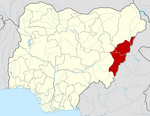
Ningi is a town, a local government area, and an emirate in Bauchi State, Nigeria. The Ningi emirate comprises two local government areas, Ningi and Warji, with a combined area of 5,250 km2 and a population of 501,912 according to the 2006 Census. The Ningi local government area covers an area of 4,625 km2 with a population of 387,192 at the 2006 Census. The area is inhabited mostly by hausa people, Duwa, Ningawa.Yunusa Muhammadu Danyaya is the current Emir of Ningi.

Song is a town and Local Government Area in Adamawa State, Nigeria is a town and also a local government area in the state with the area council consisting districts of Song, Dumme, Dirma, Kilange, Funa, Gudu, Mboi, Kilange, Hirna, Gari, Waje, Suktu, Zumo, Waltandi and Ditera.

Bakori is a local government area in Katsina State, Nigeria. It was created on 15 May 1989 by the then military governor of Katsina State Major General Lawrence Onoja

Oye is a town and headquarter of Oye Local Government Area in Ekiti State, Nigeria. Oye Local Government Area was carved out from the defunct Ekiti North Local Government on 17 May 1989.

Emure is a town in the Ekiti State of Nigeria. It is also called Emure Ekiti. It became much better known in the US after the king of Emure's grandson Adewale Ogunleye made it into the NFL for the Chicago Bears.

<span class="mw-page-title-main">Madagali</span> LGA and town in Adamawa State, Nigeria

Madagali or Madagli is a town and local government area in Adamawa State, Nigeria, adjacent to the border with Cameroon.

Demsa is a Local Government Area of Adamawa State, Nigeria with headquarters located in Demsa. Demsa lies on the Benue River.

<span class="mw-page-title-main">Fufore</span> LGA in Adamawa State, Nigeria

Fufore Local Government Area of Adamawa State, Nigeria.

<span class="mw-page-title-main">Ganye</span> LGA and town in Adamawa State, Nigeria

Ganye is a town and Local Government Area of Adamawa State, Nigeria. Jada and Toungo Local Governments were carved out from Ganye local government area of Adamawa state Nigeria. Ganye is bordered by Jada Local Government Area to the North and East, Toungo Local Government Area to the South and Taraba State to the West. It is the headquarter of the Sama (Chamba) people worldwide.

<span class="mw-page-title-main">Girei</span> LGA and town in Adamawa State, Nigeria

Girei is a town and local government area of Adamawa State, Nigeria. It lies on the Benue River. The dominant tribe in the area are the Fulɓe or Fulani; however, a substantial number of Bwatiye also dwell in villages such as Greng, Notable, and Labondo within the Girei local government area. The primary occupation of the people in the area is farming and cattle rearing. Girei is also a home to Radio Gotel.

<span class="mw-page-title-main">Jada, Nigeria</span> LGA and town in Adamawa State, Nigeria

Jada is a town and Local Government Area of Adamawa State, Nigeria.

Lamurde is a town and Local Government Area of Adamawa State, Nigeria inhabited predominantly by the Bwatiye (Bachama) people.

Maiha is a town and Local Government Area of Adamawa State, Nigeria, adjacent to the border with Cameroon.

<span class="mw-page-title-main">Mubi South</span> LGA in Adamawa State, Nigeria

Mubi South is a Local Government Area of Adamawa State, Nigeria.

Numan, also known as Nomweh, is a town and a Local Government Area in Adamawa State, Nigeria. It is a port town that lies on the confluence of Benue River and Gongola River.

Kwaya Kusar is a Local Government Area of Borno State, Nigeria. Its headquarters are in the town of Kwaya Kusar.

Ise/Orun is a Local Government Area of Ekiti State, Nigeria. Its headquarters are in the town of Ise Ekiti.

Nafada is one of the eleven Local Government Areas (LGA) of Gombe State, Nigeria. Its headquarter is in the town of Nafada in the east of the area at 11°05′44″N11°19′58″E, on the Gongola River which traverses the area. According to the 2006 census, the LGA covers 1,586 square kilometers and has a population of 138,185 people. Nafada has ten wards namely: Nafada East, Nafada Central, Nafada West, Jigawa, Birnin Fulani East, Birnin Bolewa, Birnin Fulani West, Gudukku, Barwo/Nasarawo and Barwo Winde.

Birnin Gwari is a Local Government Area in Kaduna State, Nigeria. Its headquarters are in the town of Birnin Gwari.

Birnin Magaji/Kiyaw is a Local Government Area in Zamfara State, Nigeria. Its headquarters are in the town of Birnin Magaji in the north of the LGA at12°33′00″N6°49′00″E. The LGA is also named from the town of Kiyaw to the south.

References

  1. "Shelleng (Local Government Area, Nigeria) - Population Statistics, Charts, Map and Location". www.citypopulation.de. Retrieved 2024-02-05.
  2. "Shelleng, Nigeria - Facts and information on Shelleng - Nigeria.Places-in-the-world.com". nigeria.places-in-the-world.com. Retrieved 2023-08-06.
  3. 1 2 3 "Shelleng Local Government Area". www.manpower.com.ng. Retrieved 2023-08-06.
  4. "Shelleng Local Government Area". www.finelib.com. Retrieved 2023-08-06.
  5. "Information about Shelleng | Nigeria Facts". nigeriafacts.net. Retrieved 2023-08-06.
  6. "Shelleng Climate, Weather By Month, Average Temperature (Nigeria) - Weather Spark". weatherspark.com. Retrieved 2023-07-14.
  7. "Mubi Climate, Weather By Month, Average Temperature (Nigeria) - Weather Spark". weatherspark.com. Retrieved 2023-07-14.
  8. "Shelleng Climate, Weather By Month, Average Temperature (Nigeria) - Weather Spark". weatherspark.com. Retrieved 2023-08-06.
  9. "Weather in Shelleng today". GISMETEO.COM. Retrieved 2023-08-06.
  10. "Shelleng March Weather, Average Temperature (Nigeria) - Weather Spark". weatherspark.com. Retrieved 2023-08-06.
  11. "Observed historical climate & weather data for Shelleng". meteoblue. Retrieved 2023-08-06.