Mubi South | |
|---|---|
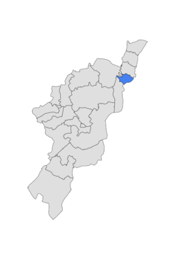 Map of Adamawa State highlighting Mubi South | |
| Country | |
| State | Adamawa State |
| Time zone | UTC+1 (WAT) |
 | |
Mubi South is a Local Government Area of Adamawa State, Nigeria.
Mubi South | |
|---|---|
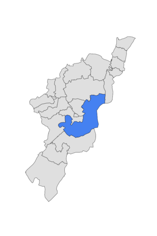
| Map of Adamawa State highlighting Mubi South | |
| Country | |
| State | Adamawa State |
| Time zone | UTC+1 (WAT) |
| | |
Mubi South is a Local Government Area of Adamawa State, Nigeria.
The Mubi North LGA's economy heavily relies on trade, and the region is home to a number of marketplaces, including the well-known Mubi cattle market where a variety of domestic animals are purchased and sold. With a variety of crops being grown in the LGA, farming is another important aspect of the Mubi North economy. Hunting, animal husbandry, and craft-making are some of the residents of Mubi North LGA's other significant occupations. [1]
The rainy season in Mubi south is unpleasant and overcast, the dry season is partly cloudy, and it is hot all year. Throughout the year, the temperature normally ranges from 60 °F to 101 °F, with temperatures rarely falling below 55 °F or rising over 107 °F. [2] [3]
With an average daily high temperature of 98°F, the hot season lasts for 2.1 months, from March 4 to May 7. With an average high of 100°F and low of 78°F, April is the warmest month of the year in Mubi. [4]
With an average daily maximum temperature below 87°F, the cool season lasts for 3.0 months, from June 29 to September 30. In Mubi, January is the coldest month of the year, with an average low of 61°F and high of 88°F. [5]

Ningi is a town, a local government area, and an emirate in Bauchi State, Nigeria. The Ningi emirate comprises two local government areas, Ningi and Warji, with a combined area of 5,250 km2 and a population of 501,912 according to the 2006 Census. The Ningi local government area covers an area of 4,625 km2 with a population of 387,192 at the 2006 Census. The area is inhabited mostly by hausa people, Duwa, Ningawa.Yunusa Muhammadu Danyaya is the current Emir of Ningi.

Gboko is a Local Government Area in Benue state, North-central Nigeria. It is headquartered in the town of Gboko.
Ikere-Ekiti, also known as Ikere or Ikerre, is a city in Ekiti State of Nigeria. It is an agricultural and mine centre. According to the 1963 and 1991 census, the population was 114,780 and 60,257 respectively, but the 2006 census recorded it to be 147,355.
Agaie is a Local Government Area in Niger State, Nigeria. Its headquarters are in the town of Agaie on the A124 highway.
Oye is a town and headquarter of Oye Local Government Area in Ekiti State, Nigeria. Oye Local Government Area was carved out from the defunct Ekiti North Local Government on 17 May 1989.
Demsa is a Local Government Area of Adamawa State, Nigeria with headquarters located in Demsa. Demsa lies on the Benue River.
Fufore Local Government Area of Adamawa State, Nigeria.

Ganye is a town and Local Government Area of Adamawa State, Nigeria. Jada and Toungo Local Governments were carved out from Ganye local government area of Adamawa state Nigeria. Ganye is bordered by Jada Local Government Area to the North and East, Toungo Local Government Area to the South and Taraba State to the West. It is the headquarter of the Sama (Chamba) people worldwide.
Gombi is the Local Government Headquarter of Gombi Local Government Area of Adamawa State, Nigeria.
Maiha is a town and Local Government Area of Adamawa State, Nigeria, adjacent to the border with Cameroon.

Mubi North is a Local Government Area of Adamawa State, Nigeria. The town is the location of the Adamawa State University and the Federal Polytechnic, Mubi.
Numan, also known as Nomweh, is a town and a Local Government Area in Adamawa State, Nigeria. It is a port town that lies on the confluence of Benue River and Gongola River.
Shelleng is a Local Government Area (LGA) of Adamawa State, North-east Nigeria.
Alkaleri is a Local Government Area of Bauchi State, Nigeria. Its headquarters are in the town of Alkaleri on the A345 highway in the north of the area at10°15′58″N10°20′07″E.The northeasterly line of equal latitude and longitude passes through the Local Government Area.
Ise/Orun is a Local Government Area of Ekiti State, Nigeria. Its headquarters are in the town of Ise Ekiti.
Augie is a Local Government Area in Kebbi State, Nigeria. Its headquarters are in the town of Augie.

Keffi Local Government Area and also is a traditional or commercial town in Nasarawa north central Nigeria Its headquarters are in the town of Keffi. Keffi is 50 kilometers from Abuja. Nasarawa State university is located in Keffi sitting along Keffi-Akwanga express way.
Machina is a Local Government Area in Yobe State, Nigeria. Its headquarters are in the town of Machina at 13°08′11″N10°02′57″E. It shares a border in the north with The Republic of Niger.
Jakusko is a Local Government Area in Yobe State, Nigeria. Its headquarters are in the town of Jakusko in the west of the area at 12°22′09″N10°46′23″E.
Fika is a Local Government Area in Yobe State, Nigeria. Its headquarters are in the town of Fika in the south of the area at 11°17′00″N11°18′29″E.
State capital: Yola | ||
| Local Government Areas | 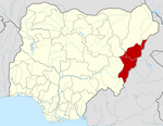 | |
| | This Adamawa state location article is a stub. You can help Wikipedia by expanding it. |