Mubi North

Last updated

Mubi North
LGA
Mubi North.png
Map of Adamawa State highlighting Mubi North
Nigeria location map.svg
Red pog.svg
Mubi North
Coordinates: 10°16′N13°16′E / 10.267°N 13.267°E / 10.267; 13.267
CountryFlag of Nigeria.svg  Nigeria
State Adamawa State
Capital Mubi
Time zone UTC+1 (WAT)
Mubi North

Mubi North is a Local Government Area of Adamawa State, Nigeria. The town is the location of the Adamawa State University and the Federal Polytechnic, Mubi. [1]

Contents

Climate

The rainy season in Mubi is oppressive and overcast, the dry season is partly cloudy, and it is hot all year. Throughout the year, the temperature normally ranges from 60 °F to 101 °F, with temperatures rarely falling below 55 °F or rising over 107 °F. [2] [3]

Mubi North's Temperature

From March 4 to May 7, the hot season, with an average daily high temperature above 98 °F, lasts for 2.1 months. In Mubi, April is the hottest month of the year, with an average high of 100 °F and low of 78 °F. [4] [5]

Mubi North's Cool Temperature

From June 29 to September 30 there is a 3.0 month cool season with an average daily high temperature of less than 87 °F. With an average low of 61 °F and high of 88 °F, January is the coldest month of the year in Mubi. [6] [7]

Mubi North's Clouds

The average proportion of sky that is covered by clouds in Mubi varies significantly seasonally throughout the year. [8] [9]

Around October 23 marks the start of Mubi's clearer season, which lasts for 4.5 months and ends around March 9. [10] [11]

In Mubi, January is the clearest month of the year, with the sky remaining clear, mostly clear, or partly overcast 56% of the time. [12] [13]

Beginning around March 9 and lasting about 7.5 months, the cloudier period of the year ends around October 23. [14] [15]

May is the cloudiest month of the year in Mubi, with the sky being overcast or mostly cloudy 76% of the time on average during this month. [16] [17]

Mubi North's Precipitation

A day is considered to be wet if there has been at least 0.04 inches of liquid or liquid-equivalent precipitation. Throughout the year, there are huge variations in the likelihood of rainy days in Mubi. [18] [19]

In the 4.5-month-long wetter season, which runs from May 18 to October 4, there is a greater than 43% chance that any given day would be rainy. With an average of 26.3 days with at least 0.04 inches of precipitation, August is the month with the most rainy days in Mubi. [20]

From October 4 to May 18, the dry season lasts 7.5 months. With an average of 0.0 days with at least 0.04 inches of precipitation, January is the month with the fewest wet days in Mubi. [21] [22]

We categorize wet days into those that include snow, rain, or a combination of the three. In Mubi, August has an average of 26.3 days of rain, which is the most of any month. This classification shows that rain alone is the most frequent type of precipitation throughout the year, with a high likelihood of 87% on August 18. [23]

Related Research Articles

Yola, meaning 'Great Plain' or 'Vast Plain Land', is a large city, capital city and administrative centre of Adamawa State, Nigeria. It is located on the Benue River, and it has a population of over 336,648 (2010). Yola is split into two parts. The old town of Yola where the Lamido resides is the traditional city and the new city of Jimeta is the administrative and commercial centre. They are generally referred to as Yola.

Yenagoa is a Local Government Area and capital city of Bayelsa State, southern Nigeria. It is located at the southern part of the country at coordinates 4°55′29″N6°15′51″E.

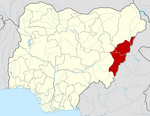
Ogoja is a Local Government Area in Cross River State, Nigeria. Its headquarters is Ogoja town in the northeast of the area near the A4 highway at 6°39′17″N8°47′51″E.

Bende is a Local Government Area in Abia State, Nigeria with headquarters located in Bende Community. Bende Local Government Area (L.G.A) of Abia state lies on 70 30I of the Greenwich Meridian and latitude 50 30I North of the Equator. It is composed of thirteen (13) communities, namely: Alayi, Bende, Ezukwu, Igbere, Item, Itumbuzo, Nkpa, Ntalakwu, Ozuitem, Ugwueke, Umu-imenyi, Umuhu-Ezechi, and Uzuakoli.

Ankpa is a Local Government Area in Kogi State, Nigeria. Its headquarters are in the town of Ankpa on the A233 highway in the west of the area at7°22′14″N7°37′31″E.

Demsa is a Local Government Area of Adamawa State, Nigeria with headquarters located in Demsa. Demsa lies on the Benue River.

<span class="mw-page-title-main">Ganye</span> LGA and town in Adamawa State, Nigeria

Ganye is a town and Local Government Area of Adamawa State, Nigeria. Jada and Toungo Local Governments were carved out from Ganye local government area of Adamawa state Nigeria. Ganye is bordered by Jada Local Government Area to the North and East, Toungo Local Government Area to the South and Taraba State to the West. It is the headquarter of the Sama (Chamba) people worldwide.

Gombi is the Local Government Headquarter of Gombi Local Government Area of Adamawa State, Nigeria.

<span class="mw-page-title-main">Jada, Nigeria</span> LGA and town in Adamawa State, Nigeria

Jada is a town and Local Government Area of Adamawa State, Nigeria.

Maiha is a town and Local Government Area of Adamawa State, Nigeria, adjacent to the border with Cameroon.

<span class="mw-page-title-main">Mubi South</span> LGA in Adamawa State, Nigeria

Mubi South is a Local Government Area of Adamawa State, Nigeria.

Mayo-Belwa, is a Local Government Area in Adamawa State, Nigeria. It had an estimated population of about 204,200 people as of 2016. It shares boundary with Taraba State to the west.

Akko is a local government area of Gombe, Gombe State, Nigeria. Its headquarters is in Kumo town on the A345 highway south of the state capital Gombe, about 40 km away. Kumo (headquarter) is a cosmopolitan communities of more than 30 differents tribes, ranging from the dominant Fulani tribe to Tangale, Tera, Hausa and other minorities.

Ife South is a Local Government Area in Osun State, Nigeria. Its headquarters are in the town of Ifetedo at 7°11′00″N4°42′00″E.

Ede North is a Local Government Area in Osun State, Nigeria. Its headquarters as Abere.

Akwete town is the headquarters of Ukwa East local government area of Abia state, Nigeria. Akwete is located 18 Kilometers northeast of the oil-rich city of Port Harcourt and 18 Kilometers southeast of the commercial city of Aba. Akwete is an important community of the Ndoki and Igbo people in general, they belong to the Umuihueze II clan. Akwete is known in West Africa for its unique weaving.

Osu is a town in Osun State, Nigeria.

Okpuala Ngwa is a town in Isiala-Ngwa North. It serves as the administrative headquarters for the local government. It was the first settlement and headquarters of the Ngwa people. The people of Okpuala Ngwa speak the Ngwa dialect of the Ngwa people.

Iperindo town is situated in the Osun region. Osogbo (Osogbo), the capital of Osun, lies about 42 kilometers from Iperindo. Iperindo and Abuja, the capital of Nigeria, are separated by a distance of roughly 341 kilometers.

Bode Osi is a town in Osun State, Nigeria. It is located around 36 kilometres (22 mi) away from Osogbo, the capital of Osun State, and 370 kilometres (230 mi) from Abuja, the capital of Nigeria. Bode Osi is also the headquarters of Ola Oluwa Local Government Area.

References

  1. "Mubi North Local Government Area". www.manpower.com.ng. Retrieved 2023-07-22.
  2. "Mubi Climate, Weather By Month, Average Temperature (Nigeria) - Weather Spark". weatherspark.com. Retrieved 2023-07-13.
  3. "Mubi, Adamawa, NG Climate Zone, Monthly Averages, Historical Weather Data". tcktcktck.org. Retrieved 2023-07-21.
  4. "Mubi North, Nigeria Hourly Weather Forecast | Weather Underground". www.wunderground.com. Retrieved 2023-07-21.
  5. "Mubi North, Nigeria Hourly Weather Forecast | Weather Underground". www.wunderground.com. Retrieved 2023-07-21.
  6. "Simulated historical climate & weather data for Mubi". meteoblue. Retrieved 2023-07-21.
  7. https://www.accuweather.com/en/ng/mubi/251723/current-weather/251723
  8. https://www.accuweather.com/en/ng/mubi/251723/weather-forecast/251723
  9. "Mubi North, Adamawa, NigeriaWeather Forecast and Conditions - The Weather Channel | Weather.com". The Weather Channel. Retrieved 2023-07-21.
  10. "Weather in Mubi - accurate and detailed weather forecast in Mubi for today, tomorrow and week. Mubi, Adamawa, Nigeria". meteotrend.com. Retrieved 2023-07-21.
  11. "Long term weather forecast for Mubi". Yr. 2023-07-22. Retrieved 2023-07-21.
  12. "Mubi Weather". WorldWeatherOnline.com. Retrieved 2023-07-21.
  13. Atlas, Weather. "Mubi, Nigeria - Yearly & Monthly weather forecast". Weather Atlas. Retrieved 2023-07-21.
  14. "Mubi, Nigeria Weather Forecast". www.weather-forecast.com. Retrieved 2023-07-21.
  15. "Mubi North : climate, Mubi North's Hot Temperature Wikipedia, the free encyclopedia » Wiki". en.uk.edu.vn. Retrieved 2023-07-21.
  16. Vizzuality. "Mubi North, Adamawa, Nigeria Deforestation Rates & Statistics | GFW". www.globalforestwatch.org. Retrieved 2023-07-21.
  17. https://www.myweather2.com/City-Town/Nigeria/Mubi/climate-profile.aspx
  18. https://www.researchgate.net/figure/Summary-Analysis-of-Climatic-Data_tbl1_289825832
  19. https://www.researchgate.net/publication/289825832_CLIMATE_CHANGE_IN_ADAMAWA_STATE_NIGERIA_EVIDENCE_FROM_AGRO_CLIMATIC_PARAMETERS
  20. "Mubi North weather forecast for today". justweather.org. Retrieved 2023-07-21.
  21. "Travel Weather Averages (Weatherbase)". Weatherbase. Retrieved 2023-07-21.
  22. "climate of Mubi North - Google Search". www.google.com. Retrieved 2023-07-21.
  23. Aide, Michael T.; Braden, Indi (2022-12-14). Soil Science: Emerging Technologies, Global Perspectives and Applications. BoD – Books on Demand. ISBN   978-1-83969-520-9.