List of populated places in the Caribbean

Last updated
The Caribbean region Caribbean general map.png
The Caribbean region

This is a list of populated places in the Caribbean.p Only the major metropolitan areas and largest populated or significant places in each country, national region/district, or national territory are listed. In most cases, the largest populated place for a given country, national region, or territory is the capital city.

Contents

Largest populated places

List of largest populated places by country/region/territory in the Caribbean
Link to list of cities by country, region, or territoryPopulated placePopulationYearRefs
Anguilla (British Overseas Territory) The Valley 2,0352010 [1]
Antigua and Barbuda (Commonwealth realm) Saint John's 24,2262010 [2]
Aruba (Constituent state of the Kingdom of the Netherlands) Oranjestad 29,9982010 [3]
Bahamas (Commonwealth Realm) Nassau 227,9402010 [4]
Barbados Bridgetown 98,5112010 [5]
Belize (Commonwealth Realm) Belize City [Note 1] 61,4612010 [6]
Bonaire (special municipality of the Netherlands) Kralendijk 10,6202017 [7]
British Virgin Islands (British Overseas Territory) Road Town 8,4492010 [8]
Cayman Islands (British Overseas Territory) George Town [Note 2] 40,2002019 [9] [10]
Cuba Havana 2,117,6252015 [11]
Curaçao (Constituent state of the Kingdom of the Netherlands) Willemstad 136,6602011 [12]
Dominica Roseau 14,7252011 [13]
Dominican Republic Santo Domingo 3,658,6482015 [14]
Grenada (Commonwealth Realm) St. George's 33,7342012 [15]
Guadeloupe (overseas department/region and single territorial collectivity of France) Pointe-à-Pitre 132,8842013 [16]
Haiti Port-au-Prince 2,618,8942015 [17]
Jamaica (Commonwealth Realm) Kingston 1,190,7632015 [18] [19]
Martinique (overseas department/region and single territorial collectivity of France) Fort-de-France 78,1262013 [20]
Montserrat (British Overseas Territory) Brades 1,0001998 [21]
Nueva Esparta (a Venezuelan state) Porlamar [Note 1] 144,8302011 [22]
Puerto Rico (Territory of the United States) San Juan metropolitan area 2,196,5382015 [23]
Saba (special municipality of the Netherlands) The Bottom 4622001 [24]
San Andrés and Providencia (Colombian department) San Andrés [Note 1] 55,4262005 [25]
Saint Barthélemy (Dependent Territory of France) Gustavia 2,3002017 [26]
Saint Kitts and Nevis (Commonwealth Realm) Basseterre 14,0002018 [27]
Saint Lucia (Commonwealth Realm) Castries 20,0002010 [28]
Saint Martin (Dependent Territory of France) Marigot 5,7002006 [29]
Saint Vincent and the Grenadines (Commonwealth Realm) Kingstown 12,9092012 [30]
Sint Maarten (Constituent state of the Kingdom of the Netherlands) Philipsburg 1,8942017 [31]
Sint Eustatius (special municipality of the Netherlands) Oranjestad 1,0382001 [32]
Trinidad and Tobago Chaguanas [Note 1] 83,4892011 [33]
Turks and Caicos Islands (British Overseas Territory) Providenciales [Note 1] 23,7692012 [34]
United States Virgin Islands (Territory of the United States) Charlotte Amalie 18,4812010 [35] [36]

Notes:

  1. 1 2 3 4 5 Not the capital of the country
  2. George Town is the largest city by population of the British Overseas Territories

Map of places

Largest populated places in Caribbean countries
List of populated places in the Caribbean
Invisible Square.svg
Mapscaleline.svg
1000km
620miles
Red pog.svg
Red pog.svg
The Bottom
Red pog.svg
Brades
Red pog.svg
Oranjestad
Red pog.svg
Philipsburg
Red pog.svg
The Valley
Red pog.svg
Gustavia
Red pog.svg
Marigot
Red pog.svg
Red pog.svg
Red pog.svg
Kingstown
Red pog.svg
Basseterre
Red pog.svg
Roseau
Red pog.svg
Charlotte Amalie
Red pog.svg
Castries
Red pog.svg
Providenciales
Red pog.svg
St. John's
Red pog.svg
Oranjestad
Red pog.svg
St. George's
Red pog.svg
George Town
Red pog.svg
San Andrés
Red pog.svg
Belize City
Red pog.svg
Fort-de-France
Red pog.svg
Chaguanas
Red pog.svg
Red pog.svg
Pointe-à-Pitre
Red pog.svg
Willemstad
Red pog.svg
Porlamar
Red pog.svg
Nassau
Red pog.svg
Kingston
Red pog.svg
Havana
Red pog.svg
San Juan metropolitan area
Red pog.svg
Port-au-Prince
Red pog.svg
Santo Domingo
Caribbean in green.png
Invisible Square.svg
  
Caribbean region, click on Interactive Map to browse region with ordered list of places by population

Cities in other nearby countries

See also

Related Research Articles

<span class="mw-page-title-main">Demographics of the Netherlands</span>

Demographic features of the population of the Netherlands include population density, ethnicity, education level, health of the population, economic status, religious affiliations and other aspects of the population.

<span class="mw-page-title-main">Rozendaal</span> Municipality in Gelderland, Netherlands

Rozendaal is a municipality and a town in the eastern Netherlands, in the province of Gelderland. The town, next to Arnhem and Velp, is known for the Rozendaal Castle and its water fountain follies (bedriegertjes).

<span class="mw-page-title-main">Statistics Netherlands</span> Netherlands principal government institution in charge of statistics and census data

Statistics Netherlands, founded in 1899, is a Dutch governmental institution that gathers statistical information about the Netherlands. In Dutch it is known as the Centraal Bureau voor de Statistiek, often abbreviated to CBS. It is located in The Hague and Heerlen. Since 3 January 2004, Statistics Netherlands has been an independent public body, or quango. Its independent legal status enables the reliable collection and dissemination of information to support public debate, policy development and decision-making.

<span class="mw-page-title-main">Oranjestad, Sint Eustatius</span> Town in Sint Eustatius, Netherlands

Oranjestad is a small town of 1,038 inhabitants; it is the capital and largest town of the island of Sint Eustatius in the Caribbean Netherlands. It’s not to be confused with the far larger Oranjestad in Aruba.

<span class="mw-page-title-main">The Bottom</span> Village in Saba, Dutch Caribbean

The Bottom is the capital and largest town of the island of Saba, the Caribbean Netherlands. It is the first stop on the way from Saba's Port in Fort Bay towards the rest of the island. In 2001, it had 462 inhabitants of the total 1,349 islanders. It is the administrative center of Saba. It is the hometown of ESC Oxyo.

<span class="mw-page-title-main">Windwardside</span> Village in Saba, Dutch Caribbean

Windwardside is the second largest town on the island of Saba, aptly named for being on the windward side of the island.

<span class="mw-page-title-main">Mijdrecht</span> Place in Utrecht, Netherlands

Mijdrecht is a town in the Netherlands with about 16,000 residents. It is located in the municipality of De Ronde Venen, about 7 kilometres (4.3 mi) west of the main A2 motorway, between Utrecht and Amsterdam.

<span class="mw-page-title-main">Largest cities in the Americas</span> List of largest cities located in The Americas

This is a list of the 50 largest cities in the Americas by population residing within city limits as of 2015, the most recent year for which official population census results, estimates, or short-term projections are available for most of these cities. These figures do not reflect the population of the urban agglomeration or metropolitan area which typically do not coincide with the administrative boundaries of the city. For a list of the latter, see List of metropolitan areas in the Americas by population. These figures refer to mid-2015 populations with the following exceptions:

  1. Mexican cities, whose figures derive from the 2015 Intercensal Survey conducted by INEGI with a reference date of 15 March 2015;
  2. Calgary, whose 2015 municipal census had a reference date of April 1.
  3. Brazilian cities, whose figures originate from the 2021 estimate given by the IBGE, with a reference date of July 1, 2021.
<span class="mw-page-title-main">Christianity by country</span>

As of the year 2021, Christianity had approximately 2.4 billion adherents and is the largest religion by population respectively. According to a PEW estimation in 2020, Christians made up to 2.38 billion of the worldwide population of about 8 billion people. It represents nearly one-third of the world's population and is the largest religion in the world, with the three largest groups of Christians being the Catholic Church, Protestantism, and the Eastern Orthodox Church. The largest Christian denomination is the Catholic Church, with 1.3 billion baptized members. The second largest Christian branch is either Protestantism, or the Eastern Orthodox Church.

<span class="mw-page-title-main">Dutch diaspora</span> Ethnic diaspora

The Dutch diaspora consists of the Dutch and their descendants living outside the Netherlands.

<span class="mw-page-title-main">Westmaas</span> Village in South Holland, Netherlands

Westmaas is a village in the Dutch province of South Holland. It is located about 14 km south of the city of Rotterdam, next to Mijnsheerenland in the municipality of Hoeksche Waard. In 2020, the population was 2065.

<span class="mw-page-title-main">Caribbean Netherlands</span> Netherlands Caribbean municipalities

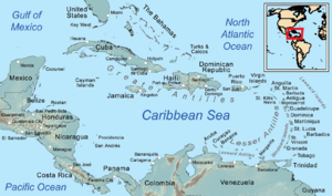
The Caribbean Netherlands is a geographic region of the Netherlands located outside of Europe, in the Caribbean, consisting of three so-called special municipalities. These are the islands of Bonaire, Sint Eustatius and Saba, as they are also known in legislation, or the BES islands for short. The islands are officially classified as public bodies in the Netherlands and as overseas territories of the European Union; as such, European Union law does not automatically apply to them.

Latin American migration to Europe is the diaspora of Latin Americans to the continent of Europe, dating back to the first decades of the Spanish and Portuguese empires in the Americas. Latin Americans in Europe are now a rapidly growing group consisting of immigrants from Argentina, Bolivia, Brazil, Chile, Colombia, Costa Rica, Cuba, Dominican Republic, Ecuador, El Salvador, Guatemala, Honduras, Mexico, Nicaragua, Panama, Paraguay, Peru, Puerto Rico, Uruguay and Venezuela. It may also include individuals from certain French-speaking territories depending on the definition of Latin America used.

Island council elections were held in the Netherlands Antilles on 29 April and 6 May 1983 to elect the members of the island councils of its six island territories. The election was won by the People's Electoral Movement in Aruba, the Bonaire Democratic Party in Bonaire, the New Antilles Movement in Curaçao, the Windward Islands People's Movement in Saba, the Democratic Party Statia in Sint Eustatius, and the Democratic Party in Sint Maarten.

References

  1. "The Valley". GeoNames. Retrieved September 13, 2021.
  2. "St. John's". GeoNames. Retrieved September 13, 2021.
  3. "Oranjestad". GeoNames. Retrieved September 13, 2021.
  4. "Nassau". GeoNames. Retrieved September 13, 2021.
  5. "Bridgetown". GeoNames. Retrieved September 13, 2021.
  6. "Belize City". GeoNames. Retrieved September 13, 2021.
  7. "Bonaire, bevolkingscijfers per buurt". Centraal Bureau voor de Statistiek (in Dutch). 2017. Retrieved 2 May 2021. Sum of Entrejol (Antriol), Nikiboko, Noord Saliña, Playa and Tera Kora
  8. "Road Town". GeoNames. Retrieved September 13, 2021.
  9. World Gazetteer
  10. "About Cayman". Gov.ky. 24 September 2013. Retrieved 5 October 2013.
  11. "3. Población Proyectada al 30 de junio, por edades simples y años simples. AMBOS SEXOS. Período 2015 - 2050" (PDF). Proyecciones de la Población de Cuba 2015 - 2050. Oficina Nacional de Estadísticas. Retrieved 2016-04-24.
  12. "Curaçao". City Population. Retrieved 20 April 2021.
  13. "2011 Population and Housing Census – preliminary results" (PDF). Central Statistical Office (Dominica). Retrieved 24 October 2017.
  14. "Región metropolitana". Población total estimadas y proyectadas por año calendario y sexo, según región y provincia 2000-2030 (Report). Oficina Nacional de Estadística. 2014. Archived from the original on 2016-01-31. Retrieved 2016-04-24.
  15. UK Foreign and Commonwealth Office (28 February 2012). "Grenada Today". UK Foreign and Commonwealth Office. Archived from the original on 8 July 2012. Retrieved 6 August 2012.
  16. INSEE. "Recensement de la population en Guadeloupe - 402 119 habitants au 1er janvier 2013" (in French). Retrieved 21 May 2016.
  17. POPULATION TOTALE, DE 18 ANS ET PLUS MENAGES ET DENSITES ESTIMES EN 2015 (PDF) (Report). Institut Haïtien de Statistique et d’Informatique (IHSI). March 2015. p. 23. Archived from the original (PDF) on 2015-11-06. Retrieved 2015-04-25.
  18. Spatial boundaries of Jamaica (PDF) (Report). Planning Institute of Jamaica. Archived from the original (PDF) on 2017-08-29. Retrieved 2016-06-09.
  19. Demographic Statistics 2015 (PDF) (Report). Statistical Institute of Jamaica. p. 29. Archived from the original (PDF) on 2016-08-08. Retrieved 2016-06-09.
  20. INSEE. "Recensement de la population en Martinique – 385 551 habitants au 1er janvier 2013" (in French). Archived from the original on 3 August 2016. Retrieved 21 May 2016.
  21. Leonard, T. M. (2005). Encyclopedia of the Developing World. Routledge. pp.1083. ISBN   978-1-57958-388-0
  22. "Klimatafel von Porlamar / Insel Margarita / Venezuela" (PDF). Baseline climate means (1961–1990) from stations all over the world (in German). Deutscher Wetterdienst. Retrieved 3 February 2019.
  23. "Annual Estimates of the Resident Population: April 1, 2010 to July 1, 2015". United States Census Bureau, Population Division. March 2016. Archived from the original on 2020-02-13. Retrieved 2016-04-25.
  24. "Geodata 2001, Saba & Sint.Eustatius, Census 2001". Centraal Bureau voor de Statistiek, Netherlands Antilles. 2001. p. 17. Retrieved 3 May 2021.
  25. "Census 2005 - San Andrés" (PDF) (in Spanish). (DANE)
  26. "Populations légales 2017 des départements et collectivités d'outre-mer". INSEE (in French). Government of France . Retrieved 2021-01-29.
  27. "CIA World Factbook – Saint Kitts and Nevis". CIA World Factbook . Retrieved 2019-02-24.
  28. "Saint Lucia". GeoNames. Retrieved August 11, 2021.
  29. "Populations légales 2018 des départements et collectivités d'outre-mer". INSEE (in French). Government of France . Retrieved 2021-01-29.
  30. "2012 POPULATION & HOUSING CENSUS PRELIMINARY REPORT" (PDF). Statistical Office Saint Vincent and the Grenadines. Retrieved 19 May 2021.
  31. "Statistical Yearbook 2017" (PDF). Department of Statistics Sint Maarten. 2017. Archived from the original (PDF) on 2020-10-01. Retrieved 2020-01-08.
  32. "Geodata 2001, Saba & Sint.Eustatius, Census 2001". Centraal Bureau voor de Statistiek, Netherlands Antilles. 2001. Retrieved 3 May 2021. Sum of Oranjestad Noord, Oranjestad Zuid, Concordia and Golden Rock
  33. Table from 2000 Census on Central Statistical Office of Trinidad and Tobago website
  34. "Population 2012 census". Government of Turks and Caicos. Retrieved 15 May 2021.
  35. "Census Bureau Releases Census 2000 Population Counts for the U.S. Virgin Islands". U.S. Census Bureau. July 3, 2001. Archived from the original on November 18, 2001. Retrieved December 6, 2017.
  36. ALDETH LEWIN (Daily News Staff) (August 25, 2011). "Census shows V.I.'s population down 2% - News". Virgin Islands Daily News. Archived from the original on April 12, 2013. Retrieved January 11, 2014.