This article has multiple issues. Please help improve it or discuss these issues on the talk page . (Learn how and when to remove these template messages)
|
This article has multiple issues. Please help improve it or discuss these issues on the talk page . (Learn how and when to remove these template messages)
|
There are multiple types of volcanoes in Mexico. Volcanoes can be of different types such as cinder cone volcanoes, composite volcanoes, shield volcanoes, and lava domes. Each of these variations of volcanoes forms in its own way. Cinder cone volcanoes are the simplest type of volcano. This volcano forms from particles of solidified lava that ejected from a single vent. When the lava is eruptive and blows into the air, it separates into small fragments that solidify and fall around the central vent to form an oval cone at the top of the volcano. “Composite volcanoes or stratovolcanoes, make up some of the world’s most memorable mountains: Mount Rainier, Mount Fuji, and Mount Cotopaxi.” [1] These volcanoes are very steep sided and symmetrical, in a cone shape. They have a conduit system which allows the magma to flow from deep within the Earth’s surface. They have many vents within the volcano which allows the lava to break through the walls, which allows for the volcano to grow up to thousands of meters tall. Composite volcanoes are also known to explode violently, as (for instance) Mount St. Helens did in 1980. [2] Another type of volcano, known as shield volcanoes, are very large and look like shields from above. The lava from within shield volcanoes is very thin, so when it pours out in all directions from the central summit vent, it travels for long distances. These volcanoes filled up slowly over time, with eruptions creating layers on top of layers. Unlike shield volcanoes, lava dome volcanoes are created by small masses of lava that are too thick to flow very far down the slope. They commonly occur within the creators of large composite volcanoes. The dome grows from lava expanding within the volcano. When lava domes explode, they violently release huge amounts of ash and rock.
The Trans-Mexican Volcanic Belt is the Neogene volcanic arc that takes place on the southern edge of the North American plate. It is approximately 1000 kilometers long. It overlies the Rivera and Cocos slabs. It’s a unique volcanic belt, as it is not parallel to the Middle American trench, where most of the stratovolcanoes are usually positioned. It has a wide range of chemical compositions, such as intraplate. It consists of many volcanic features that include monogenetic volcano cones, shield volcanoes, lava dome, complexes, and major calderas. Fun fact: It actually snows all year long on some of the highest peaks are people living, and when the weather is clear, they can be seen by those who live in Mexico on some of the high parts from which these volcanoes rise. Before the Trans-Mexican Belt took over, the Sierra Madre Occidental actually was in that exact area. This is how the Trans-Mexican Volcanic belt evolved and changed and the Rivera plate begin to subduction beneath Central Mexico in the early to late Miocene. 2) The slab tear begins to propagate west to east across the back northern area of the belt, which allowed asthenospheric heat in to generate the Mafic episode.3) The latest Miocene was the onset of more silic volcanics generated by flat slab subduction which pushed the belt further to the north.4) Lastly, The late Pliocene to Holocene is characterized by slab rollback sending the volcanic arc trenchward to the present day position.
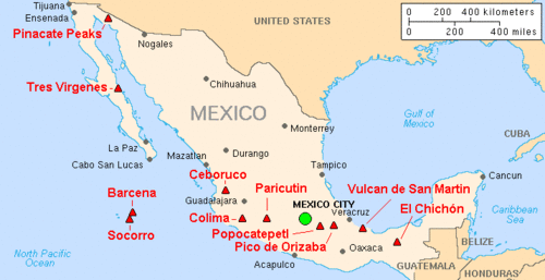
This is a list of active and extinct volcanoes in Mexico.
A volcanic hazard is a process that can cause damage to anything or anyone. Tephra/ash is a hazard caused by many volcanoes. Ash covers items like buildings, vehicles, homes, etc., and if "animals or humans consume fine-grained ash, it can cause health problems.." [3] Lahars are a kind of flowing volcanic hazard that can be harmful as they can take/drag anything in their way. Lahars can flow at varying speeds, making it difficult for people to escape from them. Pyroclastic flows, which are toxic gases created by hot clouds that can destroy all things they come into contact with, are another example of a volcanic hazard. Lava flows are the least deadly out of the volcanic hazards as "most move slowly enough that people can move out the way easily." [4] However, objects, people, and more that go near the lava flows "will be knocked over, surrounded, buried, or ignited by the extremely hot temperature of lava." [5]
A lot of earthquakes and volcanoes are in the pacific ring of fire. In addition, the ring of fire is “a direct result of plate tectonics, and the movement and collisions of lithospheric plates" [6] and Mexico’s volcanoes are part of this ring of fire. A specific Mexican volcano apart from the ring of fire is Popocatépetl, which is also one of the most dangerous volcanoes. This volcano lies “on the Trans-Mexican Volcanic Belt, which is the result of the small Cocos Plate sub-ducting beneath the North American Plate”. [7] The Popocatépetl volcano is a danger to a lot of people, so they have to be careful when or if this volcano erupts. In general, Mexico’s volcanoes are in the ring of fire, therefore people who live near the volcanoes listed above have to be careful with the volcanoes that will most likely erupt again.
When a volcano erupts, the communities around them are affected depending on how big of an eruption occurred. Popocatépetl is an excellent example of the effects that volcanoes can have on a community. Popocatépetl is a famous volcano due to it being inactive for 50 years and coming back to life in 1994. Since 1994, it has been producing powerful explosions at irregular intervals. In 2013, It released a cloud of ash that would spread for 2 miles high over a period of several days of eruptions. In the city of San Pedro Nexapa, about 9.5 from the Popocatépetl, local residents were able to find small piles of ash on parts of the sidewalk. It is easy for ash to get picked up by the wind, and get passed around contaminating the air. Cars driving by pick up the ash with their exhaust, and with the volcano still erupting irregularly, ash is periodically flowing out. Following the explosions, a total of 17 flights were canceled “due to climate conditions and in accordance with their own international policies.” [8] Other effects that volcanoes can have on communities in close proximity with the base are more in danger for ash clouds, mud flow, gases, earthquakes, and tsunamis. “During volcanic eruptions and their immediate aftermath, increased respiratory system morbidity has been observed as well as mortality among those affected by volcanic eruptions.” [9]
Environmental effects on growth and survival of trees in Mexico from volcanic activity are significant. Using evidence from the effects of the 1855 - 1856 eruption of that Tacaná volcano and ash fall from the 1902 eruption of the Santa Maria volcano and the radial growth of trees at Tacaná. Because of these incidents, they caused two significant suppression events to happen. The first event took place from 1857 to 1868 which caused by the historic eruption of Tacaná, two years prior. A year later after the eruption of the Santa Maria volcano, the second suppression event started from 1903 to 1908, during which tree growth was affected by the thickness of ash fall from the eruption and deposited near each tree. [10] Another example that the impact of volcano eruptions on forest ecosystems can be the 1913 Plinian eruption of Volćan de Fuego, 7.7 km to the south. This event was one of the largest explosive eruptions in Mexico and produced ash flow deposits up to 40 m thick. Also, this indicated extremely low growth in 1913 and 1914, radio growth reduction was over 30% in 75% of the sampled trees.[ citation needed ]

A volcano is a rupture in the crust of a planetary-mass object, such as Earth, that allows hot lava, volcanic ash, and gases to escape from a magma chamber below the surface.

A stratovolcano, also known as a composite volcano, is a conical volcano built up by many layers (strata) of hardened lava and tephra. Unlike shield volcanoes, stratovolcanoes are characterized by a steep profile with a summit crater and periodic intervals of explosive eruptions and effusive eruptions, although some have collapsed summit craters called calderas. The lava flowing from stratovolcanoes typically cools and solidifies before spreading far, due to high viscosity. The magma forming this lava is often felsic, having high to intermediate levels of silica, with lesser amounts of less viscous mafic magma. Extensive felsic lava flows are uncommon, but have traveled as far as 15 km (9 mi).

The Ring of Fire is a tectonic belt of volcanoes and earthquakes.

Volcanic cones are among the simplest volcanic landforms. They are built by ejecta from a volcanic vent, piling up around the vent in the shape of a cone with a central crater. Volcanic cones are of different types, depending upon the nature and size of the fragments ejected during the eruption. Types of volcanic cones include stratocones, spatter cones, tuff cones, and cinder cones.

A shield volcano is a type of volcano named for its low profile, resembling a shield lying on the ground. It is formed by the eruption of highly fluid lava, which travels farther and forms thinner flows than the more viscous lava erupted from a stratovolcano. Repeated eruptions result in the steady accumulation of broad sheets of lava, building up the shield volcano's distinctive form.

The Lassen volcanic area presents a geological record of sedimentation and volcanic activity in and around Lassen Volcanic National Park in Northern California, U.S. The park is located in the southernmost part of the Cascade Mountain Range in the Pacific Northwest region of the United States. Pacific Oceanic tectonic plates have plunged below the North American Plate in this part of North America for hundreds of millions of years. Heat and molten rock from these subducting plates has fed scores of volcanoes in California, Oregon, Washington and British Columbia over at least the past 30 million years, including these in the Lassen volcanic areas.

Mount Jefferson is a stratovolcano in the Cascade Volcanic Arc, part of the Cascade Range in the U.S. state of Oregon. The second highest mountain in Oregon, it is situated within Linn County, Jefferson County, and Marion County and forms part of the Mount Jefferson Wilderness. Due to the ruggedness of its surroundings, the mountain is one of the hardest volcanoes to reach in the Cascades. It is also a popular tourist destination despite its remoteness, with recreational activities including hiking, backpacking, mountaineering, and photography. Vegetation at Mount Jefferson is dominated by Douglas fir, silver fir, mountain hemlock, ponderosa pine, lodgepole pine, and several cedar species. Carnivores, insectivores, bats, rodents, deer, birds, and various other species inhabit the area.

Santa María Volcano is a large active volcano in the western highlands of Guatemala, in the Quetzaltenango Department near the city of Quetzaltenango. It is part of the mountain range of the Sierra Madre.

The Garibaldi Volcanic Belt is a northwest–southeast trending volcanic chain in the Pacific Ranges of the Coast Mountains that extends from Watts Point in the south to the Ha-Iltzuk Icefield in the north. This chain of volcanoes is located in southwestern British Columbia, Canada. It forms the northernmost segment of the Cascade Volcanic Arc, which includes Mount St. Helens and Mount Baker. Most volcanoes of the Garibaldi chain are dormant stratovolcanoes and subglacial volcanoes that have been eroded by glacial ice. Less common volcanic landforms include cinder cones, volcanic plugs, lava domes and calderas. These diverse formations were created by different styles of volcanic activity, including Peléan and Plinian eruptions.

An active volcano is a volcano that has erupted during the Holocene, is currently erupting, or has the potential to erupt in the future. A volcano that is not currently erupting but could erupt in the future is known as a dormant volcano. Volcanoes that will not erupt again are known as extinct volcanoes.

The Mount Meager massif is a group of volcanic peaks in the Pacific Ranges of the Coast Mountains in southwestern British Columbia, Canada. Part of the Cascade Volcanic Arc of western North America, it is located 150 km (93 mi) north of Vancouver at the northern end of the Pemberton Valley and reaches a maximum elevation of 2,680 m (8,790 ft). The massif is capped by several eroded volcanic edifices, including lava domes, volcanic plugs and overlapping piles of lava flows; these form at least six major summits including Mount Meager which is the second highest of the massif.

The Itcha Range, also known as the Itchas, is a small isolated mountain range in the West-Central Interior of British Columbia, Canada. It is located 40 km (25 mi) northeast of the community of Anahim Lake. With a maximum elevation of 2,375 m (7,792 ft), it is the lowest of three mountain ranges on the Chilcotin Plateau extending east from the Coast Mountains. Two mountains are named in the Itcha Range; Mount Downton and Itcha Mountain. A large provincial park surrounds the Itcha Range and other features in its vicinity. More than 15 animal species are known to exist in the Itcha Range area, as well as a grassland community that is limited only to this location of British Columbia. The Itcha Range is within territory which has been occupied by aboriginal peoples for millennia. This area has a relatively dry environment compared to the Coast Mountains in the west.

The Cascade Volcanoes are a number of volcanoes in a volcanic arc in western North America, extending from southwestern British Columbia through Washington and Oregon to Northern California, a distance of well over 700 miles (1,100 km). The arc formed due to subduction along the Cascadia subduction zone. Although taking its name from the Cascade Range, this term is a geologic grouping rather than a geographic one, and the Cascade Volcanoes extend north into the Coast Mountains, past the Fraser River which is the northward limit of the Cascade Range proper.

Several types of volcanic eruptions—during which material is expelled from a volcanic vent or fissure—have been distinguished by volcanologists. These are often named after famous volcanoes where that type of behavior has been observed. Some volcanoes may exhibit only one characteristic type of eruption during a period of activity, while others may display an entire sequence of types all in one eruptive series.

Volcanic activity is a major part of the geology of Canada and is characterized by many types of volcanic landform, including lava flows, volcanic plateaus, lava domes, cinder cones, stratovolcanoes, shield volcanoes, submarine volcanoes, calderas, diatremes, and maars, along with less common volcanic forms such as tuyas and subglacial mounds.
The Anahim hotspot is a hypothesized hotspot in the Central Interior of British Columbia, Canada. It has been proposed as the candidate source for volcanism in the Anahim Volcanic Belt, a 300 kilometres long chain of volcanoes and other magmatic features that have undergone erosion. This chain extends from the community of Bella Bella in the west to near the small city of Quesnel in the east. While most volcanoes are created by geological activity at tectonic plate boundaries, the Anahim hotspot is located hundreds of kilometres away from the nearest plate boundary.

The geology of the Pacific Northwest includes the composition, structure, physical properties and the processes that shape the Pacific Northwest region of North America. The region is part of the Ring of Fire: the subduction of the Pacific and Farallon Plates under the North American Plate is responsible for many of the area's scenic features as well as some of its hazards, such as volcanoes, earthquakes, and landslides.

The Silverthrone Caldera is a potentially active caldera complex in southwestern British Columbia, Canada, located over 350 kilometres (220 mi) northwest of the city of Vancouver and about 50 kilometres (31 mi) west of Mount Waddington in the Pacific Ranges of the Coast Mountains. The caldera is one of the largest of the few calderas in western Canada, measuring about 30 kilometres (19 mi) long (north-south) and 20 kilometres (12 mi) wide (east-west). Mount Silverthrone, an eroded lava dome on the caldera's northern flank that is 2,864 metres (9,396 ft) high, may be the highest volcano in Canada.

The Canadian Cascade Arc, also called the Canadian Cascades, is the Canadian segment of the North American Cascade Volcanic Arc. Located entirely within the Canadian province of British Columbia, it extends from the Cascade Mountains in the south to the Coast Mountains in the north. Specifically, the southern end of the Canadian Cascades begin at the Canada–United States border. However, the specific boundaries of the northern end are not precisely known and the geology in this part of the volcanic arc is poorly understood. It is widely accepted by geologists that the Canadian Cascade Arc extends through the Pacific Ranges of the Coast Mountains. However, others have expressed concern that the volcanic arc possibly extends further north into the Kitimat Ranges, another subdivision of the Coast Mountains, and even as far north as Haida Gwaii.

Naolinco volcanic field is a volcanic field in Veracruz, Mexico. It lies in the region of the cities of Jalapa and Naolinco, and the town of Naolinco lies in the field.
{{cite web}}: |last= has generic name (help)