Amtrak's Southwest Chief train passing Devil's Throne, an igneous intrusion rising to an altitude of 5,638ft (1,718m) approximately 3⁄4mi (1.2km) northwest of Los Cerrillos (2017)
As of the census[7] of 2000, there were 229 people, 111 households, and 59 families residing in the CDP. The population density was 164.5 inhabitants per square mile (63.5/km2). There were 129 housing units at an average density of 92.7 per square mile (35.8/km2). The racial makeup of the CDP was 79.04% White, 0.44% Native American, 0.44% Asian, 16.16% from other races, and 3.93% from two or more races. Hispanic or Latino of any race were 50.66% of the population.
There were 111 households, out of which 21.6% had children under the age of 18 living with them, 42.3% were married couples living together, 7.2% had a female householder with no husband present, and 46.8% were non-families. 41.4% of all households were made up of individuals, and 7.2% had someone living alone who was 65 years of age or older. The average household size was 2.06 and the average family size was 2.83.
In the CDP, the population was spread out, with 17.9% under the age of 18, 2.2% from 18 to 24, 31.9% from 25 to 44, 33.2% from 45 to 64, and 14.8% who were 65 years of age or older. The median age was 44 years. For every 100 females, there were 99.1 males. For every 100 females ages 18 and over, there were 106.6 males.
The median income for a household in the CDP was $13,661, and the median income for a family was $31,161. Males had a median income of $30,446 versus $31,250 for females. The per capita income for the CDP was $14,215. About 25.9% of families and 18.4% of the population were below the poverty line, including none of those under the age of eighteen or sixty-five or over.
History
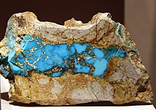
A fine Cerrillos Turquoise specimen at the Smithsonian
The first, confirmable human presence on the Galisteo River occurred around 10,500 years ago. Over the centuries, both large and small communities spread throughout the Galisteo Basin.[8] Archeological evidence of pre-Columbian human inhabitants includes pottery, vases, cups, eating and cooking utensils, stone hammers, wedges, mauls, and religious items.[9]
The Ancestral Puebloans began mining Cerrillos turquoise in approximately 700-900 AD.[8][10][11] Evidence of established long-term settlements, dating back to the 13th century, includes pit-house villages. In the 14th century, there was increased upheaval and conflict between communities, including the burning of the Burnt Corn Ruin. During the 15th century, an influx of Apache and Navajo in the Galisteo Basin influenced and impacted the Puebloans. By the time Francisco Vázquez de Coronado arrived in the region, circa 1540-42, a number of indigenous settlements were abandoned.[8]
Mining in the Cerrillos Hills continued with the arrival of Spanish colonizers. The Native peoples were used for slave labor to mine these materials out of the hills under Spanish colonial rule.[9] In 1581, the Spanish identified lead-silver deposits in “Sierra de San Mateo,” the modern Cerrillos Hills. At the turn of the 17th century, the Spanish permanently settled in the area. During the 1660s, however, a drought put economic pressure on the Spanish, while Puebloans abandoned settlements and Plains Indians conducted raids.[8]
A Spanish explorer, Antonio de Espejo, wrote about these treasures being mined at a place of “little hills." This is the source of Cerrillos' name.[citation needed]
In 1680, a landslide occurred in the hills, causing mines to cave-in and around 25 miners were buried. When the Spanish attempted to restart mining operations, the Native workers revolted.[8][11] Around 1695-1696 Diego de Vargas appointed Alonso Rael de Aguilar as alcalde of the mining camp El Real de Los Cerrillos.[10] However, tumultuous events in the late 17th century – drought, small pox, and ongoing raids – effectively ended Native turquoise mining. The Tewa people left the area, though there were efforts in the early 18th century to repopulate with reassembled Tanos.[8]
During the 18th century, the Spanish continued to register land grants and mine claims in the area. The earliest well-documented Spanish mine claim was registered in 1709 by General Don Juan de Ulibarri. After Mexican Independence, restrictions on foreign visitors in New Mexico were lifted in 1821, increasing trade. Following the end of the Mexican–American War in 1848, the US Government manipulated land grants to make it easier for Anglo-Americans to purchase land. Between 1846-1869, the Cerrillos Hills were claimed by the Baca y Delgado Family Land Grant. In 1870, the US Government rejected the family’s grant claim and made the land available for public purchase.[8]
In 1871, Stephen B. Elkins purchased 606 acres of US Government land located along the Galisteo River. He planned to build a mining town on the railroad.[12] In the same year, Elkins gained ownership of the Ortiz Mining Grant, which contained coal deposits. Frank Dimmick and Robert Hart registered their Bonanza #3 claim in the Cerrillos Hills on January 15, 1879.[10] The two Colorado miners set up camp and by 1880 there were five camps with a combined population of between 1,200 to 1,500 people.[11] Further discovery of precious metal deposits led to increased immigration and an economic boom.[9] Eventually, there were over 2,000 Territorial mines established in the hills. March 8, 1880 was declared Cerrillos Founder's Day. In addition to turquoise, the mines produced gold, copper, silver, galena, manganese, and iron.[10]
Cerrillos Station was connected to the railway on February 15, 1880.[12] The main line of the Atchison, Topeka and Santa Fe Railway ran within only three miles of Los Cerillos.[9] The rapid growth of Cerrillos gave opportunities to people who moved in. During the 1880s, the rate of development increased around Cerrillos Station and saloons, a school, churches, stores, and hotels were built.[10]
In either 1899[10] or 1901,[12] electricity was first supplied to the town of Cerillos by the Cochiti Gold Mining Company electric plant in Madrid, New Mexico. Telephone lines arrived in 1905.[10][12] By 1900, the mines began to shut down.[citation needed] The population of the area dwindled during the Great Depression and World War II.[12] In 1961, the Cerrillos primary school was closed due to shrinking enrollment and financial difficulties.[10]
Today, only a few of the buildings from Cerrillos' boom remain. Some of the buildings still show evidence of past movies filmed ("Young Guns" and "Outrageous Fortune") on Main Street.[citation needed] In January 2000, Santa Fe County purchased 1,116 acres of the Cerrillos Hills and created the Santa Fe County Cerrillos Hills Historic Park. In 2009, the park was renamed Cerrillos Hills State Park.[10]
Santa Fe County is located in the U.S. state of New Mexico. As of the 2020 census, the population was 154,823, making it New Mexico's third-most populous county, after Bernalillo County and Doña Ana County. Its county seat is Santa Fe, the state capital.
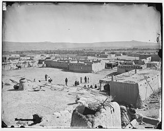
Cochiti is a census-designated place (CDP) in Sandoval County, New Mexico, United States. A historic pueblo of the Cochiti people, one of the Keresan Nations, it is part of the Albuquerque Metropolitan Statistical Area. The population was 528 at the 2010 census. Located 22 miles (35 km) southwest of Santa Fe, the community is listed as a historic district on the National Register of Historic Places.
Kewa Pueblo is a federally-recognized tribe of Native American Pueblo people in northern New Mexico, in Sandoval County southwest of Santa Fe. The pueblo is recorded as the Santo Domingo Pueblo census-designated place by the U.S. Census Bureau, with a population of 2,456 at the 2010 census.
Agua Fria is a census-designated place (CDP) in Santa Fe County, New Mexico, United States. It is part of the Santa Fe, New Mexico Metropolitan Statistical Area. The population was 2,800 at the 2010 census. Agua Fria Village is a "Traditional Historic Community" (THC) as designated by the Santa Fe Board of County Commissioners in 1995 and subsequent Santa Fe County Ordinance #1996-16, as allowed by State Statute.
Cedar Grove is a census-designated place (CDP) in Santa Fe County, New Mexico, United States. It is part of the Santa Fe, New Mexico Metropolitan Statistical Area. The population was 747 at the 2010 census.
Cuyamungue is a census-designated place (CDP) in Santa Fe County, New Mexico, United States. It is part of the Santa Fe, New Mexico Metropolitan Statistical Area. The population was 479 at the 2010 census.
El Rancho is a census-designated place (CDP) in Santa Fe County, New Mexico, United States. It is part of the Santa Fe, New Mexico Metropolitan Statistical Area. The population was 1,199 at the 2010 census.
El Valle de Arroyo Seco is a census-designated place (CDP) in Santa Fe County, New Mexico, United States. It is part of the Santa Fe, New Mexico Metropolitan Statistical Area. The population was 1,440 at the 2010 census.
Eldorado at Santa Fe, locally known as Eldorado, is a census-designated place (CDP) in Santa Fe County, New Mexico, United States. It is part of the Santa Fe, New Mexico Metropolitan Statistical Area. The population was 6,130 at the 2010 census.
Galisteo is a census-designated place (CDP) in Santa Fe County, New Mexico, United States. It is part of the Santa Fe, New Mexico Metropolitan Statistical Area. The population was 253 at the 2010 census.
La Cienega is a census-designated place (CDP) in Santa Fe County, New Mexico, United States. It is part of the Santa Fe, New Mexico, metropolitan statistical area. The population was 3,007 at the 2000 census.
Lamy is a census-designated place (CDP) in Santa Fe County, New Mexico, United States, 18 miles (29 km) south of the city of Santa Fe. The community was named for Archbishop Jean-Baptiste Lamy, and lies within the Bishop John Lamy Spanish Land Grant, which dates back to the eighteenth century.
Madrid is a census-designated place (CDP) in Santa Fe County, New Mexico, United States. It is part of the Santa Fe, New Mexico Metropolitan Statistical Area. The population was 149 at the 2000 census and 204 in 2010. Today, Madrid has become an artists' community with galleries lining New Mexico State Road 14. It retains remnants of its history with the Mineshaft Tavern and the Coal Mine Museum.
Pojoaque, Po’su wae geh, which translates to “water gathering place”, is a census-designated place (CDP) in Santa Fe County, New Mexico, United States. It is part of the Santa Fe, New Mexico Metropolitan Statistical Area. The population was 1,907 at the 2010 census. Pojoaque Pueblo, a neighboring community, is an Indian reservation, and the town of Pojoaque is a collection of communities near the pueblo with people from various ethnic backgrounds. The area of Pojoaque includes the neighborhoods of Cuyamungue, Jacona, Jaconita, Nambé and El Rancho.
Santa Cruz is a census-designated place (CDP) in Santa Fe County, New Mexico, United States. It is part of the Santa Fe, New Mexico Metropolitan Statistical Area. The population was 423 at the 2000 census.
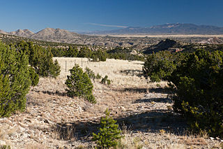
Cerrillos Hills State Park is a state park of New Mexico, located 16 miles (26 km) south of Santa Fe. Transferred to state ownership in 2009, it is New Mexico's newest state park. The hills in the park range in elevation from 6,000 feet (1,800 m) to 6,900 feet (2,100 m) above sea level. The visitors' center is located in the village of Los Cerrillos. The park has numerous hiking trails.
Bonanza City is a ghost town, located 13 miles (21 km) southwest of Santa Fe in Santa Fe County, New Mexico, United States. The town was founded in 1880 as a mining town, following the discovery of gold and silver in the nearby Cerrillos Hills. It was abandoned sometime in the early 1900s. Later in the 20th century, The Bonanza Creek Movie Ranch, which contains a movie set depicting a late 19th century mining town, was built near the ruins of Bonanza City.
Golden is a census-designated place (CDP) located between the towns of Cedar Crest and Madrid in Santa Fe County, New Mexico, United States.
The Cerrillos Turquoise Mines are Ancestral Puebloan turquoise mines located in the Cerrillos Hills, 20 miles (32 km) southwest of Santa Fe, New Mexico. Archeologists believe that most of the turquoise found at Chaco Canyon was mined in the Cerrillos Hills. Many modern Pueblo people claim to have ancient rights to these mines. In 1977, neutron activation analysis linked an artifact from Chetro Ketl to the Cerrillos mines.
Harris, Linda G., Ghost Towns Alive, University of New Mexico Press, 2003
Sherman, James E. and Barbara, Ghost Towns and Mining Camps of New Mexico, University of Oklahoma Press, Norman, Publishing Division of the University, 1975
Simmons, Marc, Turquoise and Six Guns The Story of Cerrillos, New Mexico, The Sunstone Press Santa Fe, New Mexico, 1974
Lawson, Jacqueline E., Cerrillos Yesterday, Today and Tomorrow The Story of a Won’t –Be Ghost Town, The Sunstone Press Santa Fe New Mexico, 1989
This page is based on this Wikipedia article Text is available under the CC BY-SA 4.0 license; additional terms may apply. Images, videos and audio are available under their respective licenses.