Los Trujillos-Gabaldon, New Mexico

Last updated
Los Trujillos-Gabaldon, New Mexico
CDP
Valencia County New Mexico Incorporated and Unincorporated areas Los Trujillos-Gabaldon Highlighted.svg
Location of Los Trujillos-Gabaldon, New Mexico
Usa edcp location map.svg
Red pog.svg
Los Trujillos-Gabaldon, New Mexico
Location in the United States
Coordinates: 34°39′47″N106°45′32″W / 34.66306°N 106.75889°W / 34.66306; -106.75889
Country United States
State New Mexico
County Valencia
Area
  Total5.9 sq mi (15.4 km2)
  Land5.9 sq mi (15.4 km2)
  Water0.0 sq mi (0.0 km2)
Population
 (2000)
  Total2,166
  Density364.9/sq mi (140.9/km2)
Time zone UTC-7 (Mountain (MST))
  Summer (DST) UTC-6 (MDT)
Area code 505
FIPS code 35-44145

Los Trujillos-Gabaldon is a census-designated place (CDP) in Valencia County, New Mexico, United States. The population was 2,166 at the 2000 census. It is part of the Albuquerque Metropolitan Statistical Area.

Contents

Geography

Los Trujillos-Gabaldon is located at 34°39′47″N106°45′32″W / 34.66306°N 106.75889°W / 34.66306; -106.75889 (34.663188, -106.759012). [1]

According to the United States Census Bureau, the CDP has a total area of 5.9 square miles (15 km2), all land.

Demographics

As of the census of 2000, there were 2,166 people, 804 households, and 598 families residing in the CDP. The population density was 364.9 inhabitants per square mile (140.9/km2). There were 870 housing units at an average density of 146.6 units per square mile (56.6 units/km2). The racial makeup of the CDP was 71.93% White, 1.15% African American, 2.31% Native American, 0.18% Asian, 19.62% from other races, and 4.80% from two or more races. Hispanic or Latino of any race were 62.47% of the population.

There were 804 households, out of which 32.3% had children under the age of 18 living with them, 56.3% were married couples living together, 12.9% had a female householder with no husband present, and 25.6% were non-families. 20.0% of all households were made up of individuals, and 7.1% had someone living alone who was 65 years of age or older. The average household size was 2.69 and the average family size was 3.09.

In the CDP, the population was spread out, with 26.4% under the age of 18, 8.9% from 18 to 24, 26.8% from 25 to 44, 25.2% from 45 to 64, and 12.8% who were 65 years of age or older. The median age was 37 years. For every 100 females, there were 97.8 males. For every 100 females age 18 and over, there were 99.1 males.

The median income for a household in the CDP was $28,989, and the median income for a family was $35,433. Males had a median income of $28,661 versus $21,492 for females. The per capita income for the CDP was $13,959. About 12.8% of families and 15.4% of the population were below the poverty line, including 17.4% of those under age 18 and 16.9% of those age 65 or over.

Related Research Articles

<span class="mw-page-title-main">Valencia County, New Mexico</span> County in New Mexico, United States

Valencia County is a county in the U.S. state of New Mexico. As of the 2010 census, the population was 76,569. The county seat is Los Lunas.

<span class="mw-page-title-main">Parks, Arizona</span> CDP in Coconino County, Arizona

Parks is a census-designated place (CDP) in Coconino County, Arizona, United States. The population was 1,188 at the 2010 census.

<span class="mw-page-title-main">Mesquite Creek, Arizona</span> CDP in Mohave County, Arizona

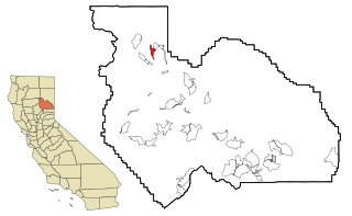
Mesquite Creek is an unincorporated community and census-designated place (CDP) in Mohave County, Arizona, United States. The population was 403 at the 2020 census.

<span class="mw-page-title-main">Vincent, California</span> Census-designated place in California, United States

Vincent is a census-designated place (CDP) in the central San Gabriel Valley, in Los Angeles County, California, United States. The city name and zipcode for addresses south of Arrow Highway is Covina and 91722, respectively, and Azusa and 91702 for addresses north of Arrow Highway. The population was 15,922 at the 2010 census, up from 15,097 at the 2000 census. Vincent is named after Vincent Avenue, which passes through the community.

<span class="mw-page-title-main">Lake Almanor Country Club, California</span> Census-designated place in California, United States

Lake Almanor Country Club is a census-designated place (CDP) in Plumas County, California, United States. The population was 419 at the 2010 census, down from 847 at the 2000 census. The ZIP code for the CDP is 96137.

<span class="mw-page-title-main">Maugansville, Maryland</span> CDP in Maryland, United States

Maugansville is a census-designated place (CDP) in Washington County, Maryland, United States. The population was 2,295 at the 2000 census.

<span class="mw-page-title-main">Society Hill, Middlesex County, New Jersey</span> Populated place in Middlesex County, New Jersey, US

Society Hill is an unincorporated community and census-designated place (CDP) located within Piscataway Township, in Middlesex County, in the U.S. state of New Jersey. As of the 2010 United States Census, the CDP's population was 3,829.

<span class="mw-page-title-main">Isleta Village Proper, New Mexico</span> Census-designated place in New Mexico, United States

Isleta Village Proper is a census-designated place (CDP) in Bernalillo County, New Mexico, United States. The population was 491 at the 2010 census. It is part of the Albuquerque Metropolitan Statistical Area.

<span class="mw-page-title-main">San Juan, New Mexico</span> CDP in New Mexico, United States

San Juan is a census-designated place (CDP) in Rio Arriba County, New Mexico, United States. The population was 592 at the 2000 census.

<span class="mw-page-title-main">Peña Blanca, New Mexico</span> CDP in New Mexico, United States

Peña Blanca is a census-designated place (CDP) in Sandoval County, New Mexico. As of the 2000 census, the CDP population was 661. It is part of the Albuquerque Metropolitan Statistical Area.

<span class="mw-page-title-main">Regina, New Mexico</span> CDP in New Mexico, United States

Regina is a census-designated place (CDP)) in Sandoval County, New Mexico, United States. The population was 99 at the 2000 census. It is part of the Albuquerque Metropolitan Statistical Area. It was named for Regina, Saskatchewan.

<span class="mw-page-title-main">San Felipe Pueblo, New Mexico</span> CDP in New Mexico, United States

San Felipe Pueblo is a census-designated place (CDP) in Sandoval County, New Mexico, United States, and is located 10 miles (16 km) north of Bernalillo. As of the 2000 census, the CDP population was 2,080. It is part of the Albuquerque Metropolitan Statistical Area.

<span class="mw-page-title-main">Rio Communities, New Mexico</span> City in New Mexico, United States

Rio Communities is a city in Valencia County, New Mexico, United States. Prior to its incorporation on May 16, 2013, it was a census-designated place (CDP). The CDP population was 4,723 as of the 2010 census.

<span class="mw-page-title-main">Rio Communities North, New Mexico</span> CDP in New Mexico, United States

Rio Communities North is a census-designated place (CDP) in Valencia County, New Mexico, United States. The population was 1,588 at the 2000 census. It is part of the Albuquerque Metropolitan Statistical Area.

<span class="mw-page-title-main">Tome-Adelino, New Mexico</span> Former Census-designated place in New Mexico, United States

Tome-Adelino is a former census-designated place (CDP) in Valencia County, New Mexico, United States. The population was 2,211 at the 2000 census. It is part of the Albuquerque Metropolitan Statistical Area. For the 2010 census, the CDP was split into the census-designated places of Tome and Adelino.

<span class="mw-page-title-main">Valencia, Valencia County, New Mexico</span> CDP in New Mexico, United States

Valencia is a census-designated place (CDP) in Valencia County, New Mexico, United States. The population was 2,192 at the 2010 census. It is part of the Albuquerque Metropolitan Statistical Area.

Simms is a census-designated place (CDP) in Muskogee County, Oklahoma, United States. The population was 295 at the 2000 census.

Antelope Hills is a census-designated place in Natrona County, Wyoming, United States. It is part of the Casper, Wyoming Metropolitan Statistical Area. The population was 97 at the 2010 census.

<span class="mw-page-title-main">Sandwich (CDP), Massachusetts</span> Census-designated place in Massachusetts, United States

Sandwich is a village and census-designated place (CDP) in the town of Sandwich in Barnstable County, Massachusetts, United States. The population was 2,962 at the 2010 census, out of a total 20,675 people in the town of Sandwich.

<span class="mw-page-title-main">Freeport (CDP), Maine</span> Census-designated place in Maine, United States

Freeport is a census-designated place (CDP) in the town of Freeport in Cumberland County, Maine, United States. The population was 1,485 at the 2010 census. It is part of the Portland–South Portland–Biddeford, Maine Metropolitan Statistical Area.

References

  1. "US Gazetteer files: 2010, 2000, and 1990". United States Census Bureau. 2011-02-12. Retrieved 2011-04-23.